Throughout most of Tennessee, ancient rocks formed during the Precambrian Era over 1 billion years ago lie below the surface of sedimentary rock; however, in the Unaka Range the ancient rocks are exposed. About 600 million years ago, sediments collected in a sinking trough (geosyncline) on the Unakas' western side and formed the Ocoee Supergroup and Chilhowee Group that make up most of the present-day Unaka Range. A period of folding took place about 470 million years ago during the Ordovician Period, when the older rock was forced over the younger rock of the Ocoee and Chilhowee formations.
Eroded Precambrian rock and marine debris settled into another geosyncline between the Devonian and the Triassic periods, forming new layers of sedimentary rock. In the final phase of the formation of the Unakas, these strata were pushed into mountains during the Alleghanian orogeny, when North America collided with Africa 290 million years ago. Many thousands of feet of rock folded like a rug pushed from one end. The pressure generated great heat, melting and fusing the rock of the Unakas into what is called metamorphic rock.
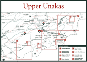
The Unaka Range runs along Tennessee's border with North Carolina and has three divisions: the Upper Unakas, the Great Smoky Mountains, and the Lower Unakas. Tennessee's Upper Unakas are sandwiched between the North Carolina border on the east and the Tennessee cities of Bristol, Elizabethton, Johnson City, Greeneville, and Newport on the west. Virginia is the northern border, and the Great Smoky Mountains form the southern line of demarcation.
The Unakas include the Cherokee National Forest (CNF), which is divided into
the northern CNF, which is in the Upper Unakas, and the southern CNF in the
Lower Unakas. The CNF covers more than 633,000 acres in 10 east Tennessee counties
from Bristol to Chattanooga.
The northern and southern divisions of the CNF are subdivided into ranger districts. In the northern CNF, there are two ranger districts: the Watauga and the Nolichucky/Unaka ranger districts. In the southern CNF, there are currently three districts: the Tellico, Hiwassee, and Ocoee ranger districts.
At this writing, plans are underway to change the southern CNF districts from three districts into two. Since the southern district's plans have not been completed, this book will treat the CNF as five distinct districts, two in the northern CNF and three in the southern portion.
In the northern CNF there are four designated wilderness areas and five scenic areas, as well as 169 miles of protected area along the Appalachian Trail. Scenic drives ranging from short outings to all-day trips are possible on the northern CNF's 650 miles of roads. All seasons have much to offer those looking at landscapes and panoramic vistas. Outdoor enthusiasts find hiking, camping, fishing, hunting, whitewater rafting, canoeing, picnicking, biking, horseback riding, swimming, and wildlife viewing among the many opportunities in the CNF.
In the northern CNF, there are 74 hiking trails covering 391 miles and ranging in difficulty from easy to extremely strenuous. CNF maps designate trails with numbers instead of names. For example the Appalachian Trail is Trail #1, and the Holston Mountain Trail is Trail #44. Hereafter, the text will give the name of a trail with its number in parenthesis. Loop and one-way trails are available to hikers with no permits or check-ins required, but for safety, leave detailed hiking plans with someone.
Six whitewater streams can add excitement to a CNF visit. Commercial outfitters will rent you gear or you can strike out on your own, if you are experienced, to float the Pigeon, French Broad, and Nolichucky rivers. South Holston, Watauga, Tellico, Chilhowee, Calderwood, Ocoee, Indian Boundary, and McKamy lakes provide opportunities for fishing, boating, and swimming.
A wilderness area in a national forest is defined by the National Wilderness Preservation Act of 1964 as an area of undeveloped, federally owned land that is designated by Congress and has the following characteristics: (1) Primarily the forces of nature affect it, where man is a visitor who does not remain. It may contain ecological, geological, or other features of scientific, educational, scenic, or historical value. (2) It possesses outstanding opportunities for solitude or a primitive and unconfined type of recreation. (3) It is an area large enough so that continued use will not change its unspoiled, natural condition.
For protection, certain uses of wilderness areas are not encouraged. Trapping, hunting, and fishing are allowed during their seasons; however, they must be done in a way that is consistent with the wilderness character. Only nonmotorized and nonmechanical methods of travel are permissible, except in an emergency. Emergency categories include removal of deceased persons, law enforcement involving serious crime or fugitive pursuit, health and safety, and fire suppression.
Wilderness areas require the practice of "leave no trace." Leave no trace means exactly that—if you took it in, take it out, and if you didn't take it in, don't take it out. Call (800) 332-4100 for more information and educational materials on leave no trace practices.
Scenic areas are areas of another type within national forests. Guidelines for managing scenic areas are less restrictive than management guidelines for wilderness areas. Scenic areas possess unusual recreation and scientific values, and timber may be cut to enhance vistas, remove hazards, and remove diseased trees.
Fraser fir (Abies fraseri), Eastern hemlock (Tsuga canadensis), red spruce (Picea rubens), table mountain pine (Pinus pungens), chestnut oak (Quercus prinus), scarlet oak (Quercus coccinea), white oak (Quercus alba), yellow-poplar (Liriodendron tulipifera), sugar maple (Acer saccharum), yellow birch (Betula alleghaniensis), northern red oak (Quercus rubra), hickories (Carya sp.), Virginia pine (Pinus virginiana), pitch pine (Pinus rigida), white pine (Pinus strobus), sweet gum (Liquidamber styraciflua), sycamore (Plantanus occidentalis), black cherry (Prunus serotina), and beech (Fagus grandifolia) commonly compose the forests of the Upper Unakas. Some stands of scarlet oak over 100 years old can be see in the Pond Mountain Wilderness Area. Extensive logging occurred between 1913 and 1927 throughout the Upper Unakas, but some timber stands date back to 1861.
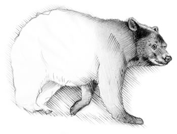
Black bear (Ursus americanus), bobcat (Felis rufus), white-tailed deer (Odocoileus virginianus), ruffed grouse (Bonasa umbellus), turkey (Meleagris gallopavo), gray squirrel (Sciurus carolinensis), largemouth bass (Micropterus salmoides), brown trout (Salmo trutta), brook trout (Salvelinus fontinalis), rainbow trout (Salmo gairdneri), bream (Lepomis sp.), and catfish (Ictalurus sp.) are game animals found in the Cherokee National Forest in the Upper Unakas. To see red foxes (Vulpes vulpes), turkey, wild hogs, and bears you need patience and perseverance, for these are elusive and reclusive animals. The mountains are marginal territories for deer, but they are present and less elusive than most big game animals. Chances are excellent you will see some of the 23 species of reptiles, 32 amphibians, 43 mammals, 140 fish, and 150 birds in the northern CNF.