The Watauga Ranger District (approximately 170,000 acres) is mountainous, with elevations ranging from 1,500 feet in the river valleys to 4,321 feet on Holston Mountain, 4,880 feet on Rogers Ridge, and 4,329 feet on Pond Mountain. This district contains two wilderness areas, two scenic areas, developed campgrounds, 177 campsites, 181 miles of trails, including 20 miles of horse trails, 300 miles of U.S. Forest Service roads, seven developed picnic areas, three developed swimming areas, four boat ramps, and two shooting ranges. All this falls within the four northeastern counties of Tennessee: Carter, Johnson, Sullivan, and Unicoi.
The headquarters for the Watauga Ranger District is at 4400 Unicoi Drive in Unicoi about 0.5 mile east of Exit 23 of US 19/23. This office should be your first stop for information, maps, and knowledge of any recent changes within the district. For instance, damage from a flood in early 1998 may have lingering effects, such as closures of some areas.
Three lakes offer excellent rainbow trout and smallmouth fishing. South Holston Lake (7,580 acres in Tennessee and Virginia) also contains walleye, white bass, crappie, largemouth bass, sauger, catfish, and bream. Watauga Lake (6,430 acres) and Wilbur Lake (72 acres) contain lake trout, walleye, white bass, catfish, bream, crappie, and largemouth bass. Watauga Lake holds the state record for lake trout: 20 pounds and 0.79 ounces.
The Watauga Ranger District, along with the rest of the CNF, is part of the Cherokee Wildlife Management Area and is managed cooperatively by the U.S. Forest Service and Tennessee Wildlife Resources Agency for fishing and hunting, as well as wildlife viewing. During the hunting season several gated roads are opened to hunters, but these change each year.
In the Watauga District, the Tennessee Wildlife Resources Agency (TWRA) stocks Laurel Creek, Gentry Creek, and Beaverdam Creek. Other streams stocked by TWRA in Johnson and Carter counties include Buffalo Creek, Watauga River, Simerly Creek, Laurel Fork Creek, Doe River, Big Stoney Creek, Upper Roan Creek, Laurel Bloomery Creek, and Forge Creek. These creeks are on both national forest and private land.
The U.S. Forest Service began buying land from willing sellers in this area
back in 1913. The Watauga Ranger District, founded that year, was part of the
White Top National Forest until 1920 when it became part of the Unaka National
Forest. It became what it is today, part of the Cherokee National Forest, in
1936.

[Fig. 27(3)] The Rogers Ridge Scenic Area (3,865 acres) is in the northeastern corner of Johnson County and is bordered by North Carolina and Virginia to the east and Virginia to the north. It offers vistas of several popular mountains in the southern highlands: Grandfather and Roan to the south in North Carolina, and Whitetop and Mount Rogers to the north in Virginia. Also, Rogers Ridge Scenic Area's Gentry Creek Falls and balds are touted as the loveliest in the southern highlands.
Within the scenic area are many wildflowers including Appalachian twayblade (Listera smallii), rock bells (Aquilegia canadensis), Robbins ragwort (Senecio schweinitzianus), and rattlesnake root (Prenanthes altissima). Here and throughout the CNF, deer and turkey sightings abound.
Balds like the ones in Rogers Ridge Scenic Area are large grassy areas that appear in stark contrast to their surrounding environs. They are treeless areas ranging in size from a few acres to many. Controversy abounds as to how balds came to exist, and there are many theories. Some claim these are naturally occurring spaces caused by wind, ice, storms, or other natural calamities. Others say they were man-made. Indians may have burned the areas so grass could grow to be used for grazing game animals and to improve hunting. Early settlers may have cleared the areas for cattle. According to one theory, balds may be the result of animals instead of man. Before man inhabited the region, mastodons, ground sloths, and later bison and elk may have grazed and cleared the areas. There may be more than one reason for the various balds. These open spaces provide opportunities for wildlife viewing, hiking, camping, and enjoying the unobstructed views.
[Fig. 27(2)] The Rogers Ridge Scenic Area features the Rogers Ridge Horse Trail (#192). This is the main trail in the area. The Rogers Ridge Horse Trail climbs and follows Rogers Ridge to the intersection with old Dry Branch Road. The trail follows Dry Branch Road for 2.1 miles into a series of balds that offer spectacular views of Tennessee, Virginia, and North Carolina, and it then ends at the hitching rails near the Mount Rogers United States Geological Survey benchmark. The trail does not connect with roads on private land at the Tennessee/North Carolina/Virginia border.
[Fig. 27(3)] Reaching Gentry Creek Falls requires a 4.6-mile round-trip hike
that climbs 1,200 feet. A good trail deteriorates to a primitive trail after
a point. The 15 creek crossings on this trail can be dangerous during high
water. The waterfall is an attractive, two-tiered, 40-foot, double horsetail-shaped
falls.

[Fig. 28] The Backbone Rock Recreation Area has four major features that attract visitors: the trout stream, the trails, the falls, and Backbone Rock. Backbone Rock Recreation Area is known for the unique rock formation located where Beaverdam Creek flows past a spur ridge of Holston Mountain. The spur ends sharply at a large bend in the creek and is named Backbone because it resembles a spine. The spine is a wall of sandstone about 50 feet thick that rises nearly a hundred feet and runs for several hundred feet. A tunnel was drilled 22 feet through Backbone Rock in 1901 to allow a railroad to operate, creating what was called the "shortest tunnel in the world." After the timber was harvested, the railroad was abandoned and later became TN 133 that now runs through the tunnel.
In 1913, the Forest Service bought 22,000 acres around Backbone Rock, and during the early 1920s, people began using it for recreation. The Civilian Conservation Corps (CCC) built a picnic and camping area here in the 1930s. All 11 campsites in the area were reworked during 1994 and 1995 to accommodate camping equipment from tents to RVs. The U.S. Forest Service also completely restored two CCC-era picnic pavilions and made general improvements to the area.
Some stands of white pine in the Backbone Rock Recreation Area were planted after logging was completed. Wildflowers are another attraction when they bloom along the creek bottom. Early saxifrage (Saxifraga virginiensis) and grass-of-parnassus (Parnassia asarifolia) are two notables. On the Backbone Rock Trail, about 250 feet before it intersects the AT, is a colony of the rare shinleaf (Pyrola elliptica) that blooms in June.
Beaverdam Creek flows through public land, but only for 6 miles. One of many access points to the public stream is at the TN 133 bridge north of Crandull. The highway and the stream run parallel for about 6 miles northeast into Virginia.
Tennessee's trout streams contain rainbow and brown trout that were introduced during the early part of the 1900s when improper logging practices destroyed the habitat of the brook trout. Restoration of the brook trout and its habitat has been successful in the higher elevations. The brook trout in the tributaries of Beaverdam are wild, not stocked, fish that have survived.
Beaverdam Creek is a very popular stream, and wild rainbows and browns can be caught here. There are also abundant trout in the CNF section of the creek. The upper part of Beaverdam and its tributaries in the CNF are wild trout streams with special regulations: three trout limit, single hook, and artificial lures, flies, etc. only.
[Fig. 28(3)] The Backbone Falls Trail (#198), a short loop trail, begins
and ends in the parking lot at the south end of the recreation area. It is
an easy walk with CCC-era rockwork and steep drop-offs. Adult supervision of
children is recommended. The trail passes Backbone Falls 0.1 mile from the
parking lot. This falls is small with a horsetail form.
[Fig. 28(1)] The Backbone Rock Trail (#53), a 2.36-mile hike, begins at the parking area on TN 133 and climbs many steps to the top of Backbone Rock. One spur of this trail veers over the top of the rock with a solid path and steep drop-offs and leads to the picnic area on the south side of TN 133. The main trail continues to the crest of Holston Mountain where it intersects the AT (#1).
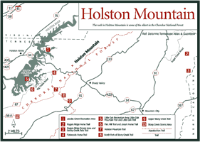
[Fig. 27] Holston Mountain, running 30 miles from Elizabethton to Damascus, Virginia, is part of the Upper Unaka Mountains.
The rock in this mountain is some of the oldest in the CNF. Ancient metamorphic rock (schist and gneiss) and igneous rock (granite and gabbro) form the basement complex.
The mountain is crisscrossed with trails for hiking and horses. Three of the trails are in the Stony Creek Scenic Area and are described in that section. The others are described here in order from the northern part of Holston Mountain to the southern end.
[Fig. 27(6)] The Flint Mill Trail (#49) leaves FR 87 just south of the junction with FR 87A and FR 87D, and it heads south, climbing Holston Mountain. It passes the Flatwoods Horse Trail (#46) and goes by the touted Flint Rock that provides a 180-degree vista of Holston Valley and South Holston Lake before intersecting with the Holston Mountain Trail (#44). This is a very steep trail leading to the main ridge of Holston Mountain. Flint Rock is 1 mile up the trail. At 1.3 miles the trail crosses a stream and a small bog. A bog is an area where the groundwater rises to the surface, causing it to be saturated. It is a good idea to walk around these soft, waterlogged areas. This bog zone supports yellow lady's slipper (Cypripedium ciliaris), pink lady's slipper (Cypripedium acaule), yellow fringed orchid (Habenaria ciliaris), whorled pogonia (Isotria medeoloides), adder's tongue (Erythronium americanum), and twayblade orchid (Liparis lilifolia). Continue through the hardwoods to the intersection with the Holston Mountain Trail.
[Fig. 27(4)] The Flatwoods Horse Trail (#46) runs from FR 87B southwest. This trail includes 8.32 miles of gated roads (FR 87A and 87B) and 5.43 miles of trail. Small sections are rocky, but the grade is gentle. The trail follows the base of Holston Mountain. Josiah Horse Trail (#45) spurs off to the east (see below) to FR 87. Take this spur for a shorter ride or continue on the Flatwoods Trail to the end where it intersects with FR 87. Parking is available at both ends of the trail.

[Fig. 27(6)] The Josiah Horse Trail (#45) leaves FR 87, just south of Little Oak Recreation Area, and heads south for 0.76 mile. It ends where it intersects with the Flatwoods Horse Trail.
[Fig. 27(1)] Jacobs Creek Recreation Area, on the eastern shore of South Holston Lake, offers camping, fishing, swimming, picnicking, and hiking.
The Jacobs Trail (#604), an easy, one-way foot trail, follows the shoreline of the lake for 0.3 mile, beginning at the turn-around near Camping Loop C and ending on the main road between Camping Loops A and B.
[Fig. 27(5)] The Little Oak Recreation Area is on a peninsula jutting from the eastern shore of South Holston Lake. Bird watchers may want to stay at this popular recreation area to look for bald eagles (Haliaetus leucocephalus). More than two dozen eagles have been hacked on South Holston Lake under the Bald Eagle Hacking Program. Hacking is a term from falconry meaning gradual reintroduction to the wild. Eagles from 7 weeks old to 13 weeks old are kept in cages to imprint an area on them so the birds return there after they are sexually mature.
Adult eagles have a wingspan of 7.5 feet, dark brown plumage, and large heads. Young birds are nearly black without the white head, neck, and tail characteristic of adults. Binoculars will help you see details of the birds better, and cameras with at least a 200mm lens are needed to photograph eagles best.
[Fig. 27(5)] The Little Oak Mountain Trail (#601) is an interpretive loop trail with a spur to a scenic view of the lake and a climb to the crest of Little Oak Mountain. This walk offers you opportunities to view wildlife and take some scenic photos.
[Fig. 27(5)] The Little Oak Trail (#52) is an easy interpretive walk around
the edge of Little Oak Recreation Area along the shore of South Holston Lake.
The trail begins at the entrance station, meanders through the campgrounds,
passes Little Oak Amphitheater, travels to the lake's edge, and ends on the
north side of the peninsula. Take a fishing pole on this walk to try your luck
at catching bream, bass, and catfish.
[Fig. 27(10)] Stony Creek Scenic Area (formerly Flint Mill Scenic Area) lies on Holston Mountain in Carter and Sullivan counties just southwest of Shady Valley. This scenic area stands midway along the length of Holston Mountain. Bound by FR 87B to the northwest, TN 91 to the southeast, and by a line parallel to the AT to the northeast, the scenic area contains 3,920 protected acres with outstanding natural features.
One of the attractions in this area is Rich Knob, elevation 4,247 feet, which is on the AT just above Double Springs Shelter. Flint Rock offers an excellent view of the South Holston Valley, and Stony Creek has several small falls and pools. The steep northwestern slopes of Holston Mountain are covered with fire-dependent pine species such as table mountain pine, whereas the less steep southeastern slopes are covered with cove and upland hardwoods.
Three trails traverse the scenic area: Holston Mountain Trail (#44), North Fork of Stony Creek Trail (#42), and Upper Stony Creek Trail (#197).
[Fig. 27(7)] The Holston Mountain Trail (#44) is reached by hiking from Low Gap on US 421 southwest 3.4 miles along the AT to the Double Springs Shelter where the AT turns south toward TN 91. The Holston Mountain Trail continues southwest along the crest of Holston Mountain to Holston High Knob at an elevation of 4,140 feet. These two trails were the same until 1954 when the AT's course was altered to avoid the wide valley-crossing to the south. From the diverging trails at Double Springs Shelter, it is 8.3 miles to Holston High Knob and the Holston Mountain Communications Tower. Then it is an additional 1.2 miles along FR 56A to the trailhead at the junction with FR 56. The Holston Mountain Trail intersects with the Flint Mill Trail (#49).
[Fig. 27(8)] The North Fork of Stony Creek Trail (#42) follows the North
Fork of Stony Creek to a 40-foot horseshoe waterfall. There is no formal right-of-way
or easement across 600 feet of private land at the trailhead; you need to get
the landowner's permission to cross it. The waterfall is about 1.6 miles from
the trailhead and is considered the most picturesque in the Stony Creek Scenic
Area.

[Fig. 27(9)] The Upper Stony Creek Trail (#197) follows the Upper Stony Creek through the Stony Creek Scenic Area, and it climbs the Old Road Ridge and ends at the intersection with the AT south of Double Springs Shelter. During periods of high water, the many creek crossings may become dangerous. This trail is not maintained and is considered challenging.
[Fig. 29] U.S. Congress designated Big Laurel Branch Wilderness in 1986. Big Laurel Branch Wilderness Area, bound by Watauga Lake to the south, stretches northeast to cover 6,251 acres at the southern end of Iron Mountain in Carter and Johnson counties. It is transversed by the AT, the principal trail in the wilderness.
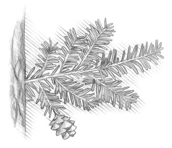
In 1963, bulldozers built firebreaks for a fire burning nearly 3,000 acres along the Iron Mountain crest. Today, the scars of the breaks and the fire have grown over. Big Laurel Branch Wilderness is completely covered with trees. Carolina hemlocks can be found in large stands, but most of the trees are mixed hardwoods. Grand views of Watauga and Wilbur lakes are seen from the top of the bluffs along the Appalachian Trail (AT). At a point about 1,000 feet above the lakes, boats appear as bathtub toys. This is very rugged country with no maintained trails.
[Fig. 29] Of the 150 miles of the Appalachian Trail within the northern CNF, 5.8 miles of the trail are within the Big Laurel Branch Wilderness Area. In the Watauga Lake area, the AT (#1) runs along the crest of Iron Mountain providing sensational vistas. The AT leads to the parallel crests at the southern end of Iron Mountain containing Big Laurel Valley and Little Laurel Valley, with no maintained trails leading into Big Laurel Valley. From Watauga Lake it is a steep walk on the AT to the crest of Iron Mountain, 1,400 feet elevation. Big Laurel Branch is one of many streams cutting into the rugged terrain.
About 13 miles along the AT from Watauga Dam Road look for an 8-foot monument.
This is the grave of a mountain man. The cracked plaque reads, "Uncle
Nick Grindstaff—born Dec. 26, 1851—died July 22, 1923—lived
alone, suffered alone, and died alone." He was a hermit, taking to the
hills at age 26 to live the rest of his life on Iron Mountain.

The AT in the wilderness area is rated Opportunity Class AT, which limits group size to a maximum of 10 people, limits organized groups to a maximum of 2, prohibits commercial outfitter/guide activities, and insists hikers practice leave no trace visiting. The CNF strives to limit the number of visible campsites to one or less per mile of trail within the wilderness area.
[Fig. 30(23)] Pond Mountain Wilderness Area, bound by Watauga Lake to the north, Dennis Cove Road (also called County Road 50, FR 50, and Laurel Fork Road) to the south, and FR 39 on the east, covers 6,668 acres in the Watauga District. Elevation ranges from a high of 4,329 feet on top of Pond Mountain to 1,900 feet at Laurel Fork Creek. U.S. Congress designated Pond Mountain Wilderness in 1986, incorporating the former Watauga Scenic Area.
Wilderness is managed to preserve its exceptional natural qualities. It is a place where humans are visitors, and natural physical and biological forces are allowed to proceed unrestricted by human activities. This is a place to find solitude and enjoy primitive and unconfined recreation.
This rough region has cliffs up to 200 feet high in the spectacular Laurel Fork Gorge and some old-growth forests that were inaccessible to loggers. In addition to the old-growth forest of scarlet oaks more than 100 years old found in the gorge, there are some cove hardwoods, but upland hardwoods make up the majority of the forests in the Pond Mountain Wilderness. Flame azalea (Rhododendron calendulaceum), mountain laurel (Kalmia latifloia), rhododendron (Rhododendron maximum), maple, beech, and hemlock are common here. The railroad bed that ran to Dennis Cove and was used for logging during the first two decades of the 1900s is now part of the AT that passes through the gorge. Birth dates of some timber stands range from 1861 to 1944.
Potato Top, a projection covered with trees and difficult to see if you aren't looking for it, got its name because it looks like a potato hill. It and Buckle Rock, a 150-foot-high cliff so named for its folded rock strata, are two popular features in the Laurel Fork Gorge. The slopes of Black Mountain to the south rise 1,000 feet from the gorge.
[Fig. 30(24)] The most popular scenic feature in the Pond Mountain Wilderness Area is Laurel Falls on Laurel Fork Creek. The segmented waterfall drops 45 to 55 feet and is probably the best known falls in this area. There is a large pool at the bottom suitable for swimming to those who enjoy cold mountain water. Laurel Fork Creek is also a good stream for fishing for wild rainbow and brown trout.
Upstream from Laurel Falls are Middle Laurel Falls (15- to 20-foot drop) and Upper Laurel Falls (15- to 25-foot drop). Between the Middle Laurel Falls and Upper Laurel Falls are Lower Dennis Cove Falls (10-foot drop) and Dennis Cove Falls (20- to 30-foot drop).
Dennis Cove Recreation Area, 5 miles east of Hampton on Dennis Cove Road, is a popular starting place for hiking to the waterfalls. After parking at the recreation area, go 0.8 mile west along Dennis Cove Road to where the AT crosses the road. There is a small parking area where the AT crosses the road but there is plenty of room to park at the recreation area. Follow the AT's white blazes to Laurel Falls.
[Fig. 30(25)] The Pond Mountain Trail (#40) is the only trail traversing the Pond Mountain Wilderness Area through its widest north/south dimension. The trail begins on US 321, entering the Pond Mountain Wilderness at the powerline crossing east of the Watauga Point Recreation Area. It rises to the crest of Pond Mountain (4,329 feet elevation) via a 4.5-mile trail and then descends to Dennis Cove along Rough Ridge. The initial climb is very steep, but the 1,800-foot rise in 1.5 miles offers a good view of the lake. Locals say, "It's as steep as a mule's face." Care is required to stay on this primitive trail because some turns are not marked. Maintenance of this trail conforms to the standard that only allows primitive, nonmechanized tools; therefore, it may be more primal than nonwilderness trails. Portions of this trail are rocky. The trail ends at FR 50 on the southern side of the wilderness east of Dennis Cove.
The Pond Mountain Trail is rated Opportunity Class II, which requires limiting group size to a maximum of six people, limiting organized groups to a maximum of two, prohibiting commercial outfitter/guide activities, and practicing leave no trace visiting.
[Fig. 30(26)] Along US 321, bordering the Pond Mountain Wilderness Area, are several recreation areas. Cardens Bluff Recreation Area on the south shore of Watauga Lake, north of the Pond Mountain Wilderness Area, is for single camping units only. No group or double sites are available. This camping facility, on a peninsula jutting into Watauga Lake, is a gated recreation area. Hiking and fishing are available to campers.
[Fig. 30(27)] The Cardens Bluff Trail (#55) is an easy hike along and above the shoreline of Watauga Lake for about half the length of the campground. The trail begins beyond the host campsite (#5) at the apex of a curve just beyond the parking area, and it ends on the west side of the peninsula near the restrooms. The walk offers good views and ample opportunities to fish.
[Fig. 30(28)] The Watauga Point Recreation Area is a day-use area only for picnicking, fishing, swimming, and hiking on the south shore of Watauga Lake.
The Watauga Point Trail (#59), an easy loop trail that is 0.41 mile long, begins at the parking lot on the right (east) near the entrance and follows the contours of the lake above the shoreline. The trail is gravel and offers some good views of the lake.
There are no trails designated for bicycles in the Watauga Ranger District, but bikes are allowed on some trails and roads. All forest roads (FR) open to motorized vehicles are open to bicycles, and all gated forest roads closed to motorized vehicles are open to bicycles unless signs specify they are closed to bicycles. Horse trails are open to bicycles.
No bicycles are allowed on the AT or blue-blazed foot trails (with some signed exceptions). There are more than 200 miles of forest roads in Carter, Johnson, and Sullivan counties, ranging from high-standard gravel to primitive.
In the Watauga Ranger District, the following roads are suggested routes for bicycles:
[Fig. 30(30)] The 1,783-acre Doe River Gorge Scenic Area lies south of Hampton and was designated in 1988, but the bottom of the gorge including the old railroad bed is privately owned. The trails leading into the gorge cross private land. The CNF boundary begins at an elevation of about 2,000 feet.
In 1868 workers began constructing a narrow-gage railroad to connect Johnson City, Tennessee, with Cranberry Iron Works near Elk Park, North Carolina. Completion in 1882 required hand-digging five tunnels and constructing trestles high over the Doe River. Laborers dug the tunnels with the aid of pack mules that had to be lifted over the ridges with pulleys because the cliffs of the gorge were too steep for the mules to climb.
The original purpose of the railroad was to haul iron ore from North Carolina to the furnaces in Johnson City. This line, East Tennessee and Western North Carolina, served many social functions as well. Isolated areas were connected to towns. The men who operated the train served as delivery men to people along the way, hauling items small and large and stopping to hand deliver them. Seven days a week the train ran, but it ran on a loose schedule. Anyone could hail the train, and it would stop to pick up passengers, to take orders or deliver goods, or to carry on a conversation. The line also hauled timber, supplies, and freight.
It is said some young ladies on their way to camp in North Carolina dubbed the line "the tweetsie" from the sound of the train's whistle. The name stuck, and is used today for an amusement park between Boone and Blowing Rock, North Carolina.
This 34-mile railroad suffered floods during the years of operation. Water roaring through the gorge washed out 39 places in 1901, and sections of the line were washed out again in 1904. Abandonment began then, but the railroad continued to operate, although less frequently, until 1975. During the early 1940s, the train operated three days a week, and by 1950 an abandonment request was filed and granted. A section of the line in the lower end of the gorge was rebuilt and operated by the Doe River Railroad Company for tourists until 1975.
On private land, the old railroad bed is the trail used in the lower end of the gorge, but the trail ends at an old trestle that is unsafe to walk. Permission and signing a release is required before hiking the trail. Hikers have fallen to their deaths from the rotten trestles. Do not attempt to cross one!
[Fig. 30(31)] The Doe River Gorge Trail (not a CNF trail) is on private land, but it is worth getting permission to see the wildflowers blooming along it in May. Dogwood (Cornus florida), rhododendron, jack-in-the-pulpit (Arisaeme triphyllum), fire pink (Silene virginica), and bleeding hearts (Dicentra cucullaria) will make your heart glad in the spring. The steep and shadowed gorge delays blooming. Due to the high humidity held between the steep cliffs, lush is the word most often used to describe this rain forest_like gorge. Anglers enjoy trout fishing, and swimmers love the clear, cool pools.
From the trailhead, enter a 200-foot tunnel dug by the railroad builders. About 0.7 mile along the trail is a camping spot near the Doe River. Farther along there is a 0.9-mile-long tunnel that leads to a sensational view of the Doe River. At the end of the tunnel, climb to the top of the rocks on the left (north) to get a good view of the ridgeline several hundred feet away. There you can see exposed folded rock strata.
[Fig. 30(32)] The Fork Mountain Trail (not a CNF trail) begins on private land across from the Fork Mountain Free Will Baptist Church parking lot, but hikers have been heretofore welcomed to walk on the trail. An old road is the trail that passes through new forest growth of sourwood (Oxydendrum arboreum) and maple in an area that was clear-cut in the 1970s. Farther along is an older forest of hardwoods that have grown since timber was cut in the early 1900s. A peak of 3,560 feet is reached about 1.2 miles along the road, and after the peak, the road dwindles to a trail.
In about another 500 feet the trail divides. The left trail leads steeply to the saddle between the two peaks of Fork Mountain, hence the mountain's name. The right trail leads through mountain laurel and rock outcroppings, ascends sharply to the other peak at an elevation of 3,615 feet, and offers a grand view. During the leafless seasons, the rim of Doe River Gorge is visible to the north, and Strawberry Mountain is visible to the south.
[Fig. 30(33)] The Laurels is a picnic area built by the Civilian Conservation Corps during the 1930s. This is a beautiful site with two pavilions, rockwork, and footbridges over Dry Creek.