 The
Southern Coast The
Southern Coast
The
Southern Coast The
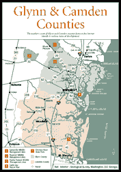
Southern Coast The southern coast of Glynn and Camden counties features five barrier islands in various states of development. Least developed are Little St. Simons Island and Cumberland Island National Seashore; moderately developed are Jekyll Island State Park and Little Cumberland; very developed are Sea Island and St. Simons Island. All have their charms. On the mainland are the towns of Brunswick and St. Marys, along with Crooked River State Park, several wildlife management areas, and two wild and beautiful blackwater rivers, the Satilla and St. Marys. Camden County and St. Marys are impacted by the Kings Bay Naval Submarine Base. The Okefenokee National Wildlife Refuge is covered in another chapter.
The southern coast is a fast-growing area. In 1990, Glynn County was the second most populated coastal county with 62,496 residents, with 14,000 on St. Simons and 16,433 in Brunswick. Glynn County is one of the eight original counties of Georgia, formed under Georgia's first Constitution in 1777. The county is named for John Glynn, a member of the British House of Commons who defended the cause of American colonies. Camden County had 30,167 residents, with 8,187 residents in St. Marys in the 1990 census.
Read and add comments about this page