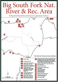
[Fig. 6] The Big South Fork National River and Recreation Area (BSFNRRA) is located in some of the most remote and rugged territory on the Cumberland Plateau. Its present size is approximately 115,000 acres, and it encompasses almost all of the drainage area of the Big South Fork of the Cumberland River. The Big South Fork originates in Tennessee at the confluence of the Clear Fork and New River, then flows down through a spectacular 600-foot-deep gorge before emptying into the Cumberland River in Kentucky below Cumberland Falls. Nearly two-thirds of the area lies in Tennessee, the remainder in Kentucky.
The sediments that form the layers of limestone, shale, coal, and sandstone
found along the Big South Fork were deposited when the area was covered with
a shallow sea more than 360 million years ago. Approximately 285 million years
ago, the area began a gradual rise to its present altitude of nearly 2,000
feet above sea level, in some areas.
The dramatic rock formations found at the BSFNRRA are the result of the erosion of underlying softer rock, while harder sandstone cap rock remains behind as arches, rock houses, and spires. The Big South Fork River continues to cut ever deeper into the ancient geologic past of the Cumberland Plateau, now cutting into sandstone deposits more than 320 million years old.
Along the lands bordering the rims of deep gorges, stands of red maple (Acer rubrum) blanket the plateau with splashes of brilliant red flowers each spring and yellow to red leaves each fall. Since most of the accessible timber was harvested prior to 1930 second-growth forests of oak, hickory, and Virginia pine (Pinus virginiana) compete for the broad flats.
The vegetation in the Big South Fork Gorge varies from rim to gorge with Virginia pine thriving in relatively dry soil, hemlocks (Tsuga canadensis) finding a niche beneath the rock bluffs on moist, northern slopes, and sycamore (Platanus occidentalis) lining the river's edges.
In the early spring, wildflowers found in the BSFNRRA include trout lily (Erythronium americanum), twinleaf (Jeffersonia diphylla), rue anemone (Thalictrum thalictroides), common cinquefoil (Potentilla simplex), trillium, and Dutchman's breeches (Dicentra cucullaris). In late spring (May), even more wildflowers add their grace to the rugged landscape. Jack-in-the-pulpit (Arisaema triphyllum), showy orchis (Orchis spectabilis), coreopsis (Coreopsis tinctoria), and Virginia bluebells (Mertensia virginica) are some of the best known. In June and July you can expect to see the brilliant orange hues of butterfly weed (Asclepias tuberosa) and flame azalea (Rhododendron calendulaceum). Black-eyed susan (Rudbeckia hirta) persists in August in some areas. Partridgeberry (Mitchella repens) and white snakeroot (Eupatorium rugosum) are also among the more than 40 species blooming.
In late summer and fall, the scarlets and soft lavenders of bergamot or bee balm (Monarda fistulosa) fill the spaces along sunlit paths. Goldenrod (Solidago sp.) and blazing star (Liatris scariosa) are among the fall bloomers. A checklist of wildflowers is available.
A large part of what makes the outdoors experience so rewarding is encountering wildlife in a natural habitat, on their own turf, so to speak. Visitors could see a bobcat, Tennessee's only surviving native cat, setting out in search of an evening meal on a warm summer evening. White-tailed deer (Odocoileus virginianus) tracks are ubiquitous along moist edges of clearings and game trails after recent rains. Spotting deer grazing around an old homestead creates a lasting vision of the uplands of Big South Fork country for most visitors. Black bears are also sighted within the BSFNRRA.
It's an unexpected delight to come across the sleek river otter (Lutra
canadensis) at river's edge. Opossum (Didelphis virginiana), wild
boar (Sus scrofa), fox squirrel (Sciurus niger), mink (Mustela
vison), and coyote (Canis latrans) are among the more than 50
animal species inhabiting the Big South Fork area. Wildlife in the BSFNRRA
is of special interest to anglers and hunters. Hunting has taken place here
for centuries, and in this setting a balance is maintained between hunters,
wildlife populations, and habitat. The area offers legal hunting in accordance
with state regulations.
This region will please any bird watcher. Permanent residents like the great blue heron (Ardea herodias) and belted kingfisher (Megaceryle alcyon) are spotted fishing along creeks and rivers, while sharp-shinned (Accipiter striatus) and red-tailed hawks (Buteo jamaicensis) keep a sharp eye out from above. Neotropical migrants like the yellow billed cuckoo (Coccyzus americanus), whip-poor-will (Caprimulgus vociferus), wood thrush (Hylocichla mustelina), and acadian flycatcher (Empidonax virescens) stop here before migrating to the tropics for the winter. A checklist of birds, their habitats, and seasons of occurrence is available at the Bandy Creek Visitor Center.
The BSFNRRA is believed to contain thousands of archaeological sites, some pointing to the presence of humans in the large rock houses and caves around 12,000 years ago during the Paleo-Indian period.
The first white men to penetrate the region were the longhunters in the late 1700s. Among such longhunters was a man born in Virginia in 1779 named Jonathan Blevins. Blevins settled first in Kentucky before establishing his home on Station Camp Creek. Jonathan Blevins' grave is located on Station Camp Creek about 2 miles from Charit Creek Lodge.
The upland farm of his descendant, Oscar Blevins, may be visited on the Oscar Blevins Farm Loop Trail in the Bandy Creek area. In addition to subsistence ridgetop farms, early settlement in the Big South Fork area tended to be concentrated in river and stream basins in communities like No Business and Station Camp. Later, emphasis shifted to lumber and mining communities with additional settlement along roadways.
In time, a few settlers developed farming operations, but the area remained sparsely settled due to its rugged terrain. The arrival of the railroad in 1880 brought rapid, widespread changes. Dozens of mining and lumber operations sprang up in the watershed, creating an economic boom that was no longer based on subsistence farming and barter. The first commercial oil well in the United States was said to be accidentally drilled here in 1818 during a search for salt water. Limited oil and gas production continue in the BSFNRRA, now primarily in the area adjacent to the southern rim.
After the timber was exhausted, many families left their homesteads and found work as wage earners in company towns like Stearns, Kentucky. One of the mines owned by the Stearns Company, the Blue Heron Mine, opened in 1937 and operated until 1962. Today, the Blue Heron mining camp has been re-created and the Blue Heron Outdoor Historical Museum features exhibits that tell the story of coal mining and logging in the Big South Fork River area.
Coal mining peaked in the area in the 1930s. The next decade brought declines in production and employment that forced many families to leave the Big South Fork area in order to find employment.
In the 1930s, a narrow rapids in the Kentucky part of the Big South Fork known as Devil's Jump was considered by the Tennessee Valley Authority (TVA) as the site for construction of the tallest dam east of the Rockies. The dam would have created a 37,000-acre reservoir for recreation and flood control with a 480,000-kilowatt generation capacity, significantly more than any other facility in the Southeast.
Although funding for the project was repeatedly approved in Public Works Bills in the United States Senate, the bills failed to gain approval each time in the House of Representatives. Local conservationists remained firmly opposed to the project and looked for alternatives to protect the Big South Fork while providing a much-needed economic stimulus for the area.
The conservationists in the Tennessee Citizens for Wilderness Planning (TCWP) first tried to stop the proposed dam at Devil's Jump by having the Big South Fork included in the Tennessee Scenic Rivers Bill, but when the legislation passed in 1968 the river had been deleted from the list.
TCWP also managed to have the Big South Fork included in the list for the national Scenic Rivers Bill, but again the river was taken off the list before the bill passed.
Eventually, the efforts of the TCWP, a coalition of additional conservation groups known as the Big South Fork Coalition (BSFC), Tennessee Senator Albert Gore Sr., the United States Army Corps of Engineers, the Department of the Interior, and U.S. Senator Howard Baker found a creative alternative that established a national river and recreation area, protecting the wilderness in the Big South Fork Gorge while providing increased access for recreation in adjacent areas.
The Big South Fork National River and Recreation Area was authorized by the Water Resources Development Act of 1974 as amended by Section 184 of the Water Resources Development Act of 1976 "for the purposes of conserving and interpreting an area containing unique cultural, historic, geologic, fish and wildlife, archeologic, scenic and recreational values." In a very unusual arrangement, the BSFNRRA was developed and constructed by the U.S. Army Corps of Engineers and subsequently turned over to the U.S. Department of the Interior for operation and management.
Because management guidelines in a national recreation area are less restrictive than in a national park, visitors to BSFNRRA may enjoy traditional park activities such as hiking, horseback riding, and primitive camping as well as nontraditional activities including four-wheel driving, hunting, and trapping. Among other activities that can be enjoyed are backpacking, bicycling, canoeing, fishing, kayaking, participating in nature programs, nature walking, picnicking, rapelling, recreational vehicle camping, rock climbing, sight seeing, scuba diving, snorkeling, swimming, and whitewater rafting. Information about these activities is available at the Bandy Creek Visitor Center.
[Fig. 6(9)] First-time visitors will find information on all aspects of the BSFNRRA at the Bandy Creek Visitor Center. In addition to printed guidelines on BSFNRRA activities and the wealth of information offered by friendly park rangers, the book shop has maps, trail guides, and books about the area. This is also the location of public restrooms and the adjacent Bandy Creek Campground, which offers more than 180 campsites. Facilities include developed campsites with hookups for RVs, tent sites, bathhouses, a swimming pool, and services that include stables for boarding horses. The visitor center is on eastern standard time. Although portions of the BSFNRRA are within the central daylight time zone, the entire park functions on eastern standard time for simplification. Interstates 40 and 75 provide access to the area.
[Fig.
7(3)] The Blue Heron Mining Community is an abandoned coal mine operated
by the Stearns Company from 1937 until it was closed in 1962. When production
ceased, the buildings were either removed by the company or left to decay.
By the time the BSFNRRA was formed, there were no original structures remaining
other than the coal tipple, a structure designed to receive coal from mines
on both sides of the river and sort it by size into various grades before shipping
it out on railroad cars. The U.S. Army Corps of Engineers re-created the location
as an interpretive center in the 1980s.
Visitors taking the tour of the complex see a representation of the mining village including the homes, school, and church of Blue Heron as well as one of the entrances to Blue Heron, or Mine 18.
Today there is a paved road to the site as well as a train depot that serves as a landing platform for visitors arriving on the Big South Fork Scenic Railway from Stearns, Kentucky.
The Big South Fork Scenic Railway is an open-air excursion train that travels to Blue Heron from Stearns on the original K&T Railroad line Wednesday through Sunday from May through October, with additional trains running in late April and during the October fall foliage season.
Passengers are loaded first-come, first-serve for the 3-hour, 13-mile round trip. Call (800) GO-ALONG for more information. The Whistle Stop Cafe beside the depot serves breakfast, lunch, and dinner on the days the train is running.
[Fig. 7(3)]
[Fig. 7(20)] Visitors wishing to enjoy the beauty of the BSFNRRA and primitive accommodations seek reservations at Charit Creek Lodge. It is nestled in a remote wilderness location where Charit Creek joins Station Camp Creek in a small valley framed by high bluffs accessible only on foot or by horseback.
The structure has evolved through the years of habitation, and on the western end there is a log cabin that may have been built in the early 1800s by longhunter Jonathan Blevins. The house became a hunting lodge known locally as "the hog farm" due to the Russian boar imported by owner Joe Simpson in the early 1960s. It was also operated as a youth hostel from 1987 to 1989. Today it's operated by the same folks who operate another well-known Tennessee wilderness retreat, Le Conte Lodge in the Great Smoky Mountains National Park.
There is running water at the lodge, but no electricity. Each room is equipped
with a kerosene lamp and a wood stove. The shower water is heated by solar
energy and screened windows and doors provide air conditioning in the summer.
There's also a horse stable and you're likely to see groups of riders while
you're here. Dinner and breakfast, complete with steaming mugs of coffee, are
served. Reservations are needed and you'll receive details on trail choices
and directions with your reservation.

[Fig. 7(21)] Several switchbacks, a long set of steps, and some stairs aid you on the short, steep, downhill trek to Charit Creek Lodge. In season, you'll see clusters of the delicate rue anemone (Anemonella thalictroides), along with chickweed (Stellaria media) and trillium (Trillium spp.) as the path winds along moist slopes to the stream crossing at Station Camp Creek in front of the lodge.
Charit Creek may have been named for a young girl named Charity who drowned in the creek.
[Fig. 6(5)] The Leatherwood Ford is a popular spot on the Big South Fork offering swimming, picnicking, fishing, and interpretive nature trails. There's an easy put-in for canoes with a low-water bridge providing good access to both sides of the river for bank fishermen and hikers. Those who enjoy playing in the water find this a good spot much of the time since the river is often wide, shallow, and gently rippling at this point. Handicapped-accessible boardwalks with benches and footbridges follow the river's edge.
[Fig.
6(6)] There are several scenic overlooks and rock bluffs along this
trail, as well as access to the fantastic Leatherwood Ford Overlook.
The trail leads from the rim to the river and back via switchbacks and steps.
You may
begin your loop at the parking area for the Leatherwood Ford Overlook
and Sunset Overlook and descend to the river or begin at the river at the
Leatherwood
Ford Trailhead below the TN 297 bridge that spans the Big South Fork
and climb to the East Rim. The Leatherwood Ford Trail briefly joins the John
Muir Trail along the river before it begins its steady ascent. The
moist slopes lining the river are good spots for spring wildflowers
in April and May.
[Fig. 6(1)] The Alum Ford area is popular for its boat-launching ramp, which gives anglers with power boats access to the river that now flows into Lake Cumberland. People interested in an alternative to RV camping will enjoy primitive camping here at sites with picnic tables. The Yahoo Falls Trails are nearby as well as access to the Sheltowee Trace National Recreation Trail.
[Fig. 6(2)] Yahoo Falls, the tallest waterfall in the BSFNRRA, drops 113 feet as Yahoo Creek tumbles over a gigantic rock shelter. The well-maintained Topside Loop Trail leads from the parking lot at the Yahoo Falls Scenic Area past several overlooks on the way to the top of the falls. Two trails, Cascade (a 1.1-mile loop with blue blazes) and Cliffside (a 1.2-mile loop with green blazes), spur off the Topside Loop (a 1.1-mile loop with yellow blazes). The Cascade Loop follows a portion of the Sheltowee Trace National Recreation Trail and Cliffside leads to the base of the falls.
The extensive trail system within the BSFNRRA provides hikers with access to virtually all of the scenic and historic locations and accommodates all ages and levels of experience. Some trails can be walked in less than one hour, while others require a full day or longer, and the degree of difficulty ranges from easy to strenuous, with many of the trails falling in the moderate to strenuous category as a result of length or topography. Due to the presence of high cliffs and the generally rugged nature of the trails, it is recommended that hikers plan to reach their destination well in advance of nightfall. Rain, snow, and ice also increase the difficulty of the trails, making some of them extremely hazardous.
These trails are listed from south to north through the BSFNRRA.

[Fig. 6(17)] Bluffs, rapids, and large boulders are seen along this loop which joins the John Muir Trail as it follows the Clear Fork River, a favored destination for rafters and canoeists. A profusion of wildflowers line the trail in the spring and there are a couple of favorable camping spots along the way.
[Fig. 6(18)] This is a rugged and strenuous walk involving climbing ladders enclosed in wire, crossing multiple streams, and scrambling over boulders. The trail is very popular with hikers. Along its length the traveler will be pleasantly surprised to see Honey Creek Falls, Moonshine Falls, Hideout Falls, and Boulder House Falls, rock formations, Indian rock shelters, massive boulders, and a series of Class III and IV rapids. Much of the trail passes through what was the Honey Creek Natural Area, a 109-acre pocket wilderness established by Bowater, Inc. prior to the area's incorporation into the BSFNRRA.
[Fig. 6(10)] The East Rim Overlook is wheelchair accessible via a paved walkway and provides a scenic overlook 400 feet above the river. A camera with a 200mm lens or larger will provide better details of bluffs and the river below. Retrace your way on the paved portion of the trail or take the short graveled section back to the parking lot.
[Fig. 6(11)] This trail passes small ponds, leads past a shooting range, and follows a small stream along the ridge on the way to an overlook that provides a nice view of the Big South Fork River gorge from a bare rock bluff.
[Fig. 6(5)] The O&W Bridge Trail follows the river, crosses streams, offers nice views of river bluffs, showcases seasonal wildflower displays, and includes the opportunity to walk across the historic O&W Railroad Bridge. The O&W linked the area with the rest of the world via the O&W Railroad, which carried logs, coal, passengers, and mail between depots in Jamestown and Oneida. Operation of the line ceased in 1954.
[Fig.
6(6)] This pleasant, level walk features a continuous view of the Big
South Fork River, impressive rock bluffs, and Angel Falls. Once an 8-foot cascade
that was dynamited in an effort to improve navigation along this section of
the river, Angel Falls is now a dangerous Class III or IV rapid. A brochure
available at the Bandy Creek Visitor Center or the gazebo at Leatherwood Ford
identifies 30 numbered trees along the trail. The trees range from red mulberry
(Morus rubra) and umbrella magnolia (Magnolia tripetala) to sassafras
(Sassafras albidum) and shagbark hickory (Carya ovata). This
is also a good wildflower trail with opportunities for spotting the lovely
pink lady's slippers (Cypripedium acaule) blooming, usually around Mother's
Day.
[Fig. 6(3)] This trail leads along the west bank of the Big South Fork River and crosses Fall Branch before climbing to the top of a ridge for one of the best scenic views of the Big South Fork River gorge. Hikers should be prepared for steps, a ladder, sheer ledges, and switchbacks. This trail is a portion of the John Muir Trail.
[Fig. 6(3)] The Grand Gap Loop Trail picks up at the end of the Angel Falls Overlook Trail (see above). The loop is 6.8 miles, but reaching it adds 3 or more additional miles since the loop can only be reached via connecting trails. Access from Leatherwood Ford via the Angel Falls Overlook Trail involves a 12.8-mile round trip. Hardwood forests, high cliffs, and overlooks of the Big South Fork and Angel Falls highlight the Grand Gap Loop.
[Fig. 6(7)] Highlights of this trail include rock houses, Fall Branch Falls, and a log house and barn built along a creek in a small cove by John Litton around 1900. The household of General (his name, not his rank) Slavens was the only other family to live on this farm before it was purchased for the BSFNRRA in 1979.
[Fig. 6(9)] This is a good trail for hikers not up to strenuous climbs up rock ledges or ladders, but wanting a chance to become familiar with the campground and its facilities. This brisk walk in the woods offers the chance to spot birds and occasional deer.
[Fig.
6(10)] A brochure available at the Bandy Creek Visitor Center or from
a box near the trailhead discusses plant succession taking place in
fields along the trail. The trail passes through fields reclaimed by native
grasses,
woody plants, and Virginia pine before passing through a forest of
poplar, oak, and maple. The honeycombing found on sandstone is explained
as the result
of differential erosion, a process that leaves behind less erosive
materials like mineral deposits and erodes the surrounding sandstone. Evidence
shows
rock shelters along the path were used by prehistoric visitors 8,000
to 10,000 years ago and more recently as animal pens. The Oscar Blevins homestead
consists
of a log house built in the 1890s and a frame house built in the 1950s.
The Blevins family descended from Longhunter Jonathan Blevins.

[Fig. 6(4)] This trail follows an old logging road along much of its length and intersects the Oscar Blevins Farm Loop Trail after several stream crossings. During May and June hikers may find mountain laurel and rosebay rhododendron in bloom.
[Fig. 7(18)] This trail travels through an upland hardwood forest and across rock bluffs before reaching the first large rock shelter. The sandy soil and huge boulders inside rock shelters are the result of water and weathering. Important to prehistoric peoples as well as Indians and early settlers, the rock shelters are also home to a rare plant listed as threatened in Tennessee and Kentucky. Lucy Braun's snakeroot (Eupaterium Luciae Brauniae) grows to a maximum height of 3 feet with triangular serrated leaves and tiny tubular white flowers on a stalk at the top of the plant.
[Fig. 7(18)] At 1.1 miles, this trail intersects with the Mill Creek Trail. Take this spur trail to see Slave Falls, named for the runaway slaves local legends say once took refuge in the area, and Needle Arch, a sandstone formation molded by runoff and seepage. Back on the Slave Falls Loop Trail, hikers will see Indian Rock House, which at 75 feet deep and nearly 100 feet wide is one of the largest rock shelters in the park.
[Fig. 7(18)] Hikers travel along an old railroad bed about 1 mile past the Hattie Blevins Cemetery before joining a 5-mile segment of the John Muir Trail. The John Muir Trail (JMT) joins the Sheltowee Trace National Recreation Trail and heads up Rock Creek, descending to the creek at a couple of areas deep enough to make nice swimming holes. After the JMT and Sheltowee Trace National Recreation Trail turn to the right, the Rock Creek Loop Trail continues left up a steep path.
[Fig. 7(10)] The Twin Arches Trail leads to the Twin Arches, massive side-by-side natural bridges that are among the most impressive geological features in Tennessee. The North Arch spans 93 feet and rises 62 feet. The South Arch spans 135 feet and rises 103 feet. Taken together, they are among the largest natural bridges in the world. A steep stairway between the two arches leads to the top.
[Fig. 7(10)] Despite being a strenuous walk, the Twin Arches Loop Trail is one of the most popular in the BSFNRRA because it provides access to the magnificent sandstone formations known as Twin Arches and Charit Creek Lodge, a historic site and wilderness accommodation for backpackers and horse trail riders. Along the way, the trail also passes rock shelters and the sandstone chimney marking the homesite known as Jake's Place, which was named for Jake Blevins, descendant of Longhunter Jonathan Blevins. The Twin Arches Loop Trail is reached by several trails, including the Twin Arches Trail.
[Fig. 6(15)] There are many interesting features on this trail, including historic Laurel Dale Cemetery across from the trailhead. The cemetery contains graves of early members of the Victorian colony at Rugby, including Margaret Hughes, the mother of the founder. The turn-off to the Gentlemen's Swimming Hole is 0.4 mile from the trailhead. This popular swimming hole is where only the men from Rugby frolicked in the Clear Fork River, but today everyone enjoys a dip followed by a picnic on a hot summer day. Along the way, a rock shelter known locally as Witch's Cave and spring wildflowers including trailing arbutus (Epigaea repens), wild geranium (Geranium maculatum), crested dwarf iris (Iris cristana), and little brown jugs (Hexastylis arifolia) may be seen. The trail continues to the Meeting of the Waters, the confluence of the Clear Fork River and White Oak Creek. A brochure prepared by Historic Rugby and the National Park Service available from the visitor centers at Bandy Creek in the BSFNRRA or the Rugby Schoolhouse warns hikers to beware of timber rattlers, copperheads, ticks, and poison ivy.
[Fig. 7(3)] This trail features scenic overlooks, including one known as Devil's Jump. A portion of the trail that is paved but steep in spots begins about 0.5 mile along the Blue Heron Loop Trail. This portion may be accessed at a parking lot past the one containing the trailhead. The portion accessed from the trailhead in the first parking lot is also paved and is a bit more gentle for those searching for handicapped-accessible trails. The trail passes wildflowers, a rock house, and other geologic formations like Cracks-in-the-Rock, giant rock slabs along the rock bluff joined by narrow stairs. The trail also passes through the historic mining community at Blue Heron.
Directions: In Oneida go north on US 27 and continue to KY 1651 at Pine Knot, KY. Turn left on KY 1651 and drive to Revelo. Turn right on KY 742 at Revelo and turn right (west) in 3.2 miles on Mine 18 Road. Pass the campground on the right and turn left on the Overlooks Road that leads to Blue Heron. The trailhead is at the end of the first parking area but a second paved portion of the trail may also be accessed from the next parking lot on the road leading to the overlooks.
[Fig. 7(4)] The Catawba Overlook provides a scenic view of the Big South Fork River gorge, but the trail to the overlook can be marshy in spots after a rain and requires several creek crossings. In addition to the Catawba rhododendron found at the overlook, wildflowers may be seen along the way.
[Fig. 7(1)] The name, Sheltowee, means big turtle in Shawnee, and it is a name frontiersman Daniel Boone was given after being captured by the Indians while on a supply mission from Boonesborough to where his men were making salt at Blue Licks. The turtle is the identifying blaze on much of the trail.
Accessed at Pickett CCC Memorial State Park via the Hidden Passage trailhead, the trail leads past waterfalls, rock shelters, creeks, abandoned mines, railroad trestles, and backcountry camping spots. At the Kentucky state line the trail enters the Daniel Boone National Forest, then swings east and runs along the BSFNRRA boundary, following the Laurel Ridge Road. The trail continues past natural stone arches, campgrounds, picnic areas, waterfalls, river access points, and rock shelters. It departs the BSFNRRA, heading northward through the Daniel Boone Forest, then enters the BSFNRRA again near the Yamacraw Bridge. This bridge crosses the Big South Fork River near a day-use area off KY 92. Local outfitters describe the river run from Yamacraw Bridge to Alum Ford as easy, or Class I. The trail exits the BSFNRRA for the last time at the headwaters of Lake Cumberland after passing through the Yahoo Falls Scenic Area.
Portions of the Sheltowee Trace National Recreation Trail north of Cumberland Falls, Kentucky, lie on roads, some of which are open to both off-road vehicles and horses. There are many places where the trail can be accessed, so hikes of whatever length desired can be planned. However, hikers contemplating long trips are urged to obtain up-to-date information from the Stearns Ranger District, POB 429, Whitley City, Kentucky 42653, phone (606) 376-5073.
[Fig. 7(14)] Named for naturalist and conservationist John Muir (1838_1914), this is one of Tennessee's State Scenic Trails, which, when completed, will extend from Pickett State Park on the Cumberland Plateau to the Appalachian Trail in the southern part of the Cherokee National Forest. At the present time, right-of-way problems stand in the way of connecting the widely separated segments. The trail commemorates the 1867 hike through the plateau by Muir, a conservationist and founder and president of the Sierra Club until his death in 1914.
The western portion of the John Muir Trail (JMT) begins at the Hidden Passage trailhead in Pickett CCC Memorial State Park and follows Thompson Creek to a junction with the Sheltowee Trace National Recreation Trail near the Kentucky state line. JMT turns south, then west, back to the southeast, and eventually reaches the Big South Fork River. It follows the river to the Leatherwood Ford Bridge where a short section of the JMT is handicapped accessible. The JMT continues to the old O&W Bridge where it stops until construction is completed. An additional segment to Honey Creek has been partially staked but is not completed at this writing. An 18-mile southern portion of the trail is in the Cherokee National Forest near the Hiwassee State Scenic River.
Arches, or natural bridges, are most often created in the exposed cliffs and ridges of the plateau when the softer rock under the highly resistant sandstone cap erodes. In and around the BSFNRRA there are well over two dozen of these features.
[Fig. 7(10)] The best known arches in the BSFNRRA are the Twin Arches, which are accessible on the Twin Arches Trail. The Twin Arches are two of the largest arches in the eastern United States. Steps lead up and across the span.
[Fig. 7(18)] Needle Arch is a thin, delicate arch that was left standing alone when the back of the rock shelter of which it was once a part eroded. It can be reached from the Slave Falls Loop Trail. At 1.1 miles along the trail, the Slave Falls Loop Trail turns right to Slave Falls, but go straight on the Mill Creek Trail that leads to Needle Arch.
[Fig. 7(6)] Split Bow Arch is a narrow rock bridge that remained when large chunks of rock eroded and fell from a section of the rock bluff. The arch can be seen from an overlook or a 0.7-mile loop trail leads to and through the arch. The honeycomb rock seen here is formed when groundwater seeps through sandstone, dissolving the iron deposits out of the formation and leaving behind the sandstone.
[Fig. 6(2)] Yahoo Arch is another arch formed by erosion at the back of a rock shelter. The 15-foot-high arch with a 60-foot span can be reached from the Yahoo Falls Scenic Area just off KY 700.
[Fig. 7(7)] Koger Arch is a broad arch resulting from rock shelter erosion. With a clearance of 18 feet, it spans 91 feet. It is accessible from the Sheltowee Trace National Recreation Trail and also from a short trail leading up from Devils Creek Road near the Yamacraw area.
[Fig. 7(11)] Buffalo Arch is also accessible from the Sheltowee Trace National Recreation Trail near the BSFNRRA/Daniel Boone National Forest boundary on Rock Creek. Buffalo Arch comes out of the hillside, spanning 82 feet and clearing 19 feet.
Although camping is allowed throughout much of the backcountry accessible by horse trails, BSFNRRA requests that horses be tied on picket lines away from water, trees, and buildings, and all camps should be away from marked safety zones or trails. In addition to the stables at Bandy Creek and facilities for horses at Charit Creek Lodge, there are developed horse camps in both the Kentucky and Tennessee portions of BSFNRRA. Horses must have current proof of a negative Coggins Test for swamp fever.
[Fig. 7(5)] The Bear Creek Horse Camp, operated by a National Park Service concessionaire, services the northern BSFNRRA from its base outside Stearns, Kentucky, but make reservations and inquiries through Oneida in the southern portion of the area.
[Fig. 7(22)] The Station Camp Horse Camp, also operated by a National Park Service concessionaire, services the northern BSFNRRA. It's a good idea to call for reservations at this popular camp west of Oneida.
The more than 180 miles of horse trails throughout BSFNRRA are marked with a white blaze and a yellow horse head. Some portions of trails are shared by hikers, horses, mountain bikers, all-terrain vehicles (ATVs), and four-by-four vehicles. Although mountain bikes are permitted on horse trails, cyclists are urged to yield to horses and encouraged to remain stationary as horses pass. Horseback riding is forbidden on paved roads and hiking trails not specifically designated for equestrian traffic. Horses, like hikers, are encouraged to stay on the trail because taking short cuts on switchbacks creates paths devoid of vegetation and subject to erosion. To prevent damage to trees, horses should never be directly tied to trees, even for short breaks.
[Fig. 7(8)] This route features upland forests and level to gentle hills with a steep descent to the Big South Fork River at Blue Heron.
[Fig. 7(2)] This trail features upland forests, Peter's Mountain, and the Blue Heron Mining Community. The trail crosses streams with a ford at the Big South Fork River at Blue Heron.
[Fig. 6(9)] Overlooks, upland forests, old farmlands, and level to gentle hills provide a pleasant ride on this loop trail.
[Fig. 6(9), Fig. 7(20)] The trail crosses Laurel Fork Creek, passes Charit Creek Lodge, and makes steep descents into Laurel Fork and Station Camp creeks.
[Fig. 6(9)] The trail passes through upland forests on a route that encounters only gentle hills.
[Fig. 6(9)] This ride features abandoned farmlands, upland forests, and a steep descent to Laurel Fork Creek before reaching Station Camp Creek.
[Fig. 7(12)] This trail features a wooded ridgetop, a 1930s railroad grade, a steep descent to the Laurel Fork Creek, and the Big South Fork River.
[Fig. 7(13)] The route provides views of old homesites, rock shelters, the Big South Fork River, and wildflowers. There are some steep climbs out of the river gorges. Caution and sound judgment should be used before attempting to ford river at Station Camp East or Big Island at No Business Creek. If in doubt, don't.
[Fig. 7(16)] This is a beautiful trip along Station Camp Creek, past old abandoned homesites, and along the Big South Fork River. There are some creek crossings.
[Fig. 7(19)] This trail has magnificent overlooks of Charit Creek Lodge, Station Camp Gorge, and the Big South Fork River. The trail has a steep descent into the river gorge.
Hunters, hikers, mountain bikers, horseback riders, backpackers, and paddlers enjoy roughing it in the backcountry of the BSFNRRA. Although backcountry permits are not required, it is a very good idea for campers to register with the ranger station. Doing so helps the recreation area evaluate backcountry use and locate individuals or parties in case of an emergency. Permits and full information regarding backcountry camping can be obtained from the Bandy Creek Visitor Center.
There are no designated backcountry sites, but existing sites have evolved through repeated use. Camping is allowed in much of the backcountry. Exceptions include areas within 25 feet of a cave, rock house, cemetery, historic site, or the rim of the gorge, or in the path of any trail, roadway, or parking area.
Dead and down trees may be collected for campfires unless temporary restrictions are in effect. Campfires are not allowed in rock shelters, under arches, or near historic structures at any time.
The Big South Fork of the Cumberland River and its major tributaries, Clear Fork, North White Oak, and New River, offer a variety of experiences for canoeing, kayaking, and rafting. Some of the stretches are placid enough for new paddlers, while others require skilled whitewater paddling, so make sure you're competent to handle yourself and your craft from put-in to take-out. The limited access warrants underestimating rather than overestimating your skills and thoroughly researching the area you plan to float.
When water levels are high and the flow rate is increased, the river can be dangerous regardless of the paddlers' experience. Floatation devices should be worn by everyone who floats the river. Helmets should be worn by all kayakers and by open canoeists on Class III and above rapids. The park suggests packing a spare paddle, a throw rope, a bailer, and a first aid kit. All supplies should be secured.
For more information such as current river conditions, flow rates, and available commercial operators may be obtained by calling the Bandy Creek Visitor Center, phone (931) 879-3625.
[Fig. 6(13)] The first 6 miles of the New River are fairly easy paddling, but the next 2 miles have some Class II_III ledges, proving why this is not a beginner's float. The final 7.5 miles are run on the Big South Fork River, which contains several Class III_IV drops. The trip requires enough stamina for a long day of paddling with challenges increasing as the float progresses.
[Fig. 6(12)] North White Oak Creek is an 8-mile run through short rapids requiring good maneuvering skills. The gorge is lined thickly with second growth including laurel, rhododendron, and hemlock at the base of 400-foot bluffs. Boulders of assorted sizes and shapes must be navigated. This stretch is characterized by low water and is only floatable after rain.
[Fig. 8(3)] This is a nice trip for paddlers who know basic canoe strokes and come when there's enough water to run it. Laurel thickets cloak the steep valley walls as the Clear Fork River starts to cut into the Cumberland Plateau. The river is characterized by long, slow segments and short, easy drops.
Directions: The Peters Ford Bridge Road leaves TN 52 at Pleasant View Church of the Nazarene 3 miles east of Allardt and 8 miles east of Jamestown. Turn south on Peters Ford Bridge Road and drive about 5 miles to the access point at Peters Ford Bridge.
[Fig. 6(14)] This is a very beautiful section featuring rapids with high, irregular waves capable of swamping an open canoe. Some may require scouting from shore and the ability to read water. Paddlers should be capable of whitewater maneuvers.
The only named rapid in this section is Decapitation Fork, formed where the stream passes beneath an undercut rock. Though not particularly dangerous, it requires some maneuvering to navigate.
Those who are tempted to go beyond Burnt Mill Bridge should know the river quickly becomes challenging for expert and advanced canoeists. It features Double Falls with two tumultuous 4-foot drops, Washing Machine which drops into a swirling, boulder-lined pool, and The Ell with its complicated drop. All three rapids are found in a single 200-yard section and more wait downstream.
[Fig. 6(16)] White Oak Creek passes rock houses and scenic bluffs as it heads for the Clear Fork River. The last 0.5 mile of the creek has some Class II rapids, but the float down the Clear Fork River to Burnt Mill Bridge has no major rapids to distract from the surrounding beauty.
[Fig. 6(17)] This is the primary whitewater stretch in the BSFNRRA and is one of the best whitewater runs in the Southeast. It should only be run in the spring when water flow is adequate, and it should only be attempted by those with the proper equipment and experience.
[Fig. 6(5)] This two-day run combines fairly frequent rapids with easy-to-read water and spectacular fall color during October. There are two drops that should be portaged. The first is Angel Falls, 2 miles below Leatherwood, and it should be portaged on the right. Devils Jump, another boulder jam, is located just above the take-out point and should be portaged on the left.
Bikes are not allowed on hiking trails that are blazed with red arrowheads, but bikes share equestrian trails that have a yellow horsehead blaze, although horses have priority. Bikers should stop to let horses pass by to minimize confusion.
It's a good idea to leave your travel plans with someone and you should always wear a helmet. Park rangers recommend carrying your bike over boggy, muddy areas to minimize trail damage.
There are two designated mountain bike trails accessible from the Bandy Creek Visitor Center, the Duncan Hollow Bike Trail and the Collier Ridge Bike Loop. A map of the trails and other information is available at the visitor center.
[Fig. 6(9)] An old farm site, wooded areas, and a creek crossing are along the route to Station Camp Creek. Portions of the trail are shared with horses.
[Fig. 6(9)] This trail goes by the Katie Blevins Cemetery which is the final resting place of Jacob Blevins, son of early settler Jonathan Blevins and husband of Katie. It crosses the Oscar Blevins Trail, North Bandy Creek, King Branch, and South Bandy Creek, winds through the woods, follows TN 297 for 1.4 miles, and returns to the Bandy Creek trailhead after crossing North Bandy Creek again. It crosses horse trails, and short portions are shared with hikers.
ATVs, off-road motorcycles, dune buggies, and other off-road vehicles are allowed in the BSFNRRA under certain conditions. In general, the river gorge area is off limits to motorized intrusion and the ridgetop roads are open to multiple use. Multiple use theoretically includes off-road vehicles, but accessible areas are changing as road use is redefined so it's always best to check with the visitor center. A copy of current regulations for Tennessee and Kentucky can be obtained from the Bandy Creek Visitor Center.
The Big South Fork and its tributaries provide an immense amount of fishing potential for both warm-water and cold-water species. Some parts of the rivers and streams can be reached by automobile or four-wheel-drive vehicle. However, the major part of the system is accessible only on foot or by floating in rafts or canoes. In total there are well over 200 miles of productive water available.
Some species are prevalent from the headwaters to where the Big South Fork leaves the area, while others, notably rainbow trout (Salmo gairdneri) and brown trout (Salmo trutta), are found only in the higher elevation streams. Neither species is native. They are present in Williams Creek, Laurel Fork, and Station Camp Creek on the upper reaches of the river.
Smallmouth bass (Micropterus dolomieui), walleye (Stizostedion vitreum vitreum), muskies (Esox masquinongy), catfish (Ictalurus punctatus), and bluegill (Lepomis macrochirus) are found the entire length of the river, and on the extreme lower reaches, sauger (Stizostedion canadense), largemouth bass (Micropterus salmoides), and white bass (Roccus chrysops) occur. These is also a late winter spawning run of walleye from Lake Cumberland that produces some specimens larger than those found year-round in the river.
Fishing licenses from either Tennessee or Kentucky are recognized from Leatherwood Ford Bridge down to the Yamacraw Bridge on the Big South Fork of the Cumberland River. Anglers must follow the regulations of the state in the which the license was issued. However, this reciprocal agreement does not extend to tributary streams. For copies of fishing regulations, contact the Tennessee Wildlife Resource Agency (615-781-6500) or Kentucky Fish and Wildlife Resources (502-564-4336).
The legislation that created the BSFNRRA authorized hunting, which is conducted in accordance with state and federal regulations. Once a favored hunting ground for the Indians who made frequent forays into the territory seeking buffalo (Bison bison), elk (Cervus elaphus), white-tailed deer, black bear (Ursus americanus), and other furbearers for meat and hides, the Cumberland Plateau provided these early hunters temporary camps in caves and rock shelters.
After longhunters Daniel Boone and James Robertson followed game trails through the sheer eastern wall of the plateau, they discovered the rich game bounty of the plateau region and began setting up camps for their sometimes yearlong hunting expeditions. Some of the camps used by Indians, longhunters, and early settlers are now historic sites and popular destinations for hikers.
While many of the big game species that were originally present have long since disappeared, there are now huntable populations of both deer and wild turkeys (Meleagris gallopavo) due to restoration programs by the National Park Service and wildlife agencies of Tennessee and Kentucky. Small game hunters seek gray squirrels (Sciurus carolinensis), fox squirrels, cottontail rabbits (Silvilagus floridanus), bobwhite quail (Colinus virginianus), ruffed grouse (Bonasa umbellus), opossums, and raccoons (Procyon lotor). Trapping is also permitted. Sportsmen and women must comply with the license requirements and regulations of the state in which they are hunting or trapping.
The BSFNRRA also has regulations enforced by National Park rangers. These include a provision that forbids carrying a loaded firearm (including rifles, shotguns, and handguns) in a car, on a horse, or while operating a motorcycle or ATV. Even muzzleloaders must be without gun powder in the pan and cross bows may not be drawn. A weapon may only be fired in pursuit of game during a hunting season, which means target practice is forbidden as is sighting a rifle.
In the interest of public safety, there are a number of safety zones where hunting is not allowed. These are located at the Bandy Creek Campground, East Rim facility complex, Charit Creek Lodge, Blue Heron Recreation Area, Alum Ford, Yahoo Falls, Yamacraw, Worley, Station Camp, Leatherwood Ford, Burnt Mill Bridge, Zenith, Brewster Bridge, and Peters Bridge. Other areas may be added in the future, so current information should be obtained from one of the visitor centers or from a park ranger. All such areas have yellow bands painted on trees to establish a boundary line.