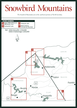
The Snowbird Mountains section [Fig. 37] lies in the extreme southwestern portion of the state, shaped primarily by the Great Smoky Mountains and the Unicoi Mountains (the southernmost mountains in the Unaka range). The Snowbird Mountains are a less significant cross range, but they were chosen to identify this section because the name Snowbird is associated with this area of the state. Other ranges that define this rugged and isolated region include the Cheoah and Yellow Creek mountains. The states of Georgia and Tennessee and the Great Smoky Mountains National Park form most of this section's geographic boundaries.
 Some
of the state's most spectacular forests thrive here, in part because this area
is decidedly less developed than other parts of Western North Carolina. Certainly
the forests and wildlife benefit from less human intervention, but the other
side of the coin is less money to maintain the resources and foster their appreciation.
Some
of the state's most spectacular forests thrive here, in part because this area
is decidedly less developed than other parts of Western North Carolina. Certainly
the forests and wildlife benefit from less human intervention, but the other
side of the coin is less money to maintain the resources and foster their appreciation.
This section, for example, does not include the Blue Ridge Parkway; however, the Snowbird Mountains section recently saw the opening of a new road that is already bringing new opportunities. Opened in October 1996, the 17.5-mile Cherohala Skyway runs from Santeetlah Gap in North Carolina to Beech Gap at the Tennessee state line. The skyway ranges in elevation from 3,000 feet at Santeetlah Gap, to its highest point at Haw Knob at 5,472 feet, and down again to 4,490 feet at Beech Gap. The name Cherohala is a combination of the names of the national forests through which it runs—Cherokee in Tennessee and Nantahala in North Carolina.
The U.S. Forest Service has given the same attention to blending the road in with its environment as workers did earlier this century on the Blue Ridge Parkway. Guardrails are a natural rusted brown to blend with the earth and trees. Scenic overlooks are defined by attractive rock walls. Some overlooks, such as the one at Spirit Ridge, are handicapped accessible and offer expansive views of the magnificent landscape of Joyce KilmerSlickrock Wilderness and Snowbird Creek basin. Other overlooks connect with hiking trails such as the one to Hooper Bald, elevation 5,429 feet, near where the wild Russian boar was first introduced to North Carolina. Interpretive stations, restrooms, and picnic areas are also planned.
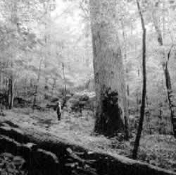
 The
Joyce KilmerSlickrock Wilderness [Fig.
37(38), Fig. 38] is perhaps the best-known
destination in the Snowbird Mountains section. The magnificent virgin and old-
growth forests, mercifully preserved in spite of the overlogging experienced
throughout Western North Carolina, harbor ancient trees that grow to a height
of more than 150 feet and a girth of 20 feet. A number of man-made lakes—Fontana,
Cheoah, Calderwood, and Santeetlah—are also popular sites for camping,
fishing, and hiking.
The
Joyce KilmerSlickrock Wilderness [Fig.
37(38), Fig. 38] is perhaps the best-known
destination in the Snowbird Mountains section. The magnificent virgin and old-
growth forests, mercifully preserved in spite of the overlogging experienced
throughout Western North Carolina, harbor ancient trees that grow to a height
of more than 150 feet and a girth of 20 feet. A number of man-made lakes—Fontana,
Cheoah, Calderwood, and Santeetlah—are also popular sites for camping,
fishing, and hiking.
Rangers within the national forests are continually working to maintain and improve these natural treasures. At the Beech Creek Seed Orchard, located west of Murphy off FR 307, improved tree seeds for reforestation are developed and later supplied to the southern Appalachian forests. These genetically improved seeds of white, shortleaf, and Virginia pines provide foresters with an opportunity to grow more and better wood throughout the national forests. The orchard has extensive hardwood clone banks of black cherry, oak, and yellow-poplar.
In 1994, the North Carolina Department of Transportation designated a scenic byway through the area known as Indian Lakes Scenic Byway, taking its name from the lakes along its route. The picturesque, though sometimes sharply curving, route courses through the Stecoah Valley along NC 28 west from Almond to Fontana Lake and past the Cheoah Lake and Dam. The destination-rich route then continues on US 129 south to the Santeetlah Dam and Lake, through the town of Robbinsville, and past Tallulah (Cherokee for "cry of the frog") Creek, which joins Sweetwater Creek to form the Cheoah River. At US 19/74 the route ends just south of the Nantahala Gorge.
 For
more information on hiking, picnicking, boating, fitness/jogging trails, and
historical and forest-management interpretive trails within this section as
well as the wilderness, backcountry, and lakes, contact the Cheoah Ranger Station,
phone (704) 479-6431. The office is located adjacent to Lake Santeetlah on SR
1116, 2 miles north of Robbinsville off US 129. Office hours are 8:00 to 4:30,
Monday through Friday, year-round. Extended summer-season days and hours are
possible. A Civilian Conservation Corps campsite, Camp Santeetlah, which previously
occupied the site, is interpreted by a 2.5-mile trail to a scenic overlook of
the mountains.
For
more information on hiking, picnicking, boating, fitness/jogging trails, and
historical and forest-management interpretive trails within this section as
well as the wilderness, backcountry, and lakes, contact the Cheoah Ranger Station,
phone (704) 479-6431. The office is located adjacent to Lake Santeetlah on SR
1116, 2 miles north of Robbinsville off US 129. Office hours are 8:00 to 4:30,
Monday through Friday, year-round. Extended summer-season days and hours are
possible. A Civilian Conservation Corps campsite, Camp Santeetlah, which previously
occupied the site, is interpreted by a 2.5-mile trail to a scenic overlook of
the mountains.