 Southern
Nantahala Wilderness Area/Standing Indian Area Southern
Nantahala Wilderness Area/Standing Indian Area
Southern
Nantahala Wilderness Area/Standing Indian Area Southern
Nantahala Wilderness Area/Standing Indian Area [Fig. 36] The Southern Nantahala Wilderness was created by the 1984 Wilderness Acts in both North Carolina and Georgia and is managed as part of the Nantahala National Forest in North Carolina and the Chattahoochee National Forest in Georgia. It includes 23,714 acres at the southern end of the Blue Ridge Mountains. Elevations range from 2,400 feet to 5,499 feet on Standing Indian Mountain. The area includes numerous peaks taller than 4,000 feet and is characterized by steep, rugged terrain dissected by several streams and drainages that feed the Nantahala, Tallulah, and Hiwassee rivers. Typically, the forest cover is dense and varies from spruce-fir and grass-heath balds at the higher elevations to mixed hardwoods at middle elevations.
Standing Indian Mountain, the highest point in the Southern Nantahala Wilderness, stands as a sentinel, watching over the diverse range of habitats and wildlife on its descending slopes and in the wetlands and river basin below. According to Cherokee myth, the 5,499-foot peak is the stone remains of an actual watchman, an Indian warrior sent to the mountaintop to keep a lookout for the winged monster that had stolen a village child. When the Great Spirit answered the village's prayers and destroyed the monster with a furious lightning storm, the mountain was shattered and the lone scout was turned to stone. The legend also "explains" the treeless heath or shrub bald summit, covered primarily with purple rhododendron.
 Farther
below, the ridge supports pine and hemlock groves, mountain laurel, and red
and white oak forests with fern, azalea, and blueberry understory. Some drier,
almost bare soil areas down the 1.5-mile ridgeline are covered with a rare tundra
species, the three-leaved cinquefoil (Potentilla tridentata). This threatened
plant exists here at the southern periphery of its range.
Farther
below, the ridge supports pine and hemlock groves, mountain laurel, and red
and white oak forests with fern, azalea, and blueberry understory. Some drier,
almost bare soil areas down the 1.5-mile ridgeline are covered with a rare tundra
species, the three-leaved cinquefoil (Potentilla tridentata). This threatened
plant exists here at the southern periphery of its range.
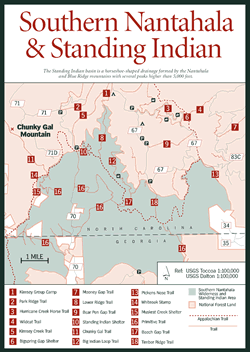
The Standing Indian basin is a horseshoe-shaped drainage formed by the Nantahala and Blue Ridge mountains, which include several peaks higher than 5,000 feet. Numerous trails wind through the basin along old roadbeds, including 17.7 miles of orange-blazed trails designated as horse trails: Big Indian Loop Trail [Fig. 36(12)] (8 miles, moderate to difficult), Blackwell Gap Trail (4.2 miles, moderate) and Hurricane Creek Loop Trail (5.5. miles, moderate). The abundance of trails, higher elevations and the resulting cooler temperatures, and beautiful scenery through the forest and along streambeds makes this a popular destination for horseback riders from across the Southeast. Primitive camping featuring 20 sites and 40 hitching posts for horses is available at Hurricane Creek beyond the developed Standing Indian Campground.
A network of loop trails throughout the area connects with the strenuous, 5-mile (round-trip) hike to the top of Standing Indian. (Standing Indian Area trail maps are available through the Forest Service.) In addition, the Appalachian Trail, at its highest point south of the Smoky Mountains, skirts the southern and eastern ridge of the basin, serving as a master connector route. The purple rhododendron and flame azalea make this section of the Appalachian Trail especially stunning in late spring and early summer. Off the trail, deep in the ridge forest, pits remain as relics of a time when mica was mined in the area.
The Nantahala River, which flows through the Standing Indian Basin (and through the Standing Indian Campground), provides excellent trout-fishing opportunities. Along the river's upper route, varieties of salamanders, frogs, turtles, and rare plants thrive in the area's bogs, swamps, and marshes. The hardwood forests create habitats for a range of wildlife including bear, wild boar, white-tailed deer, ruffed grouse, owls, and hawks.
Forests in this area are virtually all second growth. In the 1920s, the Ritter Lumber Company began operating one of its main logging camps out of the basin and removed most of the virgin timber by the early 1930s. Today, 11,944 acres are protected in North Carolina as the Southern Nantahala Wilderness Area (additional acreage lies in Georgia). The beautifully landscaped Standing Indian Campground is on the site of the former logging camp.
Nearby, the second-largest poplar in the United States survives. The John Waslik Memorial Poplar, named after a former Wayah District ranger, was too large for the company's oxen to haul out, so it was left standing. The giant tree is 25 feet in circumference and, until a storm blew its top off, was 125 feet tall.