
The historic significance of Oak Ridge is monumental: in 1943 scientists involved in the top-secret "Manhattan Project" at this obscure rural location created the technology that led to the production of the first atomic bomb. It was a discovery that eventually affected every human being on the planet in one way or another.
Yet until the bombs were dropped on Japan in 1945, Oak Ridge didn't exist. It was a city behind a fence that was not on any map. Throughout the war it remained a maximum-security operation.
Today, Oak Ridge is a vibrant city and the home of the Department of Energy's Oak Ridge National Laboratory, a multipurpose, multiuse facility for basic science research and development in energy resources, environmental quality, educational foundations, and economic competitiveness, and the American Museum of Science and Energy, a center for exploration of science, technology, and Oak Ridge history. Oak Ridge is also the headquarters for the Tennessee Citizens for Wilderness Planning (TCWP), the organization that spearheaded the crusade that led to the establishment of the Big South Fork National River and Recreation Area. Subsequently the TCWP has contributed to efforts that led to the abandonment of a plan to build another highway across the Great Smoky Mountains National Park; to the passage of the Tennessee Scenic Rivers Act; to the inclusion of the Obed River in the National Wild and Scenic Rivers system; and to the passage of the Tennessee Natural Areas Preservation Act and the Tennessee Trails System Act.
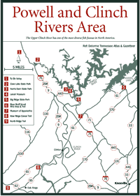
[Fig. 23(9)] This trail, built and maintained by the TCWP, is a National
Recreation Trail and one of the first inside a city. It is located on public
greenbelt lands on the city's northern border. There are eight access points.
The westernmost access is about 1.4 miles west of Illinois Avenue (TN 62) on
West Outer Drive. The easternmost access is on the extension of Endicott Lane
that runs north off East Outer Drive. The entire trail is north of the West
Outer Drive and the East Outer Drive.

The trail features hardwood forest, streams, and rock formations.
[Fig. 23(8)] This is a 4-mile loop in a flatwater area in Melton Hill Reservoir that follows the shoreline and coves, offering a view of a variety of shorebirds, duck, geese, ospreys (Pandion haliaetus), kingfishers (Megaceryle alcyon), and muskrats (Ondatra zibethicus).