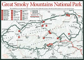
There are more than 150 hiking trails in the park, with origins that represent an almost encyclopedic history of the area, dating back to long before the appearance of the first white man. Some of the earliest were game trails created by migrating bison, elk, and other large animals. Many became Indian traces used for trading between tribes and for warpaths.
When settlers moved into the Smokies, some of these became sled and wagon roads. Later, when the big lumber companies came to harvest the timber, a vast number of logging roads and railroads were built that traveled far back into the mountains.
Many hiking trails follow all or parts of these routes, but there are many others that were developed by the CCC, Park Service, and hiking clubs to reach scenic places, historic locations, or other interesting features.
The most famous is the 72.1-mile section of the Appalachian Trail (see Appalachian Trail, page 297), which follows the crest of the mountains from the Pigeon River to the Little Tennessee River.
The system of trails in the park is complex and extremely varied in regard to length, degree of difficulty, and condition. They range from short, level, well-maintained paths that are accessible to the handicapped, to rugged, nearly vertical trails that should be attempted only by well-conditioned hikers.
Some of the most popular trails are the day loops that require only a light pack, and these can be found at locations throughout the park. There are also plenty of overnight hikes that utilize the backcountry campsites.
The self-guided nature trails are popular because there is easy access to these short, casual walks.
Ranging from 0.5 to 1 mile round-trip, the nature trails are loops featuring natural history, beauty, and accessibility. These are generally easy trails with minimal changes in elevation that are suitable for all ages. Brochures available at the trailheads or at one of the visitor centers describe highlights.
[Fig. 45(4)] This 1-mile, round-trip trail is a good spot for spring wildflowers including bleeding heart (Dicentra eximia), showy orchis (Orchis spectabilis), and the nodding Vasey's trillium (Trillium vaseyi) in April and May. The trail follows a portion of Cosby Creek across numerous footbridges and past old house sites.
The arching, glossy green leaves of dog-hobble grow so thick in many areas of the Smokies, including along the Cosby Nature Trail, that bears could escape the hunting dogs of early settlers by crashing through the dense growth that hobbled or tangled the pursuing dogs.
[Fig. 45(5)] This 0.75-mile round trip is known for its abundance of white trillium and solomon's seal (Smilacina racemosa) and its route by an old log home, barn, and water-powered tub mill. This is one of the best wildflower walks in the Smokies.
[Fig. 47(1)] Many wildflowers flourish along this 1-mile, round-trip trail including touch-me-nots (Impatiens pallida), doll's-eyes (Actaea pachypoda), little brown jug (Asarum arifolium) of the Birthwort family, and foamflower (Tiarella cordifolia). Native shrubs in the area include hearts-a-bustin' (Euonymus americanus) and sweetshrub, or Carolina allspice (Calycanthus floridus).
The trail follows a tumbling creek through rhododendron thickets and second-growth forest and past the restored log cabin of John Ownby.
[Fig. 47] This 0.8-mile, round-trip trail travels through an area logged by the Little River Lumber Company nearly 70 years ago. On the drier southern slopes, a pine-oak forest prevails, while a cove hardwood forest and wildflowers blanket the northern slopes. The brochure directs you in reading the landscape to discover portions of Elkmont's past visible in the forest terrain.
[Fig. 44] A dry pine-oak forest with a dogwood understory is visited on this 0.75-mile, round-trip hike. You may spot pink lady's slipper (Cypripedium acaule) on this trail in April or May. The trail introduces visitors to native plants and their uses by early settlers in the cove.
This popular, 0.75-mile, round-trip trail traverses some second-growth forest as well as mature cove hardwoods. Wildflowers are abundant on the moist slopes beneath Eastern hemlock, buckeye, basswood, yellow poplar, white ash (Fraxinus americana), black locust (Robinia pseudo-acacia), flowering silverbell (Halesia carolina), and sugar maple. Yellow trillium (Trillium luteum), trout lily (Erythronium americanum), Dutchman's breeches (Dicentra cucullaria), false solomon's seal (Maianthemum racemosum), white trillium (Trillium grandiflorum), tiny fringed phacelia (Phacelia fimbriata), and sharp-lobed hepatica (Hepatica nobilis) may be spotted along the trail.
[Fig. 47] The yellow variety of Clinton's lily, or ead lily (Clintonia borealis), and wood sorrel (Oxalis montana) are found along the 0.5-mile, round-trip hike through old-growth red spruce and Fraser fir trees, which are under attack from the balsam woolly adelgid.
[Fig. 44(14)] Watch for yellow trillium and great chickweed (Stellaria pubera var. silvatica) along this 0.75-mile round trip that crosses Bradley Fork Creek. Although not indigenous, Norway spruces (Picea abies) found their way here from burned areas that were reforested before the area was part of the park. The effects of logging and farming are examined.
[Fig. 48] This 0.75-mile, one-way trail takes you through hardwood forests of beech, birch, and maple followed by spruce-fir forest. You're likely to spot spring beauties (Claytonia caroliniana) and trout lilies along the trail in April and May. The northern hardwood forest growing at more than 1 mile above sea level is explored in a brochure available at the trailhead or one of the visitor centers.
The following hiking trips range from four to eight hours hiking time and range from moderate to strenuous.
[Fig. 44(8)] This is one of the most popular walks in the GSMNP, initially passing through an old-growth forest of yellow buckeye (Aesculus octandra), beech, Eastern hemlock, and an understory of rhododendron. The trail then climbs stone steps through Arch Rock, a natural tunnel created by erosion, and onto a large heath bald covered with sand myrtle (Leiiophyllum lyoni), mountain laurel, and purple rhododendron before reaching Alum Cave Bluffs, a 100-foot-high cliff of black slate about 2.2 miles from the trailhead. Another 2.5 miles brings you to the top of Mount Le Conte near Le Conte Lodge.
[Fig. 44(4)] Because of the steepness of this trail, it isn't recommended for hikers who are not in good physical condition. The first portion of the trail passes over the Walker Camp Prong of the Little Pigeon River and passes a large Fraser magnolia (Magnolia fraseri) with eight trunks. If you pass this way in April or May you may see its large creamy white blooms.
Beyond is another creek crossing, Road Prong, with stands of yellow buckeye (Aesculus flava), the only tree in the park with five leaflets joined in the center to form a compound leaf. Early settlers thought the dark, shiny brown nut of the tree looked like the eye of a deer. There are some large specimens along the trail. You will also find a profusion of wildflowers in the spring. After this placid streamside walk, from the beginning of the ascension to the pinnacles, the going is rocky and rugged.
[Fig. 44(18)] The Lower Mount Cammerer Trail to the Mount Cammerer Fire Tower begins in the Cosby Campground and generally keeps to the lower sides of ridges as it weaves in and out of creek valleys. It begins as a gravel road passing old house sites in the former settlement area, but soon it begins to climb the western edge of Sutton Ridge.
The areas along the western ridges are drier with open oak forests. Hollows support wildflower colonies of spring beauties, hepatica, Indian cucumber (Medeola virginiana), and trillium, including the maroon wake robin trillium (Trillium erectum). Rhododendron and mountain laurel are abundant. The trail continues to weave along the dry western edges, rounding the points and cutting back to the moist eastern coves created by several creeks as it winds its way along the side of Mount Cammerer.
After traveling through forests of hemlocks and maple with an understory of flowering dogwoods, the trail intersects the Appalachian Trail (AT) 7.4 miles from the campground. Travel 2.3 miles along the AT through mountain laurel, rhododendron, hemlock, and spruce before reaching the craggy pinnacle and the Mount Cammerer Fire Tower, a 1930s project of the Civilian Conservation Corps.
The octagonal fire tower and its wooden catwalk were restored in 1995. The outstanding 360-degree views from this vantage point on the eastern end of the park extend to the Unaka Mountains to the east, Mount Sterling with its fire tower 5 miles to the south, and the Pigeon River valley and Douglas Lake to the north.
[Fig. 44, Fig. 45, Fig. 46, Fig. 47] The Appalachian Trail is a 2,100-mile hiking trail stretching along the crest of the Appalachian Mountains from Springer Mountain in Georgia to Mount Katahdin in Maine. The 70 miles of the trail within the GSMNP are primarily located along the highest part of the main ridge that runs through the Smokies from southwest to northeast.