| |
The Natural Georgia Series: The Flint River |
 The
Natural History of the Flint River
The
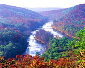
Natural History of the Flint RiverFrom its humble beginning at the base of the world's busiest airport, the Flint River quickly transforms into one of the most beautiful wild and scenic riverine environments in Georgia. According to the Scenic Rivers Report of 1970, "The upper portion of the Flint is undoubtedly the most picturesque stream in the Georgia Piedmont." The watershed of the Flint encompasses 8,460 square miles of Georgia's Piedmont and Coastal Plain physiographic provinces. Within its watershed the Flint can be clearly subdivided into three unique riverine regimes based on landscape, channel characteristics, flora, and fauna. The upper part of the Flint flows through the red hills of Georgia's Piedmont physiographic province where it has etched deeply into the crystalline rocks that underlie this region. As the river crosses the fall line near Culloden, its channel geometry changes from deeply incised to a broad, forested swampy floodplain. This middle section of the Flint extends from the fall line to Lake Blackshear near Cordele. South of Lake Blackshear the river landscape again changes. In this, the lower section, the Flint has eroded well into the limestone rocks that form the Upper Floridan aquifer in southwest Georgia.
Because of the meandering nature of the river channel throughout much of its course, a boater would cover nearly 350 miles within a basin that measures only 212 miles in length. The Flint flows unimpeded for nearly 220 river miles, which makes it rather unique. There are only 40 rivers in the U.S. that flow more than 200 river miles unimpeded. If developers had completed their plans, the Flint today would not be a part of this elite group. In the early 1970s, then Georgia Governor Jimmy Carter had the vision and courage to protect the natural integrity of the river that he had grown to love. After a cost-benefit analysis, Carter personally blocked the U.S. Army Corps of Engineers' efforts to construct a reservoir by damming the Flint at Sprewell Bluff near Thomaston. Thanks to his efforts, the Flint continues to flow freely through one of the most naturally beautiful and ecologically diverse sections of Georgia.
The importance of the Flint River certainly is not limited to its treasures of natural beauty and environmental diversity. More than 600,000 Georgians make the Flint River Basin their home. Folks from south Atlanta to Thomaston rely on the river and its tributaries for their water supply. In the Coastal Plain, the aquifers that are intricately tied to the area's streams are relied upon almost exclusively for municipal, domestic, industrial, and agricultural water supplies. Water use in this region is dominated by the huge agricultural industry of southwestern Georgia with more than 1,145,000 acres in crop production. Water needed to quench the thirst of this industry is primarily pumped from the Upper Floridan aquifer, as well as streams and ponds.
Potential effects of heavy agricultural pumping are not fully understood and there is concern that the water resources may be stretched to their limits during times of prolonged drought. There is also concern that the growing need for additional water supply in the metropolitan Atlanta area may impact the in-stream flows of the Flint. The development of additional upstream reservoirs located on Flint River tributary streams seems inevitable. Environmentalists wonder about the effects of additional impoundments and withdrawals on in-stream flows and aquatic habitat. These are only some of the issues threatening the natural diversity and beauty of the Flint River.
 In
the humid southeastern U.S., practically all streams originate as groundwater
seeps or springs and the Flint is no exception. The river begins its tortuous
course through Georgia in the heart of the Piedmont physiographic province as
a groundwater seep emanating from fractured, crystalline rocks that underlie
the runway system at Hartsfield International Airport, located just a little
south of downtown Atlanta. The groundwater flow is augmented by stormwater runoff
from the high density of impervious surfaces common to this part of the state.
Impervious surfaces can be roads, runways, parking lots, and buildings-essentially
any surface than is not porous and prevents rainfall from infiltrating into
the soil. During times when it is not raining, the flow of the river in the
headwater area is sustained by the small amount of groundwater seepage. But,
when it rains the river level can swell very quickly, and the river can become
a raging torrent in a very short period of time; however, once the rains end,
the river level recedes as quickly as it rose. Thus, in this part of the river
regime, the Flint is not much more than a drainage canal carrying the storm-water
runoff and myriad impurities that wash off from the impervious surfaces.
In
the humid southeastern U.S., practically all streams originate as groundwater
seeps or springs and the Flint is no exception. The river begins its tortuous
course through Georgia in the heart of the Piedmont physiographic province as
a groundwater seep emanating from fractured, crystalline rocks that underlie
the runway system at Hartsfield International Airport, located just a little
south of downtown Atlanta. The groundwater flow is augmented by stormwater runoff
from the high density of impervious surfaces common to this part of the state.
Impervious surfaces can be roads, runways, parking lots, and buildings-essentially
any surface than is not porous and prevents rainfall from infiltrating into
the soil. During times when it is not raining, the flow of the river in the
headwater area is sustained by the small amount of groundwater seepage. But,
when it rains the river level can swell very quickly, and the river can become
a raging torrent in a very short period of time; however, once the rains end,
the river level recedes as quickly as it rose. Thus, in this part of the river
regime, the Flint is not much more than a drainage canal carrying the storm-water
runoff and myriad impurities that wash off from the impervious surfaces.
Throughout the Piedmont, flow of the Flint is sustained primarily by precipitation; however, the streamflow is augmented by variable rates and volumes of groundwater inflow. Groundwater seeps into the Flint and its tributary streams from the weathered regolith, called saprolite, that overlies the dense crystalline rocks of this region. In some areas the crystalline rocks have been fractured by movement of the earth's crust, and groundwater can flow from these fractures where the streams have eroded through the soil and regolith layers. But, in most areas of the Piedmont, the relatively low permeability of the saprolite and crystalline rocks limits the rate and volume of groundwater inflow.
In the Jonesboro area, about 15 miles south of the headwaters of the Flint, the character of the stream channel changes dramatically from a well-confined, steep-sided drainage canal, to a swampy, broad, riparian floodplain. Floodplains like these along the Flint are called riparian wetlands and are ecosystems in which the soils and soil moisture are strongly influenced by the river. These transitional bottomland hardwood forests, found extensively throughout the southeastern U.S., separate the river from the upland. In the Jonesboro area, these low-lying, flat, extensive floodplains fill with water during periods when the river spills over its banks from rapid stormwater runoff, and the forests prevent the torrent of water from rushing downstream. Wetlands are extremely important to our environment because they filter contaminants and sediment from the stormwater and slowly release the naturally cleaned water back into the Flint. Because they release the water slowly, these wetlands help the Flint to continue flowing during times when it does not rain. Keeping these riparian wetlands intact is an important part of maintaining natural flood control and water quality in the Flint River Basin.
At the U.S. Geological Survey stream gaging station located near Lovejoy, about 40 miles south of the headwaters area, flows in the Flint are much less dynamic than in the upstream areas, and the quality of the water is greatly improved because of the riparian ecosystems. In addition to their function as natural filters, the riparian ecosystems provide refuge for many animals, a broad diversity of habitat, and abundant water. In areas where development has encroached near the border of the wetland, the riparian zone provides a migration corridor for many animals.
The Flint continues its southerly flow across the Georgia Piedmont and progressively gains in size as many tributary streams merge with the river. The clayey soils and relief of the landscape in the Piedmont encourage rainfall runoff rather than deep infiltration. As a result, a dendritic drainage network has developed with many large streams that are tributaries to the Flint River. During the winter months, when the Flint River Basin receives much of its 50 to 52 inches of annual rainfall, the streams typically spill over their banks into the floodplains and restore the riparian ecosystem. On average, the streams of the Piedmont flood more than once each year. During periods of heavy rainfall flooding can be severe. A record flood occurred in July 1994 as a result of heavy rains produced by Tropical Storm Alberto. In the upper Flint Basin this flood exceeded the 100-year recurrence interval, which means there is only a 1 percent probability that this section of the river will experience a flow of this magnitude in any given year.
 In
the southernmost part of the Piedmont province the resistive rocks and topographic
relief of the Pine Mountain area have contributed to the development of a unique
middle Georgia riverine environment through Sprewell Bluff, which is located
a few miles west of Thomaston. The Sprewell Bluff area includes a 4-mile-long
section of the Flint River and several of its tributaries. Approximately 30
to 50 million years ago, geologic faulting uplifted Precambrian-age crystalline
rocks, leaving 550-million-year-old crystalline rocks of the Hollis Quartzite
formation in direct contact with Coastal Plain sediments. As a result of the
uplift, Pine Mountain was formed, which significantly impeded the flow of the
river system we now call the Flint. Eventually the strong erosive forces of
the river cut through the less resistant part of the elevated landscape. The
remaining resistive quartzite rocks form the present-day river shoals, which
provide habitat for many aquatic animals including the unique Flint River shoal
bass, also known as the redeye bass. The erosive forces of the river are still
at work, continuing the down-cutting process that was begun millions of years
ago.
In
the southernmost part of the Piedmont province the resistive rocks and topographic
relief of the Pine Mountain area have contributed to the development of a unique
middle Georgia riverine environment through Sprewell Bluff, which is located
a few miles west of Thomaston. The Sprewell Bluff area includes a 4-mile-long
section of the Flint River and several of its tributaries. Approximately 30
to 50 million years ago, geologic faulting uplifted Precambrian-age crystalline
rocks, leaving 550-million-year-old crystalline rocks of the Hollis Quartzite
formation in direct contact with Coastal Plain sediments. As a result of the
uplift, Pine Mountain was formed, which significantly impeded the flow of the
river system we now call the Flint. Eventually the strong erosive forces of
the river cut through the less resistant part of the elevated landscape. The
remaining resistive quartzite rocks form the present-day river shoals, which
provide habitat for many aquatic animals including the unique Flint River shoal
bass, also known as the redeye bass. The erosive forces of the river are still
at work, continuing the down-cutting process that was begun millions of years
ago.
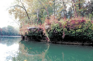
At present, Sprewell Bluff, located on the eastern end of Pine Mountain, stands several hundred feet above the course of the Flint River. Piney Woods Ridge, which is on the east bank, ranges in elevation from 500 to 900 feet above sea level. The rock bluffs on the western side range from 700 to 1,000 feet above sea level.
Sprewell Bluff is truly a botanical melting pot where one can find a mixture of mountain and Coastal Plain flora and fauna. Blue-stem palmetto can be found growing within a stone's throw of trees and shrubs that are normally found only in the higher elevations. Efforts are under way to protect this special piece of Georgia. The Georgia Department of Natural Resources has developed the Sprewell Bluff Wildlife Management Area in an effort to protect the area from development and to make it available for all Georgians to enjoy
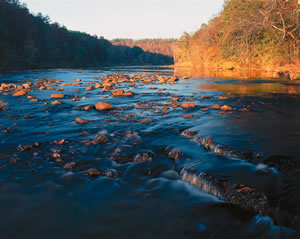
Continuing downstream from Sprewell Bluff, the shoal riverine environment is suddenly transformed into the raging, whitewater rapids of the fall line ravines. During higher stream stages, these rapids create a Class III and Class IV paddling opportunity that should be seized by only those proficient at the sport. Over a 2.5-mile stretch of river, beginning at Georgia Highway 36, the Flint plunges more than 70 feet in elevation.
Of particular challenge to paddlers is a 1-mile stretch of river known as Yellow Jacket Shoals where the river drops nearly 40 feet. If you are lucky, skilled, or both, and survive the wild ride you will see one of the most interesting and picturesque sections of the Flint. The quartzite shoals of the Sprewell Bluff area are replaced with flat-lying granitic rocks that stretch across the river. It's hard to imagine that these rocks were used as a natural bridge by Native American travelers as recently as a few hundred years ago. Within this relatively small ecological setting, the biological diversity is truly mind-boggling and even exceeds that found upstream at Sprewell Bluff. Here hardwood slopes transcend into river riparian zones studded with 550-million-year-old rocks. Spanish moss hangs from swamp gum and shagbark hickory. In many places the rocks are grouped in the river to form small islands. During the summer months, the rare and endangered shoals spider lily (Hymenocallis coronaria) and blue flag (Iris virginica) can be found blooming on the rock islands.
The sharp geologic transition from the Piedmont to the Coastal Plain is accompanied by an immediate change in physiography and a very impressive change in scenery. Quartzite and granitic rock outcrops observed on the hill slopes and as river shoals in the southern Piedmont are replaced in this river section by deeply incised sandy banks and broad, forested, riparian floodplains. The river is deep, wide, and slow, thus allowing the sediments transported from the Piedmont to fall to the stream bottom. When the upstream rainfall is heavy, the Flint overflows its banks and transports fine-grained sediment into the riparian woodlands. Over time, a vast alluvial floodplain has formed.
 As
is typical with most Georgia streams that flow from the Piedmont, the periodic
flooding of the Flint has formed an extensive fall line swamp just south of
the area where the river flows onto the Coastal Plain. This swamp extends from
just south of the fall line all the way to the city of Montezuma. This floodplain
swamp is commonly referred to as the Great Swamp, but actually consists of two
swamps. The swampy area north of GA 96 is known as Magnolia Swamp and the swamp
south of the highway is called Beechwood Swamp. Together they form the largest
riparian swamp on the main stem of the Flint. During periods of high water,
the Great Swamp encompasses an area of many thousands of acres, but when river
levels are low, the Great Swamp drains and the remaining interior wetlands are
isolated and sparse.
As
is typical with most Georgia streams that flow from the Piedmont, the periodic
flooding of the Flint has formed an extensive fall line swamp just south of
the area where the river flows onto the Coastal Plain. This swamp extends from
just south of the fall line all the way to the city of Montezuma. This floodplain
swamp is commonly referred to as the Great Swamp, but actually consists of two
swamps. The swampy area north of GA 96 is known as Magnolia Swamp and the swamp
south of the highway is called Beechwood Swamp. Together they form the largest
riparian swamp on the main stem of the Flint. During periods of high water,
the Great Swamp encompasses an area of many thousands of acres, but when river
levels are low, the Great Swamp drains and the remaining interior wetlands are
isolated and sparse.
During normal years, when annual precipitation in the basin typically exceeds 50 to 52 inches, the Flint floods an average of 1.5 times. Floods are important to the riparian ecosystem because they sustain a healthy, functioning wetland that provides a great service to the Flint River. When the muddy Flint spills over its banks into the riparian wetlands, changes in water quality quickly become apparent in the backwaters of the Great Swamp. Not only is turbidity reduced as particles fall out, but also the color of the water deepens due to the leaching of tannins and other organic compounds from the abundant litter fall. This dissolved organic matter provides the needed fuel for beneficial microorganisms to carry out natural biofiltration of the water and remove harmful constituents that might otherwise persist. The waters of the Flint River and all those who enjoy the river receive untold benefits from the Great Swamp.
The soft, sandy sediment that forms the stream channel in the upper Coastal Plain is easily eroded by the persistent and often turbulent flow of the river. As a result, the stream channel is continually migrating. Each time the waters rise, the stream bank on the outside of curves is undercut and the overlying sediment and plants collapse into the river. The added sediment is transported to the next river bend where some of it is deposited on the inside of the bend where the flow of the water slows. Eventually, the sediment accumulates to form a point bar. Point bars make great places to camp, or to just take a break to enjoy the river from a different perspective. Night time fishing for flat-head and channel catfish can be terrific in the deep holes located off the downstream end of many point bars. But, be careful when selecting your campsite. You don't want your tent to interfere with an alligator's pathway from the interior wetlands to the river. The interior wetlands and river ecosystem are home to numerous animals that can be viewed by a quiet boater. Whitetail deer, hogs, beaver, turkey, otter, and squirrels are frequent visitors to the river.
As the river continues to wear away the stream bank on the outside of bends, and build point bars on the inside of bends, a horseshoe bend develops. Eventually, the Flint will cut through the remaining outside stream bank forming an oxbow, which is completely cut off from the new course of the river, except during times of flooding. It is much easier to spot oxbows from the air than from a boat. Fishermen who have discovered the secret passageways back into the oxbow lakes hold them as closely guarded secrets.
Navigation hazards in the middle section of the Flint are not rapids and rocky shoals like in the lower Piedmont. The boating impediments in this river section are large tree snags that have been transported and deposited during floods. The imbedded snags reach up from the river bottom to just below the water surface. When the river level is low the snags can create an obstacle course for boaters, but when the level is up they are not a problem. Although at times an annoyance to boaters, woody debris in rivers has tremendous ecological importance. Like shoals, wood deposits alter the local flow regime and provide unique habitat and foraging opportunities for numerous animals. Turtles and water snakes favor limbs and stumps as basking sites because they provide an easy escape route when unwanted company intrudes. The snags also provide important sanctuary and foraging areas for the many species of fish that make the Flint River their home. In particular, blue gill and bass can usually be found near the snags and log jams prevalent in this section of the river.
A few miles north of Montezuma, geologic and erosion processes have formed an escarped area in the Fort Valley Plateau district referred to as the Montezuma Bluffs. The state owns an area of about 500 acres that is the center of this unique landscape. Differential weathering has left a 150-foot-high escarpment overlooking a part of the Beechwood Swamp and the Flint River. Visitors can see fossilized limestone of the Tallahatta Formation that was part of an ancient marine ecosystem about 50 million years ago. The steep slopes leading up the escarpment are relatively undisturbed and are vegetated with old-growth beech and magnolia, as well as rare plant species. The natural area's steep, moist slopes contain one of the state's largest populations of the rare and endangered relic trillium. This natural area remains relatively undisturbed largely because the only access is by boat; no roads lead to Montezuma Bluffs.
 The
Flint continues on its course through the Coastal Plain and again makes a dramatic
transition as it flows through its southernmost physiographic district, the
Dougherty Plain. The river meanders less and becomes very narrow and well defined.
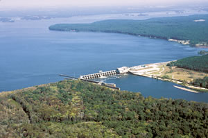
Near the city of Warwick, the Flint River finally encounters the first of three
main-stem impoundments. The Crisp County Power Dam backs up the Flint River
forming Lake Blackshear. This long, relatively shallow reservoir covers about
8,500 acres and is used for boating, fishing, and generation of electrical power.
The
Flint continues on its course through the Coastal Plain and again makes a dramatic
transition as it flows through its southernmost physiographic district, the
Dougherty Plain. The river meanders less and becomes very narrow and well defined.
Near the city of Warwick, the Flint River finally encounters the first of three
main-stem impoundments. The Crisp County Power Dam backs up the Flint River
forming Lake Blackshear. This long, relatively shallow reservoir covers about
8,500 acres and is used for boating, fishing, and generation of electrical power.
Below Lake Blackshear, the river begins to channel through the shallow Ocala Limestone and the river bottom gradually makes a transition from soft sediment to hard rock. Millions of years of erosion have left steep limestone bluffs, which dramatically change the appearance of the river corridor. Ferns including the Southern shield fern (Thelypteris kunthii) and hybrid spleenwort (Asplenium heteroresiliens) as well as a variety of mosses and lichens, drape the rocky outcrops in various shades of green. Cypress trees line the river corridor forming a canopy along the shoreline, while bare, entangled root masses of huge sycamore trees use the porous limestone to anchor themselves. There are several access points along this stretch of river providing opportunities to fish or canoe.
Farther south toward the city of Albany, the Flint River is constrained by a second power-generating dam, which forms Lake Chehaw. Covering an area of about 1,800 acres, Lake Chehaw is smaller than Lake Blackshear. Muckalee and Kinchafoonee creeks, two of the lower Flint River's larger tributaries, merge with the Flint just above the Georgia Power Dam at Lake Chehaw. Albany is the largest community within the lower Flint River Basin. Albany and other towns along the lower Flint have seen the river rage out of control twice in the 1990s. Water levels in the lower Flint exceeded the equivalent of a 500-year flood in 1994, and a 100-year flood in 1998. The resulting catastrophic personal and economic losses remind us that the Flint River is a powerful force that can't always be constrained.
The lower Flint River benefits from the presence of a number of plantations that occupy large tracts of land along the river and its tributaries. Historically, land management practices on plantations have emphasized the conservation of wildlife habitat. As a result, most of the riparian corridors along the lower Flint River and its tributaries from Albany to Bainbridge are relatively undisturbed and remain in excellent condition. Among the largest riverfront plantations are Ichauway, Pineland, Nonami, Blue Springs, and Riverview. These plantations undoubtedly have a positive effect on maintaining water quality and biological diversity within and along the river.
Between Albany and Bainbridge, the lower Flint flows through the heart of the Dougherty Plain and cuts into the Ocala Limestone formation to reach the water table of the Upper Floridan aquifer.
There are numerous areas along the lower Flint where natural springs make these connections to the aquifer evident. As many as 20 large springs and countless small seeps discharge groundwater into the lower Flint. Also called blue holes, many of the natural springs from Albany to Bainbridge are frequented by locals who use them to cool off on hot summer days. During extremely dry periods, groundwater inputs can increase river flow between Albany and Newton by as much as 50 percent.
 Radium
Springs, located near Albany, historically is the largest spring in the Flint
River Basin. Its aesthetic beauty, crystal clear water, and mythical healing
properties have long attracted people to the spring. Discharge from Radium Springs
can exceed 70,000,000 gallons per day.
Radium
Springs, located near Albany, historically is the largest spring in the Flint
River Basin. Its aesthetic beauty, crystal clear water, and mythical healing
properties have long attracted people to the spring. Discharge from Radium Springs
can exceed 70,000,000 gallons per day.
The abundance of natural springs make the Flint River different from most other river systems in Georgia and undoubtedly contributes to the high diversity of plant and animal life that is characteristic of the region. Groundwater emerges from the Upper Floridan aquifer at a constant temperature of about 68 degrees Fahrenheit year round. In the summer, the larger springs in the river channel serve as thermal refuges for the Gulf strain striped bass (Morone saxatilis) that requires cooler waters to survive. Cave divers have explored and mapped some of the larger underwater cave systems, which can extend for thousands of feet and open up into huge caverns. Deeper into the recesses of the aquifer, unusual forms of life that are uniquely adapted to these environmental conditions have been reported. The Georgia blind cave salamander (Haideotriton wallacei) and albino crawfish (Cambarus cryptodytes) are just a few examples of the unique inhabitants of the aquifer ecosystem.
Remnant bedrock in the river channel forms the lower Flint River's characteristic
limestone shoals. Large slabs of limestone can also be seen piled up at the
river's edge. These piles are often remnants of dredging activity that occurred
during the late 1800s and early 1900s to keep a navigable channel open from
Albany to the Gulf of Mexico. During this era, barges operated to transport
cotton and turpentine from this region. Since maintenance dredging ceased, storms
have reintroduced limestone debris to the river channel, restoring shoal habitat
and making the lower section of the Flint River, once again, non-
navigable by larger boats.
Although many view shoals only as hazards to outboard propellers, shoals provide important habitat for many of the Flint River's unique species of animals and plants. One would think that taking up residence in the middle of a rocky river channel would be living dangerously, yet a variety of plants can be found growing on the exposed rocks.
The underwater habitat around shoals is also unique and hosts an impressive diversity of animals, many of which are dependent on this habitat. Scour points that form on the downstream side of rocks offer protected pockets in the streambed ideal for colonization by filter-feeding mussels. Back eddies offer a resting place and good foraging habitat in otherwise rapid currents. A number of rare and threatened fish such as the Halloween darter (Percina sp.), grayfin redhorse (Moxostoma sp.), and bluestrip shiner (Cyprinella allitaenia), thrive in and around shoals. Hellgrammites (Corydalus sp.), large insect larvae, live and hunt around submerged rocks. Shoal habitat also supports numerous crawfish species, which feed on nutritious organic matter that accumulates on these structures. Both hellgrammites and crawfish are major prey for the shoal bass, a rare species of bass uniquely adapted to shoals and a prized game fish of the Flint River. When the river is low and clear, shoal bass can be seen just below the shoals, waiting in ambush for unsuspecting prey.
By the time the Flint River reaches Bainbridge, shoals are submerged, the river channel is deep and wide, and the flow of the river has slowed to a crawl. Along the way, river flow has increased from a trickle at Hartsfield airport to an average daily discharge at Bainbridge that ranges from 3 to 11 billion gallons per day. Although average discharge from the Flint River Basin is about 25 percent less than that from the Chattahoochee, its flow is an essential component of reservoir storage for Lake Seminole-the terminal point of the Flint River. The Jim Woodruff Lock and Dam was constructed in the 1950s to harness the Chattahoochee and Flint rivers for hydroelectric power and to facilitate barge traffic between the Gulf of Mexico and Bainbridge. Outflow from Lake Seminole forms the Apalachicola River that flows southerly and discharges into Apalachicola Bay. A dependable flow of high-quality water from this river-lake system is essential because it carries nutrients to Apalachicola Bay and supports a very productive estuary and lucrative seafood industry.
Flow of the Flint River in the headwaters area near Atlanta is dominated by stormwater runoff that often carries chemicals and impurities into the river. The riparian streamside buffers that have been preserved downstream from Atlanta effectively filter and clean the often-contaminated waters of the Flint.
Downstream, the personal intervention of Governor Jimmy Carter in the early 1970s preserved the natural beauty of the river as well as the flora and fauna of the Sprewell Bluff area. The Flint continues to flow freely through one of the most naturally beautiful and ecologically diverse sections of Georgia.
The middle and lower sections of the Flint River Basin are relied upon heavily by the agricultural industry for irrigation water supply. During the summer months many billions of gallons of water are pumped from the streams and aquifers in this region to quench the thirst of Georgia's farm crops. Even though this part of the state has experienced a prolonged and severe drought since June 1998, the condition of the water resources and the many aquatic habitats of the Flint River have, for the most part, persevered.
As the Flint approaches its terminal point at Lake Seminole where it loses its identity, the river gives way to the lake. Yet, the importance of the river to the health and prosperity of this region is immeasurable. The Flint River is important not only to Georgians but also to those in Florida who depend on the flow from Georgia to ensure the sustainability of the marine ecosystem in Apalachicola Bay. Thus, the value of the Flint River is again realized as it peacefully blends into the waters of the northern Gulf of Mexico.
Until now humans have managed to live in relative harmony with the Flint, and it remains a resilient river ecosystem. The natural history of the river includes catastrophic floods that have submerged the floodplain and its inhabitants, and extreme droughts that have reduced the river to a fraction of its normal flow. Through it all, the impressive diversity and beauty of plant and animal life that are characteristic of the entire Flint River system have remained.
The greatest challenge to the river system may be just over the horizon. The unbridled population growth that is ongoing in the metropolitan Atlanta area cannot continue without the development of new water supplies. The Flint and its tributaries are, without doubt, in jeopardy. The question remains unanswered, can the Flint River Basin continue to supply more and more water to the myriad consumers and remain a sustainable resource? The value of the water resources of the Flint River Basin to Georgia, in terms of economics, human welfare, and the environment is incalculable. For this reason, the prudent development and diligent conservation of these water resources are important concerns for everyone.
Go back to previous page. Go to The Flint River contents page. Go to Sherpa Guides home.
[ Previous Topic | Next Topic ]