 Valley
and Ridge III
  Valley
and Ridge III
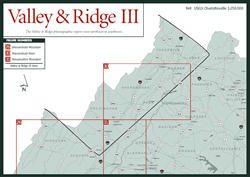
 This book divides the Valley and Ridge province into three sections: Valley and Ridge I, Valley and Ridge II, and Valley and Ridge III. The final section andnorthernmost section of the Valley and Ridge province, Valley and Ridge III, consists of two ranger districts of the George Washington National Forest, the sites of the famous Shendandoah Valley, and the Shenandoah River. Beginning with the Dry River district in the Shenandoah Mountains, this section extends roughly from Staunton to Winchester, bordered on the east by the mountains of the Blue Ridge and on the west by the West Virginia state line. The area includes the counties of Augusta, Rockingham, Page, Shenandoah, Warren, Frederick, and Clarke. The Shenandoah Valley entry overlaps the previous section, Valley and Ridge II, south to Natural Bridge. (For more information on the geology of the Valley and Ridge province, see the beginning of the Valley and Ridge section.)
Read and add comments about this page