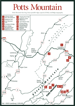
[Fig. 15] The New Castle Ranger District occupies 141,879 acres of the Jefferson National Forest northwest of Roanoke and Interstate 81. At the heart of the district in Craig County is the town of New Castle, where the ranger district office is located. The district spreads across the mountainous sections of Craig County and a big bite of southwestern Botetourt County, interspersed with private lands mostly in the river drainages. On the northwestern side, the New Castle District spills over Potts Mountain into Monroe County, West Virginia.
Long, linear parallel ridges, typical of Valley and Ridge topography, include Potts Mountain, Johns Creek Mountain, Sinking Creek Mountain, North Mountain, Bald Mountain, Richpatch Mountains, Price Mountain, and Patterson Mountain. The district is bordered to the west and southwest in southwestern Craig County by the Blacksburg Ranger District along VA 636, 658, 42, 209, 651, and 620. The southeast border runs from north central Roanoke County northeast into Botetourt County along a string of connecting roads that include VA 624, 311, 698, 690, 600, 666, 684, 682, and 681, and US 220 to Eagle Rock on the James River. To the northeast is the James River District of the George Washington National Forest, separated from the Jefferson by VA 615 and 621 and by the northwest borders of Botetourt County and Alleghany County.
The New Castle District is a good choice for recreation during peak seasons. When state parks and commercial sites are busting at the seams, the campgrounds, trails, and picnic areas in these western mountains may still offer solitude. The district has two campgrounds and three picnic areas, two wilderness areas, and several networks of hiking trails. Stop by the office on the north side of New Castle for a district map and advice on trails and facilities.
The New Castle Ranger District is crisscrossed at New Castle by three scenic roads. Running northeast/southwest are VA 42 and VA 615. VA 311 heads southeast and northwest out of New Castle.
VA 42. VA 42 comes into the district from the southwest through the basin of a high valley formed by the parallel ridges of Johns Creek and Sinking Creek mountains. Along the way are nineteenth-century homes, farms with rail fences, graveyards with tombstones of Civil War veterans, and places with the curious names of Looney and The Murder Hole. Private land reaches to the ridgetop on each side of the valley, where national forest lands begin. At the northeastern end of the valley, just southwest of New Castle, the two mountains curve toward each other, nearly meeting. From the air, the highland resembles a giant index finger pointing the way to the little town.
About 7.5 miles southwest of New Castle, VA 42 crosses the Continental Divide. Waters of Sinking Creek flow southwest into the New River and eventually make it to the Gulf of Mexico. Waters of Meadow Creek flow to the northeast, tumbling over Meadow Creek Falls at the tip of the index finger. Just south of New Castle, Meadow Creek pours fresh highland water into Craig Creek and sends it on its way to the James River and the Atlantic.
VA 615. [Fig. 23] VA 615, not a straight road by most standards, nevertheless takes a much shorter route down Craig Creek Valley than does the serpentine creek itself as both creek and highway connect New Castle in Craig County to Eagle Rock in Botetourt County.
Private land also borders this road on its course down Craig Creek Valley, but side roads lead to public national forest lands. The Ferrier Trail is on Lick Mountain 9 miles southeast of New Castle. Fenwick Mines Recreation Area is on Bald Mountain, 7 miles northeast of New Castle. Craig Creek Recreation Area and a network of Patterson Mountain trails are also accessible off VA 615, 11 miles northeast of New Castle near Oriskany. At the northeast end of Craig Creek Valley is a highlight of the district—the trail up Roaring Run. Six miles northeast of New Castle is VA 606, another designated scenic road that takes off from VA 615 to the southeast. On its way to Fincastle, 606 crosses Price Mountain, intersecting the long Price Mountain Trail at the top.
VA 311. [Fig. 22] Scenic VA 311 is a popular route into the New Castle district from I-81 or from Roanoke. From Exit 140 on I-81, it's a 10-mile trip north on 311 across Catawba Mountain to the southern boundary of the district and the southern end of North Mountain. The Appalachian Trail is accessible from a parking area here.
VA 311 then turns north to follow Craig Creek to New Castle. From New Castle to the West Virginia line, the road goes through the Johns Creek valley for a few miles then snakes its way across and between a succession of ridges to the base of Peters Mountain at the West Virginia line. Along the way are placid valleys and an outstanding mountaintop view on Potts Mountain. Steel Bridge Campground is on Potts Creek (VA 18) near the northwest end of this scenic road.
[Fig. 20(22)] This yellow-blazed trail follows craggy peaks and swales for 13 miles along the ridge of North Mountain, opening to many panoramic views. (This is a different trail from North Mountain Trail on Great North Mountain in Augusta County.) The ridgeline is on the Craig County/Roanoke County line at the southwestern end and on the Craig County/Botetourt County line on the northeastern end. Three spurs lead down the northwest slope from the North Mountain Trail to VA 224, branching off from the main trail at 2.4 miles (Deer Trail), 3.4 miles (Grouse Trail), and 6 miles (Turkey Trail) from the southwestern trailhead. A car waiting at the hikers' destination will keep them from having to backtrack.
The 9 miles on the southwestern end were once a part of the Appalachian Trail before the AT was rerouted. Across VA 311 from the southwestern trailhead, more trails lead to Dragon's Tooth, a fang-shaped mountain with rock outcroppings where views make the climb rewarding.
On the northeastern end, the trail connects to Price Mountain Trail, Ferrier Trail, and Lick Branch Trail. After crossing VA 606, Price Mountain Trail connects to Sulphur Ridge Trail for a 4.5-mile loop hike. Or, hikers can continue down the Price Mountain ridge to a complex of trails on Patterson Mountain in the vicinity of Craig Creek Recreation Area.
 Fenwick
Mines Recreation Area
Fenwick
Mines Recreation Area [Fig. 22(10)] Fenwick Mines is in Craig County, about 7 miles north of New Castle. A large open area for family or group picnics has tables and grills. Between 1892 and 1923, the Low Moor Iron Company hauled iron ore taken from nearby mines to area furnaces by railroad. Hundreds of people lived at the site and worked the nearby mines.
A mine trail leads to the remains of open pit mines and foundations of old mining structures. Two short but enjoyable trails lead out of the first parking area. Wetlands created by both beavers and humans attract a rich variety of plants and animals, making this place one of the best in the New Castle district for identifying wetland vegetation and for wildlife and birdwatching. An early-morning bird walk with binoculars is one of the best ways to appreciate the trails here.
Fenwick Mines Wetlands Trail. [Fig. 22(11)] This easy path, designed especially for people with disabilities, underscores the value of wetlands for both plant and animal diversity. The trail leads first through an upland oak-hickory forest, then into a swamp (a wetland with trees), then a marsh (wetland without trees).
In the upland hardwoods at the beginning of the trail, large oaks and hickories in what is called late-order successional woodland screen out sunlight. Undergrowth is sparse. But after a bridge crossing at Mill Creek, vegetation is much smaller and thicker. Following a timber harvest here, trees are returning but are only at early successional growth stage. More sunlight filters through the smaller trees to maintain laurel and other broadleaf evergreens, which are extremely efficient light gatherers. An examination of the soil reveals high water content. It's been 70 years since the mining operation ceased, but the earthen dikes built then continue to hold water and provide habitat for a variety of moisture-loving plants and animals.
The swampy area with tree cover gives way to an open grassy marsh, where highly specialized plants withstand periodic or continuous submersion, acting as a highly efficient water filtration system. Cattails grow from the shallows. The habitat is perfect for patches of sweet pepperbush (Clethra alnifolia). This member of the white alder family grows 3 to 10 feet high and has upright clusters of fragrant white flowers in late summer. Narrowleaf meadowsweet (Spiraea alba), a shrub that may attain 6 feet, also grows in the marsh. Its steeple-shaped clusters of tiny, five-petaled white flowers bloom through the summer. The hollow stems of the plant were used by Indians for their pipes and were the inspiration for the naming of Pipestem Resort in West Virginia. Joe-pye-weed (Eupatorium fistulosum), American bittersweet (Celastrus scandens), and phlox are other varieties found here.
Newts, salamanders, snails, small fish, and insects adapted to a wet environment live in the marsh. Choruses of several varieties of frogs fill the evening with sound. Beavers and muskrats feed on the succulent plants. Wood ducks and mallards nest in the area. The familiar raspy whistle of red-winged blackbirds, the bubbly song of wood thrushes, and the calls of several varieties of warblers compete for the bird watcher's attention.
Trailheads are located on the left side of the parking area and at the picnic area.
Fenwick Nature Walk. [Fig. 22(12)] At the right side of the first parking lot is the self-guided Fenwick Nature Walk, beautifully groomed for use by those with disabilities. The short trail descends gradually along the old railroad bed, shaded by oak, cherry, birch, and hemlock. It returns along Mill Creek, carrying Bald Mountain's waters over sculpted rock ledges to Craig Creek. Shade trees and cool waters make this hike a good choice on a hot summer day.
[Fig. 23(17)] Craig Creek Recreation Area is the New Castle Ranger District's premiere group facility. Commanding views of Craig Bluffs, warm-water fishing and canoeing, picnicking, highly diverse watchable wildlife, hiking, swimming, and group facilities are offered.
This area encompasses more than 130 acres of pastureland and woodland on a peninsula formed by Craig Creek. Acres of pastureland are available for exploration. Wildlife is abundant. Nearby is the historic iron town, Oriskany. A rail grade, now used as a road, once connected the early iron industry of Craig and Botetourt counties to the James River and the Atlantic.
Look for wildflowers of open fields such as the common evening primrose (Oenothera biennis), moth mullein (Verbascum blattaria), viper's bugloss (Echium vulgare), and heal-all (Prunella vulgaris). The transition areas between fields and woods are especially good places to find a variety of both plant and animal species.
Craig Creek Trail. [Fig. 23(23)] At Craig Creek Recreation Area, this 2-mile loop trail leads across a low ridge forested with pines, oaks, and hickories and through open fields along Craig Creek.
 Roaring
Run Recreation Area
Roaring
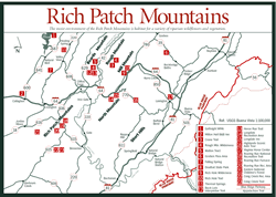
Run Recreation Area [Fig. 23(20)] At the northernmost point of the New Castle Ranger District is one of Jefferson National Forest's best-kept secrets. Roaring Run Recreation Area is located in the Rich Patch Mountains on the George Washington National Forest border south of Clifton Forge and Covington.
The area is steeped with history, both human and natural. The moist environment of the mountain gorge is habitat for a variety of riparian wildflowers and vegetation. In addition, the U.S. Forest Service has constructed attractive facilities and trails. Three interconnecting trails cover some 14 miles of scenic gorges, forested slopes, and mountain knobs with winter views.
Roaring Run Furnace. [Fig. 23(19] Across the creek from the shaded picnic grounds, the remains of Roaring Run Furnace stand quiet and cool in the shadow of the Rich Patch Mountains. In the early 1800s, however, before the first artillery fire of the Civil War, the furnace glowed white hot as sandstone and quartzite containing iron ore from the mountains were fired to 2,600 degrees. Molton iron would flow from the rock into sand trenches to cool, forming ingots for the making of stoves, skillets, and other iron products for nineteenth-century Americans.
Today, trails lead hikers back into the mountain hollows and up the slopes where tram lines once shuttled back and forth to bring out the iron-laden rock. Children pick up marble-sized irregular stones and curiously examine the shiny black and green traces of slag. The colorful slag is man-made glass, a leftover or dross formed during the intense heating of sandstone and quartzite. The refuse is similar to obsidian, a volcanic glass. With its orientation toward the sun and its riparian environment, Roaring Run has the most diverse collection of wildflowers on the New Castle District—an amazing fact considering the area was environmentally terrorized by iron mining and logging. (To keep such furnaces fueled, entire mountains were stripped of their trees.)
Among the flowers to discover here are the beautiful showy orchis (Orchis spectabilis), the crested dwarf iris (Iris cristata), jack-in-the-pulpit (Arisaema triphyllum), bloodroot (Sanguinaria canadensis), black-eyed susan (Rudbekia hirta), trout lily (Erythronium americanum), and many varieties of trillium.
In spring and summer, woodland birds such as the wood thrush, ovenbird, and white-eyed vireo sing from the trees. Pine warblers, worm-eating warblers, blue-gray gnatcatchers, and white-breasted nuthatches are also present. Information boards explain the operation of the furnace, which is listed on the National Register of Historic Places.
Roaring Run National Recreation Trail. [Fig. 23(18)] Roaring Run comes by its name honestly. From the 3,280-foot summit of Montgomery Knob, water comes cascading through a gap in the Rich Patch Mountains, coursing over and around boulders, shooting through flumes, hesitating only briefly in quiet pools in its eagerness to reach Craig Creek. In the most tumultuous sections, a fine mist refreshes hikers on hot summer days.
Its designation as a National Recreation Trail has engendered funding for wooden benches, boardwalks with railings over precipitous or rocky areas, and other construction that makes this short trail a pleasure to walk. However, federal budget cutting leaves in doubt maintenance and any future construction on this and the area's other two trails.
The trail culminates at a picturesque waterfall, where Roaring Run plunges 35 feet over stair-step rock ledges. Below the falls may be a lone angler, working the pools for colorful rainbow trout stocked by the state. Hemlocks that shade the trout pools along Roaring Run, sadly, are dying. The once-beautiful evergreen giants are under attack by the wooly adelgid, an exotic Asian pest. New Castle and Glenwood ranger districts have been hard hit by the predatory insect (see Ghost Forests).
[Fig. 22(5)] Steel Bridge is at the northern tip of Craig County on Potts Creek, just north of Shawvers Run Wilderness Area. Nearby Paint Bank takes its name from the red ochre that nomadic Indians once extracted from the clay soil on the banks of Potts Creek. The pigment was used to color their pottery, clothing, and other artifacts.
 Among
the tribes that frequented these mountains were Monacans, who came from what
are now the southwest Virginia counties of Buchanan, Dickenson, and Wise. To
their south were the Cherokees of North Carolina, and to the north were the
fearsome Iroquois tribes of Pennsylvania and New York.
Among
the tribes that frequented these mountains were Monacans, who came from what
are now the southwest Virginia counties of Buchanan, Dickenson, and Wise. To
their south were the Cherokees of North Carolina, and to the north were the
fearsome Iroquois tribes of Pennsylvania and New York.
The Monacans perfected the art of hiding as the best defense from their enemies. On the thighs of young males entering manhood, the tribe tattooed its symbol of power—not a mountain lion, an eagle, or a wolf but a turtle. Now, instead of the red ochre that once lured Indians to Paint Bank, stocked trout lure modern anglers to deep pools beneath rock overhangs along the banks of Potts Creek. On hot summer days, the cold cascading water tumbling over rock ledges also invites children and adults to wade.
When the fish aren't biting, a trip to Paint Bank Trout Hatchery where the stocked trout are raised is an option. The hatchery is on VA 311, 2 miles south of Paint Bank. Shaded campsites are spread out for .5 mile at Steel Bridge, offering plenty of privacy in a beautiful setting.
 Shawvers
Run Wilderness Area
Shawvers
Run Wilderness Area [Fig. 22(6)] The small Shawvers Run Wilderness Area hides its 3,467 acres in the isolated northern corner of Craig County, about 30 miles northwest of Roanoke. Its terrain is rough and mountainous. Native brook trout draw occasional fly-fishermen to the two Potts Creek tributaries here. Shawvers Run empties out the northeast end of the wilderness while Valley Branch empties out the southwest end.
Hemlock, yellow pine, and white pine provide green in the hollows throughout the year, adding their cool, dark beauty to the narrow rocky canyon through which Valley Branch is funneled. Shadbush, flowering dogwood, serviceberry, and redbud grow beneath a canopy of oaks and hickories on the slopes. Some 10 miles of old roads provide quiet approaches to the heart of this nearly unused wilderness. The roads are not maintained, so following them will mean negotiating downed trees. The Hanging Rock Trail is a popular stop for the few who go out of their way to find Shawvers Run Wilderness Area.
Hanging Rock Trail. [Fig. 22(7)] This short trail climbs then descends to Hanging Rock, a rock outcropping on the northwest ridge of Potts Mountain with outstanding views into Hanging Rock Valley. At the overlook, Shawvers Run Wilderness is northeast. The long wall-like ridge of Peters Mountain can be seen to the northwest.
[Fig. 22(8)] The 5,700-acre Barbours Creek Wilderness covers the rugged southeastern slope of Potts Mountain in the northeastern corner of Craig County. No areas of significant human population are anywhere near this remote country. The majority of use is from anglers who cast for stocked trout in the North Fork of Barbours Creek and hikers who enjoy the peace and seclusion of the wilderness interior. Barbours Creek flows beside VA 617 along the southern border of the wilderness. Forest Road 176 traces the southern boundary of the wilderness.
Red and white oaks, hickories, tulip poplars, and red maples forest the lower southeast-facing slope, while occasional stands of hemlock, rhododendron, and mountain laurel line the creeks and hide in ravines.
Chestnut oak and yellow pines favor the south and west exposures on the drier upper slope. Witch-hazel, flowering dogwood, serviceberry, and sassafras comprise some of the understory. The forest opens at the summit of Potts Mountain to reveal a 50-acre bald. During the 1930s, the summit was cleared for a fire tower which is no longer in use. Once the soil is disturbed, woody plants have a hard time regaining a foothold in the harsh environment of a mountaintop. The bald lies just outside the wilderness border on the southwestern end.
Primitive camping is available at the Pines Campground, where 17 large primitive sites offer plenty of privacy under a forested canopy. The campground serves as a base camp to horseback riders and hikers using the Lipes Branch Trail.
 Lipes
Branch Trail. [Fig.
22(9)] This single yellow-blazed trail, which ascends Potts Mountain along
Lipes Branch, provides both hikers and horseback riders access into the heart
of Barbours Creek Wilderness. The first .5 mile climbs gently up the southeastern
lower slope of Potts Mountain, and then it becomes steeper, using switchbacks
to reach a partially cleared area at the summit with views into Alleghany County
and the George Washington National Forest to the northwest.
Lipes
Branch Trail. [Fig.
22(9)] This single yellow-blazed trail, which ascends Potts Mountain along
Lipes Branch, provides both hikers and horseback riders access into the heart
of Barbours Creek Wilderness. The first .5 mile climbs gently up the southeastern
lower slope of Potts Mountain, and then it becomes steeper, using switchbacks
to reach a partially cleared area at the summit with views into Alleghany County
and the George Washington National Forest to the northwest.
Tinker Creek. Beneath busy Interstate 81 north of Roanoke and unnoticed by travelers zipping up and down the Great Valley of Virginia runs the little stream made famous by Annie Dillard's Pilgrim at Tinker Creek (HarperCollins, 1988).
The creek that drains the abrupt northeast-facing wall of Tinker Mountain flows south past Hollins College and Roanoke to join the Roanoke River on the south side of Vinton. South of the college, Tinker Creek is a stocked trout stream. Dillard wrote a personal narrative full of fresh insights as she explored the natural world of the stream where it flowed through her backyard.
Read and add comments about this page