 The
Natural History of the Virginia Mountains The
Natural History of the Virginia Mountains
The
Natural History of the Virginia Mountains The
Natural History of the Virginia Mountains
The desire to move mountains is a dream as old as the human spirit. Mountain moving, however—or mountain building, for that matter—is best left to nature and time. Take Virginia's gentle mountains. The soft, blue-green folds on the horizon, shrouded in morning mist, appear to have been here forever. In human terms, they have existed for a very long time. In fact, at approximately 250 million years old—100 million more than the Rockies—they've seen their share of birthdays. But there was a time when no forested slopes graced the granite and gneiss bedrock that would someday support Virginia. Eons ago, when Planet Earth was young, events were taking place that would set the stage for present-day life in the mountains of the Old Dominion.
The environment that now supports the white-tailed deer browsing beechnuts on Cumberland Mountain is intrinsically tied to the algae, giant insects, and lungfish that made a home on the planet millions of years ago.
And the ruffed grouse that flushes in a startling whirr on Shenandoah Mountain? Its existence is as closely linked to the first amphibian that crawled from the primordial ooze of the Devonian Period over 400 millions years ago as to the highbush blueberries the grouse ate this morning.
A simple but profound clue to the moving past of Virginia's mountains is in the fossilized seashell embedded in rock at a high mountain pass near the West Virginia line. How did it get there? And why there, and not in the Blue Ridge on Mount Rogers, Big Stony Man, or Old Rag? The answers stagger the imagination.
When geology was a young discipline, scientists studying the earth were intrigued with uncanny similarities in the coastlines of Africa and North America. Like two pieces of a puzzle, the continents appeared as though one would snug neatly into the curvatures of the other.
Speculation began. Could it be? Was it possible that the earth's crust was not fixed in place, but fluid? The idea of continental drift—or plate tectonics—was born.
If giant crustal plates moved slowly across the earth's surface, that would explain a lot of things. Opposing continents also had coastlines with contours that seemed to match up. Rocks on opposite shorelines had a similar composition and similar fossils. Mountains along the edges of some continents looked for all the world like wrinkles from a monumental fender-bender. Deep ocean canyons or trenches off the coasts could be the point where one plate was sliding beneath another. The idea was tempting, but skeptics were many. In North America, the theory became material for jokes. Finally, modern instrumentation lent credibility. Imagine the reaction as scientists began to prove what had lain so simply before their eyes, too fantastic to believe.
Radioactive analysis determined amazing similarities in chunks of rocks on the two seemingly disparate continents. Magnetic analysis gave clues about the original orientation of rock strata in relation to present positions. Analysis of seismic waves revealed the nature of the earth at great depths. Gradually, geologists pieced together some events with reasonable certainty, and formed the basis for making good guesses at others.
Most scientists now believe the world's continents have, inch by inch, drifted together, then broken apart—more than once. At a rate of no more than 5 inches per year, the earth's plates would never win the Indy 500. But these colliding land masses caused unimaginable heat and pressure, torturing and twisting the earth's crust, and crushing or metamorphosing one form of rock into another. Mountains that were pushed up one time would be destroyed the next. From time to time during the earth's restless heaving, shallow oceans would flow in over the land, then withdraw.
Three of these events, or orogenies as they are called, played a part in building the southern Appalachians. The bedrock that underlies today's Appalachians was mostly created during the Grenville Orogeny that began 1.1 billion years ago. Subsequent lava flows from volcanoes that erupted as the continents pulled apart also contributed.
For the most part, the bedrock is invisible, far beneath the sedimentary layers of rock that formed above it after life began. The notable exception is the rock along the eastern edge of the Appalachians. Because it was closest to the point of impact, the bedrock was shoved up and over rock to the west as the plates drifted together again, millions of years after the Grenville event.
This lifeless bedrock, born of fire and crushing force, is there for humans to see and touch. Today, families cast blankets upon it for their picnics. Wildflowers grow in soil pockets on its slopes, and ravens build nests in its crevasses. Climbers cling to its sheer vertical surfaces, bodies pressed against cool granite boulders as hands search for purchase in a niche or indentation. Hikers walk upon this rocky link with ages long past. Hang gliders leap from its upthrust edges, and drift away like feathers to the valley below.
[Fig. 3] Virginia's claim to this Appalachian inheritance includes these four distinct physiographic regions, from west to east:
The Appalachian Plateau rises across the state's extreme southwest corner. Layered sedimentary rock remains for the most part in its original horizontal position. The tough sandstone tabletop has severely eroded over the ages, forming deep, narrow ravines and hollows. The weathering exposes fossils of early marine life in a timeline that goes back through the ages from the top down. Also exposed are seams of coal deposited from the Pennsylvanian Period of the Paleozoic era.
The Valley and Ridge makes up most of Virginia's western province. Folds and blocks of layered rock were turned on their side during the Paleozoic era. The landscape then eroded at varying rates of speed, depending on the composition of the rock, to form the linear mountains and parallel valleys we see today, trending southeast/northwest. Thick deposits of highly erodible limestone from ancient marine life in the Mississippian Period left a heritage of caverns, caves, and sinkholes.
The weathered mountain wall of the Blue Ridge to the east broadens to a plateau in southern Virginia. The Blue Ridge has the state's oldest rock and highest peaks. Here, billion-year-old granite from basement rock was forced up over much younger rock to the west. As the continents pulled apart, the rift action caused volcanoes to spew forth successive lava flows in both southern and northern sections of the Blue Ridge, covering all but the highest peaks.
The rolling foothills called Piedmont have only a few prominent mountains. Mountain-building processes are evident, nonetheless, in the western Piedmont in underlying cracked granites and transformed greenstones.
Despite the age of the Precambrian basement rock, the oldest rocks in Virginia formed nearly two billion years after the first one-celled bacterium cloned itself by simple division in some ancient ocean. Life on earth began about 3.5 billion years ago when primitive algae created pond scum. However, most major groups of plants and animals did not evolve until much later Precambrian times about 2,200 million years ago, as the climate moderated and shallow seas washed over the region that would one day be called Virginia.
By the Cambrian Period (about 480 to 600 million years ago), deposits of the first insectlike animals called trilobites began settling to the ocean floor. Then tiny animals called graptolites added their remains to the flooded deltas of the next period—the Ordovician (about 435 to 480 million years ago). Decomposing Ordovician gases led to the formation of oil, lead, and zinc in layers of limestone, sandstone, and shale.
Then came spore-bearing land plants and coral reefs from the Silurian Period. In subsequent ages, remains of great varieties of Devonian fishes, then Mississippian mosses and Pennsylvanian reptiles, settled on top of earlier sediments, much the way colored sands stratify in a jar.
As life was taking on more complex forms, massive collisions occurred again, crushing the sedimentary layers with increasing intensity nearest the point of impact. To the west, however, the layers remained intact.
About 450 million years ago, the Taconic Orogeny crumpled the eastern edge of the North American plate, forming granite at the edges. Mountains began to build, only to be destroyed by the next crushing event. A hundred million years later, the eastern edge of North America felt the impact from another slow-motion event called the Acadian Orogeny. Most geologists believe the latest collision occurred near the end of the Paleozoic Era, about 250 million years ago, and pushed the southern Appalachians into being. A mass called Laurussia, composed of North America, Greenland, and Europe, drifted together over a period of 50 million years with another supercontinent called Gondwana, composed of Africa, South America, and India.
Faults, or fractures, appeared toward the east coast, and great blocks of layered rock thrust themselves up and over other blocks, or were crumpled into folds. For a time, earth's continents existed as one large mass called Pangaea.
About 220 million years ago, say scientists, this supercontinent began to break up. As the breach grew wider, the Atlantic Ocean was born.
The sea waters rolled back over time to reveal the Appalachian Mountain system. The new range stretched from central Alabama 1,500 miles northeastward to the Gaspe Peninsula in Quebec, Canada. Many geologists take the range even farther, to the Labrador Sea, where the ridge disappears into the ocean about 15 miles north of Newfoundland. Before the weathering effects of wind and rain subdued our nation's oldest mountains, the Appalachians possibly soared to the dizzying heights of the modern Himalayas. Although erosion and time would change their appearance, the groundwork was laid.
Now the stage was set. Decayed Paleozoic marine life and newly formed mountains provided the script for the nature of things to come. The direction of a single drop of rain in Virginia, for instance, is determined by the aged Appalachians. On eastern slopes, a falling raindrop will end up in the Atlantic. But to the west, it will take a much longer route, transported by several river systems to spill finally into the Gulf of Mexico.
The residue of rich marine life, lifted high above the valleys on budding mountains over the millennia, came to support complex ecosystems of various natural environments with diverse collections of plants and animals. Examples of these environments are boulderfields, hardwood forests, hemlock and heath forests, bogs, and limesinks.
Not only have Virginia's mountains been a key player in determining natural history, but they've shaped the course of human events as well. In the Valley and Ridge province, farmers found lush deltas. Layers upon layers of plants and animals deposited by early seas put corn and cabbage on their tables. The chance orientation of layered rock beneath the surface, however, could result in poor soil in an adjacent valley, where families would struggle to survive.
The coal that formed mostly from decaying woody plants crushed in Appalachian Plateau sandstone markedly influenced human settlement in southwest Virginia, where coal was king for many years. In fact, coal is still the most valuable mineral resource in the state.
Mountains born of continental drift partitioned Indian tribes and hunting grounds and delayed westward expansion of pioneers. These nearly impenetrable ranges funneled farmers and settlers from the North southward to fertile valleys, and became the scene of bloody Civil War battles. They inspired sonnets from the British and made Scots-Irish farmers homesick for their own highlands.
Today these seemingly eternal hills provide recreation for the city-weary, solace for the troubled, and a home for things wild and free. The stuff of our mountains—from inanimate rocks to vibrant life forces—flows from one eon to another in an ever-changing tapestry. From the oceans came life, developing from microscopic, one-celled simplicity to a creature equipped with backbone and lungs and able to crawl ashore, to an upright being that can devise a spaceship capable of riding a tail of fire to other planets.
The prescription for this life contains a simple rule—that every living thing must die, to decay and return its minerals to form the rocks of the earth. Nowhere have the threads of this natural cloth been more intricately woven, more beautifully blended, than in the primeval mountains of Virginia.
 The
Mountain Ecosystem
The
Mountain Ecosystem The forests of Virginia's mountains are in transition. Like a patient brought out of intensive care, the condition is guarded. The trouble, it seems, stems from the forests' very desirability. Even before white settlers arrived, Native Americans manipulated the forests and its wildlife. The Shenandoah Valley—a popular hunting ground for various nomadic tribes—was repeatedly burned to provide grasslands for herds of bison and elk. Big Meadows in Shenandoah National Park was probably kept open with regular burnings to provide forage for elk and deer and to simplify the gathering of chestnuts.
For a time, forested slopes, where soil was thin and poor, were left for the most part with their cover of magnificent chestnuts and oaks. As early settlers claimed the lush farmlands in the valley, however, newcomers were forced to stake out less-desirable sites on mountains. They cleared land for crops and pasture, but the steep slopes quickly eroded and became too poor to farm. Families would abandon the depleted soil and move higher up the mountains. The demand for iron, copper, and manganese during the Civil War further stressed the resources. Iron and manganese furnaces sprang up throughout the forests, and operators cut every usable tree within dragging distance to keep the fires stoked. Many trees not removed for mining were hauled away by railroad for lumber.
Finally, visitors to the mountains became alarmed at the devastation. A preservation movement got under way at the eloquent urging of such naturalists as Henry David Thoreau, author of Walden, and John Muir, founder of the Sierra Club.
An early champion of the conservationist movement was Gifford Pinchot, who became the first chief of the U.S. Forest Service. In 1911, Pinchot wrote: "No one can really know the forest without feeling the gentle influences of one of the kindliest and strongest parts of nature. From every point of view it is one of the most helpful friends of man. Perhaps no other natural agent has done so much for the human race and has been recklessly used and so little understood."
Pinchot and President Theodore Roosevelt worked to bring wounded and abandoned lands under the protection of the federal government. In 1917, the George Washington National Forest was established, as the federal government bought and set aside "the lands nobody wanted."
Among the devastating effects of logging the mountainsides without restraint were massive flooding and erosion in the Tennessee Valley drainage west of Virginia's Plateau province. In 1936, the U.S. Forest Service bought land for the Jefferson National Forest's Clinch Ranger District in southwest Virginia, largely to protect the headwaters of the Tennessee River from the disastrous effects of denuding the land of trees. In the same year, Shenandoah National Park was opened in the Blue Ridge Mountains. Wildlife also suffered greatly from the removal of tree cover, from silted streams, burnings, and unconstrained killing. Indians, after acquiring firearms, killed off the last woodland bison in the southern Appalachians by 1760. Elk disappeared in the mid-1800s. Settlers quickly extirpated gray wolves, red wolves, and cougar without a second thought.
With no restraints, they also shot black bear, white-tailed deer, wild turkey, and bobcat, and trapped otter, beaver, and other furbearers. Elk, wolves, and bison never recovered. Though no concrete evidence proves the return of cougar (mountain lion), reliable sightings continue to trickle in, especially from high, remote areas of the Blue Ridge. The Peaks of Otter on the Blue Ridge Parkway is a frequently named locale. White-tailed deer, wild turkey, and black bear have been restored to much of their former range—success stories for wildlife management. Ironically, the return of these animals has been funded almost solely by hunters and anglers. Modern wildlife management has also enabled bobcat, beaver, and otter to make a comeback at some locations. Improving habitat for game animals has coincidentally benefitted many other species.
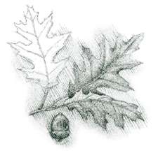
The American chestnut (Castanea dentata) once made up 40 to 50 percent of southern Appalachian forests. Nearly pure stands covered some forest slopes. The tree is a fast grower, and will grow most anywhere except in a swamp. The reddish-brown wood is lightweight, straight-grained, and easy to split. The trees grew 120 feet high and 10 feet across—trunks wide enough to fill most people's guest bedroom. Today's basketball players could stretch out on a stump and not touch the sides.
Chestnut wood was almost impervious to rot. Consequently, the tree was perfect for homes, barns, rail fences—anything that had to withstand sun, wind, and rain. Woody debris from downed chestnuts would last for decades, and added stability to the headwaters of streams. Both people and wildlife relished the sweet nut. Indians boiled the nuts to make stew, and colonists from England pickled them, used them in stuffings, and ground them into flour.
However, a fungus, Cyphonectria parasitica, introduced into New York from China in 1906 quickly spread throughout the chestnut's domain, ravaging the forest giants. None was immune. In Virginia, the tree was wiped out between 1910 and 1934. In 40 years, the chestnut blight killed 3.5 billion trees. The loss of the tremendous annual mast crops had a severe effect on mammals that depended on the tree for food. Especially hard hit by the demise of the chestnut were residents of the Appalachians, already besieged by hardships of the Great Depression. Resourceful mountaineers had found uses for every part of the tree—the wood, the nuts, even the bark. They also lost a prime source of income derived from hauling the wood and wagonloads of nuts to market.
The blight does not damage the tree's root system, and hope stays alive in new shoots that spring from old roots beside decaying stumps. Saplings appear healthy at first. As the trunk attains a 3-to-5-inch diameter, the rusty-red blight is evident on the bark. The tree sometimes becomes large enough to produce the tasty nuts in their prickly burrs before succumbing to disease. In fact, the chestnut is still a common understory tree. Unless scientists can develop a blight-resistant strain, though, the once-mighty chestnut is relegated to the status of underling.
More than a half century since the last tree succumbed to blight, the loss of the American chestnut from the forest continues to have an impact. Watersheds of the Appalachians are in the process of reestablishing an equilibrium. Woody debris that once stabilized streams is missing. Other riparian shade trees that might have replaced the chestnut as a stream stabilizer are fighting their own battles with disease. The Eastern hemlock, under assault by the wooly adelgid, is the most notable example.
The health of a watershed is important, among other reasons, for its natural response to large floods that sometimes accompany hurricanes. A healthy watershed is resilient and can recover rapidly, but a watershed under stress from past or current land use may suffer disproportionately with longer periods of recovery.
Many of Virginia's mountainous areas are now public lands. The George Washington National Forest [Fig. 25], established in 1917, covers more than a million acres. The GW extends for 140 miles along the Appalachian Mountains of northwestern Virginia and spills over into West Virginia. Four wilderness areas protect 32,000 acres from development.
The U.S. Forest Service created the Jefferson National Forest [Fig. 15] in 1936 on the southern end of the George Washington. The 705,192 acres of the Jefferson spread across the mountains of southwest Virginia. A small portion also spills across state lines into West Virginia and Kentucky. The Jefferson has 11 wilderness areas with a total of 57,000 acres.
Although legislatively considered two separate forests, the George Washington and Jefferson were combined in March 1995, for administrative purposes. Headquarters for both are located in Roanoke under the name George Washington and Jefferson National Forests. The National Forests are managed for multiple use, including timber production, recreation, hunting, and fishing.
Mount Rogers National Recreation Area (NRA) [Fig. 34], in Virginia's southern Blue Ridge Mountains, is a 115,000-acre area of the Jefferson designated expressly for public enjoyment.
The National Park Service administers three areas in Virginia mountains—Shenandoah National Park [Fig. 43] and the Blue Ridge Parkway [Fig. 37, Fig. 38], both in the Blue Ridge Mountains [Fig. 32], and Cumberland Gap National Historical Park [Fig. 7] in Virginia's southwestern tip.
The state has eight state parks in the mountains and foothills. These include Hungry Mother [Fig. 19], New River Trail [Fig. 50], Grayson Highlands [Fig. 33], Claytor Lake [Fig. 51], Fairy Stone [Fig. 36], Smith Mountain Lake [Fig. 39], Douthat [Fig. 28], and Sky Meadows [Fig. 45]. In addition, Breaks Interstate Park [Fig. 11] on the Kentucky border is shared by Virginia and Kentucky.
The Virginia Department of Conservation and Recreation (DCR) administers the parks and an ever-increasing number of Natural Area Preserves. The preserves, under the DCR's Natural Heritage Program, are designed to protect the habitat of rare, threatened, and endangered plant and animal species and rare communities and ecosystems. Most do not have facilities for public access.
The Virginia Department of Game and Inland Fisheries operates 29 Wildlife Management Areas (WMA) for wildlife habitat, hunting and fishing, wildlife viewing, hiking, and protection of unique plant communities. Of 180,000 total WMA acres, 123,000 are in the mountains. In addition, the Appalachian Trail and other long trails [Fig. 46] provide hikes through scenic portions of the state. Several navigable rivers and scenic byways add more options for enjoying the outdoors in the mountains of the Old Dominion.
Ghost forests. What's eating the trees? The question is a common one, say park rangers and forest rangers. Usually the curiosity stems from sights of large areas of gray, bare trees—a "ghost forest" in the midst of summer's greenery. The answer, most often, is the gypsy moth.
Although this exotic pest is the most destructive at present, the forest must deal with many other diseases and pests, both native and exotic. These include the hemlock wooly adelgid, pine beetle, dogwood anthracnose, fall cankerworm, and balsam wooly adelgid, all discussed below. A disturbing decline in the health of oak trees is also under study. In addition, butternut is under attack by the butternut canker, American elms are killed by Dutch elm disease, and table mountain pines—dependent on fire for restoration—are declining because of damage by bark beetles and the absence of fire for recovery. Foresters note the successful reforestation of cutover land and former agricultural land, watershed improvement, erosion control, fire protection, and expansion of wildlife populations that were priorities during the first half of the 1900s. Following an intensive study by state and federal agencies called the Southern Appalachian Assessment, new focuses include the possible development of gene conservation to protect declining tree species and improve the resistance of Eastern and Carolina hemlock, American chestnut, and butternut to insects and diseases.
Gypsy moth. Defoliated mountainsides have become an increasingly familiar scene over the past decade. Just as forest trees are leafing out in spring, hungry gypsy moth caterpillars are hatching and going to work on them. In heavily infested areas, entire slopes are denuded of foliage. Caterpillar droppings (frass) rain from the trees and cause an overwhelming stench. The trees usually leaf out again, although the leaves are lighter and smaller. Repeated defoliation stresses trees and eventually will kill them.
The gypsy moth made its way to America in 1869 courtesy of Etienne Leopold Trouvelot, who was attempting to find a better silk moth and make a few bucks. The moth escaped into the New England countryside where it had no natural enemies. It took more than a century to make its way to Virginia. But between its first appearance in 1980 and today, it has become a household word in the Commonwealth.
The pest crept southward, county by county, despite extensive attempts to halt its progress with sprays, pheromone (chemical attractant) traps, burlap rings applied to trunks to trap the caterpillars—everything short of incantations and magic potions. But in 1996 and again in 1997, an amazing occurrence gave the forests—and homeowners—a break. A fungus (Entomophaga maimaiga), first introduced in the early 1900s, mysteriously reappeared and devastated the gypsy moth population in Virginia. Incredibly, no areas experienced defoliation.
For the moment, the gypsy moth is no more abundant than other moths. However, entomologists warn that the fungus may have its own boom and bust years, just as the gypsy moth does. Although subdued, the moth lives on and the Virginia Department of Agriculture and Consumer Services notes the continual spread southward.
Oak decline. The health of oak trees is declining in the southern Appalachians, even in areas not yet affected by the gypsy moth. State and federal agencies studying the problems attribute the decline to many factors, including drought, disease, advancing tree age, and insect damage.
Oak decline causes reduced growth, crown dieback, and, after several years, mortality. Members of the red oak group (northern red, black, and scarlet oaks) are more susceptible than those in the white oak group (white and chestnut). Damage is more common in areas of poor, thin soil. Oaks stressed by drought, gypsy moth defoliation, or other factors may then become susceptible to shoestring root rot, a fungus root-decay pathogen native to North America and found throughout eastern forests. The oak is the tree that largely filled the vacuum after the demise of the American chestnut. The tree contributes to many complex ecosystem processes including the cycling of nutrients, the dynamics as a dominant canopy tree in a stand, and forest succession. Acorns are eaten by many wildlife species and are a staple in the diet of white-tailed deer, wild turkey, black bear, and gray squirrel. A black bear study, however, indicated these opportunistic animals would turn to grapes that grow in the sunlight under a destroyed oak canopy.
Oak is also a prime tree for the timber industry. Obviously, its decline has serious implications for the forests.
Hemlock wooly adelgid. The hemlock wooly adelgid, a major exotic pest in the Glenwood and New Castle ranger districts of the Jefferson National Forest [Fig. 14] for several years, is expanding its range in the national forest. Virtually all major stands of hemlock on the Glenwood are infested, and the adelgid is progressing south. To the north, Shenandoah National Park [Fig. 43] also has infestations.
While feeding, the insect injects a toxic saliva into hemlock foliage. The needles turn brown and drop from the tree. Over the years, the tree loses its foliage from bottom to top. After hatching from an egg, the insect is easily spread by wind, birds, deer, and other forest animals. This pest introduced from Asia has no natural enemies and has the potential of killing all hemlocks in the forest. Several varieties of foreign ladybird-beetles are under consideration for release as a biological control.
Hemlock, which grows along streams in sheltered hollows, is valuable as a shade tree for cold-water fisheries and for wildlife cover. The tree is the main component in several beautiful stands of old growth forests. Some hemlocks in the Limberlost of Shenandoah National Park are 350 to 400 years old.
Southern pine beetle. The southern pine beetle prefers hard pines, particularly loblolly, pitch, shortleaf, table mountain, and Virginia pines. A serious outbreak of the pest between 1991 and 1993 on the Glenwood Ranger District of the Jefferson National Forest [Fig. 15] affected even white pines, which are normally resistant. The outbreak ended following extremely cold temperatures during the winter of 1993—94, which killed most of the beetles.
Cutting the effected trees can stop infestations of southern pine beetles. Biological control methods include making the habitat suitable for parasites and predators of the beetles. Insecticide sprays are another option.
Dogwood anthracnose. Dogwood anthracnose is a fungal disease that causes leaf spots and stem cankers and can kill shoots and stems of flowering dogwood. Since it was first reported in the late 1970s, the fungus has become widespread in the eastern United States. It has been found in every county within the southern Appalachians.
Dogwoods at high elevation in shaded sites are at greatest risk and have little resistance. Anthracnose has no known natural enemies, and there are no practical methods for its control. In some areas, all the dogwoods have already been killed. Flowering dogwood—with its welcome sprinkling of white blossoms in the drab forest understory in early spring—is an important source of soft mast for wildlife.
Fall cankerworm. Fall cankerworm is one of the more common and injurious of the many species of loopers, spanworms, and inchworms that attack eastern forests.
The species will typically hatch in late April or early May, when leaf buds begin to open. Young larvae then feed on the buds and unfolding leaves. Hikers may notice defoliation and hear the sound of raining frass, or excrement, from the larvae. These larvae drop from the leaves on silk strands. Wind often detaches them and blows them great distances. Four to five weeks after hatching, they enter the soil to pupate, usually in early June.
An infestation in the Pedlar Ranger District [Fig. 25] of the National Forest on the east slope of the Blue Ridge Mountains is being monitored by the U.S. Forest Service.
Balsam wooly adelgid. The balsam wooly adelgid is attacking all but a few stands of Fraser fir in boreal forests on high summits in the southern Appalachians. The insect injects a deadly secretion as it feeds below the bark. The nearly pure stands of Fraser fir in Mount Rogers National Recreation Area [Fig. 34] are unaffected, while firs elsewhere are being decimated. Foresters have recently discovered that the Mount Rogers fir produces outer bark at a higher rate than fir elsewhere.
Scientists are studying the phenomenon, trying to develop resistant strains. Cones of seeds from Mount Rogers trees are sought by Christmas tree growers for their resistance to the adelgid.
Visitors to Virginia's parks and forests may also notice areas of severe destruction caused by both nature and humans. Examples are eroded areas, blow-downs, washed-out ravines, and standing deadwood. Such scenes may result from past logging operations (erosion), hurricane-force winds (blow-downs), ice storms (stands of broken and dead trees), or flooding rains (debris-strewn ravines, streams, and river valleys).
Fire—used by Native Americans and European settlers—may have altered forest dynamics for hundreds of years, according to a study called the Southern Appalachian Assessment. Fire prevention and suppression in the twentieth century, therefore, has changed a long-term pattern, and there are ecological consequences.
Fire—or its suppression—is probably the most common form of natural disturbance in the southern Appalachians. Its effects on southern yellow pines are well understood. It was probably a major factor in the development of oak forests on upland sites, but its ecological effects need further study.
Historically, forests with healthy ecosystems respond well to natural disturbances—even depend on them sometimes. A healthy watershed, for instance, is resilient and can rapidly recover from the effects of a large flood. Trees killed by lightning or downed by wind are used by various birds, animals, and insects for shelter or food.
But disturbances not built into the dynamics of the ecosystem may result in a much slower recovery. Besides the use or suppression of fire, other examples of disturbances include the many logging and tram roads pushed into the forest during the 1800s and early 1900s, strip mining, unmanaged tree removal, and the practice of bulldozing streams to straighten and widen them (channelization). Streams carrying water from steep mountainsides normally run clear until they pass areas where the soil has been disturbed. Only then do they pick up a cloudy green or brown tint.
Nature produces an extremely tough forest floor, full of nutrients and nearly impervious to erosion, no matter how severe the storm. But soil-building takes time. At one inch every 50 to 100 years, the process is often too slow relative to the needs of humans for forest products.
The U.S. Forest Service must continually weigh human needs against the needs of the forest for recovery.
 Diversity
in the Southern Appalachians
Diversity
in the Southern Appalachians The southern Appalachians harbor the most diverse plant life in the temperate region of the world. More than 130 species of trees and 2,250 vascular plants grow in the region. Field scientists have identified 175 species of terrestrial birds, 65 species of mammals, and an estimated 25,000 species of invertebrates.
The diversity of crayfish, snails, and freshwater mussels in the Southeast is greater than in any other part of the world, and much of the diversity is in the southern Appalachians. The region also has more species of fish than any other place in the country. The watershed for the Tennessee River—much of which lies in Southwest Virginia—has especially high concentrations of these aquatic species.
A combination of factors contributes.
First, the abundance of plant life is partly attributable to mild climate and plentiful rain. The southern Appalachians receive the second highest amount of rainfall in the country, topped only by the rain forest of the Pacific Northwest.
Species richness is also a result of overlapping northern and southern habitats. Many southern species—Carolina hemlock (Tsuga caroliniana), Fraser fir, persimmon, pawpaw, mud salamander, and narrowmouth toad, to name a few—reach the northern extent of their range in the mountains of the southeastern United States.
Conversely, numerous plant and animal species native to New England and Canada extend their range southward down a fingerlike corridor of the Appalachians. Examples of Virginia's high-country species borrowed from northern climes are northern wood sorrel, bigtooth aspen, mountain-ash, red squirrel, red-breasted nuthatch, saw-whet owl, and golden-crowned kinglet.
Actually, northern species had a bit of help. During the last ice age of the Pleistocene epoch some 10,000 years ago, glaciers reached only into Pennsylvania, stopping short of Virginia. Northern species of plants and animals migrated south with colder temperatures, ahead of the ice sheets. The southern Appalachians served as a refuge until the glaciers finally began to melt, retreating north. Certain forest communities found the high altitudes in the mountains hospitable even after the ice age was over, and they remain today.
An example of the effects of glacier-induced species migration are the boreal forests in the rarified atmosphere of summits above 5,000 feet. In Virginia, such forests cover the summits of high peaks in Mount Rogers NRA [Fig. 34] in the southern Blue Ridge [Fig. 32] and peaks in the Laurel Fork area [Fig. 25] (Warm Springs Ranger District) of western Highland County.
The endangered northern flying squirrel (Glaucomys sabrinus fuscus) inhabits the forests in both areas. At Laurel Fork, the diminutive, nocturnal mammal leaps and glides from bough to bough in the isolated patches of red spruce and northern hardwoods that rode the ice flows southward. The rich, decaying soil beneath the conifers produces fungi, mushrooms, lichens—the diet of the northern flying squirrel. Sharing the same forest are other remnants from the ice age—the snowshoe hare, the fisher, and the paper birch (Betula papyrifera).
Extremes in altitude also enhance species diversity. Each 1,000 feet in elevation is accompanied by a 3.6-degree Fahrenheit decrease in temperature. A 6,000-foot increase in altitude is similar to driving 1,000 miles north. A trip from the James River, at an altitude of 650 feet, to the 5,729-foot summit of Mount Rogers in Virginia's southern Blue Ridge is the rough ecological equivalent of a drive from the James River to the shores of Canada's Hudson Bay.
Depending on the route to Mount Rogers, the traveler would pass through a variety of forest communities. These might include a silty lower floodplain, wetlands and bogs, cove hardwoods, shale barrens, oak-hickory forest, oak-pine forest, northern hardwoods, grassy balds, boulderfields, and muskegs, ending in an alpine spruce-fir forest. Each community has plant and animal species especially adapted for survival.
A key component for determining which species are found in various communities—but certainly not the only determining factor—is elevation. Other criteria are orientation to the sun, moisture, competing species, soil nutrients and textures, and pure luck. The fate of a seed eaten by a blue jay or a berry eaten by a cedar waxwing is dependent on the bird's itinerary for dispersal.
Salamanders. So many species of salamanders occur in the southern Appalachians—34 at last count—that many scientists now believe the region is the center for salamander evolution. Shenandoah National Park [Fig. 43] has 17 species. The Mount Rogers NRA has 26. In the Mount Rogers/Whitetop area, 20 species live on approximately 2,000 acres—the greatest known diversity of salamanders in an area of this size on earth. Several varieties are found nowhere else in the world.
One explanation for the diversity is the region's high precipitation. Salamanders must stay moist to keep their sensitive skin from drying out.
The isolating effect of the mountains also contributes to the variety and rarity of species. As temperatures warmed following the last ice age, salamanders probably migrated gradually up the mountainsides to find cooler habitat. Finally, separated from one another on various summits by now-inhospitable valleys, salamanders evolved into many distinct species. The Shenandoah salamander lives at just three sites on the north and northwest-facing talus slopes above 2,900 feet in Shenandoah National Park. Because Plethodon shenandoah cannot survive at lower altitudes, and cannot compete with the red-backed salamander (Plethedon cinereus) in woodlands surrounding the talus, it has no way—short of sprouting wings—to migrate to other talus slopes on other mountains.
So specific are many of the habitats where various members of these caudates have evolved, the salamanders have been named for particular mountains or summits. Examples are the Peaks of Otter salamander, the Cow Knob salamander, and the Roanoke Mountain salamander.
A complex eastern deciduous forest covers 70 percent of the Southern Appalachians. Approximately 30 percent is unforested. Common trees are oak, beech, birch, hickory, walnut, maple, basswood, elm, ash, tulip, and hornbeam. Most of the forest has been cut over several times since white settlers arrived.
The deciduous forest includes several major forest types with many combinations, variations, and mixes of successional stages. Basic to the Appalachians in Virginia are oak-hickory, cove hardwood, northern hardwood, spruce-fir, and oak-pine. Fallow fields, woodland edge communities, streams, marshes, swamps, bogs, glades, grassy balds, boulderfields, and shale barrens add variety. Many of these communities—some listed as rare—are discussed throughout the book. Two of the most common forests in Virginia—oak-hickory and cove—are described below.
Oak-hickory forest. The thin soils on the majority of forested dry mountain slopes of the southern Appalachians are dominated by an oak-hickory forest. The canopy is composed of northern red, white, black, scarlet, and chestnut oaks, along with white pine, pignut hickory, shagbark hickory, mockernut hickory, bitternut hickory, sourwood, and black walnut. Oak-hickory forests have replaced the former chestnut-oak forests. Though forest canopies are often dominated by just two nut-producing tree groups—oaks and hickories—a rich variety of other species grow in the understory. Some of the more common understory trees and shrubs include flowering dogwood, mountain laurel, red maple, witch-hazel, redbud, shadbush, highbush blueberry, deerberry, and azalea.
Nuts produced by oak-hickory canopies—or hard mast, as they're called collectively—support black bears, white-tailed deer, wild turkeys, blue jays, gray squirrels, Eastern chipmunks, and raccoons.
Cove hardwood forest. A forest community unique to the region is the Appalachian cove hardwood forest. In the rich, moist soil of sheltered coves and bottomlands are stands of lush hardwood forests where towering white or American basswoods, tulip poplars, Eastern hemlocks, and yellow buckeyes gradually rise to heights of 80 to 120 feet.
Songbirds, wildlife, ferns, wildflowers, understory trees, and shrubs are diverse and abundant in cove forests. Unlike the oak-hickory forest prevalent throughout most of the Appalachians, the cove forest may have six to eight tree species that share dominance.
High in the canopy, a brilliant scarlet tanager sings, and the great-crested flycatcher darts out from a snag to snatch an insect from midair. A slanting ray of sun piercing the thick canopy in a mature cove forest might briefly reflect the red crest and black-and-white wings of the wide-ranging pileated woodpecker. The pileated may defend an area of 150 to 200 acres, dependent on large trees of mature forests for a continual supply of carpenter ants.
Before the canopy of a cove forest grows too thick, a dense understory houses another array of birds, including the colorful hooded warbler. Close to the complex, multilayered, spongy soil are the often-overlooked smaller creatures such as mice, salamanders, lizards, frogs, snakes, and insects.
Cove forests, valued for timber production, are rarely left undisturbed. However, occasional stands of this type are in nearly inaccessible places such as pockets of remote wilderness areas or rich bottomlands between high ridges. Some cove forests that escaped the logger's axe in the 1800s and early 1900s remain untouched today. Outstanding old growth forests are the result.
Huge, widely spaced trunks of virgin timber disappear into a thick, layered canopy. In the dimly lit understory lie decaying hulks of former giants of the forest, their dark outlines softened by carpets of ferns and mosses. Mushrooms and fungi sprout from softened bark; ants and beetles work busily in the interior.
Old growth—formerly considered a forest past its prime and with little value for wildlife—is coming under closer scrutiny. The importance of woody debris to aquatic ecosystems is one area of study. The debris provides a slow release of nutrients to both soil and stream and stabilizes streambeds during periods of high water. High levels of important nutrients—nitrates, sulfate, phosphate, calcium, magnesium, and organic carbon—are available for new growth.
Summer temperatures on a hot day can be 10 degrees cooler in the naturally air-conditioned old growth forest. When soils are saturated, a single large oak can draw 3,000 gallons of water from the ground in a day. The value of these and other benefits of old growth are being weighed against the demand for timber and the philosophy of forest renewal through periodic harvesting. Old growth cove forests are complex factories with hundreds of years of experience at filtering water and air, harnessing solar energy, building soil, recycling waste, and providing a controlled release of minerals from the underlying rock base.
In Virginia, examples of these rare stands of cathedral-like forests still exist in Rich Hole [Fig. 23(6)] and Ramsey's Draft wilderness areas and in Shenandoah National Park [Fig. 43].
 Mountain
Magic
Mountain
Magic It's difficult to speak of mountains without superlatives. In human reckoning, everything about them—their age, their size, the forces required to create them—is grandiose.
The immensity and scope of mountains, of course, are part of their appeal. Like the forces that created the universe, we speak of mountains in time frames with little relevance to anything human. Words and phrases such as eons, millennia, billions of years, continental drift, and orogenies are our best efforts to describe what perhaps can only be comprehended in relative terms, even by scientists themselves.
Yet unlike the heavens, mountains are touchable. We walk upon them, sift their living soil through our fingers. We feel the wind they create on a ridgetop or the cool air that sinks down a ravine. We hear the hollows play with a roll of thunder.
Maybe what mountains do best for their human admirers is to create a physical bond with forces too great to comprehend with the mind. With our feet on the ground, they lead our eyes to the stars and link us with the primeval grandeur of the universe.
Read and add comments about this page