 Pine
Mountain Pine
Mountain
Pine
Mountain Pine
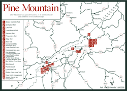
Mountain [Fig. 8, Fig. 5(8)] This 125-mile-long mountain teamed up with the parallel ridge of Cumberland Mountain to the east to bar early explorers and pioneers from traveling west. Together, the two mountains, like side-by-side folds in a blanket, march northeast from east Tennessee into east Kentucky and southwest Virginia in a duo jointly called the Cumberland Mountains.
Near Jellico, in east Tennessee, a stream called Clear Fork breaks through the ridge to define the southern end of Pine Mountain. About 35 miles northeast, the Cumberland River only briefly interrupts the ridgeline where it breaks through at Pineville, Kentucky. The Russell Fork of the Big Sandy River [Fig. 8(21)] in Virginia defines the northern end of Pine Mountain in dramatic fashion as the river circles 600 feet below a pyramidal sandstone formation called The Towers. The Russell Fork almost comes back to touch itself as it carves its way through the mountains, then takes off for the Kentucky border to the west. Through the same gorge passes the CSX Railroad, visible testimony to the Herculean task engineers and work crews faced in the early 1900s. In a feat that involved cutting four tunnels and two bridges through the nearly impenetrable sandstone, they opened the mountains to coal mining and connected the Ohio Valley and Midwest to the Atlantic seaboard.
Pine Mountain was formed when tremendous pressure from sliding plates beneath the earth's crust forced the rocks on the Virginia side up over those on the Kentucky side along the Pine Mountain fault. Though the mountain was formed at the same time as the rest of the Plateau province, its long, linear shape is more characteristic of the mountains of the Valley and Ridge province to the east. The Pennsylvanian sandstone of its upper layer, however, gives its origin away.
When hiking the trails on the southeast slope, visitors may come abruptly to harsh fields of sandstone boulders, where plant life claims a tenuous foothold. Where piles of these rocks form caves, Indians and wildlife found shelter. Mixed Appalachian hardwoods interspersed with pines cover the mountain. Private landowners on the steeper Kentucky side, however, are familiar with the large patches of exposed Greenbrier limestone. This Mississippian Greenbrier limestone is younger than the Cambrian-age limestone of the Valley and Ridge by at least 140 million years.
The public land on the Virginia side of Pine Mountain in Wise and Dickenson counties is a well-kept secret. In this remote section of southwest Virginia are thousands of acres of national forest, an interstate park, drives with incredible scenery, and two immense lakes inviting those who enjoy water sports.
Whether they're speaking of the hiking trail, the scenic drive, or the mountain itself, many local residents refer to Pine Mountain as Cumberland Mountain. Indeed, Pine Mountain resembles the long, parallel ridge of Cumberland Mountain. Pine Mountain also defines the Virginia border with Kentucky in Wise and Dickenson counties, just as Cumberland Mountain defines the Virginia/Kentucky border in Lee County in Virginia's southwest corner.
With modern maps and satellite photographs, it's easy to see that Cumberland and Pine mountains are distinct and separate. But early settlers in Wise and Dickenson counties had little way of knowing the ridge between themselves and Kentucky was not Cumberland Mountain, but was actually a parallel ridge 25 miles west of Cumberland. Once a name is used for centuries, it sticks.
[Fig. 8(12)] Whether it's called Pine Mountain Trail (official U.S. Forest Service name) or Cumberland Mountain Trail (used by local residents), the 22.8-mile scenic path along the rugged spine of Pine Mountain attracts hikers who enjoy solitude and a challenge. The trail connects Pound Gap where US 23 crosses Pine Mountain in Wise County with Breaks Interstate Park in northern Dickenson County.
The hiker will travel beneath a hardwood forest canopy, passing many rocky outcroppings with panoramic views of Kentucky and Virginia. In fall, not only is the foliage spectacular, but this ridge is a fine vantage point for watching the annual migration of hawks and other birds of prey. Horseback riders can use the trail, but there are rocky sections on both ends too treacherous for a horse. Many riders make a 9.5-mile loop hike by combining VA 611, FR 2071, and FR 616 with Pine Mountain Trail. A newly developed parking area at Counts Cabin (junction of VA 611 and FR 2071) has room for horse trailers. To find the parking area, from Clintwood in northwestern Dickenson County, go 2.5 miles north on VA 631 to Isom. Then go northeast on VA 611 about 4 miles to parking area.
All of the loop is public property. However, many other parts of Pine Mountain Trail pass through private tracts, often with no posted signs or boundary markers. Hikers should respect the rights of property owners and carry trail maps, which can be obtained at the Clinch Ranger District office. Also, because of the isolation of the area, be sure to carry adequate water, extra clothing, and a first aid kit.
Read and add comments about this page