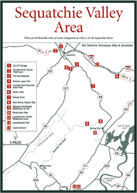
The Southern Division of Bowaters, Inc., a company that owns more than 350,000 acres of timberlands in Tennessee, began establishing pocket wilderness areas within its holdings in 1970. There are seven sites, all designated as state natural areas.
[Fig. 16(2)] This 317-acre parcel of land owned by the Southern Division of Bowaters, Inc. was the first pocket wilderness area the company opened in Tennessee. The main attractions in the area are the waterfalls that plunge from considerable heights: Big Branch Falls, Sheep Cave Falls, Big Laurel Falls, and Virgin Falls.
The sensational Virgin Falls emerges from a cave and drops 110 feet. Virgin Falls is located on the western edge of the plateau 8 miles south of DeRossett off US 70 between Crossville and Sparta.
[Fig. 16(1)] This scenic trail offers hikers a wide variety of features, including three waterfalls, caves, an overlook that provides a spectacular view of the Caney Fork River, and moist valleys with many wildflowers. For day hikers it is recommended that eight hours be allowed for the trip. There is a camping area for backpackers at an area near Virgin Falls.
Maps are available at the trailhead and it is requested you take one and fill
out the questionnaire to help Bowater judge the use of the area. The first
part of the trail passes through a second-growth forest, descending to the
modest, fan-shaped cascade of Big Branch Falls. Beyond the waterfall the trail
becomes more rugged while descending 160 feet to Big Laurel Creek. Care should
be used when crossing the creek when the water is high. A spur loop trail leads
to an overlook with views of the Caney Fork River, Scott's Gulf, and Scott's
Pinnacle. Back on the main trail, the next feature is Big Laurel Falls with
a 40-foot drop. The creek disappears into a cave below the falls. When the
trail forks, take the right fork to hike a loop trail past Sheep Cave and reach
Virgin Falls, which flows from an underground stream to drop 110 feet and disappear
into another cave. Spelunkers explore the caves during dry weather. Both hikers
and spelunkers must be careful. The area is slick and rescue is a long time
coming to this remote spot.
[Fig. 15(11)] The 710-acre site takes its name from two waterfalls: Laurel Falls and Snow Falls. Laurel Falls drops 80 feet, and the smaller Snow Falls only drops 12 feet but the water richochets off rocks at a 45-degree angle. Southeast of Snow Falls and southwest of Laurel Falls are Buzzard Point and Snake Head Point, respectively, two overlooks providing panoramic perspectives of the wilderness.
[Fig. 15(12)] The Laurel-Snow Trail was the first National Recreation Trail in Tennessee, and it has many interesting features. It follows an old railroad bed, passes an abandoned mine shaft, and crosses a bridge over Laurel Creek. The trail forks, the east leg leading to Laurel Falls and Snake Head Point, and the west leg to Buzzard Point and Snow Falls.
[Fig. 15(9)] The 104-acre Stinging Fork Pocket Wilderness is another of Bowater's small backcountry contributions to the public. One of the major attractions is a fan-shaped waterfall that drops 30 feet on Stinging Fork Creek. It also contains Stinging Fork Trail dedicated in 1976 as a State Recreational Trail.
[Fig. 15(9)] Stinging Fork Trail, created in 1969, was the first trail on Bowater property, according to Evan Means in Hiking Tennessee Trails. This trail is picturesque, passing through a pine forest and on through stands of laurel and patches of blueberries. A spur trail leads to Indian Head Point where an overlook provides a view of the rugged Stinging Fork Gorge, and the trail passes within a short distance of the 30-foot-high Stinging Fork Falls and cascades.
[Fig. 15(8)] The trail leads to Twin Rocks, which overlooks the Tennessee Valley and the Soak Creek and Piney River gorges. This trail begins at the Piney River Picnic Area. Take Shut-In-Gap Road off TN 68 just north of Spring City to reach the picnic area.
[Fig. 15(10)] A National Recreation Trail, the Piney River Trail offers hikers a fascinating array of features, including steel and suspension bridges, an old railroad bed, waterfalls and cascades, an old mine tipple, hardwood forest, and a rock house. The trailhead also begins at the Piney River Picnic Area (see directions above). The trail follows the Piney River, crossing it on a 100-foot suspension bridge, walking along an old narrow-gauge Dinky railroad bed, crossing another bridge, then following Duskin Creek and crossing three more bridges before reaching the end of the trail. Materials for the bridges were flown in by helicopter to prevent harming the area by building a road.
[Fig. 21(2)] Opened in 1993, this 1,100-acre wilderness is named for North Chickamauga Creek. Two easy trails, Hogskin Branch Loop, a 1.5-mile round-trip hike, and the 7.8-mile round-trip Stevenson Branch Trail take you by overlooks, waterfalls, wildflowers, picnic tables, and a camping area. The North Chickamauga Pocket Wilderness Area is within the Chickamauga Gulch, a gorge about 600 feet deep.