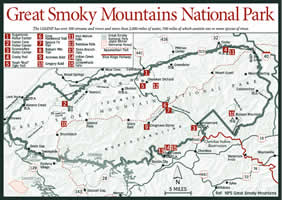

There are a great many waterfalls and cascades in the park, but the following are the most impressive and the most accessible. Three of these can be seen from roads: The Sinks and Meigs Falls are visible from the Little River Road between the Sugarlands Visitor Center and Townsend, and the Place of a Thousand Drips. The latter, located along the Roaring Fork Motor Trail is classified as a sometimes waterfall, with water flow varying dramatically between wet and dry weather periods.
[Fig. 45(11)] The hike to the falls is a pleasant walk through a poplar and hemlock forest and large rhododendron thickets. The waterfall is narrow at the top, but the water fans out as it drops.
[Fig. 44(6)] The falls is the highest in the park, and the trail to the cascade follows along the Middle Prong of the Little Pigeon River and Ramsay Prong, one of its tributaries. The trail initially follows an old road, but soon it begins to climb and cross streams along the way to a section of old-growth forest containing large yellow poplar, hemlocks, and black cherries. You're also likely to spot large specimens of silverbell and basswood, or linden as it's also called. The cascade is a 90-foot vertical plunge of whitewater down a series of rocky ledges.
[Fig.
45(12)] The trail to the falls passes along Le Conte Creek through
hardwood forests with beautiful displays of wildflowers, like pink turtlehead
(Chelone lyonii), in the spring and low-growing flowering shrubs including
trailing arbutus (Epigaea repens) and teaberry (Gaultheria procumbens).
Hikers will also see taller shrubs like pepper bush, or summer-sweet (Clethra
acuminata), a member of the white alder family. The waterfall drops straight
down for 80 feet, spraying a fine mist.

[Fig. 44(19)] The wide, packed dirt trail to this falls passes through a cool hemlock forest with large American beeches, maples, and silverbells and an understory of rosebay rhododendrons. The 30-foot Grotto Falls is formed by the cascading Roaring Fork, which has its headwaters near the summit of Mount Le Conte. Above the falls, the trail, also known as the Trillium Gap Trail, continues to Mount Le Conte. This route is taken by llamas used to carry food and linens to Le Conte Lodge twice weekly from late March to Thanksgiving.
[Fig. 44(7)] Mid-May is the best time to see the abundant laurel blossoms for which this falls is named. A paved trail to Laurel Falls leads through a pine-oak forest with an understory of flowering dogwoods and is wheelchair accessible, although steep in spots. Along the way to the falls, you may spot trailing arbutus flowering in early spring. The shiny leaves of galax are visible year-round. The trail crosses the 75-foot cascade on a wooden bridge. At this point, the paved trail ends and a steep, rocky trail climbs above the falls before continuing up the ridge.
[Fig. 44(9)] A large volume of water pours over this famous 20-foot falls into a broad plunge pool. The wide trail to it leads through rhododendron thickets and over a pine ridge as it travels along Abrams Creek past Arbutus Ridge.
[Fig. 45(13)] This falls is partially obscured by foliage during the summer months. It can be best seen during the late fall and winter months. It cascades about 60 feet into Deep Creek.
[Fig. 45(14)] The trail to the falls follows an old logging road paralleling Indian Creek and passes through a mixed forest with oaks, hemlocks, pines, and rhododendron on its way to a steep water slide.
[Fig. 45(15)] This is a lovely cascade that is reached on a trail that winds through a pine-oak forest lined with maiden-hair ferns and solomon's seal. There is a foot bridge across the 90-foot cascade.