 Savannah National Wildlife Refuge
Savannah National Wildlife Refuge
Savannah National Wildlife Refuge [Fig. 8, Fig. 5(1)] The Savannah National Wildlife Refuge, one of the best bird-watching spots in Georgia, is the single largest federally protected tract of land on the Georgia coast, stretching 20 miles along the Savannah River and consisting of 26,349 acres of freshwater marshes, tidal rivers and creeks, and bottomland habitat. (Cumberland Island is second with approximately 23,000 acres.) The refuge is one of the most important wildlife preserves on the East Coast, and during migratory periods is visited by 21 species of warblers and thousands of ducks of more than 13 species, including the rarely seen cinnamon teal, Eurasian widgeon, and fulvous whistling duck.
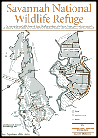
Located north of Savannah, the refuge straddles the Georgia-South Carolina state line where the Savannah River splits into separate channels and is fed by freshwater tributaries. As it flows south, the Savannah River splits into three forks below Interstate 95: the easternmost Back River, the centrally flowing Middle River, and the western Front River. The refuge includes the Middle and Back rivers, and the eastern bank of the Front River, which is maintained by Army Corps of Engineers dredging and used as a deep shipping channel for the Port of Savannah. Major travel arteries I-95 and GA 25/SC 170 cross the Savannah National Wildlife Refuge, which is also located across from a large industrial area on the western shore of the Front River.
Easily accessed by the outdoor enthusiast is the 6,000-acre southern portion located near US 17 in South Carolina. Here you find a 4-mile wildlife drive, nature trails, fishing, information, and bathrooms. Approximately 40 miles of intersecting dikes are open to hikers during daylight hours. (Automobiles are allowed only on the wildlife drive.) Biking on the dikes is permitted, but can be difficult if not impossible where the soil is very soft and sandy.
The northern portion of the refuge, known as Argent Swamp, makes up almost half of the refuge and is accessible only by boat. The 12,493-acre hardwood freshwater swamp tract was added in 1976, when The Nature Conservancy acquired a purchase option from Union Camp Corporation, then transferred it to the U.S. Fish and Wildlife Service which bought the land and added it to the Savannah National Wildlife Refuge. Argent Swamp straddles Georgia and South Carolina, and contains baldcypress and tupelo in wet areas and water oak, blackgum, red maple, sycamore, and sweetgum on drier, higher land. The freshwater impoundments attract over 13 species of waterfowl in winter while a variety of wading birds use this area throughout the year. During winter months, thousands of wood ducks are known to roost and forage in the bottomlands and bald eagles are frequently seen cruising over the swamp.
In Georgia, Native Americans built their settlements near rivers, a reliable source of food and water and important for transportation and trade. The area of the wildlife refuge, with navigable waters and abundant game, was no exception, and archeologists have found evidence of Paleo-Indian activity going back 7,000 years. Shell mounds provide evidence that the area was inhabited to various degrees between 5,000 and 1,000 years ago. Other clues reveal that Indians grew maize (or corn) 1,000 years ago in the Savannah National Wildlife Refuge. Unfortunately, like most parts of Georgia, extensive archeology work has yet to be conducted and probably won't be for a long, long time as experts believe most of the evidence is located under the rich muck of the freshwater pools and marsh that serve as sanctuary for many bird species.
In the late 1700s and early 1800s, American colonists believed the area was ideal for growing rice. Slaves and Irishmen cleared the mostly cypress and gum swamps that buffered the river during flooding. At least 13 rice plantations were constructed within the current boundary of the wildlife refuge. Colonists converted bottomland habitat into marshland by constructing impoundments, dikes, and trunks (water-control structures) to control the natural flow of fresh water from the river and tributaries. Across the river from the refuge was Nathanael Greene's Mulberry Grove plantation, where Eli Whitney invented the cotton gin and forever changed the history of the South. Trunks, or rectangular, wooden culverts with flap gates at both ends, were built from naturally decay-resistant cypress and installed under the dikes to control the flow of fresh water between the tidal river and the rice field impoundments. Rice plantations like these, dependent on backbreaking labor from slaves, flourished along freshwater tidal rivers from Georgetown, South Carolina to Brunswick, Georgia. The Civil War effectively ended Southern plantation culture, which struggled to survive after the war but collapsed without the benefit of slaves and with few economic resources to fall back on. The property was eventually purchased in 1927 and made into the Savannah National Wildlife Refuge, the oldest on the Georgia coast.
The well-engineered dikes, built by slaves and Irishmen, remain in place and today are used by U.S. Fish and Wildlife Service managers to benefit wildlife. Approximately 6,000 acres of former fields are maintained in 20 water-controlled impoundments to provide food and safe havens for wading birds during the year as well as migratory waterfowl that arrive during the winter. Because of the abundant avifauna, the refuge is popular with bird watchers, who have recorded 260 species at the refuge. The refuge is an example of man's interference with nature to benefit wildlife. If left alone, the former rice fields would convert to natural freshwater marsh and support smaller numbers of waterfowl and wading birds. Four major kinds of habitat make up the refuge: tidal freshwater marsh, freshwater pools and marsh; hardwood hammocks consisting of oaks and other species; and bottomland consisting of cypress and tupelo gum. Each has its natural complement of flora and fauna. Alligators are plentiful in the freshwater pools, including one whopper well over 12 feet long. More than 100 alligators have been counted in the diversion canal alone. In the spring, the bellowing of males will stop hikers in their tracks. The dike trails are great places to find signs of alligator crossings, with matted down marsh grass on either side and a connecting groove in the sand created by the crawling alligator's tail. It looks like he drew a line in front of your path daring you to cross it. During cooler months, the cold-blooded reptiles are seen on the banks of the canals bordered by dikes warming themselves in the sun. During summer months, they spend most of their time in the water, with just their eyes and noses protruding above the surface.
Also in the pools are abundant frogs and turtles, and snakes. Abundant but not commonly seen are the cottonmouth, brown water snake, banded water snake, mud snake, and rainbow snake. Frogs include the bullfrog, the bronze frog, and the green treefrog. Fish found here include bream, largemouth bass, crappie, gars, and bowfin. The refuge is an excellent place to look for butterflies and wildflowers.
If you love birds you will consider the wildlife refuge to be a natural treasure. Take a pair of binoculars and a bird book. The Savannah Coastal Refuges office has a free brochure that lists bird species found at the national wildlife refuges under its management. The brochure specifies the bird species that are found in the refuges, how common they are, what season they are usually seen, and whether or not they nest there.
Freshwater impoundments contain many plants such as millet, smartweed, and redroot, which are excellent foods for migratory waterfowl that visit the refuge during the winter months. Native plants include cattails, arrow-arum (Peltandra virginica), giant cutgrass (Zizaniopsis milacea), and golden club (Orontium aquaticum). A large, diverse group of bird species can be found nesting here. (A checklist is available from Refuge headquarters.)
Bird-watching is good all year but is best from October through April when temperatures are milder and a greater variety and abundance of waterfowl and other wintering birds are present. Be aware that from December 1 to February 28, entry into the impoundment areas Nos. 1 through 9 north of SC 170 is prohibited to reduce disturbance to wintering waterfowl.
The serenity of the natural scenery is visually disturbed by the ominous look of smokestacks rising from the nearby plants of Savannah's industrial sector. The implied threat has been realized on two fronts: first, unfortunate releases of toxic pollutants into the refuge and second, encroaching salt water from the dredging of the Front River for cargo ships.
Historically, intended and unintended releases of toxins into the Savannah River from nearby industries have polluted the refuge. Eight major industries are located directly opposite the refuge. Before the harmful effects were clearly understood, DDT and other chlorinated hydrocarbons and toxic chemicals worked their way into the food chain, interfering with the success rate of nesting birds. Local industries have periodically footed the bill for cleanups of asphalt and oil spills and other mishaps. Today, with stricter water quality standards, local industry is much more careful with its wastes, and the refuge's water quality is carefully monitored.
The refuge's natural communities are dependent on clean, fresh water. Left alone, the Savannah River is naturally 24 feet deep. But to create a more commercially competitive harbor that can allow new classes of even larger cargo ships to navigate the river, over the years the U.S. Army Corps of Engineers has had to dredge the river to even greater depths. Each year, the U.S. Army Corps of Engineers dredges out 7 million cubic yards of sediment. As this book goes to press, plans were being drawn up to increase the depth from 42 feet to 48 along 26 miles of the Savannah River. This will allow more seawater to back up the river, raising the salinity of the river water. If it gets too salty, fresh water-dependent aquatic flora and fauna of the refuge will die or move away.
To create a kind of "natural" dredge, the U.S. Army Corps of Engineers built a tidal gate to control the Savannah River. The tidal gate was installed on the Back River to block one channel of the Savannah River. This, in turn, was designed to force the river's flow to accelerate through the remaining open channel, which would naturally flush river sediment and thus reduce the expensive need to dredge. As part of the $2.5 million project, the U.S. Army Corps of Engineers decided to build a freshwater diversion canal to insure that the refuge was supplied enough fresh water. Unfortunately, salt water backed up farther than engineers thought it would, to where the southern intake point couldn't be used. The gate was abandoned in 1990, after almost completely wiping out the striped bass fishery of the Savannah River. With the tide gate now inactive, the refuge uses the diversion canal to distribute fresh water to its impoundment system and neighboring private plantations. This helps support the freshwater marsh and pools that the migratory waterfowl are so dependent on every winter.
[Fig. 8] This is the most popular and used portion of the Savannah Wildlife Refuge. Here you will see alligators sunning themselves on the banks, long-legged wading birds, deer, turtles, and possibly an otter or other shy creature. Aside from the brick cistern located on the cistern trail, visitors will see few historic artifacts from the area's plantation era. The drive follows a 4-mile route on top of dikes constructed in the late 1700s and early 1800s through four of the rice plantations that were located in the area. The Wildlife Drive has an appropriate surface for a mountain bike. Hikers may want to drive this route and hike on the quieter portions of the refuge.
The drive begins at the entrance to the refuge on the southern side of SC 170 east of the Savannah River. Here you find an exhibit shelter with a map and brochures detailing the drive, parking, and bathrooms. Near the entrance you will notice some beautiful, large Live Oaks that bordered the Laurel Hill Plantation home. The 400-acre rice plantation was purchased in 1813 by James Hasell Ancrum, who had 150 slaves quartered at a site now occupied by the refuge boathouse across the highway. The only structural remains of the plantation are a few bricks from the foundation of a steam-powered mill located near the site of the main house.
As you proceed on the drive, you will see the reclaimed rice fields and dikes that are now managed for wildlife and waterfowl. Worth examining are the rice field trunks that control the flow of water between the Little Back River and the 2,800-acre impoundment system. These simple mechanisms were vital to the economy of Georgia's coastal plantations. Traditionally, they were made of rot-resistant cypress, but today they are made of cheaper pressure-treated pine. As one brochure states, "in a tidal situation, a more efficient, economical water control device has not been found."
To flood the pools, the gate on the river side is raised while the inner gate remains down. As the tide rises, water flows through the culvert or "trunk" beneath the dike pushing open the inner gate. To maintain a constant water level in the freshwater pools, both gates are lowered and water cannot enter or escape. To drain the pools, the poolside gate is raised while the outer gate remains down. As the tide falls, water from the pool flows into the river, pushing open the outer gate. Flooding or draining cannot be completed during one high or low tide. But during the process, water flow is controlled because one gate remains down and closed by the pressure of water either in the pool or the river.
As the wildlife drive enters the historic property of the former Recess Plantation, you will encounter the cistern trail. Recess Plantation was bounded by Laurel Hill to the north and Moreland Plantation on the south. The cistern, a 7-foot-deep brick structure that collects rainwater, is the only remaining relic from the refuge's plantation past. A 300-foot-long trail leading from the cistern goes through a hardwood hammock, a good place to encounter migratory songbirds such as hermit thrushes, and white-throated and fox sparrows (winter). Not only do you find the usual hardwood hammock flora, but also found here are exotic Chinese parasol trees.
The drive goes by the 5.5-mile-long freshwater diversion canal, a popular site for fishing. Common catches include bream, crappie, and largemouth bass. Wading birds also join in the hunt for food.
As the wildlife drive turns back to SC 170, visitors will see many freshwater pools where alligators make their homes. Some of the pools are maintained at a depth to suit water birds such as wood ducks that nest in boxes supplied by the refuge managers. A lack of suitable nesting cavity sites in older trees (due to logging) in traditional wood duck habitat has spurred many waterfowl refuges to build and install these structures to help prop up populations of the beautiful wood ducks.
Because the northern end of the refuge is swamp, accessible only by boat, the best place for hiking or biking is a 3,000-acre section of the wildlife management area on the southern end of the refuge. Here, hikers can use 40 miles of dikes as a trail system. This is not one big looping trail, but a network of intersecting trails located just north and south of SC 170. The best approach is to use a map and select a section of dikes and head out early in the morning, when birds and wildlife are more active. Motorized traffic is prohibited on all these roadways except for the Laurel Hill Wildlife Drive. For a more peaceful, less crowded hike, choose impoundments Nos. 1 through 9 on the northern side of SC 170. Because these trails follow along freshwater pools, insects can be a tremendous nuisance if you are not protected. Binoculars and a bird identification book are highly recommended.
One route you may want to consider starts near the exit of Laurel Hill Wildlife Drive on the north side of SC 170. From here, walk 2 miles on the eastern side of the freshwater diversion canal. This will take you to the Tupelo Swamp Trail, which is the only opportunity in the refuge for hiking into swamp habitat. Prothonotary warblers nest near this trail. Vernezobre Creek acts as the northern boundary of this area and provides excellent habitat for wildlife.
Biking on the dike trails is a dicier affair. In some places, the path is too sandy for a mountain bike, and depending on the weather, the trail may be too soft and muddy. Where the trail is hard-packed enough, biking can be a great way to view the marsh. Scout the trail before committing to your plans.
Fishing is popular at the refuge. Fishermen catch everything from largemouth bass and bream to more primitive eels and gar. All refuge canals and pools are open to fishing from March 1 to November 30 and tidal creeks are open year round. Bank fishing from the wildlife drive is permitted all year. Kingfisher Pond, located off SC 170 one mile north of the junction of SC 170 and US 17 is also open to fishing year round. The refuge administers deer, feral hog, turkey, and squirrel hunts during the fall and winter. Since the refuge is divided by the states of Georgia and South Carolina, those wishing to hunt in the refuge should familiarize themselves with the area in which they wish to hunt and obtain the appropriate state licenses. Also, as in all wildlife refuges, permits are necessary and are obtained from the Savannah Coastal Refuges Office in Savannah.
A public boat ramp is found off GA 25 on the Savannah River adjacent to the Houlihan Bridge in Port Wentworth, Georgia. A historical marker across GA 25 from the ramp signifies the importance of GA 25, the oldest road in Georgia, which linked Savannah to Darien. It dates back to 1736 and was laid out with the assistance of General Oglethorpe's Indian friend Tomochichi, the mico of the Yamacraws.
Read and add comments about this page