| |
The Natural Georgia Series: The Chattahoochee River |
The Chattahoochee is a river under great pressure and stress. The headwaters of the Chattahoochee River above Atlanta comprise the smallest watershed, or drainage area, which provides a major portion of the water supply for any metropolitan area in the country. Not only do the 3 million plus people of Atlanta drink from it, but they also deposit their wastewater into it and use it as a playground. In addition to visiting the 4,000 acres of riverfront owned by the federal government and operated as the Chattahoochee River National Recreation Area, Atlantans escape to the headwaters region. They camp and hike along the banks and use the riverbanks as a trash can. They play at Lake Lanier, the most visited federal lake in the United States, which is home to about 13,000 homes, more than 23,000 boats and 7,500 private docks.
Residents, developers, landowners, and visitors in the headwaters region and metro Atlanta seem to forget sometimes that the Chattahoochee does not end shortly downstream. It flows southwesterly 436 miles to the Florida border, defining the state boundary between Georgia and Alabama along the way. At Lake Seminole on the Florida border, the Chattahoochee is joined by the Flint River and becomes the Apalachicola River, flowing 106 miles to Apalachicola Bay where it empties 16 billion gallons of fresh water per day. All of the trash, sediment, pollution, toxic chemicals, and heavy metals it picks up on this long journey affect users downstream, not to mention aquatic life.
River advocates say in order to solve the Chattahoochee's problems the public must understand that everything it does along the river affects something downstream. People responsible for wastewater and urban runoff in Atlanta, developers who allow sediment to run off steep construction sites in the north Georgia mountains, and southwest Georgia farmers irrigating their fields all have a responsibility to think about downstream neighbors.
The Chattahoochee is also a river of great hope and promise. Over the past year, the city of Atlanta was forced by a federal consent order to remove 568 tons of trash, including seven automobiles, from streams that feed into the Chattahoochee. Negotiations in the tri-state water war have not led to an agreement yet, but public awareness of the issues facing the Apalachicola-Chattahoochee-Flint river basin has been raised and conservation organizations have come together to fight for the river's flora and fauna, some of the most diverse in North America. One of the most exciting opportunities facing the Chattahoochee is the effort to establish a 180-mile riverway along its banks from Helen to Columbus.
This is a pivotal time in the history of the Chattahoochee and understanding the issues and opportunities facing this river is important to ensuring its future.
Early in its journey to the sea, the Chattahoochee River arrives in metro Atlanta where it faces a number of threats ranging from sewage, to urban runoff, to erosion and sedimentation.
While other Georgia cities drink water from and deposit treated wastewater into the Chattahoochee, none is growing faster or placing more stress on the river than Atlanta. In the 1990s, Atlanta gobbled up land at a faster rate than any other settlement in human history. Estimates released in December 1999 by the U.S. Census Bureau show that population in Atlanta's 20-county Metropolitan Statistical Area increased by 786,559 from 1990-1998. That means metro Atlanta was second only to Los Angeles in the number of new reseidents gained during that period. The Atlanta Regional Commission estimates that in 1997, the 10-county metro region grew by 79,000 new residents and predicts that by 2020, the population will increase by more than 1 million. All of these new people, plus the current population of 3 million plus, will have to start looking for a new water source by the year 2030: They will have outgrown the Chattahoochee and Lake Lanier says Bob Kerr, Georgia's chief negotiator in the interstate water war.
In the meantime, the Chattahoochee River supplies 70 percent of metro Atlanta's drinking water, which is more than 300 million gallons per day, and metro Atlanta's sewage treatment plants release more than 250 million gallons of treated wastewater per day into the river.
But Atlanta's antiquated sewer system has not been able to accommodate the city's growing number of water users. Cracked and leaky sewer pipes, as well as overburdened combined sewer overflows (CSOs), are contaminating the city's waterways and have cost Atlanta $19 million in penalties since 1990. All this pollution floats downstream from Atlanta killing stream life, limiting recreation, and raising the cost of treating river water to be used as drinking water.
In 1998, the city paid an additional $2.5 million, the largest one-time monetary penalty ever assessed under the federal Clean Water Act, as part of a federal consent order that also requires Atlanta to clean up the pollution from its CSOs and spend $27.5 million to clean up waterways and create a greenway corridor along the Chattahoochee. The federal consent order was part of the settlement of a 1995 lawsuit by the Upper Chattahoochee Riverkeeper and several cities and counties downstream of Atlanta.
Sally Bethea, the Upper Chattahoochee Riverkeeper, says, "The city of Atlanta did an excellent job in conducting its one-year clean up of 37 miles of urban tributary. In fact, they removed 568 tons of tires, scrap metal, and other debris from streams that lead into the Chattahoochee. Right now the city is working with its consultants in preparing a greenways acquisition master plan whereby the city is required to spend $25 million buying land primarily on tributaries to the Chattahoochee and South rivers."
While the Riverkeeper suit dealt exclusively with CSOs, in 1997 federal and state officials uncovered information that led to additional enforcement action against the city, this time dealing with the sewage collection system and sewage plants. Today, the city's entire sewage system is under a comprehensive federal consent decree. And while Atlanta did successfully complete the clean-up portion of its settlement with Riverkeeper, it has failed to live up to some of its other promises. As a result, in December 1999, the city of Atlanta faced another $2.8 million in federal fines for allegedly failing to meet deadlines and other terms of the federal consent orders.
While these problems are certainly expensive ones, with the pricetag for upgrading Atlanta's treatments plants, sewer lines, and CSOs expected to be as much as $2 billion over the next decade, there are other threats, including urban runoff from concrete, asphalt, and steel surfaces. Urban runoff is a type of nonpoint-source pollution, which is pollution that does not come from the end of pipe but instead from a nondiscrete source and includes runoff from construction activities, agriculture, and forestry. Urban runoff is the second highest national source of nonpoint-source pollution (only agricultural runoff rates higher), and it is a big problem in Atlanta.
According to No Fishing, No Swimming, No Drinking: America's Urban River Crisis published by American Rivers in 1995, Atlanta urban runoff delivered approximately three times as much oxygen-robbing organic matter, roughly the same amount of nitrogen, and roughly one-fifth as much phosphorous to rivers and streams as did its sewage plants. Runoff from nonconstruction related activities produced 25 times the amount of sediment as sewage plants. And the annual volume of oil and grease that runs off Atlanta's roads and streets is comparable to that of a major oil spill.
The largely impermeable ground surface of urban areas like Atlanta greatly alters the conditions of rivers that run through them. During rainstorms, stormwater that would normally filter through the ground or be stopped by vegetation is swept down city streets and into streams at an accelerated rate. This increases erosion rates and sedimentation of rivers and increases flooding. Not only the volume of urban runoff but also the pollutants and toxic materials it carries make it a destructive force to urban rivers like the Chattahoochee.
The runoff picks up bacteria, oil, grease, heavy metals, and trash as it rushes into the Chattahoochee. Once these substances reach the river, they can have a wide range of effects on the health of the ecosystem. Oil and grease from streets and parking lots attaches to sediment, is ingested by aquatic organisms, and becomes harmful to the entire food chain. Phosphorous and nitrogen from sources like golf courses, lawns, and parking lots can cause algal blooms and excessive aquatic weed growth, which rob other aquatic life of oxygen and sunlight and reduce fish and wildlife habitat. Runoff flowing over hot impervious surfaces can also increase the river's water temperature. Temperature changes can impact certain aquatic species, including trout and stoneflies, which can survive only in a narrow temperature range.
Even after filing suit against Atlanta over its wastewater problems, Bethea remains most concerned about urban runoff, stormwater pollution, and erosion and sedimentation caused by urban development: "The largest impact to the Chattahoochee River system comes from stormwater and eroded soil flooding into the river and its tributaries changing the hydrology, polluting the system, and becoming an increasing cost for downstream taxpayers. This is a system that 3 million people drink water out of, and we tend to forget that there is a significant treatment cost when dirt, mud, stormwater, and other pollutants flow off of our construction sites and off of shopping center parking lots and rooftops and into the river. It's the pollutants in that mix and it's also the volume and the velocity of the flow, which sweeps down through these streams and into the river, scours out the system, causes flooding downstream, and destroys habitat for critters."
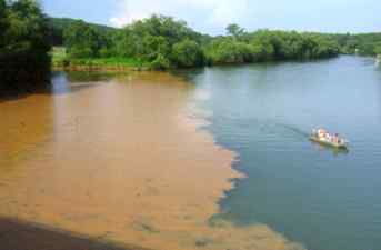
If you doubt that erosion and sedimentation are problems in the Chattahoochee, check out the color of the river and its feeder streams after it rains. Sediments turn the water a muddy brown and orange-red that most of us have gotten used to, but it is not natural and not healthy for the river. State and environmental protection officials as well as environmentalists admit that eroding soil is the most serious water quality problem facing Georgia today.
According to the U.S. Environmental Protection Agency, eroded sediments account for 80 percent of the pollution in the nation's streams. The costs of this environmental problem are staggering: Throughout the U.S. the annual costs of water-caused soil erosion are estimated to be about $7.4 billion and annual costs for all causes of soil erosion are estimated to be $44 billion, according to Aquatic Fauna in Peril: The Southeastern Perspective. And these estimates do not account for sedimentation's biological impacts and intangible impacts on humans.
Excessive sedimentation destroys aquatic habitats by reducing habitat complexity and diversity. Sediment eliminates habitat niches for macroinvertebrates, damages the gills of fish, and blocks sunlight from aquatic plants. Fish and other animals often lay their eggs in rocky stream bottoms, but mud from sediment robs them of their spawning ground. Metals, oils, toxins, and bacteria that enter waterways attached to sediment are also threats to aquatic systems.
Turbidity caused by sediments in the water is one of the most serious consequences of erosion. Not only does it reduce the amount of light and photosynthesis in a stream, but also it diminishes ight-dependent fishes' ability to detect prey and potential mates.
According to Chris Skelton, an aquatic zoologist for the Georgia Department of Natural Resources, Georgia Natural Heritage Program, the bluestripe shiner is an example of a Chattahoochee and Flint rivers fish that is especially susceptible to sedimentation. "When it spawns, the female shoots an egg as far as 1 inch into a crack in a rock or a piece of wood. Then the male swims along and fertilizes it. If there are no available cracks, the fish can't reproduce."
Human costs include not being able to raft, swim, and fish in certain areas of the Chattahoochee that have become clogged with sediment, making them unsafe for recreation. And sediment blocks water intake pipes and makes it necessary to spend more time and money dredging the river to rid it of sediment and adding chemicals to the water to treat it for human consumption. Soil particles also damage the turbine blades in hydropower plants and fill stream channels and lakebeds with sediment, which increases the frequency and severity of floods.
Soil erosion and sedimentation is a natural process, but it has been greatly accelerated by man's logging, farming, mining, and land development activities. As the mountains of north Georgia become an increasingly popular spot for second homes and commercial structures, the Chattahoochee is more threatened than ever by runoff. When developers clear steep sites of their vegetation, there is nothing left to hold the dirt and keep it from washing into the river and its feeder streams. This loss of topsoil not only causes water quality problems, but also it results in habitat degredation along stream and creek banks and riversides. On land, plants decompose and add organic matter to eroded rock, which concentrates nutrients in the top layer of soil, or topsoil. An abundance of rich soil means greater plant life and, in turn, more diverse animal communities. This valuable topsoil is washing away.
Along with the sediment, runoff from chicken, hog, and cattle farms washes into the river, raising the levels of fecal coliform bacteria. When it reaches Lake Lanier, the Chattahoochee dumps enough silt daily to cover 2,000 acres of land with 1 foot of dirt.
When the river arrives in Atlanta, it is in for more degradation. Land is being cleared and development is taking place at unprecedented rates. An average of 50 acres of tree cover is bulldozed in metro Atlanta and neighboring counties each day, and American Forests, a national conservation organization, has determined that since 1972, metro Atlanta has lost 60 percent of its natural tree cover. As land is cleared, not only do sediments rush into the Chattahoochee, but also the river's water temperatures rise because there is no shade along its banks. Billions of gallons of stormwater that once would have soaked in the ground or been absorbed by vegetation rushes into creeks and streams. As a result, the Chattahoochee River dumps tons of dirt into West Point Lake south of Atlanta.
More than 20 years ago, the Georgia legislature passed the state's Soil Erosion and Sedimentation Control Act, which is supposed to control this environmental problem. According to the law, the Georgia Environmental Protection Division (EPD) delegates enforcement to counties and cities, which issue land-clearing permits to developers. The permits outline general best management practices (BMPs)-such as the use of silt fences, hay bales, and sediment ponds-that builders are to use to control erosion. If the BMPs aren't followed, the work site can be shut down. But according to conservationists, a lack of enforcement, the lack of an objective standard to document whether erosion control measures are working, and shared regulatory responsibilities among numerous understaffed government agencies have made the law a disappointment.
Bethea, the Upper Chattahoochee Riverkeeper, says, "Stream buffer requirements, requirements to keep your soil on your site, and other water quality protective measures are all required somehow by state or local law, but the laws are cumbersome and convoluted and the development community has been ignoring the law. And there has been no enforcement. It is like putting up speed limit signs on streets and never having a cop out there: Eventually people figure it out."
One thing developers have figured out is how easy it is to get a variance, or permission, to violate stream buffer laws that make it illegal to dig up land within 25 feet of any stream. According to data compiled by the Georgia River Network, a private environmental group, during the last three years, the state EPD has approved at least 86 percent of 783 requests from developers to manipulate land within the buffers. While protecting stream buffers alone cannot save the river and water quality, environmentalists say the fact that variances have become the rule rather than the exception illustrates failures in enforcement.
Bethea says, "Vegetated stream buffers are only part of the solution, only one BMP, but they are the last line of defense between the creek and whatever land-disturbing activity is going on. We're not deluded by the thought that if you have green stream buffers along every creek and everything is going to be fine, but buffers do filter out pollutants, maintain habitat, cool the water, and decrease flooding downstream. The granting of variances is a perfect example of how state law has been basically ignored and unenforced."
Admittedly, cleaning up eroded sediment in the river will be difficult because it's not easy to control contamination that comes from so many varied sources. But groups like the Georgia Wildlife Federation will continue trying says President Jerry McCollum: "Protecting the river from erosion and sedimentation is an exceedingly difficult thing to do. Even with good regulations it's a difficult thing to police. That's why we need citizen activists to help government agencies monitor water quality. That's an important role of conservation organizations in the state and GWF members who live along the river."
Since 1992, the states of Georgia, Alabama, and Florida have been waging a war over how to best allocate the states' shared water resources. Negotiations have taken place over how to allocate water in two river basins: the Chattahoochee-Flint-Apalachicola (ACF) and the Alabama-Coosa-Tallapoosa (ACT). After failing to meet a December 31, 1998 deadline, negotiations were extended and a new deadline of December 31, 1999 was set.
Negotiators missed the new deadline and have now agreed to extend the deadline until May 1, 2000. The first 60 days will be used to develop an allocation formula and the second 60 days will be for public comment and review. If negotiators fail to meet the deadline and talks between the states end, the battle over water will likely end up in the U.S. Supreme Court.
All three states have a great deal at stake in this war. They all agree that water availability is important to future economic growth. As Georgia (particularly Atlanta and north Georgia) continues to grow and withdraw more water out of the Chattahoochee River, Alabama and Florida are concerned there won't be enough water flowing downstream to meet their biological and human needs. Alabama wants enough water in the ACF and ACT to meet its own projected growth needs. Florida wants to make sure it will receive enough water from Georgia to protect the vital seafood harvesting industry and the marine life in Apalachicola Bay.
Failing to negotiate an agreement and winding up in court will most likely be a time consuming and costly alternative for all three players. Officials, including Georgia's two senators and eight of its congressmen, have warned that litigation could take more than 10 years and be devastating to the Georgia economy. U.S. Representative Bob Barr has warned the court could issue a moratorium on new water withdrawals, which would cost the state billions of dollars and bring development to a screeching halt.
Some Georgia officials have said Georgia would do well if the issue winds up in court because neighboring states would have a hard time proving Georgia's increased water demands would harm them. Georgia's chief negotiator Bob Kerr says, "We're the upstream state and we have a right to the reasonable use of waters that flow in our state."
But Matt Kales, program manager for river basin protection for the Upper Chattahoochee Riverkeeper, says he and his organization's attorneys disagree, "If Georgia thinks it comes from a position of strength in court because the water starts here, they are sorely mistaken. Florida and Alabama have just as much right to that water because it flows downstream."
The stakeholders in this fight are numerous and varied. Barge operators on the lower ACF want to make sure there will be enough water for boat traffic, hydropower producers say Georgians could pay higher electricity rates if power production is reduced to provide more water for drinking and industrial use, and downstream municipalities like Columbus want enough water to grow. Anglers and paddlers are looking for water in the right places to enjoy recreation in the river basin, and southwest Georgia farmers could face limits on how much groundwater they can use to irrigate crops. (When farmers pull water out of the Floridan Aquifer, springs that flow from that same aquifer drop down and do not feed as much water into the Flint River.)
Kerr says, "We're fully aware, fully concerned, and fully dedicated to making sure we don't dry up the rivers and we don't kill the species, but we're also committed to being sure we have allocated to the state of Georgia a reasonable amount of water."
One of the stumbling blocks in the way of an agreement is Georgia's promise that the water flowing from the Chattahoochee and Flint rivers into Florida will never drop below a certain "minimum flow" at the Florida-Georgia state line, even during times of severe drought. Florida officials aren't sure the minimum is enough and neither is the conservation community. Some environmentalists are concerned that the minimum will become a flow target instead of a worst case scenario flow-that the state will withdraw enough water that the minimum flow becomes standard.
Kales says, "That minimum flow number is based on the lowest flow ever recorded, and we don't think that's what you should shoot for. The state says it's not a target that Georgia can't hold that much water back because there is no where to store it, but we don't believe them. They can build small reservoirs or remove the water from the stream."
Kerr says, "When we talk about minimum flows, we're not talking about targets. These are worse case scenario minimums that would occur during periods of drought. Most of the time, there will be flows very comparable to what you see today-a full range of flows. There is no way the state of Georgia can hold the water back."
Lindsay Thomas who represents federal agencies at the negotiating table and would have to concur with an agreement reached, says he is doubtful an agreement based solely on minimum flows would receive federal approval. "We also need reservoir management plans and drought management plans," Thomas says. "If the agreement is based solely on minimum flow, it will be difficult for federal agencies to do evaluative work."
The federal agencies Thomas represents will evaluate an allocation formula the states agree on to be sure it does not violate any federal laws such as the Clean Water Act or Endangered Species Act.
Some of the most important stakeholders in the water war are the plants and animals that live in the Apalachicola-Chattahoochee-Flint river basin. The ACF basin is among the most biodiverse temperate freshwater ecosystems in North America. It is home to 30 species of native crayfish, the largest diversity of fish fauna among the Gulf Coast river drainages east of the Mississippi River, 16 species of freshwater aquatic turtles, 21 species of salamanders, 26 species of frogs, and the American alligator. "The basin is a treasure trove of biodiversity," says Kales.
Members of Tri-State Conservation Coalition, formed by the Upper Chattahoochee Riverkeeper and made up of nongovernmental conservation organizations including the Georgia Wildlife Federation, believe that one of the keys to maintaining biological diversity in the ACF basin in maintaining a natural flow regime. The natural flow regime is the conditions, the water highs and lows, that would exist in a stream without any human interference. Conservationists believe that ensuring natural flow regimes will be maintained in the basin is more important than assuring some level of minimum flow at the Georgia state line.
Jerry Ziewitz, a fish and wildlife biologist for the U.S. Fish and Wildlife Service, agrees that a cycle of high and low flows is important: "Over the course of time, all animals in and near the river have adapted to patterns in change of flow, and for some species, their biology is essentially tied to those flows. We have incredibly diverse fauna in the ACF basin in part because we have such a dynamic flow regime, which creates a diversity of habitats. There are 160 species of fish in the basin, compared to large western basins that only have 20 species of fish."
When rivers overflow their banks into the floodplain, many fish species use the river's extensive swamps and side channels for spawning and feeding grounds. The duration of these highs and lows is important, too. If the river recedes too rapidly, fish may be stranded in the floodplain. If dry periods aren't long enough, baldcypresses can't germinate.
Chris Skelton of the Georgia Natural Heritage Program explains that freshwater mussels are another example of wildlife dependent on flow variability: "Some male mussels put their sperm in the water column and females downstream take it in so they have to have flows to reproduce. With other mussel species, the female lets out a lure, and if there is no flow to make fish come by that lure, her reproductive year is lost."
The Nature Conservancy, the national organization, is working hard to provide the science that the conservation community is standing on as it tries to influence the water war negotiations. Ruth Mathews, Apalachicola project manager for The Nature Conservancy, says an allocation formula should be based less on minimum flow requirements and more on human demands: "Maintaining minimum flow is a small piece of aquatic conservation and protecting biodiversity in rivers. To develop the allocation formula, we suggest identifying human demands (not minimum instream flow) and then designing reservoir operations accordingly. If you do so, you can come up with a fairly natural looking flow regime."
Kales says Georgia negotiators have rejected The Nature Conservancy's science, and Mathews says Florida has been the only real leader in recognizing the value in using reservoirs to mimic natural flow regimes. But, she says, The Nature Conservancy is pleased that all three states have recognized the need for at least some variability in flows. "In that sense, the biological case has been made in the region," she says.
As the three states work to balance human and economic needs, it is clear that biodiversity hangs in the balance. Now that the parties have missed another deadline, it is also clear the water war will continue. Whether it is around the negotiating table or in the courtroom, stakeholders agree they will keep fighting over precious natural resources in the Southeast, one of the fastest growing regions in the country.
With so many threats facing the Chattahoochee River, it is comforting to know there are ongoing effort to help keep it healthy. One of the newest and most ambitious efforts involves establishing a 180-mile greenway along the Chattahoochee from Helen to Columbus. It would be the longest river park in the country and consist of at least 500 feet of parkland on both sides of the river.
The riverway initiative is sponsored by the Trust for Public Land (TPL) and The Nature Conservancy of Georgia (the Georgia chapter of the national organization that buys land to protect plants and animals. It should not be confused with the Georgia Conservancy, an environmental advocacy and education organization.) These two organizations work in partnership with other environmental groups, cities and counties, government agencies and officials, businessmen, and private citizens. According to Rand Wentworth, director of the TPL Atlanta Field Office, it is the largest conservation effort in Georgia and one of the largest in the U.S. to date. The goals of the Chattahoochee Riverway are to assure safe, clean drinking water; enhance quality of life in communities along the river; protect an oasis of natural habitat in the midst of a rapidly developing region; and provide places for people to enjoy the river in their daily lives.
While work on the riverway will take place for decades, Wentworth says conservationists hope to have acquired most of the priority tracts in four years. So far, TPL has completed over 50 land acquisitions and secured 34 miles of river frontage. When you add that to land government agencies already own, 140 miles of land along the Chattahoochee are protected (there are 360 miles of riverway to be preserved when you count both sides of the 180-mile corridor).
With development rampant in the river corridor, the coalition working on the riverway feels now is the time to act to save land along the Chattahoochee. According to TPL, within three years development will cover virtually all river land between Lake Lanier and Atlanta and land between Buford Dam and Roswell will be completely developed by the year 2001. Below Atlanta, development has come more slowly, mainly because of pollution entering the Chattahoochee in and around the city. But as Atlanta is pushed to solve its wastewater treatment problems, less pollution will flow downstream and the value of land and amount of development will increase.
While each section of the river is critical, some of the most pressing areas are north of metro Atlanta where the river winds through heavily populated Forsyth, Gwinnett, Cobb, and Fulton counties and development pressure is high. The Nature Conservancy has also conducted a Rapid Ecological Assessment to give TPL and others a scientific basis for prioritizing ecological areas for preservation.
Through the Rapid Ecological Assessment, The Nature Conservancy identified 26 rare animals living in the watershed and discovered new locations of two federally endangered species: fringed-campion and relict trillium. But Stacy Patton, project manager for The Nature Conservancy says they were looking for more than threatened species. They are taking a "systems approach" and were looking for communities that could be restored or maintained.
Patton says, "At The Nature Conservancy we've taken an eco-regional approach and looked at river systems. We need the land and the water to make a difference to plants and animals, and we need enough land to give a buffer from nearby threats. We generally look at larger tracts of land so we can get that buffer and give wildlife a whole forest instead of just a few trees."
The Nature Conservancy and TPL are also working with Chattahoochee neighbors, including developers, to establish partnerships and conserve land not only through land acquisition but also through easements. But land that is not donated or granted a conservation easement must be bought, and buying land alongside the river, especially where development pressure is high, is expensive. On some parts of the Chattahoochee, river frontage costs $1 million per mile, according to state figures.
Money to preserve the land will come from federal, state, and private sources. Governor Roy Barnes has promised to help get state funds for the project but has not said how much. Federal funds have already been secured to increase the size of the Chattahoochee River National Recreation area in metro Atlanta. Bills have now passed the U.S. House and Senate to expand the boundaries from the current 6,800 acres to as much as 10,000 acres. The legislation also authorizes $35 million for the National Park Service and conservation groups to use to buy land that would create a 48-mile greenway within 2,000 feet of the river on either side of the recreation area.
Roy Richards, president and CEO of Southwire Company, serves as chair of TPL's capital campaign committee, which has raised over $100 million in private and public funds for the effort so far. Wentworth says TPL estimates protecting most of the endangered and available lands along the river will cost about $180 million.
Richards says this project offers Georgia a unique opportunity to do the right thing and counteract some of the negative results of Atlanta's abuse of the Chattahoochee. "I like this project because it's big, and it's good, and it lasts forever. Not often do you get a chance to work on a project that has all those qualities," Richards says. "I think the quality of life we have created in Atlanta will be poor unless augmented by a natural green space component. And Atlanta's laissez-faire, helter-skelter, free-for-all style of land development that we are today suffering from requires us to protect these green spaces as offsets to this sprawl we've created."
Jerry McCollum says, "Roy Richards's dedication to the river is lifelong, but his chairing of this campaign is a tremendous conservation achievement. I don't think it would have come together without him."
Establishing a buffer of land along the Chattahoochee would provide a place from the Blue Ridge mountains to the Alabama state line for Georgians to hike, bike, or just sit along the river. State leaders say it also makes economic sense to save green space because it is a symbol of quality of life, which contributes to economic growth. The Chattahoochee Riverway does have a cost, but those working on it are counting on people at the local, state, and federal level to recognize the Chattahoochee as a good investment.
 Focusing
on Solutions
Focusing
on Solutions Establishing the Chattahoochee Riverway is only part of protecting the health of the river's ecosystem and the quality of the drinking water that comes from it. No one believes it will solve all of the Chattahoochee's problems, but conservationists say it is a step in the right direction.
Sally Bethea says, "We've got to raise awareness that solving the problem is not just buying land along the main stem of a river but it is applying major first aid and visionary planning and thinking within the entire watershed. Buying up a 500-foot swath along the main stem of the river is only a part of the solution."
She says the city of Atlanta is on a path to solving its wastewater problems, but we all still need to look for ways to control erosion and sedimentation. "The solution is a watershed focus, public awareness, enforcing current laws, and getting clearer laws. The technical world needs to and is beginning to make a concerted effort to be creative and change business 'as we've always done it' to alternative ways that don't assume that streams in an urban area are just there to be drainage canals to carry off waste."
Another part of the solution is recognizing the seriousness of water quality issues and their potential impacts. While Governor Barnes and the media have given lots of attention to air quality problems and a lack of green space, water may be the biggest environmental problem facing Georgia early in the twenty-first century. A panel put together recently by Georgia Public Television predicted metro Atlanta will face a future water crisis that will make its struggles with air quality seem easy. As the water war is bound to continue, the Southeast will be faced with increasingly difficult conflicts over water uses and demands.
The Chattahoochee is certainly not Georgia's only river but the issues and opportunities it faces impact the entire state. Protecting the river and managing its resources wisely may be important keys to Georgia's future growth and prosperity, and lessons learned along the Chattahoochee can be applied to preserve the state's other precious river resources.
Read and add comments about this page
Go back to previous page. Go to Chattahoochee River contents page. Go to Sherpa Guides home.
[ Previous Topic | Next Topic ]