 Kings
Canyon National Park Kings
Canyon National Park
Kings
Canyon National Park Kings
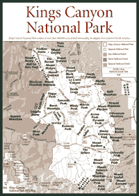
Canyon National Park [Fig. 52] Kings Canyon National Park offers some of the wildest and untouched natural views in the Southern Sierra. The park consists of more than 400,000 acres of land surrounding the deepest river canyon in North America. The Kings River canyon drops 8,200 feet from high in the Sierra to the San Joaquin Valley. It is deeper than Hell's Canyon on the Snake River in Idaho and the Grand Canyon in Arizona. With a canyon that drops more than 1.5 miles, it may not be surprising to learn that visitors come to Kings Canyon for the views.
The canyon developed its depth over the past 5 million years as the Sierra batholith uplifted and the Kings River eroded down into the granite. The combination of lifting up and eroding down resulted in the steep canyon. Wind, water, and geologic rumblings continue causing erosion. It also occurs through avalanches that promote large rock falls. Chutes or slides have developed over many centuries in the highest places on the eastern side of the park.
People have known about the inspiring sights of Kings Canyon for the last century. The park was established in 1940, decades after John Muir and the Sierra Club began a campaign to move it into National Park Service protection. Muir reacted to the widespread logging that took place in the 1890s in the giant sequoia groves of the area.
Visitors can see these logged areas by following trails in the area. Perhaps the most interesting view is of the meadow left by clear-cutting in Converse Basin. The basin extends more than 4,500 acres, and huge stumps of downed sequoias are found throughout the area. Unfortunately, there are a lot of places around Kings Canyon National Park where visitors can find stumps left behind by logging in the late nineteenth and early twentieth centuries.
But there are still many magnificent specimens remaining. The General Grant Tree, for instance, is the Nation's Christmas Tree. At about 6,500 feet in elevation, it is found at Grant Grove, just beyond the Big Stump Entrance Station on Highway 180 at the western tip of the park. This 2,000-year-old tree stands 267 feet high, and in December it towers above the snow as the annual celebration of the Nation's Christmas Tree takes place at its base. The tree was discovered in 1862 and named for Ulysses S. Grant. Grant Grove was its own national park in 1890. It was a little more than 2,000 acres, and it was added to Kings Canyon in 1940.
Prior to the arrival of European settlers, the Wobonuch tribe of Native Americans lived just west of Grant Grove. The Wobonuch, like the Waksachi, were part of the Monache tribe that crossed the Sierra crest from the Eastern Sierra about five centuries ago. Grant Grove was a summer gathering place for the Wobonuch.
The Redwood Mountain Grove, not far from Grant Grove, is one of the few places left on earth where visitors can find more than 2,000 giant sequoias in one place. Visitors can also see the red or creek dogwood (Cornus sericea) along Redwood Creek.
Cedar Grove is where Kings Canyon views can be found. Highway 180 or Kings Canyon Highway winds down the canyon into Cedar Grove, which has campgrounds along the river. Cedar Grove is the starting point for many hikes, including backcountry treks. From this area, backpackers can walk to some of the most pristine areas found anywhere in the Sierra. Many backpackers depart from Cedar Grove to hook up with John Muir Trail at the crest and walk all the way to Mount Whitney.
But Cedar Grove is a well-known haunt for black bears, which grow to 300 or 400 pounds eating the fatty scraps and leftovers they find in the garbage. Like black bears in Yosemite National Park, these creatures learn quickly and persistently pursue food. Bears have been known to rip car doors off to get at a piece of candy. Some bears must be destroyed if they become too aggressive.
Bears in the backcountry have not learned as much about human food as those in partially developed areas such as Cedar Grove. But backpackers must still place their food in bags and carefully hang the bags from tree limbs to keep the food away from bears or other animals. If the food is hung high above the ground and far enough away from the trunk of the tree, many animals cannot reach it. The lodgepole chipmunk (Eutamias specious) and the yellow-bellied marmot (Marmota flaviventris) are also known to take food whenever possible.
Marmots can be seen on some of the high Sierra trails in the backcountry of Kings Canyon. In the granite rising above beautiful Rae Lakes on the eastern side of Kings Canyon, marmots munch Sierra saxifrage (Saxifraga aprica) and alpine goldenrod (Solidago multiradiata) until their bellies are full. Then they bask in the afternoon sunshine.
The eastern part of Kings Canyon remains primitive and relatively untouched compared to the western part. The eastern side has no paved entrance. From the east, the only way to enter is on a trail through passes, such as Kearsarge Pass at 11,823 feet. But the eastern part of the park contains the John Muir Trail, one of the busiest high Sierra walking routes and one of the best-known high-elevation trails in the world. While it may look pretty remote on the map, there are many people walking this trail.
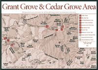 Cedar
Grove
Cedar
Grove [Fig. 53(1)] Backpackers and campers can find the wild Kings River and some of the most beautiful hiking trails in the Southern Sierra at Cedar Grove. Trails radiate in many directions to the backcountry, and from the campgrounds visitors can hear the river thundering in May and June as the snowmelt swells the Kings.
For hikers, it is usually best to start early in the day anywhere in the Sierra, but early is definitely much better at Cedar Grove. At about 4,600 feet in elevation—a mere 600 feet higher than Yosemite Valley—it gets warm in the afternoon at Cedar Grove. But the elevation also provides better weather earlier in the year for hiking. Some of the hikes can be steep and treacherous, so take care.
This is an area once considered for a highway through to the Eastern Sierra. But the plan was dropped in 1965, and the high Sierra beyond Cedar Grove remains free of paved roads, unlike the Northern and Central Sierra.
Cedar Grove also was considered as a place to dam the Kings River and create a reservoir, much as the city of San Francisco did at Hetch Hetchy Valley in Yosemite National Park. Los Angeles made the pitch early in the twentieth century, but Central Californians fought and delayed the effort long enough for supporters to run out of momentum.
In the meadows at the higher elevations around Cedar Grove, look for several kinds of grasses, including tufted hairgrass (Deschampsia cespitosa) and spiked trisetum (Trisetum spicatum). Visitors also will find black sedge (Carex nigricans) and beaked sedge (Carex rostrata), which are common in this part of the Sierra.
[Fig. 53(2)] Hikers who want to get a good look at Kings Canyon without pushing themselves too hard should consider the Mist Falls Trail. Many trails around this area gain elevation so quickly that it's just too much work to enjoy the view. This trail gains about 600 feet in elevation in full view of the South Fork Kings River as it tumbles and blasts through the rocks along this gorge.
In various places along this trail, hikers will see interesting combinations of chaparral in the driest areas and some sparse Jeffrey pine and lodgepole pine. In the chaparral community, look for the flower ash (Fraxinus dipetala), birchleaf mountain mahogany (Cercocarpus betuloides), and chaparral honeysuckle (Lonicera interrupta). They are a few of the many species living close together in these plant communities.
Glacially carved features are easy to spot along the trail. A granite spire called The Sphinx can be seen to the east of the trail. Glaciers polished the granite in many places, leaving it smooth and sometimes slippery when wet. Do not climb around the rocks near the river because they are slippery and you could fall into the river.
The nicest thing about the Mist Falls Trail is that hikers can stop in many places for a picnic lunch and simply turn around if they are tired. The views are grand throughout the hike.
[Fig. 53(3)] Stop here with the children for a quiet, easy stroll through nature. Visitors can see where Native Americans lived and created mortar holes into the granite as they ground acorns into a meal. The area is between the parking lot and the river where visitors might see mule deer (Odocoileus hemionus) browsing.
The acorns in this area come from the black oak (Quercus kelloggii), a common tree here. Hikers also can find California hazelnut (Corylus californica) and thimbleberry (Rubus parviflorus). The views include North Dome at 8,700 feet to the north.
The meadow is named after Daniel Zumwalt, a Tulare County lawyer who was instrumental in getting Congress to designate Sequoia and Kings Canyon as national parks. Zumwalt once owned the meadow.
[Fig. 53(4)] The Cedar Grove Overlook is where hikers go to see for miles all the way to the Great Western Divide to the east. From the overlook, people can look down the U shape of Kings Canyon.
But there's a price for this breath-taking view. You have to climb 1,400 feet to the top of the canyon. Carry a lot of water and start hiking early in the day.
The route to the overlook is called the Hotel Creek Trail. It was named for a camp that was established in the 1890s. Native Americans also used this area and the trail. They ate acorns from the black oak and the interior live oak (Quercus wislizenii).
The live oak is easily distinguished from black oak because it is evergreen. Various year-round bird residents favor this tree for the insects that it attracts. Look for the Hutton's vireo (Vireo huttoni), which nests in these trees.
[Fig. 53] The third largest tree in the world—the 267-foot-tall General Grant—can be found at Grant Grove, where short loop trails allow visitors to tour both living and felled giant sequoia. For people in a hurry, Grant Grove is the easiest place to see in a short amount of time.
Congress first set this area aside in 1890 as the General Grant National Park. In all, Congress preserved about 2,400 acres along a historic migration route for Native Americans in the area. Fifty years after Congress established it, the little park was absorbed into Kings Canyon National Park.
On the map, it still looks like an addition or appendage to the Sequoia-Kings Canyon National Parks. Grant Grove is at the western end of Sequoia-Kings Canyon along Highway 180, near the Big Stump Entrance Station where visitors choose either the Kings Canyon Highway to the left for Kings Canyon or the Generals Highway to the right for Sequoia National Park.
The height of the General Grant tree is impressive, but it is not among the tallest trees in the world. Its circumference is 107 feet, its volume of wood is estimated to be more than 47,000 cubic feet, and it probably weighs more than 2 million pounds. At more than 1,800 years old, the General Grant was growing a full millennium before Christ was born.
Along with the giant sequoia, the wild or western azalea (Rhododendron occidentalis) is particularly abundant and attractive at Grant Grove. It is found mostly in moist places below 7,500 feet. Grant Grove is at about 6,600 feet.
Within Grant Grove is a private community called Wilsonia. Such private communities inside national parks are not rare. Near Yosemite National Park, Yosemite West is a similar private community in the midst of public lands where development is restricted.
[Fig. 53(5)] A lot of people take this short loop trail because there is so much to see, and it is an easy jaunt for children. Often, children have fun playing around the Fallen Monarch, a giant sequoia that fell more than a century ago and has been hollowed out by fire. The fallen giant provided shelter for horses during storms when the park was first established in the 1890s.
The General Grant Tree is not much farther along the path. The tree, discovered in 1862 by Joseph Thomas, became the Nation's Christmas Tree in 1926. An annual event takes place on the second Sunday in December around the base of the tree to mark the holiday.
Other features along the trail include the massive Centennial Stump and Gamlin Cabin, which was one of the first ranger stations in General Grant National Park. Homesteader Israel Gamlin built the cabin in the 1870s. The Centennial Stump was part of a sequoia that was taken down in the 1870s.
[Fig. 53(6)] The sights at Big Stump illustrate the history of logging among the giant sequoia in this part of the Sierra. Early in the 1880s, almost an entire grove of the giants had disappeared. The names of some trees and stumps speak for themselves: Shattered Tree, Burnt Monarch, Sawed Tree, and the Mark Twain Stump.
The Twain Stump is interesting because it was cut down after General Grant National Park was formed in 1890. Apparently the Twain tree was just outside the old boundary, which was updated 75 years later to include the stump in the protection of the park. A slice or cross-section of the tree was shipped to New York for display in the American Museum of Natural History.
One living specimen teaches an interesting lesson about the giant sequoia. A lightning strike took off the top 20 or 25 feet of the Resurrection Tree many years ago. The resilient tree appears to be growing a new top.
[Fig. 53(7)] Along this trail, hikers are likely to encounter herbaceous species such as Hartweg's ginger (Asarum hartwegii), bride's bonnet (Clintonia uniflora), and rattlesnake orchid (Goodyera oblogifolia). The flora—including mountain dogwood (Cornus nuttalli)—is not found above about 7,000 feet in the Sierra. So, aside from the giant sequoia, the other vegetation makes this trail an attraction for many people.
Hikers will see a waterfall along Sequoia Creek, called Ella Falls. The banks and meadows around the creek contain white alder (Alnus rhombifolia) and arroyo willow (Salix lasiolepis).
The hike also allows visitors to see Sequoia Lake from a distance. The lake was created in the late 1880s when Sequoia Creek was dammed. Lumber companies used the lake as part of their flume operations, which sent logs down to the San Joaquin Valley.
[Fig. 53] Visitors can find the sixth largest grove of giant sequoia in the world at Redwood Mountain. It was logged briefly in the late nineteenth century, but more than 2,000 giants remain at Redwood Mountain and several trails offer hikers spectacular views of the trees. Among the giants are sugar pines (Pinus lambertiana), which can grow to 200 feet tall and 5 or 6 feet in diameter at the base, but visitors will have little trouble distinguishing between these two types of trees.
The giants thrive in white fir forests, which receive 40 to 60 inches of precipitation per year. But the giants must have moist soil even during the summer months, and the ones that receive adequate moisture throughout the year will grow the largest.
One of the more curious sights in Redwood Canyon is Redwood Log Cabin. It truly is a "log" cabin—a cabin made from one very large, hollow sequoia log. Park officials believe it was built by a tungsten miner in the late 1800s. The miner apparently placed boards over holes in the floor and built stone fireplaces at each end. The cabin can be seen along Redwood Canyon Trail.
The federal government bought the Redwood Mountain area in 1940 after mining and logging had ended. It was included in Kings Canyon National Park by presidential order. Today the Redwood Mountain area is probably the least noticed among visitors, but it has much natural history to offer.
[Fig. 53(8)] Aside from the Redwood Log Cabin about 5 miles from the trailhead, the giant sequoia and the gorgeous views are the main reasons to hike this trail. Redwood Mountain, a 7,001-foot granite peak to the west, is framed perfectly for photographing between the giants along the first 2 miles of the hike. To the east, hikers will see 7,605-foot Buena Vista Peak.
Many hikers with children choose to just walk about 2.5 miles to the Redwood Creek crossing and turn around. The trail runs along the creek for almost 2 miles, showing off greenish-yellow blossoms on the California dogwood (Cornus nuttallii). In May, the blossoms are particularly beautiful. By early autumn, the trees' pink and reddish leaves light up the forest.
The migratory birds in this and other areas along the Redwood Canyon Trail are richly diverse. Look for the yellow warbler (Dendroica petechia), the MacGillivray's warbler (Oporornis tolmiei), and the Swainson's thrush (Catharus ustulatus).
The giants include the Hart Tree and Fallen Goliath. The Hart tree was named for William Hart, who owned a sawmill and almost 100 acres in this area during the 1880s. But there are hundreds of unnamed sequoias, many with diameters larger than 10 feet. In the surrounding forest, there are incense cedars and white firs.
At one point near the end of the trail, which concludes at Big Springs, hikers will see a sign warning them to stay away from a research area where scientists want to study the ecosystem without human disturbance. The area is one of several places where researchers studied the effects of fire on sequoia ecosystems in the 1960s and 1970s.
Like most trees in the Sierra, the sequoia periodically needs a fairly hot fire to burn out the underbrush and give the trees room to grow and reproduce. For many decades in the twentieth century, federal officials snuffed fires at the first sign of smoke. The result was a lot of brush growth and the potential for very large fires that would reach the canopies of large trees and destroy groves of older trees. Federal officials now incorporate fire into forest management, allowing some blazes to burn.
Read and add comments about this page