 Shenandoah
National Park & Skyline Drive Shenandoah
National Park & Skyline Drive
Shenandoah
National Park & Skyline Drive Shenandoah
National Park & Skyline Drive [Fig. 43, Fig. 44] When President Franklin D. Roosevelt dedicated Shenandoah National Park in 1936, a novel experiment in public land use was begun. At the time, most national parks were being set aside to protect already-existing natural beauty, wildlife, and wilderness. Shenandoah National Park was an attempt to determine if 196,466 acres of damaged mountain land would revert to a pristine state if set aside and protected from further human alteration.
The land-use experiment would run counter to the traditional precept that land was to be used in ways most beneficial to man and that nature and wilderness were little more than impediments to be conquered. Long, narrow Shenandoah National Park—100 miles in length and ranging from 13.2 miles to less than 1 mile in width—was formed from mountain land that had been the subject of hard human use since the first settlers began trickling into the area in the early to mid-1700s.
By the beginning of the twentieth century, farmers had established agriculture, orchards, and grazing land. Loggers increased the cutting of the mighty oaks and chestnuts and dragged them off the mountains. Sheep and cattle grazed where bear, elk, and wolves once roamed. The thin soil was wearing out along the crest of the Blue Ridge range where Shenandoah National Park was to be located.
Weary of the hard scrabble life in the mountains, people were beginning to move out. More than half the residents had left by the mid-1920s. The rest sold their land for establishment of the park, or they were relocated with federal assistance.
Not everyone was ready to leave the mountains. The people whose farms and homesteads were condemned fought the legal seizure by the Commonwealth of Virginia for a dozen years. Though the federal government permitted a few residents to live in their homes for the remainder of their lives, among the descendants of the mountain families, resentment still simmers in little towns such as Elkton, Luray, Sperryville, and Stanardsville in the Shenandoah Valley and Piedmont Virginia.
Land acquisition for the park would take years. But a 100-foot right-of-way for the Skyline Drive was acquired quicker through gifts and special purchases. The highway along the ridge was planned as the park's outstanding feature. President Herbert Hoover, who had a vacation cabin on the nearby Rapidan River, urged the approval of funding for road construction. Local crews began work in 1931, and on August 29, 1939, Skyline Drive [Fig. 44] was opened.
Meanwhile, President Roosevelt had taken office in 1932 and immediately established the Civilian Conservation Corps (CCC). Almost 1,000 unemployed young men came to live in camps at what was to become Shenandoah National Park. Called Roosevelt's Tree Army, these men built overlooks, guard walls, and log comfort stations, put in water and septic systems, cleared trails, created picnic areas and campgrounds, and landscaped the roadsides.
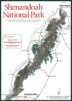
Located just 75 miles west of Washington, D.C., Shenandoah National Park today attracts nearly 2 million visitors a year. Between Front Royal in northern Virginia and Afton Mountain at Waynesboro, the park drapes across the crest of the Blue Ridge mountains, which form the eastern rampart of the Appalachian Mountains. These mountains are lower than the lofty peaks of Virginia's Blue Ridge Highlands south of Roanoke. Hawksbill, the highest peak in the park, is just 4,050 feet, compared to Mount Rogers's 5,729 feet in the southern section of the Blue Ridge.
Skyline Drive, the winding two-lane federal highway, divides the park as it extends 105 miles from Front Royal to Waynesboro. Some 75 overlooks provide visitors with expansive views of the Shenandoah Valley to the west and the rolling Piedmont country to the east. At the posted speed of 35 miles per hour, it takes three to five hours to drive the entire length, stopping at some of the overlooks. It is also permissible to stop wherever there is room to pull 6 to 12 feet off the road. The Drive is numbered from north to south with concrete mileposts from milepost 0 through milepost 105.
More than 95 percent of the once-abused land on both sides of the Drive is now covered with eastern deciduous forest with about 100 species of trees. To further protect the mountains, Congress in 1976 designated two-fifths of Shenandoah National Park as wilderness. In recent years, damage from ice storms, hurricane winds, flooding, and diseases and pests such as the gypsy moth have taken another toll.
 Elk
and wolves may be gone, but other animals that were once rare—white-tailed
deer, black bear, wild turkey, bobcats—have now returned. Deer are common
along Skyline Drive in early morning and late afternoon. As dusk falls, the
eyes of numerous white-tailed deer grazing the roadsides reflect car headlights
along the entire length of the Skyline Drive. (Because of problems with poaching,
it is illegal to stop and shine a light—even car headlights—on deer.)
Bears tend to stay in the back-country, but the population is so large in the
park that it isn't unusual to see a bear wander across a meadow or even the
mountain highway.
Elk
and wolves may be gone, but other animals that were once rare—white-tailed
deer, black bear, wild turkey, bobcats—have now returned. Deer are common
along Skyline Drive in early morning and late afternoon. As dusk falls, the
eyes of numerous white-tailed deer grazing the roadsides reflect car headlights
along the entire length of the Skyline Drive. (Because of problems with poaching,
it is illegal to stop and shine a light—even car headlights—on deer.)
Bears tend to stay in the back-country, but the population is so large in the
park that it isn't unusual to see a bear wander across a meadow or even the
mountain highway.
Raccoons, opossums, and skunks sometimes poke around campgrounds at night, searching for morsels left by campers. (It's not only dangerous but illegal to feed wildlife in the park.) Chipmunks entertain by day as they scurry across a campsite to a burrow under a fallen tree. More than 200 species of birds have been identified in the park, including 35 varieties of warblers.
Some 1,200 flowering plants grow in the park. In spring and early summer, a few examples to look for are spring beauty (Claytonia caroliniana), foam flower (Tiarella cordifolia), wild geranium (Geranium maculatum), solomon's seal (Polyganatum biflorum), New Jersey tea (Ceanothus americanus), and bowman's root (Gillenia trifoliata). In later summer, there's fragrant thimbleberry (Rubus odoratus), beard-tongue (Penstemon), sundrop (Oenothera fruticosa), and butterfly weed (Asclepias tuberosa).
The park has more than 500 miles of footpaths ranging from easy leg-stretchers to a 101-mile segment of the Appalachian Trail, which runs the length of the park. Several developed campgrounds along Skyline Drive provide car campers with places to hear ruffed grouse drumming or barred owls calling or to take part in day and evening interpretive programs. Primitive backcountry camping is also an option but requires a free permit.
Hunting is off-limits in Shenandoah National Park, but fishing for native brook trout is available year-round for those willing to walk to remote streams that tumble down both sides of the Blue Ridge. Only artificial lures may be used. On designated streams, the creel limit is six trout per day with a 9-inch minimum size. On all other streams open to fishing, catch-and-release regulations apply. A Virginia fishing license is required. A free brochure listing trout streams and regulations is available at entrance stations and visitor centers or by calling the park.
The park and Skyline Drive are most crowded in mid-October when fall foliage is at its colorful peak. Summer weekends will also find favored trails clogged with elbow-to-elbow walkers. One alternative is to plan visits for weekdays or, better yet, the off-season. But even at the peak of fall foliage, when the park may have 50,000 visitors in a single day, hikers who desire solitude can find it on the lesser- known trails. There's personal adventure in finding a waterfall or greenstone formation or identifying a wildflower that's not on a nature trail.
Besides interpretive programs conducted by park rangers, interested persons are invited to sign up for special workshops and activities from time to time. Examples include a wildflower weekend (usually the second weekend in May), a Fourth of July weekend butterfly count (nationwide program modeled after the National Audubon Society's Christmas Bird Count), and the Christmas Bird Count.
The park remains open year-round. The Skyline Drive, however—the only road through the park—is sometimes closed from dusk to early morning during hunting season to discourage illegal hunting, and it is closed when it's covered with snow or ice. Cross-country skiers sometimes use the park roads when they are closed to traffic. All facilities—lodging, campgrounds, waysides, visitor centers, gas stations—close in late fall and reopen in mid-spring.
 The
Shenandoah Natural History Association is a nonprofit organization that sells
books, maps, and related items at the two visitor centers. Income is used to
support the interpretive and educational programs of the park. Lodging, groceries,
and all items for sale in the park are provided by private concessionaires.
ARAMARK Virginia Sky-line Company, Inc., operates the lodges, restaurants, waysides,
gift shops, shower/laundry, and gas stations. The Potomac Appalachian Trail
Club is an association of hikers that maintains the Appalachian Trail and six
rental cabins in the park.
The
Shenandoah Natural History Association is a nonprofit organization that sells
books, maps, and related items at the two visitor centers. Income is used to
support the interpretive and educational programs of the park. Lodging, groceries,
and all items for sale in the park are provided by private concessionaires.
ARAMARK Virginia Sky-line Company, Inc., operates the lodges, restaurants, waysides,
gift shops, shower/laundry, and gas stations. The Potomac Appalachian Trail
Club is an association of hikers that maintains the Appalachian Trail and six
rental cabins in the park.
[Fig. 44(9)] One of the most fascinating places in the park also happens to be one of the most accessible. At mile 51.2—near the halfway point of the Skyline Drive—is Big Meadows. Its 150 open acres cover a bowl-shaped depression underlain by solid Catoctin greenstone rock. Springs and precipitation keep the nearly impermeable ground swampy through most of the year.
Just before dusk, deer materialize from the surrounding woods in the shrubby meadow to browse. Just as predictably, park visitors appear to wander the meadows and watch the nearly tame deer. But there's much more to see. In the sun-washed meadow thrive some 270 species of plants, including several varieties of ferns and the park's largest collection of wildflowers. Among the flower varieties are northern evening primrose (Oenothera biennis), Turk's cap lily (Lilium superbum), beardtongue (Penstemon), and stiff gentian (Gentiana quinquefolia) with its lovely lilac-blue open petals. The gentian grows about 1 to 2 feet tall and has a whorl of leaves just below the flower cluster.
Scientists say that Big Meadows was once much bigger—extending 1.5 miles north and south of its present 150 acres. But they can only speculate about its reason for being. Perhaps Indians set fire to the land regularly to keep it clear for hunting. The park now burns and mows the land to preserve its open character for nesting birds, deer, and other wildlife and for historical significance since the meadow has existed for several hundred years.
Motel-type units and rustic cabins are available from early April through November at Skyland (mile 41.7) and Big Meadows (mile 51.2). A few rental housekeeping cabins are available from early May to late October at Lewis Mountain (mile 57.5). Make reservations well in advance.
Four campgrounds with spacious, shaded sites operate from May through October. These campgrounds include Mathews Arm (mile 22.2, 186 sites), Big Meadows (mile 51.2, 227 sites), Lewis Mountain (mile 57.5, 32 sites), and Loft Mountain (mile 79.5, 221 sites). A fee is charged. Handicapped-accessible sites are available at each campground. Only Big Meadows Campground takes reservations either at the gate or by calling (800) 365-CAMP and using SHEN as four-letter designator when asked.
There are no trailer hookups. All but Lewis Mountain have a trailer sewage disposal site. Shower and laundry facilities are at Big Meadows, Lewis Mountain, and Loft Mountain. Primitive facilities (reservation required) for organized youth groups are at mile 83.7 at Dundo Campground.
Free backcountry camping is allowed by permits. They are available at park headquarters, visitor centers, entrance stations, and self-registration stations at Rockfish Gap (mile 104.4 at the south end), Swift Run Gap (mile 65.5 at US 33 interchange), and the Tom Floyd Wayside (on the AT just outside the park's North District). Self-registration for overnighters near Old Rag Mountain is at the Weakley Hollow access.
Although it would seem such a large area would have plenty of backcountry campsites, that's not necessarily the case. Remember: Shenandoah has more backcountry campers per square mile than any other national park. Camping is not permitted within sight of a trail, road, another camping party, or a sign that says "No Camping." Because of the steep terrain, flat spots to pitch a tent are in short supply during peak seasons. Hikers who can arrange their visits on weekdays or during the off-season are not as likely to be disappointed or to be tempted to camp illegally.
Seven picnic areas, all with picnic tables, fireplaces, drinking fountains, and restrooms, are at the following locations: Dickey Ridge (mile 4.7), Elkwallow (mile 24.1), Pinnacles (mile 36.7), Big Meadows (mile 51.2), Lewis Mountain (mile 57.5), South River (mile 62.8), and Loft Mountain (mile 79.5). Picnic tables are also on the lower level at Skyland and scattered along the Drive. Sites accessible to the disabled and the elderly are available at all park picnic areas, and restrooms are accessible with assistance.
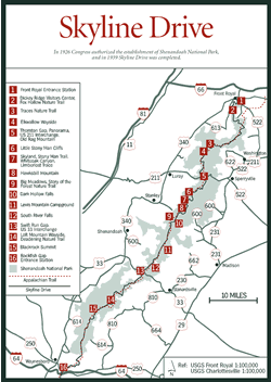
Mile .6: Front Royal entrance station. [Fig. 44(1)]
Mile 4.6: Dickey Ridge Visitor Center. [Fig. 44(2)] Information, exhibits, slide show, phone, restrooms, water, self-guided trail, access to Dickey Ridge Trail, adjacent picnic area.
Mile 24: Elkwallow Wayside. [Fig. 44(4)] Snack bar, campstore, gifts, gas, water, toilets, phone, adjacent picnic area.
Mile 31.5: Thornton Gap, US 211 interchange. [Fig. 44(5)] Access from Luray, Warrenton, and Washington, D.C. Exit here for Old Rag Mountain trailhead (See hiking section).
Mile 31.6: Panorama. [Fig. 44(1)] Restaurant, phone, gift shop, information, AT access, hiking trails, restrooms.
Miles 41.7—42.5: Skyland. [Fig. 44(7)] Restaurant, lodging, gifts, taproom, horseback riding, restrooms, self-guided trail, interpretive programs, hikes.
Mile 51.2: Big Meadows. [Fig. 44(9)] Gas, restaurants, lodging, picnicking, camping, interpretive programs, hiking trails, restrooms, visitor center, phone.
Mile 57.5: Lewis Mountain Campground. [Fig. 44(11)] Picnic area, cabins, interpretive programs, campstore, phone, campground, showers, AT access, hiking trails.
Mile 65.5: Swift Run Gap, US 33 interchange. [Fig. 44(13)] AT and US 33 crossing.
Mile 79.5: Loft Mountain Wayside. [Fig. 44(14)] Food, gas, water, restrooms, information center (seasonal), gifts, campground, picnic area, amphitheater, camp store, laundry, showers, trailer disposal station, interpretive programs, hiking trails.
Mile 104.6: Rockfish Gap entrance station. [Fig. 44(16)] Operated seasonally. Park information available.
Shenandoah National Park is a Mecca for hikers. Some 500 miles of trails lead to waterfalls, deep canyons, old-growth forests, remains of early settlements, and rocky outcrops with sweeping views of the Piedmont to the east and Shenandoah Valley to the west. Trail blazes are blue for foot travel and yellow for horses. In addition, about 101 miles of the white-blazed Appalachian Trail (AT) pass through the park, roughly paralleling the Skyline Drive. The trail was constructed with gentle grades so it is rarely steep. An infinite variety of hikes is possible by combining portions of the AT and park trails to make loops.
On June 27, 1995, an intense rainstorm caused major flooding in many park streams, altering the course of some of them. Then Tropical Storm Fran blew down thousands of trees across park trails and roads on September 6, 1996. Hikers will come upon numerous reminders of both events in the park for many years, as personnel struggle with limited funding to repair the damage.
Hikes to some of the park's most popular waterfalls are at the following mileposts. Three of these (Whiteoak Canyon, Dark Hollow, and South River falls) are further described in the sampling of park hikes below. Overall Run Falls (miles 21.1 and 22.2), Whiteoak Canyon Falls (mile 42.6), Cedar Run Falls (mile 45.6), Rose River Falls (mile 49.4), Dark Hollow Falls (mile 50.7), Lewis Falls (mile 51.2), South River Falls (mile 62.8), Doyles River Falls (mile 81.1), Jones Run Falls (mile 84.1). Tip: Take a flashlight to trails with west views so you can watch the sunset and have light for the return trip.
Here are a few examples of park hikes:
Fox Hollow Nature Trail (mile 4.6). [Fig. 44(2)] Easy, 1.2-mile, self-guided circuit to mountaineer homesites. Climb from 1,940 feet at trailhead across road from Dickey Ridge Visitor Center to 2,250 feet.
Traces Nature Trail (mile 22.2). [Fig. 44(3)] Easy, 1.7-mile, self-guided loop showing "traces" of old homesites, beginning at Mathews Arm Campground amphitheater parking area and climbing 335 feet.
Old Rag Mountain (Exit Skyline Drive at Thornton Gap, mile 31.5). [Fig. 44(5)] The tough, steep climb to the summit of Old Rag Mountain is one of the most popular hikes in Shenandoah National Park and in Virginia. Unlike most hikes in the park, this one begins at the bottom of the mountain instead of from the Skyline Drive.
Old Rag is a roundish mountain in the northern tip of Madison County, east of White Oak Canyon. The circuit hike from Weakley Hollow on the northeastern slope is a 7.2-mile, blue-blazed loop that climbs a grueling 2,380 feet to the 3,291-foot summit where the hiker is rewarded with beautiful views of the surrounding mountains and valleys. Take the Ridge Trail south out of the parking area to the summit and descend on the Saddle Trail on the northwest slope. Then use the Weakley Hollow fire road to return to the starting point.
Along the trail, hikers pass between vertical granite walls less than 3 feet apart. Underfoot is a rocky stairstep formation. The rocks are what is left of an ancient dike formed when molten lava poured out of a fissure in the granite. An early start is necessary to allow ample time to rest between stretches of boulder climbing and treks up steep slopes. (Overnight trips are not allowed.) Despite the terrain, on a summer weekend the summit may be filled with hikers enjoying the outstanding views. Hikers over the age of 16 now pay a fee to climb Old Rag. A collection box is at the trailhead.
Each June, nearby Graves Mountain Lodge hosts a popular three-day bluegrass music festival on the grounds beside the Rose River. The picturesque river valley and the Blue Ridge mountains make the perfect background for the bluegrass, including some of the country's best-known bands. Graves Lodge is noted for its home-cooked food served at long tables, family style. Camping is available during the festival, but lodge rooms are reserved for the bands. Contact the lodge at (540) 923-4231 for festival tickets or meal reservations, which are required.
Little Stony Man Cliffs (mile 39.1). [Fig. 44(6)] Moderate .9-mile round trip, climbing 270 feet to cliffs with outstanding views of Stony Man, Marys Rock, and the Pinnacle. The Little Stony Man cliffs are composed of greenstone formed in ancient times from what is called the Catoctin lava flows. With each new eruption (there were at least a dozen in the park), the lava reached higher and higher on granite hillsides, eventually covering all but the highest peaks.
Stony Man Nature Trail (mile 41.7). [Fig. 44(7)] Self-guided, 1.6-mile round trip that climbs gradually from 3,670 feet at the trailhead to panoramic views on the summit of Stony Man Mountain (elevation 4,010 feet), the second highest point in the park. Hike is mostly easy, with strenuous sections. American mountain-ash grows near the summit. Squirrels, ruffed grouse, and many songbirds eat the tree's bright red berries in late summer and early fall. A small copper mine was also located near the summit in the early 1800s.
Whiteoak Canyon (mile 42.6). [Fig. 44(7)] One of the most beautiful and sought-after areas of Shenandoah National Park is this deep gorge with its six waterfalls, sheer cliffs, giant boulders, old hemlocks, and floor of ferns and mosses. A round trip to the first and tallest of the falls is 4.6 miles. This trail passes through the giant hemlocks of the Limberlost (see Limberlost Trail). To reach the first falls, descend from 3,510 feet at trailhead parking to 2,470 feet. Park naturalists have identified false helibore (Veratrum viride) on the trail.
Below the first falls, the trail is steep. It's another 2.7 miles and 1,110 feet down to the last waterfall. Tip: Come on weekdays or, better yet, in the off-season. Whiteoak Canyon can be a busy place on summer weekends and during fall foliage.
Limberlost Trail (mile 43). [Fig. 44(7)] Easy, gently sloping, 1.3-mile loop (handicapped accessible) through ancient hemlocks, from 350 to 400 years old. Trail is improved with frequent benches, a 65-foot bridge and 150-foot wooden boardwalk, and hard-packed crushed greenstone walkway. The acidic soil formed by decaying evergreen needles and the low light combine to make impossible conditions for all but the most shade-loving understory plants such as mosses, ferns, and lichens. An obvious question is why the hemlocks were spared when everything around them was logged. Credit goes to the founder of Skyland, a recreation area here even before the park was created. George Freeman Pollock paid lumbermen $10 a tree to leave the hemlocks standing. Incidentally, Pollock is also credited with influencing a study commission in 1924 to recommend to Congress that the Blue Ridge be the site of a national park.
Hawksbill Mountain (mile 45.6). [Fig. 44(8)] Difficult 1.7-mile round trip from 3,365 feet to Hawksbill summit (elevation 4,050 feet), the highest point in the park. The trail crosses talus slopes, or boulderfields, beneath sheer cliffs of Catoctin greenstone. With repeated freezing and thawing, the rock broke from the cliffs thousands of years ago and tumbled down the slopes. Note the lichens, mosses, ferns, and hardy plants such as yellow clintonia (Clintonia borealis), Alleghany stonecrop (Penthorum), flowering spurge (Euphorbia corollata), and sedums that have adapted to the scant soil.
The Shenandoah salamander (Plethodon shenandoah) is found here and two other places in the park (Stony Man Mountain and the Pinnacles). The body is dark brown. In one color phase the salamander has a narrow red-to-yellow stripe down the center of the back. In a second phase, the back is uniformly dark brown with scattered gold-colored flecks. The amphibian dwells in the soil that has collected among the rocks of north- and northwest-facing slopes above 2,900 feet.
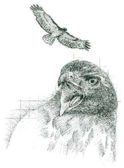
On the summit is an observation platform with panoramic view, Byrds Nest Shelter No. 2, and picnic table. This is the best place in the park for watching the fall migration of hawks and other birds of prey.
Dark Hollow Falls (mile 50.7). [Fig. 44(10)] Moderate, 1.4-mile, heavily used trail from 3,425 feet at parking area down to beautiful waterfalls at 3,130 feet. Stay on the trail to avoid slippery, dangerous rocks at top. Falls drop 70 feet over greenstone remaining from ancient lava flow. Trail goes below falls to Rose River fire road at 2,985 feet.
Story of the Forest Nature Trail (mile 51). [Fig. 44(9)] Easy, 1.8-mile, self-guided circuit featuring succession from meadow to forest. Elevation change is from 3,510 feet at Byrd Visitor Center trailhead to 3,800 feet.
South River Falls (mile 62.8). [Fig. 44(12)] Easy-to-moderate, 2.6-mile round trip (steady climb of 850 feet on return) along old stone walls and old fields and down to gorge with view of falls and Saddleback Mountain. Flowering spurge (Euphorbia corolata) grows 1 to 3 feet high along the trail. Like its relative, the Christmas poinsettia (E. pulcherrima), the tiny true flowers are surrounded by what look like petals (white on the flowering spurge, red on the poinsettia) but are actually petal-like bracts.
Deadening Nature Trail (mile 79.4). [Fig. 44(14)] 1.4-mile self-guided circuit from pastureland to mature forest. Chestnut stumps show evidence of girdling or "deadening" once practiced by mountain people to allow sunlight through canopy for crops or pasturelands. At the top is a spectacular view of Big Run watershed to the west.
Blackrock Summit (mile 84.8). [Fig. 44(15)] 1-mile, easy round trip along talus slopes (boulderfields) of Hampton quartzite. Spectacular view.
Read and add comments about this page