 Sky
Meadows State Park Sky
Meadows State Park
Sky
Meadows State Park Sky
Meadows State Park [Fig. 45] Just an hour's drive from the nation's capital, Sky Meadows State Park provides a natural respite of pleasant pastures, hiking trails, rolling woodlands, old stone fences, and distant views from the eastern slopes of the Blue Ridge Mountains.
This is a low-key park, designed for those who like natural history, quiet woodland walks or rides on horseback, birdwatching, wildflower identification, deer watching, and the savoring of pastoral views that have changed little since the Civil War raged across these valleys and mountains. Sky Meadows is aptly named. A former owner, Sir Robert Hadow, thought the mix of hills and meadows looked a lot like his native Scotland. Hadow called the property Skye Farm. The land changed hands several times over the years. When philanthropist Paul Mellon donated a total of 1,618 acres for development of the state park in the 1970s and 1980s, his contributions brought the total land area to its present 1,862 acres.
Sky Meadows State Park is a place of unusual beauty, but it doesn't have many of the developed facilities that attract large crowds. There are no big lakes, only a children's fishing pond. The 12 campsites are primitive, and to reach them one has to hike .75 mile from the visitor center. But the park offers hiking trails and a horse trail, equine facilities, picnicking, fascinating interpretive programs, and a farmhouse/visitor center that is more than 150 years old. In May, Sky Meadows makes a great base camp for exploring the trillium-covered slopes of bordering Thompson Wildlife Management Area (WMA). The two are connected by the Appalachian Trail.
Sky Meadows is a beautiful place to walk or to sit and think about mountains, wildflowers, wildlife, and Virginia history.
Trails of Sky Meadows State Park
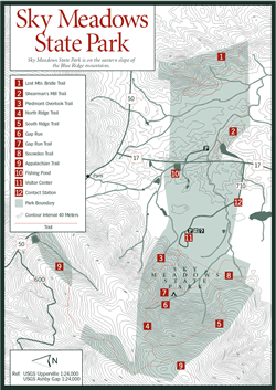
Six hiking trails, plus a 3.6-mile stretch of the Georgia-to-Maine Appalachian Trail (white blaze), climb the high meadows and ridges of the park. By combining portions of the trails, several loops are possible. From a service road at the west end of the visitor center, the red-blazed Piedmont Overlook Trail [Fig. 45(3)] climbs .7 mile through a field of wildflowers to connect with the blue-blazed North Ridge Trail [Fig. 45(4)]. Hikers can use this trail to descend and make a circuit, or continue uphill another .3 mile on the North Ridge Trail to the orange-blazed Gap Run Trail. Go left on Gap Run Trail [Fig. 45(7)] to descend to the primitive campground or continue along the North Ridge Trail .6 mile to a .3-mile spur climbing steeply to the AT.
For a picturesque return trip, at the junction with the North Ridge Trail [Fig. 45(4)] and the AT spur, take the yellow-blazed South Ridge Trail [Fig. 45(5)]. This path leads 1.6 miles first along an old road in the woods, then through grass pastures with expansive views to a connection with the lower end of the Gap Run Trail [Fig. 45(7)]. Go right to return to the visitor center. On the way back, the Gap Run Trail passes by a connection with the 1.1-mile interpretive loop of the Snowden Trail [Fig. 45(8)]. Equestrians have exclusive rights to the challenging and scenic Lost Mountain Bridle Trail [Fig. 45(1)]—a 4.6-mile loop that includes an .8-mile access trail.
Read and add comments about this page