 The
Big Frog Wilderness The
Big Frog Wilderness
The
Big Frog Wilderness The
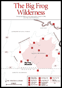
Big Frog Wilderness The Cohutta Wilderness extends into Tennessee as far as the Eastern Continental Divide. Protruding from it is the isolated hulk of Big Frog Mountain [Fig. 15]. Big Frog is not a high mountain (4,224 feet), but, like Grassy Mountain (3,692 feet) in the Cohuttas, it appears more dominant because it stands alone. Lacking the protection of other mountains, it receives the full impact of cold fronts and other climatic events. In addition, it receives high rainfall. Big Frog is a scenic mountain. The top is forested; northern hardwoods are present, as is a boulderfield on the north side. Big Frog was designated a wilderness by Congress in 1984 and expanded in 1986. It totals 8,055 acres, 83 of which are in Georgia.
COPPERHILL ACCESS. From Blue Ridge take GA 5 north to the Tennessee line. Pass through Copperhill and in about 2 miles take GA 251 west. Cross the Ocoee River and continue on GA 251 for 5.8 miles. Cross Tumbling Creek and intersect FS 221. Turn north on FS 221, Peavine–Sheeds Creek Road. Off this road, pass five trailheads to Big Frog Mountain. Note that at each trailhead, the distance from the trailhead to Big Frog Summit is given. At 2 miles, pass Tumbling Creek Campground [Fig. 15(7)]; at 5.6 miles reach Licklog Ridge Trail [Fig. 15(6)] (5.6 miles to summit); at 8.4 miles reach Big Frog trailhead [Fig. 15(2)] (5.2 miles to summit); at 13.1 miles reach Yellow Stand Lead Trail [Fig. 15 (3)], which ties into Big Frog Trail (5.4 miles to summit); at 13.2 miles reach Big Creek trailhead [Fig. 15(4)] (5.2 miles to summit); at 14.8 miles reach Wolf Ridge trailhead [Fig. 15(5)] (7.6 miles to summit); at 17.2 miles pass the turnoff on Big Frog Road (gated); and at 18.8 miles reach a fork in Alaculsy Creek Valley. Turn south on FS 221. Just north is the Sylco Campground. Continue down FS 221, but go straight when FS 221 turns west at 22.8 miles. One will reach Cisco on US 411 in 8 to 10 miles.
OCOEE RIVER ACCESS. From Copperhill north on TN 68, go 28 miles to US 64 intersection. Take US 64 west and go 8 miles. Take the first left road [Fig. 15(1)] after the highway begins running along the river. Just below this is the put-in for rafting the famous Ocoee River. After crossing the river one passes the USFS Thunder Rock Campground. Go 4 miles to intersect the Peavine–Sheeds Creek Road (FS 221) between Licklog Ridge (east) and Big Frog (west) trailheads. Note: It is well worth a few moments to drive down the Ocoee River Gorge just to watch the rafts go by. This whitewater trip rivals the Chattooga in excitement, but not as a wilderness experience, since US 64 closely follows the Ocoee.
CHESTNUT MOUNTAIN TRAIL. [Fig. 15(8)] Approximately 10 miles east of US 411 on FS 221 (Peavine–Sheeds Creek Road), turn east on FS 62 and go 6 miles to the trailhead. Hike 3.2 miles to Big Frog summit along Chestnut Mountain and Wolf Ridge.
Read and add comments about this page