 Carters
Lake Carters
Lake
Carters
Lake Carters
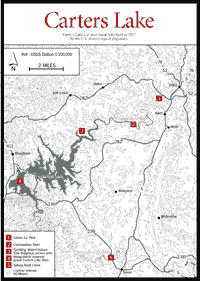
Lake Located 12 miles south of Chatsworth off US 411, 3,500-acre Carters Lake [Fig. 16] was constructed by the U.S. Army Corps of Engineers in 1977. The lake provides many recreational opportunities including boating, swimming, camping, hiking, and fishing. A large area near the dam on the south shore has been developed by a concessionaire as the Blue Ridge Mountain Marina Resort. In a road cut below the dam one can see the Cartersville–Great Smoky Fault where Western Blue Ridge rocks rest against those of the Great Valley.
A map is available at the resource manager's office. Here, also, reservations can be made for campsites at Doll Mountain, Woodring Branch, and Harris Branch.
Harris Branch Park. Group camping only. Shelter, 6 tables, large grill, 10 tent pads, running water, comfort station.
Doll Mountain Park. 55 campsites, 39 with electrical and water hookups; 2 comfort stations with shower facilities and a recreational dump station.
Ridgeway Park. 22 primitive campsites with pit toilets, boat ramp, and dock. Accessible by dirt road only. No charge.
Woodring Branch. 32 campsites, all with electrical and water hookups; comfort station; and boat ramp. Another 12 campsites with pit toilets and a hand-operated water pump are available.
Blue Ridge Mountain Marina Resort. Cabins and rooms, rental houseboats, convenience store, pontoon and fishing boat rental, guided fishing trips, snack bar, and boat repair.
A map is available at the resource manager's office.
Hidden Pond Trail. About .5 mile. The trail was constructed to provide access sites for bird watchers. Two bridges are part of the trail; one 20-foot bridge spans the stream near the entrance to the management area and a 210-foot structure crosses a beaver pond. An observation platform upstream at the edge of a second beaver pond provides a view of an active beaver lodge and offers an excellent opportunity for viewing waterfowl. Located near the entrance to the management area.
Tumbling Waters Nature Trail. [Fig. 16(3)] Travels approximately 1 mile through a secluded valley carved by a mountain stream. The trail includes two viewing platforms located above a cliff from which hikers can view Tails Creek cascading into Carters Lake. Trailhead located in Ridgeway Park.
Big Acorn Nature Trail. About .2 mile. Easy trail along a wood-chip path. Signs identify trees and shrubs. The trailhead is at the Carters Lake Visitor Center.
Ridgeway Mountain Bike Trail. The Ridgeway Recreational Area on Carters Lake is maintained by the Army Corps of Engineers. The trail is a 5.6-mile loop around Carters Lake that can be shortened or lengthened by taking the various trails branching off of it. The trail is narrow, fairly technical with a lot of ups and downs, and a good ridge for intermediate to advanced riders. Races are held here in the spring and fall, and downhill races are held at Carters Lake Dam. Be careful if you ride after a rain because the trail does get muddy, which is hard on the rider and the trail. Bathrooms, primitive camping, picnic tables, and drinking water are available near the trailhead. You can also take a swim in the lake to cool down after a hot ride. Camping with full facilities and beaches are available on the other side of the lake.
Carters Lake is a great place for a full-day outing of mountain biking, hiking, swimming, and boating. The overlook areas offer spectacular views, and the waterfall near the end of the trail is one of the most beautiful in Georgia.
The Coosawattee River. [Fig. 16(2)] The Cartecay and Ellijay rivers meet in the town of Ellijay to form the Coosawattee, one of the largest rivers in north Georgia. Once out of town, the river turns west through the southern Cohuttas, carving downward more than 500 feet in 22 miles through a spectacular gorge and emerging through a narrow breach into what geologists call the Great Valley. The highest earthen dam east of the Mississippi now fills that breach, and Carters Lake has inundated more than half the river, including the biggest rapids and the highest cliffs.
This gorge was second only to Tallulah Gorge in grandeur. In fact, canoeing insiders believe that James Dickey's novel-turned-movie, Deliverance, which was filmed on the Chattooga, was actually written more with the Coosawattee in mind.
The upper section remains a fine run of intermediate difficulty, past forested bluffs. Because of the open nature of this river, with wide views of the surrounding trees, it is most scenic in April, when the woods are leafing out, and in October, during the fall color display. Although the river gradient is almost 30 feet per mile in places, the rapids do not exceed Class III and are separated by easy, flat sections which allow paddlers to relax and enjoy the scenery.
Talking Rock Creek. [Fig. 16(5)] Talking Rock Creek is a beautiful, clear mountain stream deeply etched into the canyonlike foothills of the Cohutta and Blue Ridge mountains, just northwest of Jasper. Generally running northwest, it empties into the reservoir below Carters Lake Dam. Canoeists experience wild and remote country, high cliffs, and primitive mountain scenery, as well as Class I–III rapids.
Map References: For Cohuttas, Rich Mountain, and Big Frog USGS 1:100,000 series: Cleveland–Dalton–Cartersville. USGS 1:24,000 series: Cashes Valley–Blue Ridge–Wilscot–Ellijay–Tickanetley Noontootla. For Big Frog, USGS 1:24,000 series: Epworth–Ducktown–Hemp Top–Caney Creek. County Highway Maps: Gilmer–Murray–Fannin–Gordon.
Read and add comments about this page