 The
Chattooga River The
Chattooga River
The
Chattooga River The
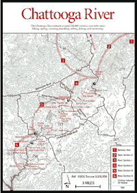
Chattooga River The Chattooga River is the crown jewel of southern whitewater rivers and a symbol for wilderness river lovers throughout the United States and Canada. Its high rainfall, unusual geology (with many cliffs, gorges, and waterfalls), and steep gradient place it in the "world class" category of rivers. Most remaining rivers of the Chattooga's quality are tucked away in western gorges or West Virginia mountains. The river is arguably the area's prime single natural attraction, luring some 100,000 visitors a year for hiking, rafting, canoeing, kayaking, tubing, fishing, swimming, or plain and simple river watching.
Headwaters of the Chattooga are in the Nantahala National Forest and private lands in North Carolina. Flowing southward out of North Carolina, they form approximately 40 river miles of boundary between Georgia and South Carolina. The river drops from approximately 3,000 feet elevation at its headwaters to 950 feet at its termination into Lake Tugalo. It is under the control and protection of the Sumter National Forest in South Carolina, the Chattahoochee National Forest in Georgia, and the Nantahala National Forest in North Carolina.
The names of the river's rapids and other landmarks bear witness to the area's early inhabitants. Indian names translated into English have become Sock'em Dog, Shoulder Bone, and Cutting Bone Creek. Local settlers' humor shows in the names of two feeder creeks—Bad Creek and Worse Creek—both now covered by Lake Tugalo. Between those two streams is Sinking Mountain, named because of the instability of the soil and underlying decayed rock.
 The
Chattooga was designated a National Wild and Scenic River by Congress in May
of 1974. As a result, no motorized vehicles are allowed within a .25 mile of
its banks. In addition, man-made facilities are minimal, consisting primarily
of maintained hiking trails. Primitive toilet facilities and water are available
at camping areas. As a result of the minimal disturbance by man, the Chattooga
and its corridor provide a clean, litter-free hiking or rafting experience.
However, the growth in population in the mountain areas and resulting activities
could pose a multifaceted danger to the river in the future.
The
Chattooga was designated a National Wild and Scenic River by Congress in May
of 1974. As a result, no motorized vehicles are allowed within a .25 mile of
its banks. In addition, man-made facilities are minimal, consisting primarily
of maintained hiking trails. Primitive toilet facilities and water are available
at camping areas. As a result of the minimal disturbance by man, the Chattooga
and its corridor provide a clean, litter-free hiking or rafting experience.
However, the growth in population in the mountain areas and resulting activities
could pose a multifaceted danger to the river in the future.
The Chattooga is divided into five sections, Section 0–Section IV. Section 0 includes the entire headwaters region from Whiteside Mountain southward to Russell Bridge (GA 28). Sections I–IV cover the portions of the river open to boating, including the West Fork (Section 1) southward to Section IV and the river's end at Lake Tugalo.
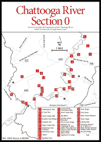 Section
0–The Headwaters
Section
0–The Headwaters BURRELL'S FORD BRIDGE. [Fig. 43(4), Fig. 48(11)] FS 646 begins .5 mile west of Russell Bridge (GA 28). Follow FS 646 for approximately 5.5 miles to Burrell's Ford Bridge. See Ellicott Rock section, Foothills Trail; Spoon Auger Falls; and King's Creek Falls.
BULL PEN BRIDGE. [Fig. 48(2), Fig. 50(6)] Follow SC 107 south from the intersection of US 64 in Cashiers, North Carolina. Turn west on Bull Pen Road and follow it to the bridge. See Highlands section, Horse Cove Road and Bull Pen Road.
CHATTOOGA RIVER TRAIL. The southern end of the Chattooga River Trail begins in Georgia in the parking area at the west end of the US 76 bridge [Fig. 42] and continues north for 10 miles, where it intersects and combines with the Bartram Trail. The combined trails continue another 10 miles to the GA 28 bridge, where the hiker must cross the bridge and pick up the trails on the South Carolina side. At a point 3.7 miles above the bridge, the Bartram Trail branches off to the east with the Foothills Trail, while the Chattooga River Trail joins with the Foothills Trail and parallels the river closely for another 6.7 miles to Burrell's Ford Campground and Burrell's Ford Road. In this section trails split and come together again many times; a trail map is useful. One-half mile north of Burrell's Ford Road, the trail enters the Ellicott Rock Wilderness. Here the hiker must register. The Foothills Trail branches off to the east at this point and the trail to Ellicott Rock continues upstream for 2.1 miles, where it joins with the East Fork Trail and continues 2.5 miles to Walhalla Fish Hatchery. The East Fork Trail continues 1.7 miles upstream to Ellicott Rock where Georgia, North Carolina, and South Carolina's boundaries meet [Fig. 48(5), Fig. 50(9)]. Ellicott Rock can also be reached by foot from North Carolina (see Ellicott Rock Wilderness). The only camping area with restroom and water facilities is the Burrell's Ford Campground. Other camping areas are primitive, and in some areas in the Ellicott Rock Wilderness camping is forbidden.
 THE
CHATTOOGA ABOVE BULL PEN ROAD. The upper
Chattooga River harbors some of the river's most scenic and rugged stretches.
Closed to boats, the area must be reached by foot.
THE
CHATTOOGA ABOVE BULL PEN ROAD. The upper
Chattooga River harbors some of the river's most scenic and rugged stretches.
Closed to boats, the area must be reached by foot.
This section of the river is known for the steep, remote Chattooga Cliffs [Fig. 50(3)] and for a small gorge area called the Upper Narrows. Both areas can be reached from the Bull Pen Road Bridge [Fig. 48(2), Fig. 50(6)], known locally as the "metal" or "government" bridge. It is recommended that the hiker have a car waiting at the bridge before beginning the walk upstream. Major access points are Bull Pen Road and primitive roads off Whiteside Cove Road. Both Bull Pen Road and Whiteside Cove Road are gravel and accessible by car.
Along this stretch the Chattooga is narrow and wild. Farther upriver, the grade is relatively flat, but the adjacent cliffs and overhangs provide constant interest. Here the rare Biltmore sedge, a northern club moss, and forests of giant mountain laurel up to 30 feet tall are present at the base of the cliffs. Farther downstream one reaches the Upper Narrows, where the rushing water is compressed into a stream about 6 feet wide. Only the most skilled rock climber can maneuver through the gorge. For a safer route, it is recommended that the hiker walk the gorge's edge. Downstream from the Upper Narrows, a loop trail is reached. This trail consists of a lower and upper section. The lower section affords good views of the boulder-strewn gorge which is found just upstream from the Bull Pen Road Bridge. Car-sized boulders and unusual potholes are present, as well as several nice swimming pools.
Below the bridge the river is less scenic but still worth the visit. Two trails off Bull Pen Road lead to Ellicott Rock.
THE CHATTOOGA HEADWATERS FROM GA 28, BURRELL'S FORD BRIDGE TO RUSSELL BRIDGE. [Fig. 48(11)] Unlike some parts of the river, this section is relatively accessible. Old log roads up the East Fork and the splendid trail up the entire South Carolina side afford all degrees of hiking and fishing experiences (see Ellicott Rock section).
While the river itself is not constant whitewater, areas are breathtakingly wild and scenic. The area between the Big Bend [Fig. 43(10)] and Lick Log Falls [Fig. 43(24)] is a challenge for the most intrepid fisherman, since there are no riverside trails. Crossing the river back and forth is essential and is risky in winter and spring high water. The wild isolation of the Rock Gorge [Fig. 43(20)] and the magnificence of the Big Bend Falls make it worthwhile. Prior to the construction of FS 646 (New Burrell's Ford Road), major accesses were at the Russell Bridge [Fig. 43(27), Fig. 44(29)] and from SC 28 near Big Creek (Old Burrell's Ford Road, 7 miles of torturous mountain road). This was part of the "mystery river" (see West Fork section), the area known for large brown trout. The river is open for fishing year-round.
For easy hiking and fishing, the section of the Chattooga between Russell Bridge and Reed Creek [Fig. 43(23), Fig. 44(26)] is hard to beat, for there is a trail (or log road) on either side. At the north side of the Russell Bridge, one looks out over a marsh with ponds and wood-duck boxes. This was the old Whitmire place, formerly a fertile cornfield. When it was acquired by the Forest Service, beavers promptly dammed up Mose Branch, creating a marsh dominated by alder shrub, sedges, and marsh grasses. One can go up the river by climbing down the bridge riprap or, more easily but less speedily, by taking the (gated) first road [Fig. 43(26), Fig. 44(28)] that turns off west of the bridge. About a mile up this road (1.75 miles by river) are some beautiful pools and camping places [Fig. 43(25), Fig. 44(27)]. Farther on there is an old field, called Reed Creek Bottoms, planted in loblolly pine [Fig. 43(22), Fig. 44(25)], which is rare in the mountains unless planted. Here one can turn up a trail on the west side of the field that leads up Reed Creek. Soon there will appear one of the most beautiful stands of white pine in north Georgia, with abundant patches of club moss and pink lady slippers [Fig. 43(17), Fig. 44(24)]. Farther on one enters Reed Creek Gorge [Fig. 43(15), Fig. 44(22)]. There are no trails in this section. The cascades, falls, and pools are extremely scenic and not too difficult to negotiate. With luck the visitor will see the highest of the falls, Reed Creek Falls [Fig. 43(12), Fig. 44(21)], before a more tranquil section leading up to Persimmon Gap [Fig. 43(8), Fig. 44(19)].
On the main river above Reed Creek there is more entrancing scenery, especially beginning at Lick Log Falls [Fig. 43(24)]. This area is most easily reached from the old Nicholson Ford Road. Above this, around a long "square" bend, the road is fairly high above the river [Fig. 43(18)]. The observant visitor may see signs of wild hogs rooting. This is truly backcountry, in spite of the old log roads that turn up the mountain, skipping the rock gorge entirely. On the approach to the gorge [Fig. 43(19)] one may see the beautiful mountain camellia, whose large, white blossoms appear in late summer. This is a plant found in streamside zones and on most bluffs.
It is difficult to negotiate the gorge [Fig. 43(20)], even with nonslip shoe soles. This can be a dangerous section. Towering cliffs appear, and the only way out is at least 1 mile farther upstream, reached by wading and rock hopping. Where the main Chattooga River Trail on the South Carolina side comes down to the river after going high around the gorge, there is a waterfall with a beautiful falls and pool below [Fig. 43(16)]. Although unnamed, this falls and the section above it [Fig. 43(14)] are alone worth the trip. At the next huge pool upstream there is a trail leading up to an east-west ridge. Big Bend Road leads off to SC 107, the easiest access to the river above the rock gorge. Above this pool (and branch) is another 1.5-mile section that has no trail. The main trail cuts across a ridge and comes down just above Big Bend Falls [Fig. 43(10)]. A side trip down to the falls is worth the exertion. At the Big Bend [Fig. 43(13)], one will see pieces of truck axle sticking out of the rock, evidence of a former logging bridge. As unlikely as it may seem, trucks with light loads were able to haul logs up the steep ridge on the South Carolina side, now an access trail. Farther upstream, the remaining several miles of river up the "Steps" [Fig. 43(9)] are a pleasant, beautiful riverside hike, with more whitewater and fewer huge pools than above Burrell's Ford Bridge.
All boating is prohibited upstream of the GA 28 bridge [Fig. 43(25), Fig. 44(29)].
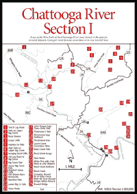 Section
I–The West Fork
Section
I–The West Fork The West Fork of the Chattooga River begins at Three Forks [Fig. 44(15)], the intersection of Holcomb, Overflow, and Big creeks. From there the West Fork flows 7 miles to the southeast to meet with the Chattooga. The entire West Fork, plus 1 mile upstream along Overflow Creek, is included within the boundaries of the Chattooga National Wild and Scenic River.
The upper portion of the West Fork is one of the most beautiful river sites in Georgia—a river of low falls and deep green pools hemmed in by bluffs and steep forested slopes. From Overflow Creek Road bridge down to the junction with the Chattooga, the river is relatively calm with long, deep pools ideal for lazy floating or swimming. Fine picnic and strolling sites are accessible and reached by road.
This is a country of beautiful but unknown waterfalls. One is on Overflow creek just above Three Forks. There are three falls on Big Creek; the middle one is outstanding. It is along the West Fork's headwaters that the last remnants of the old splash-dam logging system can be seen.
Formerly, Old Burrell's Ford Road offered the only former access to the Chattooga's East Fork, which, in the 1940s, was discovered to be Georgia's famed "mystery river." Large brown trout kept turning up, but no one would reveal their source until it was found that the inaccessibility of both the East and West forks had protected a remarkable fishing resource.
The West Fork is also an area rich in mining lore. The ultrabasic deposits along the lower river below Pine Mountain have yielded asbestos and soapstone and were the site of Georgia's most famous corundum mine at Laurel Creek. Most maps show that Laurel Creek, Reed Creek, and Warwoman Valley form one of north Georgia's most remarkable geologic features, a straight line or lineament, the "Warwoman Shear," that continues to control topography as far west as Tray Mountain.
After float logging divested the West Fork of much of its hardwood timber, white pine seeded in. Abundant by 1950, it was subsequently harvested, this time via log roads.
WARWOMAN ROAD BRIDGE. Follow Warwoman Road 14 miles east from Clayton.
OVERFLOW CREEK ROAD BRIDGE. Follow Warwoman Road 14 miles east from Clayton. Cross the West Fork, then turn left onto FS 86 (Overflow Creek Road) and follow approximately 1.3 miles to a one-lane bridge.
JOHN TEAGUE GAP AND THREE FORKS TRAIL. [Fig.
44(16)] While the Three Forks Trail originates on Rabun
Bald, it is most often hiked from John Teague Gap. From there it gently
descends through a forest typical for the area—oak-hickory slope forest
with scattered patches of white pines. At .7 mile the path crosses the blue-blazed
boundary of the Chattooga National Wild and Scenic River. Three-tenths of a
mile farther, it dips to a three-way intersection with an old jeep road. Here
the Three Forks Trail, occasionally blazed with white diamonds, turns left and
heads downhill following the road to a slab of bedrock overlooking a cascade
on Holcomb Creek. This is the end of the designated trail. The remainder of
the route down this gorge is on the north side of Holcomb Creek (cross the creek)
down a ravine with potholes and falls that reach all the way to Three Forks
(about .25 mile). It is not difficult bushwhacking, but one must pick a path
through
hemlock-rhododendron heath which, along with white pine, forms the bulk of the
streamside zone of vegetation.
FISHERMAN'S TRAIL. [Fig. 44(17)] The trail passes rock shelters and cliffs harboring colonies of wood rats.
OLD SPLASH DAM REMNANTS. [Fig. 44(12)] Around the turn of the century, loggers in this area built what were termed "splash dams" across creeks like Holcomb and Overflow. Cut logs were dragged down to the creeks and backed up behind the dam. At a prearranged signal, dams on several creeks were broken at one time, sending water and logs raging down the stream. Called "float logging," this method was used to harvest many of the slope forests, including streamside hemlocks. Logs from the West Fork were destined for Madison, South Carolina.
BILLINGSLEY CREEK ROAD. Built by the Forest Service so that Overflow Creek watershed could be logged.
TRAIL AND LOG ROAD. [Fig. 44(1)] Joins with Blue Valley and Clear Creek road system.
THREE FORKS. [Fig. 44(15)] The intersection of Holcomb Creek, Overflow Creek, and Big Creek divides the forest landscape into four neat quadrants and rewards determined hikers with the light, sound, and color of one of the most delightful scenes in Georgia. Other than by the Three Forks Trail route (see above), Three Forks can be reached via GA 28. See directions to High Falls on Upper Big Creek, below.
OVERFLOW FALLS. [Fig. 44(13)] Waterfall about .5 mile above Three Forks.
LOWER BIG CREEK FALLS. [Fig. 44(14)] Waterfall on Big Creek [Fig. 44(9)] and Upper Falls on Big Creek [Fig. 44(10)]. Old log road Fig. 44(8)] provides a good hike to Big Creek.
FALLS ON UPPER BIG CREEK. [Fig. 44(2)]
HIGH FALLS ON UPPER BIG CREEK. [Fig. 44(6)]
BURRELL'S FORD ROADS. In the 1940s reports filtered out of the north Georgia mountains of giant brown trout from a "mystery river." Eventually it was discovered that the mystery river was the Chattooga above Burrell's Ford, reached from Georgia only by Old Burrell's Ford Road (FS 121) [Fig. 43], which turns east off GA 28. The new Burrell's Ford Road (FS 646) turns north off GA 28 just before the Russell Bridge.
BUZZARD'S ROCK CLIFFS [Fig. 44(11)], HANGING ROCK CLIFFS by bushwhacking. Georgia's only location for sand myrtle is found on Cedar Cliffs. These cliffs are adorned with a picturesque spike moss, which forms thick, photogenic mats with twisted, hairlike spines. On Cedar Cliff Mountain is a rock shelter [Fig. 44(3)] containing evidence of both goats and the rare wood rat.
HEDDON CREEK FALLS. [Fig. 44(5)] This falls on Heddon Creek Road is accessible only by four-wheel drive. Just beyond the falls is a flat, swampy area, the site of a shrub bog.
LAUREL CREEK CORUNDUM MINE. [Fig. 43(11), Fig. 44(20)] Georgia's most famous corundum mine, unworked since 1894 when a huge block of peridotite fell, closing the tunnels. In addition to corundum, which is the second hardest mineral (only diamond is harder) and is used in the manufacture of abrasives for grinding and smoothing, the mine produced excellent specimens of blue and red corundum, though seldom of ruby and sapphire quality.
The peridotite outcrop covers several hundred acres including two rough, barren hills. The owners of the private land at the road terminus have not objected to hikers and parking. The trail can also be reached at the opposite end from Persimmon Gap on New Burrell's Ford Road (FS 646).
Directions: Laurel Creek is the first creek crossed going south from the junction of Warwoman Road and GA 28. After crossing the creek (about 1 mile), turn east.
PERSIMMON GAP TRAILHEAD. [Fig. 43(7), Fig. 44(18)]
DAM RUINS. [Fig. 43(21), Fig. 44(23)] Water was dammed to power a turbine which turned machinery for milling asbestos ore. The ore came from a mine just across the river on Dockins' Mountain. A nearby soapstone deposit at Adline Branch [Fig. 43(26), Fig. 44(28)] was cut into blocks with crosscut saws and used to build the blacksmith forge at the Laurel Creek Corundum Mine and to line local fireplaces.
The lower section of the West Fork, from Overflow Creek Road Bridge to the junction with the Chattooga, is a slow-moving, gentle stream suitable for the novice canoeist. Two Class II rapids, Dam Sluice and Big Slide, provide excitement for the beginner. The take-out is at Long Bottom Ford [Fig. 45(3)].
Map References: USGS 1:24,000 series: Satolah–Tamassee.
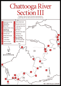
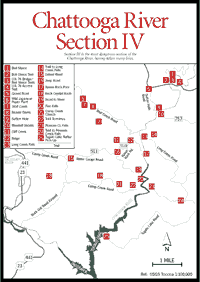
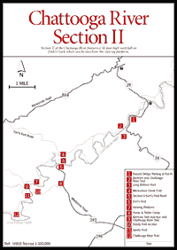 Sections
II, III, and IV
Sections
II, III, and IV These sections of the Chattooga accommodate those who enjoy the thrills of whitewater boating or watching others negotiate dangerous rapids. On the Georgia side of the river, a good hiking trail, the Chattooga River Trail, later joined by the Bartram Trail, parallels the river between the US 76 and SC 28 bridges. Below US 76 there are very limited trails along the river, and the gorge is navigable only by floating. At normal water levels, Section III is a good Class III run. At low water, outfitters avoid Section III and run Section IV, which extends from the US 76 bridge downriver to Lake Tugalo.
RUSSELL BRIDGE. [Fig. 44(29), Fig. 45(1)] Follow Warwoman Road 14 miles east from Clayton, cross the West Fork of the Chattooga, and go to the junction with GA 28. Turn right (south) on GA 28 and go approximately 3 miles to the bridge.
HIGHWAY 76 BRIDGE. [Fig. 47(3), Fig. 46(21)] Located 9 miles east of Clayton on US 76. This is the take-out for Section III and put-in for Section IV.
 ACCESS
TO RIVER
ACCESS
TO RIVER RUSSELL BRIDGE, LONG BOTTOM FORD PUT-INS. On SC 28, 1.25 miles south of the Russell Bridge is a parking and put-in area [Fig. 45(1)]. One-half mile below here a dirt road turns off south to Long Bottom Ford [Fig. 45(3)], where a low-water bridge and ford were the major river crossings for the early settlers around Pine Mountain on the West Fork. Boaters can put in here. Most cars can travel the road.
SOUTH CAROLINA ACCESS TO EARL'S FORD AND SANDY FORD. Downstream, Earl's Ford is the next point of access. At Mountain Rest, about 3.75 miles, turn right (south) on FS 196 and go 3.25 miles to a four-way stop at Whetstone; turn right (west) and go off pavement at 1.75 miles on a good gravel road for 1.25 miles. There is a camp specially designed to accommodate horses and horse trailers, and from it radiate horse trails that explore the area [Fig. 45(8), Fig. 46(4)]. If one turns left here on FS 721A, in 1.25 miles the river corridor is reached, and a trail leads .25 mile to the river. This is the Sandy Ford access [Fig. 45(10), Fig. 46(8)] from the South Carolina side. Continuing straight on Whetstone Road 1 mile past the horse camp, one reaches a parking area and trail to Earl's Ford [Fig. 45(6),Fig. 46(3)].
 GEORGIA
ACCESS TO EARL'S FORD AND SANDY FORD. Georgia has access to both Earl's
Ford and Sandy Ford, but the roads in are long, sometimes muddy, and are not
used by the commercial outfitters. The Georgia Earl's Ford Road access [Fig.
45(5), Fig.
46(2)] can be reached by ordinary car, except that in high water, Warwoman
Creek [Fig. 45(4),
Fig. 46(1)]
cannot be forded. (It is possible to drive, with care, to Sandy Ford.) In both
cases, roads go to the river's edge, unlike those in South Carolina. However,
the protective corridor extends .25 mile from the river. All vehicle traffic
is required to stay well away from the riverbanks.
GEORGIA
ACCESS TO EARL'S FORD AND SANDY FORD. Georgia has access to both Earl's
Ford and Sandy Ford, but the roads in are long, sometimes muddy, and are not
used by the commercial outfitters. The Georgia Earl's Ford Road access [Fig.
45(5), Fig.
46(2)] can be reached by ordinary car, except that in high water, Warwoman
Creek [Fig. 45(4),
Fig. 46(1)]
cannot be forded. (It is possible to drive, with care, to Sandy Ford.) In both
cases, roads go to the river's edge, unlike those in South Carolina. However,
the protective corridor extends .25 mile from the river. All vehicle traffic
is required to stay well away from the riverbanks.
On the Georgia side above Sandy Ford [Fig. 45(11), Fig. 46(9)] is a beautiful 50-foot-high waterfall on Dick's Creek. Take the Bartram Trail north [Fig. 45(9), Fig. 46(7)] about .5 mile past the Dick's Creek Ford to a side trail and viewing platform constructed by the U.S. Forest Service [Fig. 45(7), Fig. 46(5)].
FALLS CREEK ACCESS. This access is best approached off US 76. Two miles east of the US 76 bridge turn left (north) onto the Chattooga Ridge Road (FS 196), the first paved road to the left. Go 2 miles, take the gravel road (FS 722) left (west). At the second fork (2 miles), the right hand fork (FS 723) goes to an access point [Fig. 46(11)] with a very steep trail to the river (.25 mile). The left fork (FS 769) leads to a less steep but longer trail [Fig. 46(13)]. There are two lovely waterfalls on Falls Creek [Fig. 46(14)].
THRIFT'S FERRY. The next access is at Thrift's Ferry [Fig. 46(16)], reached by a gravel road that turns north about 1 mile east of the US 76 bridge.
US 76 SHOULDER ACCESS. Farther downriver, there is a special short access trail (parking is on US 76 shoulder) [Fig. 46(22), Fig. 47(4)] where some outfitters put in for short runs over Bull Sluice [Fig. 46(17), Fig. 47(1)].
BULL SLUICE TRAILS. There are two trails upriver to Bull Sluice, at high water levels a very dangerous, roaring, Class V rapid. Some visitors choose to walk up the better trail on the east (South Carolina) bank [Fig. 46(21), Fig. 47(3)] from the US 76 bridge parking area to watch the rafters come through the sluice. Photographers often prefer to walk up the west bank (Georgia) trail [Fig. 46(20), Fig. 47(2)], which is less well maintained but offers better views of the falls from below. (This is not the Chattooga River Trail. One has to walk too far on the Chattooga River Trail to reach Bull Sluice, while this trail is a short hike.)
WOODALL SHOALS. [Fig. 47(10)] This is a beautiful spot for picnicking and for swimming in the pool below the rapids. Do not attempt to swim or body surf Woodall Shoals. Rated a Class VI rapid, it is considered the most dangerous on the river. Given proper water levels, it can be run by or with professionals, but normally it should be portaged. Visitors should be content to explore below the rapid. On the east side of Woodall Shoals is one of the best places in north Georgia to see how Blue Ridge Mountain rocks have been metamorphosed by heat and pressure, as compared to the sedimentary- or "layer cake"- type mountains of the Cumberland Plateau in the northwestern part of the state. In fact, this site is said to be the "Rosetta Stone" for the interpretation of the changes that have taken place in the rocks of the Eastern Blue Ridge. Most of the rock at Woodall Shoals is a gneiss with black mica, but in it are dark bands and lumps of calcium-rich amphibolite, which furnishes good nutrition for nearby plant communities. Fresh rock is exposed here, courtesy of Mr. Woodall, who apparently dynamited the west side of the river several decades ago so his logs would not be trapped by the rapids along the east bank. Woodall Shoals is reached by turning right (south) 2.5 miles east of the US 76 bridge, and again right at the first gravel road to the right. It is about 2 miles to the parking and camping areas. Note that camping is prohibited here within the Wild and Scenic corridor.
LONG CREEK FALLS. [Fig. 47(13)] Below Woodall Shoals there is a beautiful falls on Long Creek, where most rafts stop for a swim and photographs. It can also be reached by a trail [Fig. 47(14)]. Turn south off US 76, 4.5 miles east of the US 76 bridge. After turning at Long Creek, go 2.5 miles, turn right (west) on FS 758, and go 1.25 miles; turn left onto a gravel road, which in 1.5 miles becomes a jeep road, and proceed until the trailhead is reached. This is Long Creek Road.
POSSUM CREEK FALLS. The Possum Creek Falls [Fig. 47(23)] is reached by a 1.5-mile trail which turns south in a bend [Fig. 47(24)] .5 mile off the paved road at Battle Creek, the same access to Long Creek Road.
TUGALO LAKE ROAD. The last access road on the South Carolina side is off Long Creek Road about 4 miles south of US 76. Turn right (west) onto the gravel Tugalo Lake Road. Be cautious in wet weather. This is the road used by buses to pick up rafters who have made the Section IV trip [Fig. 47(25)]. Length is 3.5 miles.
LICK LOG. Coming down the river on the Georgia side below Sandy Ford is the Lick Log access road [Fig. 46(6)]. It is reached by turning south off Warwoman Road at the Antioch Church turn-off to Sandy Ford, bearing left at the first fork (.5 mile), then bearing right at the second fork (about .25 mile). Then take the next left-hand road (FS 9). (See Rabun Bald, for road access from Warwoman Road.) These are gravel roads suitable for all vehicles.
FS 9 APPROACH. Another Georgia approach is off US 76 east from Clayton, 2.8 miles past the Willows. Turn north (left) on gravel road [Fig. 46(12)], go 3.5 miles, and take FS 9 [Fig. 46(6)] east (right) 3.8 miles to a gate. An old road [Fig. 46(10)] goes down a ridge to the river.
SUTTON HOLE ROAD. About .75 mile west of the US 76 Bridge, a gravel road (FS 290) turns south [Fig. 47(5), Fig. 46(19)]. Within .5 mile the short Sutton Hole Road (290A) [Fig. 46(23)] goes down to the river corridor, where the outfitters overnight their two-day-trip customers at Sutton Hole [Fig. 47(9)]. This is a jeep or pickup truck road, not for ordinary cars.
WOLF CREEK ROAD. This route requires about a 1-mile walk to the river. To reach it, turn right (east) off US 441, 4 miles north of Tallulah Falls Bridge, onto the second paved road to the right. Keep straight for about 3 miles (the road turns to gravel). Turn right (east) at the Wolf Creek Church sign (FS 515). This is an interesting area. From above the church along Wolf Creek, the strange, introduced Japanese paper plant grows wild [Fig. 47(6)]. Farther down Wolf Creek below the church are at least a dozen beaver dams [Fig. 47(8)]. A jeep can go down to within 1 mile of the Chattooga (stay on the right-hand road). This road leads to two potentially exciting areas which have not been much explored or apparently logged. The gorge of Cliff Creek [Fig. 47(11)] and lower Stekoa Creek (refer to Rainey Mountain quadrangle) are excellent places to explore.
CAMP CREEK ROAD. This is one of the most exciting access points to the Chattooga. It is a paved road 2.9 miles north of the Tallulah Falls Bridge, or 8.25 miles south of US 76, on US 441. After 1.5 miles, Water Gauge Road (FS 511) forks to the left off Camp Creek Road. Water Gauge is a good gravel road that dead-ends at a turnaround area at the river corridor after 4 miles. Drive with care; logging trucks and buses carrying rafters also use the road. There is an old road down to the river's edge [Fig. 47(19)]. Walking downstream along a thickly overgrown trail, one soon comes to the first of a series of Class V rapids [Fig. 47(20)] with names like Corkscrew, Jawbone, and Sock'em Dog. In good weather, it is quite a show to watch river runners go through this whitewater. A ford at or near the mouth of Camp Creek was evidently the main old settlers' route to South Carolina, a wagon road reportedly down which herds of hogs were driven to market.
Back about a mile from the terminus of Water Gauge Road (FS 511), Raven Rock Road (FS 511B) turns north, terminating at the Raven Rock trailhead [Fig. 47(12)]. A trail drops down .75 mile to the Raven Rock Pool [Fig. 47(17)], a grand, scenic place to have lunch, fish, and watch the rafters go by. Four-wheel drive is recommended for Raven Rock Road.
The trail terminates across the river from Raven Rock Cliffs, a 200-foot escarpment. Just upstream, Raven's Chute, a solid Class IV drop, challenges boaters.
The main Camp Creek Road continues south. At 2.6 miles N. Rock Mountain Road turns and comes out at Terrora Park on Tallulah Falls Lake. Camp Creek Road passes Camp Creek Church at 4.5 miles. Just west of it is a ridge that has yielded rock crystals, which also occur on a rocky knob several miles to the west [Fig. 47(18)]. On these rocky ridges and southward around Tallulah Gorge, the dominant pine is often the rare table mountain pine, with cones so prickly that it can hardly be handled. The Camp Creek paved road ends .3 mile past the church [Fig. 47(21)]. A jeep can go only another .5 mile; then one takes a trail. In this area, as in the area southward around Tallulah Gorge, the dominant heath is Carolina rhododendron, which has a purple bloom, as well as abundant azalea. At the terminus of the trail [Fig. 47(22)], one will be able to gaze off into the gorge of the Chattooga. This is the fabled "Sinking Mountain," where the visitor who stands long enough in one spot can feel the ground giving way underfoot. Bulldozers left overnight have been known to sink a foot or two. An Indian myth attributes this to a race of spirit people or "little people" who mined beneath the mountain, which is now caving in on their tunnels.
The Chattooga River is an outstanding whitewater experience that attracts boaters from all over the United States and Canada. While it is one of the finest recreational resources Georgia has to offer, it can be extremely unsafe—even deadly—for those who approach it unaware of its hazards. Many individuals, experienced as well as inexperienced boaters, have lost their lives in the river, particularly on Sections III and IV. A variety of books and maps details the river's boating pleasures and its dangers, and one or more of these resources should be consulted before attempting to navigate any section of the river. Reliable river guidebooks are listed in Appendix D. In addition, a number of outfitters provide canoeing and rafting expeditions on the Chattooga (see Commercial Rafting Trips, below). No one should attempt Sections III and IV of the Chattooga without first going with an experienced guide.
The Forest Service requires a minimum of two boats in any boating party, and each party boating on the Chattooga must register and provide proof of that registration on the river. Rangers frequently check for registrations at the take-out points and issue $50 fines if the registration is not produced. Registration booths are located at the Russell Bridge parking and put-in area, the Earl's Ford parking area, the US 76 bridge parking area, and the Woodall Shoals parking area. Boaters entering the river at a put-in location without a registration booth must first register at a site with such a booth.
SECTION II - GA 28 TO EARL'S FORD. [Fig. 45(5)] One Class III rapid (Big Shoals) and other shelflike rapids make Section II an excellent area for novice to intermediate whitewater boaters.
SECTION III - EARL'S FORD TO THE US 76 BRIDGE. [Fig. 47(3), Fig. 46(21)] At this point the river becomes much more dangerous, requiring greater expertise in negotiating boulders, gorges, and ledges. There are several Class III and IV rapids and one Class V at Bull Sluice, just above the take-out point near the US 76 bridge.
SECTION IV - FROM THE US 76 BRIDGE TO TUGALO LAKE. [Fig. 47(25)] The infamous Woodall Shoals, a Class VI rapid that has taken many lives, is located on this section a short distance below the bridge. From here on, the river narrows and concentrates into several Class IV and V rapids before entering Lake Tugalo where a 1.5-mile paddle across the lake to take out is required. Both Sections III and IV are dangerous and should be attempted only by experienced boaters.
Guided river trips are available from three local rafting companies—Southeastern Expeditions, Wildwater Limited, and Nantahala Outdoor Center, all carefully regulated by the federal government. These outfitters conduct canoe clinics and raft trips lasting from a half day to two days, with an overnight camp-out available. Commercial operations usually run from late March through October, depending on stream flow and weather. For a listing of outfitters, see Appendix C.
Map References: USGS 1:24,000 series: Cashiers–Highlands Satolah–Tamassee–Rainy Mountain; USFS Chattooga River Corridor map.
Read and add comments about this page