 The
Virginia Creeper Trail The
Virginia Creeper Trail
The
Virginia Creeper Trail The
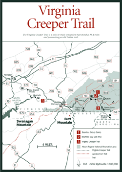
Virginia Creeper Trail [Fig. 49, Fig. 46(49)] The Virginia Creeper Trail is a rails-to-trails conversion that stretches 33.4 miles from Abingdon in Washington County to the North Carolina line in western Grayson County. As with most trails that follow old railroad beds, this one links nature with history as it passes along an old Indian trail through some of southwest Virginia's best countryside and most splendid mountain scenery.
With humor, local folks referred to the mountain train that climbed eastward into the Iron Mountains as the Virginia Creeper, a name taken from the plant that grew abundantly beside the tracks. A steam engine laboring up mountain grades with heavy loads of lumber, iron ore, supplies, and passengers was also a "creeper" in every sense of the word.
Before the rails were laid, Indians followed animal trails out of the Blue Ridge to create a footpath northwestward. The path went through The Breaks of Dickenson County into Kentucky and on to the Big Sandy River and the Ohio River. Daniel Boone also camped along the trail, according to early records. In 1887, when iron mining became profitable, a railroad was constructed along the path from Abingdon east to the southern slope of Whitetop Mountain to bring products from the mountains to market.
By 1918, when lumber had become a more important resource, the line stretched 75 miles to Elkland, North Carolina, and included more than 100 trestles. Villagers out picking blackberries or elderberries along the tracks watched as stacks of red spruce, freshly cut from virgin forests high atop Mount Rogers, rumbled by on flatbed cars. Although beset by flood damage as well as economic problems associated with the Great Depression, a train ran at least weekly until 1976.
Walking the Virginia Creeper Trail confirms what a great idea the first person had who looked at an abandoned railroad and said: "Hiking trail!" Because of the extremely heavy loads hauled by steam engines, railroad beds were constructed with minimal grades. When a railroad bed is converted to a hiking trail, people in average physical condition gain access to beautiful countryside, pristine mountain streams, and exciting mountain passes. Anywhere the nearly extinct "iron horse" once tooted its whistle, there's trail potential.
Between 1800 and 1916, the federal government laid more than 300,000 miles of track. By the 1970s, many railroads were abandoned for other forms of transportation. Since 1986, a nonprofit group called the Rails-to-Trails Conservancy (RTC) has been the largest advocate for converting those tracks to trail systems. Who benefits? Anyone who wants to hike, bike, jog, ride a horse, fish a stream, or watch a bird along green corridors that lead through our country's towns, prairies, pasture lands, river valleys, and mountains.
The trail is wide, smooth, and well kept. Signs are clear and easy to locate at access points. The west half of the trail, from Abingdon to Damascus, is level and mostly open or it skirts the edge of fields and pastures. Signs along the first 1.5 miles provide a guided nature walk. At mile 7.2, the Middle and South forks of the Holston River converge at a trestle. The elevation is 1,900 feet, the lowest on the trail. Then the path climbs through dense forest into Mount Rogers National Recreation Area (NRA), rising 2,000 feet to grassy balds on Whitetop Mountain.
Because the railroad grade was never more than 5 percent, even going uphill is not difficult. Nevertheless, the trail is heavily used by mountain bikers who take a shuttle to the top, then ride downhill to Abingdon. Walkers do well to stay alert for careening bicyclists to come whizzing by.
It's hard to find a bicycle trail more user-friendly than the 18 miles between Whitetop and Damascus. The Creeper Trail combines downhill coasting with spectacular mountain scenery. Rental bikes and skis are available at Abingdon and at Damascus on a seasonal basis. Bikers should ring a bell or toot a horn to alert hikers before passing.
Although no facilities are available on the trail, the many access points and small towns along the way make it easy to walk sections of the trail without carrying gear. Be prepared for sudden changes in weather, especially at higher elevations. Cold wind, rain, fog, or snow can arrive unexpectedly. When temperatures near the freezing mark on a damp day, ice can form in a hurry.
The Virginia Creeper Trail is an excellent place to observe wildlife, especially on weekdays or the off-season when human usage is light. Where the path parallels streams, you may find the chewed stumps that beavers leave where they have felled trees. Near mile 2, look for a beaver lodge in the pond. If there are fresh cuttings about, there's a good chance you could sit very quietly here at dusk or early morning and see the nocturnal rodents at work.
On warm spring evenings, when the temperature rises above 50 degrees, spring peepers (Hyla crucifer)—they're really thumbnail-size frogs—gather in damp areas to chirp their loud mating chorus. The marshy upper end of the pond is a favorite habitat of pond dwellers.
Cottontail rabbits and gray squirrels are abundant along the trail. Larger and somewhat rare fox squirrels inhabit small woodlands, stream corridors, and field borders. Both red and gray foxes are in the area. This is not the best place to find black bear, but visitors may get lucky and spot one. On the other hand, chances are good hikers might round a bend and startle a doe crossing the path with her fawns. Hikers, however, may be the ones to jump if they stop to sip from their canteen and a ruffed grouse or woodcock beside the trail suddenly explodes into flight. On rapid wing beats, ducks are likely to rise ahead from the South Fork of the Holston to settle farther upriver. In fact, one bird watcher estimates as many as 40 different species of birds can be seen per day. Where there are open fields, look for colorful bluebirds, goldfinches, and meadowlarks. In woodlands, the ovenbird, Carolina chickadee, nuthatch, and wood thrush proclaim their territories.
Along the 1.5-mile nature trail on the west end, there are two trees prized for their flexible wood. The Osage orange (Maclure pomifera) takes its name from the Osage Indians, who put the wood's flexibility to use in their bows. The mockernut hickory (Carva tomentosa) has been widely used for wagon parts, tool handles, and barrel hoops. The mockernut's wood will take a great deal of strain before breaking.
A sprinkling of the many wildflowers to look for includes bloodroot (Sanguinaria canadensis), spring beauty (Claytonia virginica), large-flowered bellwort (Uvularia grandiflora), solomon's-seal (Polygonatum biflorum), Virginia dayflower (Commelina virginica), and ditch stonecrop (Penthorum sedoides). Wildflowers bloom late in the spring at higher elevations past Taylors Valley (mile 21).
Impressive stands of Catawba rhododendron (Rhododendron catawbiense) hang out over streambanks in mountainous sections of the trail. A foggy, drippy day along the cascading waters of Whitetop Laurel Creek when the lush, purplish pink flowers are blooming offers a soft beauty for those who enjoy rainy-day hikes. Redbud, dogwood, wild cherry, and shadbush add their fragrance and color to spring on the trail.
At mile 8, the trail passes the north end of South Holston Lake, known for its smallmouth bass. The big reservoir, most of which lies in Tennessee, also provides excellent crappie fishing, along with largemouth bass, channel catfish, flathead catfish, and bluegill. In spring, white bass, and recently, walleye, run out of the lake and up the South Fork of the Holston, which parallels the trail to mile 13. However, access is limited, and visitors must obtain landowner permission if they have to cross private property to reach the water.
East of Damascus, the trail parallels Whitetop Laurel Creek, one of the state's best streams for stocked trout. Above the Straight Branch tributary, Whitetop Laurel is a native trout stream. Special regulations apply. Check the fishing regulations booklet available wherever licenses are sold.
Abingdon (mile 0): Located in center of downtown near corner of A Street SE and Green Springs Road. Turn south off East Main Street onto Pecan Street. Go .2 mile. Look on left for the steam locomotive on permanent display at the trailhead. Parking is on the right.
Alvarado (mile 8.5): Take Exit 19 from I-81, go 5 miles east on US 58, turn right on VA 722 to 710 and parking area.
Damascus (mile 15.5): Trail parallels Main Street (US 58). Parking is where Main Street crosses Beaverdam Creek Bridge. Damascus, once a Daniel Boone campsite, is a nationally recognized welcome center for hikers on the Appalachian Trail (AT) and the Virginia Creeper Trail. An AT hostel is located here.
Creek Junction (mile 25): From Damascus, take US 58 east 10.1 miles to right on gravel VA 728 and go 1.5 miles to parking at trestle.
Whitetop Station (mile 32.3): From Damascus, take US 58 east 17 miles to right on VA 755. Go 2 miles to parking.
[Fig. 49] The Virginia Highlands Arts and Crafts Festival, held in historic Abingdon in Washington County during the first two weeks in August each year, is the town's way of celebrating the revival in old-time arts and crafts. The streets are filled with booths of some of the area's finest artists and craftspeople.
Visitors also browse the colorful shops in a town known for its own mountain crafts. A must-see is the Cave House Craft Shop housed in a 1958 Victorian home at 279 East Main Street, and run by a 140-member cooperative. Visitors can also take in a play at Barter Theater, America's longest-running repertory theater (at the corner of Main and College streets), but they are no longer required to barter corn or sweet potatoes for admission. Cash is accepted. The historic Martha Washington Inn with its wide front porch and famous rocking chairs beckons the weary traveler to come sit and watch the world pass. This elegantly restored inn predates the Civil War, and was once known as Martha Washington College, a school for young women. Typhoid fever and the Great Depression forced the school to close in the early twentieth century.
Read and add comments about this page