 Little
Wilson Creek Wilderness Little
Wilson Creek Wilderness
Little
Wilson Creek Wilderness Little
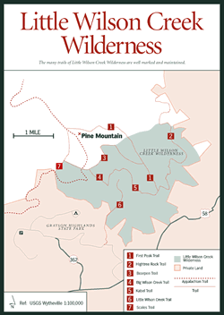
Wilson Creek Wilderness [Fig. 34(15), Fig. 35] In the western end of Grayson County, snugged up against the northeastern border of Grayson Highlands State Park, is Little Wilson Creek Wilderness. Wilson Creek defines the border between the park and the 3,900-acre wilderness.
The first two of three peaks with numbers for names (First Peak, Second Peak, and Third Peak) at the eastern edge of Pine Mountain are at the heart of the wilderness. The highest point of the wilderness is the 4,857-foot summit of Second Peak. Little Wilson Creek, which gave the wilderness area its name, drains the western slopes of all three peaks.
 Unlike
some wilderness trails, the many trails of Little Wilson Creek are well marked
and well maintained. Besides part of the AT, which makes a sweep through the
northwest corner, the First Peak Trail [Fig.
35(1)] and Bearpen Trail [Fig.
35(7)] are most heavily used. Solitude is easier to find on Little Wilson
Creek [Fig.
35(6)], Kabel [Fig.
35(5)], and Hightree Rock [Fig.
35(2)] trails.
Unlike
some wilderness trails, the many trails of Little Wilson Creek are well marked
and well maintained. Besides part of the AT, which makes a sweep through the
northwest corner, the First Peak Trail [Fig.
35(1)] and Bearpen Trail [Fig.
35(7)] are most heavily used. Solitude is easier to find on Little Wilson
Creek [Fig.
35(6)], Kabel [Fig.
35(5)], and Hightree Rock [Fig.
35(2)] trails.
Besides the typical oak-hickory forest, look for Fraser magnolia and yellow birch in moist areas and a spruce-fir forest at higher elevations. Trail features include a grassy bald and an open, rocky meadow (Bearpen Trail), the clear, cold waters of Little Wilson Creek (Little Wilson Creek Trail), and outstanding views (First Peak, Kabel, Big Wilson Creek, and Hightree Rock trails).
Read and add comments about this page