 The
Bartram Trail in North Carolina The
Bartram Trail in North Carolina
The
Bartram Trail in North Carolina The
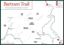
Bartram Trail in North Carolina [Fig. 48, Fig. 49] The North Carolina Bartram Trail serves as a living legacy of the work of William Bartram, a native of Philadelphia who spent much time exploring the southern wilderness. Together with his father, John Bartram, he roamed Florida and the coast of Georgia before venturing off on his own through the Carolinas, Georgia, Alabama, Mississippi, Louisiana, and Florida from 1773 to 1778 (see Naturalists).
An avid writer and illustrator, Bartram kept voluminous journals of his travels and botanical research along the way. In 1791, he published these writings as Travels Through North and South Carolina, Georgia, East and West Florida, capturing his impressions and exacting descriptions of the flora, fauna, and Native Americans encountered. (The Creeks called him Puc Puggy, which translates from the Musko-gean language as "the flower hunter.") More than 200 years later, The Travels, which earned him an international reputation, is still in print and offers rich accounts and passionate passages from a gentle man in love with his work in the natural world.
Following and in places paralleling the route that Bartram took into the southern Appalachian Mountains in 1775, members of the North Carolina Bartram Trail Society, together with the staff of the U.S. Forest Service, have constructed a memorial trail in the Nantahala National Forest. Based on his journals and other accounts, the 75-mile North Carolina Bartram Trail is divided into seven sections, which separately make excellent day hikes or together, a lengthy through-hike. The Bartram Trail also travels into parts of north Georgia and upstate South Carolina.
Members of the North Carolina Bartram Trail Society are active, hard-working volunteers who have spent two decades mapping, building, and regularly maintaining the trail. Walter G. McKelvey of Brevard led the way in the 1970s by securing government approval and support, researching the trail route, encouraging public interest, and directing trail flagging and clearing until his death in 1977. His dream finally came to fruition with the completion of the last segment of the trail in the summer of 1997. In October 1997, the entire trail was designated a National Recreation Trail.
The North Carolina Bartram Trail, which begins on the Georgia/North Carolina border near Georgia's Rabun Bald (4,696 feet), rises steadily as it passes through the forested rim of the Blue Valley and rocky overlooks, through mature oak forests and understory of rhododendron (Rhododendron catawbiense and maximum), mountain laurel (Kalmia latifolia), flame azalea (Rhododendron calendulaceum), and numerous wildflowers on its way across the crest of the Fishhawk Mountains.
Near Otto, the trail drops into the Little Tennessee River Valley, where travelers have a choice of canoeing or hiking an interesting 11-mile trail toward Franklin. From there, a strenuous 12-mile trail segment climbs Trimont Ridge to the highest point on the trail, Wayah Bald, elevation 5,341 feet. Here the yellow rectangular blazes of the Bartram Trail merge for 1.5 miles with the white blazes of the Appalachian Trail (see Wayah Bald). In this more remote section, white-tailed deer (Odocoileus virginia), wild turkey (Meleagris gallopavo), and black bear (Ursus americanus) may be spotted, though the wolves for which the bald is named (Wayah is a Cherokee word for "wolf") have been extirpated. Late-spring and summer birds in this area include the ruffed grouse (Bonasa umbellus), hairy woodpecker (Dendrocopos villosus), veery (Hylocichla fuscenscens), rose-breasted grosbeak (Pheucticus ludovicianus), ovenbird (Seiurus aurocapillus), golden-crowned kinglet (Regulus satrapa), a variety of warblers, and sometimes the yellow-bellied sapsucker (Sphyrapicus varius).
The Bartram Trail works its way down to Nantahala Lake and continues toward Appletree Campground in the Nantahala Gorge. It then ascends and crosses over Rattlesnake Knob where oaks, white pine (Pinus strobus), butternut (Juglans cinerea), and basswood (Tilia americana) form a canopy over wildflowers such as meadow rue (Thalictrum revolutum), Clinton's lily or speckled wood lily (Clintonia umbellulata), Indian pipes (Monotropa uniflora), and shiny patches of galax (Galax aphylla). Eventually the trail reaches the Nantahala River Launch Area before heading up Ledbetter Creek to the mile-high western terminus, Cheoah Bald (5,062 feet). At this point hikers can backtrack or continue north or south on the Appalachian Trail.
Some books still refer to a route that heads into the Snowbird region near Porterfield Gap. This route is now called the "Western Extension" of the North Carolina Bartram Trail, but it is not actively maintained by the society.
Like Bartram himself, the Bartram Trail Society traveled uncharted territory. Armed first with compasses and topographic maps, later with fire rakes, brush axes, and Pulaskis (the ingenious chopping and digging tool invented by U.S. Forest Ranger Edward Pulaski at the turn of the century), volunteers determined the course of the trail. The last section was particularly trying when they ran up against the western wall of the Nantahala Gorge, a near-vertical climb of 1,000 feet. Several scouting trips in 1993 and 1994 ruled out certain routes. According to scouts, the routes would have required nothing less than dynamite, bulldozers, and the state Department of Transportation! In February 1994, however, the dedicated corps bushwhacked, forged, and crawled its way through tangled undergrowth and discovered an old trail that appeared to be the best—and maybe only—way out of the Nantahala Gorge (a trail estimated to have been unwalked for 40 years). It is this kind of dedication, by hundreds of volunteers along dozens of trails in Western North Carolina, that makes it possible for so many to access and appreciate the beauty of the region. In the style of Bartram, these people in love with the natural world document their findings on maps and along trails for all to enjoy.
For more information: The Bartram Trail Society, c/o Dean Zuch, treasurer, PO Box 144, Scaly Mountain, NC 28775. Phone (704) 526-4904. Topographic maps of all seven sections are available for a fee. Or refer to Allen de Hart's book, North Carolina Hiking Trails, third edition.