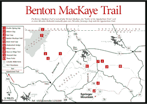
On October 14, 1989, many volunteers, along with a number of U.S. Forest Service employees with whom they had worked jointly on the endeavor, celebrated the opening of the Georgia section of the interesting and diverse Benton MacKaye (pronounced Mac-Eye) Trail (BMT). From its beginning at Springer Mountain, the trail's distance covers 90 miles to US Hwy 64 in Tennessee. The trail should eventually wind through Tennessee and North Carolina, forming a 250-mile loop with the Appalachian Trail and providing an alternative long-distance footpath in the Southeast.
Named for Benton MacKaye, the "Father of the Appalachian Trail" (see Appalachian Trail), this trail grew out of the need to develop an alternative to the popular Appalachian Trail and also to develop a trail that more closely adhered to MacKaye's original trail plan—a plan that envisioned a path reaching to the Cohuttas in the north central portion of Georgia.
Volunteers have already documented much of the variety along the trail. Two beautiful waterfalls, Long Creek Falls and Fall Branch Falls, are scenic attractions. Atop Rhodes Mountain in the winter, one is afforded a 360-degree view of the surrounding countryside. A striking man-made attraction is the suspension bridge across the beautiful Toccoa River. The terrain varies from laurel- and rhododendron-covered walks along creeks to timbered land to ridgetop pathways to walks through thick forests. There are areas with quick access to major highways through Georgia, as well as quite remote areas within and south of the Cohutta Wilderness as well as in the Big Frog Wilderness. There is a 26-mile stretch of trail with only two road crossings.
 The
BMT is blazed with an off-white diamond symbol. The blazes are located at intervals
of approximately 200 feet. There may be other blazes present, such as the white,
vertical, 2-by-6-inch stripe of the AT or the 2-by-6-inch, vertical, blue blaze
of the Duncan Ridge Trail. These blazes are present only along the first 20
miles of the BMT and will not be seen west of Rhodes Mountain. See below for
other trail blazes in the Rich Mountain area and in the Cohutta Wilderness area.
The
BMT is blazed with an off-white diamond symbol. The blazes are located at intervals
of approximately 200 feet. There may be other blazes present, such as the white,
vertical, 2-by-6-inch stripe of the AT or the 2-by-6-inch, vertical, blue blaze
of the Duncan Ridge Trail. These blazes are present only along the first 20
miles of the BMT and will not be seen west of Rhodes Mountain. See below for
other trail blazes in the Rich Mountain area and in the Cohutta Wilderness area.
SECTION 1: SPRINGER MOUNTAIN TO THREE FORKS. Fig. 56(10)] 5.8 miles. Easy. This section essentially traverses the pre-1977 corridor of the AT. It is well constructed and well blazed. Access roads are FS 42 and FS 58 (Noontootla Creek Road).
SECTION 2: THREE FORKS TO GA 60. [Fig. 56(10)] 11.4 miles. Moderate. This section is contiguous in part with the AT and entirely with the Duncan Ridge Trail. It is essentially an overnight hike. Highlights of this section are the dramatic Forest Service suspension bridge over the Toccoa River and the newly created wildlife opening where many animals and plants may be readily seen. Access roads are FS 58 and GA 60.
SECTION 3: GA 60 TO SKEENAH GAP. [Fig. 56(9)] 5.7 miles. Difficult. This section is the most strenuous part of the BMT. The view from the top, however, after the character-building climb up the south face of Wallhalah Mountain, is worth the effort. Note that at Rhodes Mountain the Duncan Ridge Trail turns east-northeast, while the Benton MacKaye Trail regains its own identity and proceeds westward. Access roads are GA 60 and Skeenah Gap Road.
SECTION 4: SKEENAH GAP TO WILSCOT GAP. [Fig. 56(7,9)] 5.3 miles. Moderate. An up-and-down hike through general forest area. This is a very nice day hike, especially in winter, with views of the adjacent ridges and pastoral valleys. Access roads are Skeenah Gap Road and GA 60 at Wilscot Gap.
SECTION 5: WILSCOT GAP TO SHALLOWFORD BRIDGE. [Fig. 56(6,7)] 7.1 miles. Moderate. The most difficult part of this hike is the initial climb up Tipton Mountain. After this portion, the trail undulates over Brawley Mountain and Garland Mountain before descending to the beautiful Toccoa River. The climbs are challenging, and the beauty of the forest is rewarding. Access is by GA 60 and adjacent Forest Service roads, Dial Road and Aska Road. The number of access points allows for shorter hikes if desired.
SECTION 6: SHALLOWFORD BRIDGE TO GA 5. [Fig. 56(6)] 11.4 miles. Moderate. This is an obvious overnight trek, but it may be shortened to a very pleasant day hike by skipping 3.2 miles of road walk on the eastern end and 1.6 miles of road walk on the western end, taking only the 6.6-mile trail from Fall Branch to Laurel Creek. This section provides many sites atop Rocky and/or Davenport mountains or Scroggin Knob to stop, rest, and enjoy the views. Fall Branch Falls is a highlight right at the start, and the view from Scroggin Knob near the end of the hike is also pleasurable. It is here, climbing Rocky Mountain, that the BMT begins to follow the western arm of the Blue Ridge. White square blazes designating the contiguous Rich Mountain Trail will also be seen here. Access to the forested portion is via Stanley Gap Road, 3.2 miles west of where it and Aska Road intersect, and the Weaver Creek Road at its southwest end at the USFS boundary line.
 SECTION
7: GA 5 TO BUSH HEAD GAP. [Fig.
56(5)] 6.5 miles. Easy. First part of this section uses an easement on private
property. Hikers will encounter superb spring wildflowers and a picturesque
creek with picnic table. This section also contains the only shelter on the
BMT. The remaining 2.5 miles are on Gilmer County roads to Bush Head Gap.
SECTION
7: GA 5 TO BUSH HEAD GAP. [Fig.
56(5)] 6.5 miles. Easy. First part of this section uses an easement on private
property. Hikers will encounter superb spring wildflowers and a picturesque
creek with picnic table. This section also contains the only shelter on the
BMT. The remaining 2.5 miles are on Gilmer County roads to Bush Head Gap.
SECTION 8: BUSH HEAD GAP TO DYER GAP. [Fig. 56(3,5)] 12.6 miles. Moderate. A long day hike or a very pleasant overnight trip, this part of the BMT is located entirely along the Tennessee Valley Divide. This is general forest land and many activities of the multiuse forest, such as logging, will be seen here. Road access is by the Bush Head Gap Road and FS 64 south of Watson Gap at the northern end.
SECTION 9: DYER GAP TO WATSON GAP. [Fig. 56(3,10)] 4.5 miles. Easy. A very short segment of the BMT, this footpath traverses riverside forest timber management activity areas, and then climbs a mountain with views of the Cohutta Wilderness before returning to the trailhead. Road access is by FS 64 at Dyer Gap and the old GA 2 at Watson Gap.
SECTION 10: WATSON GAP TO DOUBLE SPRING GAP. [Fig. 56(1,2)] 8.5 miles. Moderate. This section along the high ridge is located primarily within the Cohutta Wilderness boundary. It is minimally blazed and semiprimitive in construction. The BMT is contiguous with the Hemptop Trail north of Dally Gap. The blazing changes once again, but the former Forest Service road provides an easily followed path. Road access is at Watson Gap. Double Spring Gap is at the Georgia/Tennessee state line in the middle of the wilderness. A trail here leads north.
SECTION 11. DOUBLE SPRING GAP TO THUNDER ROCK CAMPGROUND. 11.2 miles. Strenuous. This newly opened section leads to the Ocoee River in Tennessee and lies primarily within the Big Frog Wilderness. Trail ascends Big Frog Mountain, a very steep climb, then descends on a network of old trails and Forest Service roads, along with the new trail, before reaching Thunder Rock Campground in the Cherokee National Forest and Ocoee #3 powerhouse on US 64. The 1996 Summer Olympic venue for whitewater events is just east on the Ocoee River.
Read and add comments about this page