 The
Rich Mountains The
Rich Mountains
The
Rich Mountains The
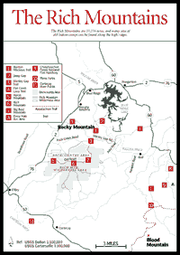
Rich Mountains The 13,276-acre Rich Mountains [Fig. 18] are primarily wilderness (9,649 acres) and primitive backcountry (3,627 acres) that is not heavily used. The Rich Mountains are remarkable because many of the peaks and ridges are covered with a deep, black porter's loam, a characteristic these mountains share with the Cohuttas. In the Eastern Blue Ridge, such soils are confined to coves.
On the Rich Mountains, this soil covering results in spectacular wildflower displays. On ridges and slopes alike, one finds lush summer herb growth and forests of basswood, ash, and black cherry—trees that occur in the Eastern Blue Ridge mostly in high rich coves. Gaps—at least in the Turniptown area—have populations of the rare columbo, a most unusual plant. There is old growth timber south of Turniptown Mountain. North-facing coves have boulderfields and rare northern wildflowers at the southern limit of their range. There is a large bear population, and one can find "licks" where deer have eaten clay-rich soil.
About 60 inches of rain fall here each year, May usually being the wettest month and April and July the driest.
Sites of old Indian camps can be found along the high ridgelines. Remnants of white settlements dating from about 1910 are just north of this range's namesake peak, Rich Mountain [Fig. 18(6)]. The largest gold nugget ever found in Georgia came from a creek draining this area. Marble, which is mined at the famous quarries near Tate and Marble Hill, can also be found exposed in the bottom of the Murphy Syncline (see below).
Elevation varies from approximately 2,000 feet near Little Rock Creek to 4,081 feet on Big Bald Mountain [Fig. 18(7)]. High peaks and lookouts from the Old Road offer panoramic vistas after leaves fall. Rugged mountain terrain with rock outcrops and streams with many small waterfalls create a beautiful scenery.
US 76 between Ellijay and Blue Ridge, Georgia, generally follows the Murphy Syncline, which divides the highly metamorphosed rocks of the Blue Ridge proper from the moderately metamorphosed rocks of the Cohuttas.
This remarkable geologic trough is clearly visible in satellite photographs. It is likely, though, that the uninformed visitor driving up US 76 in the deep gash of the Murphy Syncline would pass the Rich Mountains area by, since the higher peaks and ridges are barely visible from the road. Hikers exploring the Rich Mountains area should be experienced and carry topographical maps, compass, and other survival gear.
 Aska
Trails Area. This area contains a 17-mile hiking and mountain biking trail
system located on national forest land near Deep Gap and Stanley Gap south of
Blue Ridge and east of Ellijay. Trails ascend to near 3,200 feet, providing
vistas of mountain ridges, and descend to the shores of beautiful Lake Blue
Ridge. They also pass through coves of mature hardwoods as well as traversing
thickets of laurel and rhododendron.
Aska
Trails Area. This area contains a 17-mile hiking and mountain biking trail
system located on national forest land near Deep Gap and Stanley Gap south of
Blue Ridge and east of Ellijay. Trails ascend to near 3,200 feet, providing
vistas of mountain ridges, and descend to the shores of beautiful Lake Blue
Ridge. They also pass through coves of mature hardwoods as well as traversing
thickets of laurel and rhododendron.
[Fig. 18(3)] This trail offers a moderately strenuous 5-mile hike (one-way) or a difficult 12-mile bike ride (including the mileage along the roads to return to the trailhead) through a typical southern Appalachian hardwood forest with a variety of trees, shrubs, and wildflowers unmatched in their diversity throughout the country. Views of surrounding mountains, especially in winter on the overview of Lake Blue Ridge, add to the outdoor experience.
The trail begins at the corner of the parking lot at Deep Gap and starts as a gradual climb toward the summit of Davenport Mountain. There are several short, relatively steep ascents, but they are not strenuous. The trail along the south side of Davenport Mountain provides an overview of the mountains to the south and west. From the top of Rocky Mountain, the trail descends for 2.9 miles to Stanley Gap.
For the mountain biker, this is one of the most difficult bike rides in the area, but an incredible view greets you at the top, particularly in the winter and spring when there are fewer leaves. Once you descend to Stanley Gap, make a left off Stanley Creek for 2 miles, make a left on Aska Road, ride for 2.5 miles, and you are back at your car.
It's always important when you ride—particularly on a remote trail like this one—that you ride with someone and let someone know where you are going and when you expect to be back. In addition, the mountain biker survival motto is "always eat before you're hungry and drink before you're thirsty." Less-experienced riders on this trail especially should heed this bit of advice.
[Fig. 18] This 3.3-mile trail offers a very pleasant hike or bicycle ride, first overlooking and then alongside the shoreline of Lake Blue Ridge. The forest type is basic southern Appalachian hardwood with a variety of trees, shrubs, and wildflowers. Forest animals are rarely seen, but include deer and turkey. The trail begins on the east side of Aska Road at Deep Gap and starts as a gradual climb toward the summit of Green Mountain. On the trail there are five short, relatively steep ascents, but they are not strenuous. The ridge atop Green Mountain provides an overview of Charlie's Cove of Lake Blue Ridge. The trail then descends for 2.4 miles to its terminus on FS 711. Views of Lake Blue Ridge are found almost the entire way after cresting the mountaintop.
[Fig. 18(4)] This 5.8-mile, moderately difficult loop trail provides a range of forested settings as well as a short segment along a mountain creek. Beginning at Deep Gap on Aska Road, follow the white and dark green blazes west from the bulletin board at the parking lot. Within 100 yards the trail forks—bear left on the roadbed. At about .4 mile, take the side trail with the dark green blaze into the woods on the left. This trail goes through woods for about .25 mile. The trail follows an old logging roadbed before it rejoins a dug trail and gradually descends toward Flat Creek. After .5 mile, the trail joins an old road near the creek. Follow the road downhill to the creek, cross the creek, and go right at about 50 yards on an old road. Follow the road about 1 mile to the head of a valley with mature hardwoods in abundance. Cross the creek, again heading uphill, and gradually ascend to a gravel road. Follow the gravel road with the dark green blaze 2 miles back to the parking lot.
[Fig. 18(5)] This mountain has a rounded dome covered with rich, black soil and a wildflower display in spring. An old timber growth (129 years) lies on the south face of Aaron Mountain. At Horse Cove, there is a good boulderfield and a northern hardwood forest with some possibly record-sized, second-growth trees, especially silverbell.
The Red & White and River Loop trails are sister trails located in the Cartecay Tract of the Rich Mountain Wildlife Management Area off Highway 52 East. The Red & White is a 2.6-mile, beginner/intermediate trail closest to the entrance of the management area. This trail is a single-track loop with occasional rocky or rooty sections. Dogwoods line this trail and brighten the trail in the spring. Be prepared for a long climb near the end of the trail. If you're looking for a short, relative easy ride, be careful not to turn on the River Loop or you might be out longer than you planned.
The River Loop is a 3.4-mile, intermediate/advanced trail just below the Red & White that follows the Cartecay River in sections. The single track is tight in spots, a few rocky descents challenge even the bravest riders to walk, a sand trap swallows your tires near the river, and an occasional windblown tree clutters the trail. Once you conquer the steep downhill, you can cool down with a dip in the Cartecay River or nap in the sun on the rocks. This is a beautiful ride, and it can easily be coupled with a ride on the Red & White or other trails in the area to make a full day of riding.
The Owltown Creek Trail is the access point for the Owltown Mountain Trail, and, while only 4 miles long, the loop offers something for riders at every skill level: tight, rocky single track; a few creek crossings; some steep descents and ascents; grassy, double track; and a gravel road. The Ellijay Chapter of SORBA (Southern Off-Road Bicycle Association) and the Cartecay River Bike Shop, the bike shop in the area, hold beginner/intermediate bike clinics on this trail. True beginners might want to start the ride at the lower end of the trail where it crosses the bridge on Owltown Creek.
LAKE BLUE RIDGE. [Fig. 18] The lake shimmers like a sapphire in a green granite setting. Most of the surrounding land is part of the Chattahoochee National Forest, which protects the lake from being overly developed. Except for a few water skiers, most of the visitors come to camp and fish. Although the prime fishing attractions are walleye, bluegill, and smallmouth bass, this is the only lake in the state where one can battle the mighty muskie, a large game fish of the pike family. ***View a reader's comment about the muskie. Thirty-five fish attractors—man-made feeding covers—have been scattered around the coves and creeks. Lake Blue Ridge is fed by the north-flowing Toccoa River. The river flows gently for about 15 miles north of the dam, then changes its name to the Ocoee and froths into one of the Southeast's most exhilarating whitewater streams for rafting and kayaking.
LAKE BLUE RIDGE TRAIL. .6 mile. A loop trail that follows the shoreline of Lake Blue Ridge and offers a beautiful view of the lake.
LAKE BLUE RIDGE CAMPSITES. 55 campsites in the area, several along the lake; bathrooms and showers; no hookups provided. For availability around the lake Memorial Day through Labor Day, contact the U.S. Forest Service, Toccoa Ranger District (see address above). Phone (706) 632-3031.
LAKE BLUE RIDGE BOAT RENTAL. Fishing boats can be rented at the Blue Ridge Lake Marina, phone (706) 632-2618, on the northern side, near the dam. It is the only commercial outlet on the lake for gas, food, and supplies. It also provides one of several boat launch ramps. Others are at Morganton Point and the more remote Lake Blue Ridge Recreation Area (also known as Dry Branch or Green Creek). The U.S. Forest Service offers tent camping and picnic areas at both sites, phone (706) 632-3031. For additional information, contact the Fannin County Chamber of Commerce, PO Box 875, Blue Ridge, GA 30513. Phone (706) 632-5680.
Located on the shores of Lake Blue Ridge .5 mile from the town of Morganton, this campground contains 37 campsites, 8 picnic sites, a designated swimming area with a lifeguard on duty during the summer camping season, and a boat launch ramp. No showers or hiking trails are located within this recreation area, and electricity is available only in the bathrooms.
ASKA ROAD TO NEWPORT ROAD. Starting from the intersection of old US 76 and Aska Road, go south 13.8 miles. Turn left at the dead end onto a paved road to Dial, Georgia. This road comes out on GA 60, where one can head for either Dahlonega or Morganton. For a picture-postcard alternative, turn right at the dead end onto Newport Road and go 4.5 miles to SR 1010. Turn right and go 12.2 miles to Cartecay.
BOARDTOWN ROAD BETWEEN ELLIJAY AND BLUE RIDGE. This 18.6-mile drive between Ellijay and Blue Ridge provides a good look at the intimacy and charm of the north Georgia countryside. Visitors will pass red barns and silver silos, small green fields with silver creeks running through them and cows wandering about, Christmas tree farms, double-wides, and cedar homes. Pickup truck drivers will lift an index finger off the steering wheel to say "howdy" as they pass.
[Fig. 18(11)] The Cartecay is a small, intimate river located east of Ellijay. Flowing out of a long valley and past farmlands, it passes over a series of tight drops around upland ridges. It then returns to its more placid nature just prior to its confluence with the Ellijay River, where the two become the Coosawattee. The Cartecay is a narrow, clear mountain stream with almost continuous Class I and II rapids for the first 5.5 miles of this section. Although level, it is fast flowing along steep ridges and through shaded tree canopies for the final 6 miles. This is intermediate to advanced whitewater with one unavoidable Class III rapid. The river requires more skill than the upper Chattahoochee and Broad rivers. In places it is comparable to Section III of the Chattooga.
Map References: For Cohuttas and Rich Mt., USGS 1:24,000 series: Cashes Valley–Blue Ridge–Wilscot–Ellijay–Tickanetley–Noontootla. County Highway Maps: Gilmer–Murray–Fannin–Gordon.
Read and add comments about this page