 White
Oak Stamp
  White
Oak Stamp
 White Oak Stamp, together with Buck Creek and Chunky Gal Mountain, is so unusual that parts of this area are classified and protected as "special interest areas" by the U.S. Forest Service. White Oak Stamp and adjacent areas of Chunky Gal and the Buck Creek watershed offer not only one of the very best examples of old growth, high-altitude forest areas to explore, but also vistas as exciting as any area within the scope of this book.
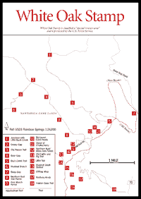
It is rare to find a large "flat" area such as White Oak Stamp at high elevations along the Blue Ridge. Most of the forest above 4,200 feet at White Oak Stanp is virgin old growth. A good part of it, especially on slopes and ridges, is high-altitude northern red oak forest [Fig. 32(8)], with many trees exceeding 2 feet in diameter. Shrubs here include flame azalea, several viburnums, and three species of blueberry. Mixed northern red oak–white oak forest occurs in certain areas [Fig. 32(12)]. Perhaps the most exciting environment is the area of northern hardwoods, especially in the Big Laurel cove heads [Fig. 32(10)], through which the Buck Creek Trail [Fig. 32(5)] passes. Here are giant, old, yellow birch between 2 and 3 feet in diameter. Subdominants are buckeye and beech, the latter predominating on slight ridges with a rare pure beech forest lower down [Fig. 32(9)]. Just above it is a large stand of rare chokecherry [Fig. 32(11)].
The trail bisects one of the strikingly beautiful gneissic boulderfields. The northern herb-wildflower display is outstanding, with perhaps the largest colonies of the edible ramp and the poisonous large hellebore that visitors will ever see. This forest continues on the east side of Chunky Gal as far as Bear Gap [Fig. 32(4)].
 In
a low area not far from the Appalachian Trail—the old trail, now rerouted—lies
a remarkable high-altitude heath bog on the head of Muskrat Branch [Fig.
32(6)]. While the dominant shrubs are rosebay rhododendron and mountain
laurel, purple rhododendron does occur. This thicket is difficult to penetrate,
but bears love it and native brook trout are common in the tiny, crystal-clear
streams. Yellow birch, hemlock, and red maple make up a scattered overstory.
The rare bog turtle may be present. Two small areas are open sedge marshes with
cinnamon fern. Approaching the bog from the north is an old "burl road"
formerly used to haul out rhododendron root burls. These burls were used in
the manufacture of pipe bowls when supplies from the Mediterranean were cut
off during World War II.
There is a spring at the Muskrat Creek shelter [Fig. 32(15)] on the Appalachian Trail. Not far south of it are two cliff-top vistas (no trails) that overlook the Tallulah watershed.
Hikers who walk west on the ridge opposite the shelter and are able to find the old cattle and pig trail [Fig. 32(13)] can follow it down, around, and north of a little top [Fig. 32(14)], then back out southeastward to the top of Raven Rock Cliff, which has fine vistas.
Map References: USGS 1:24,000 series: Rainbow Springs.
Read and add comments about this page