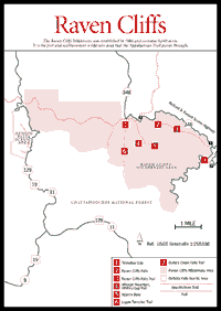
Established in 1986, the Raven Cliffs Wilderness Area is located northwest of Cleveland, Georgia. A number of trails with beautiful mountain streams and waterfalls, mountaintops, a wide variety of natural community types, rock outcrops, and scenic vistas abound throughout the 9,115-acre area.
[Fig. 27(8)] Smithgall Woods Conservation Area was acquired by the state in 1994 as a gift-purchase from Charles A. Smithgall Jr. Governor Zell Miller dedicated the 5,562-acre area as a Heritage Preserve, ensuring that this spectacular, pristine area will remain protected for future generations. Duke's Creek runs through the property and is available for catch-and-release fishing with special regulations.
To observe hardwoods, streams, and wildlife, hikers can explore the area on trails and bikers can explore the area on roads. As we go to press, two hiking trails have been constructed, and a third is under construction. The Laurel Ridge Interpretive Trail is a moderately strenuous, 1.5-mile loop. The Cathy Ellis Memorial Trail is an easy, 1-mile walk. The Martin's Mine Historic Trail, which is under construction, will allow the hiker to see the site of the 1893 gold mine, where miners dug vertical shafts as deep as 125 feet and a tunnel 900 feet long to locate and follow the gold-bearing quartz vein. The Smithgall Woods Conservation Center also provides accommodations for executive and organizational conferences and getaways.
[Fig. 26(7)] About 1 mile, marked with blue blazes. The trail is the roadbed of the Byrd-Matthews Lumber Company logging railroad, operated circa 1914–15. The large falls seen from the trail and parking lot is called Duke's Creek Falls even though it is on Davis Creek. There are several smaller waterfalls in the area. The trail ends at the confluence of Davis Creek and Duke's Creek. Duke's Creek is a beautiful mountain waterway with large boulders and splashing water around foaming pools and riffles. Spray from the falls, which is about 250 feet high, cools the area and provides relief for the hiker.
Careful observers will notice the small wildflowers growing along the banks of the trail. Water seeps out of this bank at scattered locations and, with broken patches of sunlight, provides excellent habitat for a variety of flora. This is a west-facing slope with patches of mountain laurel and rhododendron all along the way. The upper part of the slope is drier, with mixed hardwoods, especially oaks, hickories, and tulip poplars, forming a tree canopy about 50 feet high. Toward the bottom of the trail and along Duke's Creek, a cove forest of young hemlock and white pine is developing. Several large hemlocks provide an accent along the stream bank.
[Fig. 26(3)] About 2.5 miles, easy to moderately difficult. This trail, like the Duke's Creek Falls Trail, is the roadbed of the Byrd-Matthews Lumber Company logging railroad, operated circa 1914–15. Dodd's Creek is one of the most beautiful mountain streams easily accessible in north Georgia. It splashes and winds through the mountain valley with an abundance of whitewater, riffles and pools, moss-covered seepages, and overhanging tangles of laurel. At numerous points along the trail, the hiker can approach the stream for a closer view. There are five or six lesser falls to observe along the way, and one of these is impressive enough to make many visitors think it is Raven Cliffs Falls itself.
Near the falls the trail climbs about 40 feet and moves a little away from Dodd's Creek, then returns at Raven Cliffs. Directly ahead, the visitor encounters a massive cliff face of solid rock that rises vertically from the landscape about 80 to 90 feet. The cliff appears from the trail as two large blocks with a narrow crevasse between. Raven Cliffs Falls results from the water of Dodd's Creek falling straight down between the blocks back inside the crevasse and into a dark pool at the bottom. Although the water flow is not great this high in the drainage basin, the sound of it is amplified by the cliff face and gives the visitor an overall impression of the powerful forces at work sculpting the mountain landscape.
Even though no signs identify the trail, it is a heavily visited area. On a November weekend, for example, 42 vehicles were parked at the trailhead and six camps were in use nearby. At Raven Cliffs, two mountain climbers were rappelling from the cliff face, and several hikers were sitting on top of the cliff. In spite of such a level of activity, this is one of the best trails anywhere for a great hiking experience with the whole family.
 Wildcat
Mountain, Whitley Gap Trail
Wildcat
Mountain, Whitley Gap Trail [Fig. 26(4)] Whitley Gap Trail is about 1.1 miles long; if the visitor wants to visit Adams Bald [Fig. 26(5)], another .5 mile is added to the trip. The best part of the trail, however, is to the top of Wildcat Mountain, which is only about .5 mile. The climb up the north slope is about 300 feet. This trail is fun for children and adults alike. It ascends from the road first through a stand of sweet birch and some hardwoods, and then through a laurel thicket of rhododendron and mountain laurel. This type of heath growth is typical on the north-facing slopes of higher peaks in this area.
Whitley Gap Trail is an easily accessible example of this fairyland growth form. Children are amazed by this natural community type. Everything is their size and everything is green and pretty. There are moss-covered rocks, ferns, and wildflowers along the trail. Small, gnarled limbs of the laurel thicket arch over the path, making it a secret passageway. The trail emerges from the evergreen thicket near the ridgetop of Wildcat Mountain at an elevation just under 3,800 feet. This is the highest peak in the vicinity, and it provides an outstanding scenic view in all directions, especially west and south. The fairyland theme continues on the Wildcat Mountain ridgeline. White oaks, chestnut oaks, scarlet oaks, and several sweet birch, which normally grow into tall dominant trees, are gnarled and stunted on the mountaintop. Limbs start about 2 feet from the ground, and children can't resist climbing them to get an adult's view of the surrounding mountain ranges.
[Fig. 26(6)] About 2 miles, blue blazes. The Logan Turnpike is an abandoned toll road that was privately maintained and used during horse-and-buggy days as a corridor through the mountains. It is difficult to imagine anyone pulling an empty wagon, much less a fully loaded one, straight up this steep trail through Tesnatee Gap [Fig. 26(1)]. About .2 mile down the trail and near the bottom of the steep part of the slope, one of the most interesting aspects of this trail begins to appear. Here is an excellent location to observe firsthand the formation of a natural stream in the forest. Tiny springs of water begin to appear along the lower slopes to the right and left of Logan Turnpike. Crystal-clear water seeps up from points along the ground and flows so gently that it does not push aside the leaf litter to make a visible path. These small trickles would go unnoticed in the woods, except that several coalesce and travel along the trail underfoot.
Eventually, the small trickles join others, making small but noisy brooks less than a foot wide. Several of these turn and run along the trail before crossing it to the west side and forming the beginning of Town Creek. The beautiful stream which results contains clear, cold water with moss-covered rocks through the stream bed and no silt to be found. Contrast this with a stream in an urban/suburban community where after a rain, the warm muddy water rushes along gullies from the roadside and fills the streams first with a torrent of erosive force and then with mud and silt as the storm water subsides. The trail extends about 2 miles almost due south from the trailhead and drops about 1,270 feet in that distance—700 feet in the first .5-mile, a part of the trail that is steep and rocky.
[Fig. 26] This scenic route crosses the Blue Ridge and provides scenic overlooks. It forms the northern boundary of the eastern half of the Raven Cliffs Wilderness, giving access to Raven Cliffs's trails, Duke's Creek Falls, and the Appalachian Trail at two places. To arrive at the start of the driving tour, take GA 356 (75 Alternate) out of Helen 2.3 miles. Watch for GA 348 turning west where it dead-ends into GA 356. Set the odometer on 0. The first overlook is at 1.4 miles. The entrance to Duke's Creek Falls parking is .8 mile farther, and the trail to Raven Cliffs about a mile beyond that. One encounters white pines about mile 2.4; the tree is common until mile 4.7, when deciduous (oak-hickory) forest continues to Tesnatee Gap. The road begins to climb steeply at 3.2 miles.
The Tray Mountain vista is to the right at 4.1 miles. The foreground ridge bears white pine mixed with hardwoods, while red maples grow close below the parking area. At mile 4.2 the road bank has a remarkable covering of Christmas fern and primitive club moss. Vistas to the left, such as at miles 5.1, 6, and 6.7, overlook the Raven Cliffs Wilderness. One is able to gaze across the flat Dahlonega Gold Belt to Yonah Mountain and the distant Piedmont. At milepost 6 one begins to see in the road cuts the structure of the most common rock of the Eastern Blue Ridge, banded gneiss. This rock becomes more noticeable at mile 6.3 and at Hogpen Gap, just beyond the crossing of the Appalachian Trail. Here, at 7 miles, the large cut on the left offers a study in the wavy banding of dark and light that characterizes metamorphic rock.
Starting down the colder north slope of the Blue Ridge, there is parking at 7.5 miles and close access to the Appalachian Trail at Tesnatee Gap [Fig. 26(1)]. At this point one crosses the old Logan Turnpike, which came through Tesnatee Gap, one of the earliest crossings of the Blue Ridge by the early settlers. From this point the highway parallels the old Logan Turnpike, descending rapidly down the Nottely River headwaters—in this case, Lordamercy Cove. At 8.9 miles one encounters a hemlock-heath community along the creek, and at 9.4 miles in the floodplain south of the highway is a white pine–tulip poplar forest indicating the site of an abandoned field.
One should anticipate a settlement ahead, and after passing through a mix of white pine and Virginia pine, one reaches the first house at 10.5 miles. At mile 10.8, by looking across the floodplain, one can see the extent of former hillside pastures so common in the early days of settlement. Note how the growth of white pines in the old pasture is sharply delineated from the hardwoods above it. Highway 348 dead-ends into GA 180 at 13.6 miles. Turn east on GA 180.
In about 4 miles, the road enters the ring of ultrabasic rock surrounding Brasstown Bald, rock in which Indian carvings are preserved at Trackrock Gap nearby. Continue and cross Jack's Gap, where the Jack's Gap Trail crosses and the road to Brasstown, begins its very steep ascent. Dropping down the east side from the gap, one descends Soapstone Creek, leaving the soapstone and other peculiar rocks at the Owl Creek road turnoff. Continue on and turn south onto GA 75. Almost immediately, the High Shoals Falls Scenic Area road turns east, and in another mile the very steep road to Indian Grave Gap and Tray Mountain (FS 283) also turns east. Continuing on GA 75, one reaches Unicoi Gap in approximately 3 more miles. Unicoi Gap was the boundary between Indian and white lands until the Dahlonega gold rush. It was one of the first gaps crossed by a highway. Continuing down the south side of the Blue Ridge, watch for the sign marking Andrews Cove on the left. Here Andrews Creek follows the westernmost part of the famed geologic anomaly, the Warwoman Shear, which cuts across Lake Burton to the Chattooga River country. Past Andrews Cove, GA 75 descends to the Chattahoochee headwaters and the starting point at Helen.
Map References: USGS 1:24,000 series: Cowrock–Neel's Gap.
Read and add comments about this page