 The
Ellicott Rock Wilderness The
Ellicott Rock Wilderness
The
Ellicott Rock Wilderness The
Ellicott Rock Wilderness This is a 8,274-acre tract of unspoiled mountain land that surrounds the point at which Georgia, North Carolina, and South Carolina come together. The first boundary, a small scenic area, was identified and established in 1966. It and a much larger area were made a part of the National Wilderness System in 1975 and thus became fully protected by guidelines of the 1964 National Wilderness Protection Act.
This primitive land is isolated and well protected, allowing a wilderness experience within its rocky, mountainous terrain.
The National Wild and Scenic Chattooga River flows through the wilderness, cascading from 2,381 feet to 2,100 feet within its boundaries. Fork Mountain, 3,294 feet above sea level, is the second-highest point in South Carolina.
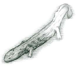
This wilderness has several unique plant communities, a number of rare and endangered plants growing alongside the trails, evergreen forests with dense understory of mountain laurel, streamside rhododendron which defies human penetration, a diverse population of large and small animal life, and many fish, including the eastern brook trout.
Hiking is the only method available for exploring the interior of Ellicott Rock Wilderness. The automobile-access roads merely provide a way to get to the trailheads. No horses, bicycles, or motorized vehicles are permitted. Camping is allowed within the wilderness, but campsites must be over .25 mile from an approach road and 50 feet from a stream or maintained trail.
The Forest Service has recommended a 2,000-acre addition to this wilderness in the Sumter National Forest in South Carolina. The addition would be bounded by SR 107 on the east and the New Burrell's Ford Road on the south.
 CHATTOOGA
RIVER TRAIL. [Fig.
43(1), Fig.
48(7)] This portion of the Chattooga River Trail within the wilderness is
over 3.4 miles of old Indian trail. It runs beside the east bank of the Chattooga
River from a Burrell's Ford trailhead near the river to an intersection with
the East Fork Trail (1.5 miles), then to Ellicott Rock (1.6 miles) [Fig.
48(5), Fig. 50(9)]
to join Bad Creek Trail [Fig.
48(3), Fig. 50(7)]
and Ellicott Rock Trail [Fig.
48(1), Fig. 50(5)]
(.3 mile). The trail is a moderately easy climb through patches of rhododendron
and old growth stands of hemlock, white pine, and mixed hardwood. Bad Creek
is easily crossed during low water but may have to be waded when water is high.
CHATTOOGA
RIVER TRAIL. [Fig.
43(1), Fig.
48(7)] This portion of the Chattooga River Trail within the wilderness is
over 3.4 miles of old Indian trail. It runs beside the east bank of the Chattooga
River from a Burrell's Ford trailhead near the river to an intersection with
the East Fork Trail (1.5 miles), then to Ellicott Rock (1.6 miles) [Fig.
48(5), Fig. 50(9)]
to join Bad Creek Trail [Fig.
48(3), Fig. 50(7)]
and Ellicott Rock Trail [Fig.
48(1), Fig. 50(5)]
(.3 mile). The trail is a moderately easy climb through patches of rhododendron
and old growth stands of hemlock, white pine, and mixed hardwood. Bad Creek
is easily crossed during low water but may have to be waded when water is high.
ELLICOTT ROCK TRAIL. [Fig. 48(5), Fig. 50(9)] See trail information in the Highlands section, (p. 217).
BAD CREEK TRAIL. [Fig. 48(3), Fig. 50(7)] See trail information in Highlands section (p. 217).
SLOAN BRIDGE TRAIL. [Fig. 48(4), Fig. 50(8)] This is a moderately difficult trail in good condition. From Sloan Bridge Picnic Area [Fig. 48(6), Fig. 50(10)], it joins Bad Creek Trail (6.3 miles), then proceeds to Ellicott Rock (1.4 miles). Sloan Bridge Trail is perhaps best used for overnight camping after leaving a car at some other trailhead, such as the Walhalla Fish Hatchery [Fig. 48(10)].
Also called Fork Mountain Trail, it crosses SC 107 and approaches the wilderness from the east. The trail ascends and descends, steeply at times. It climbs to near the top of Fork Mountain and falls to streamside, where it passes opulent woodland flora. Ornithologists find the trail of interest because of the diverse species of bird life related to altitude and flora. Hawks and eagles are often seen in this most remote area of the wilderness.
EAST FORK TRAIL. [Fig. 48(9)] Sometimes called the Fish Hatchery Trail, this path immediately enters the wilderness and runs downstream alongside the East Fork of the Chattooga for 2.5 miles until it intersects the Chattooga River Trail. The renowned "Forty Thousand Dollar Bridge" which spans the mouth of the East Fork is located here. To reach Ellicott Rock, follow the river upstream 1.7 miles.
Many water-carved rocks, cascades, and deep pools in the Chattooga combine with the streamside hemlock and white pine forest to make this a particularly appealing area. There is a stand of old growth hemlock preserved near the hatchery. The trail is marked with black blazes, and the round-trip of about 8.1 miles is easily covered on a full-day hike.
FOOTHILLS TRAIL. [Fig. 43(5), Fig. 48(8)] 6.6 miles. This is a long, well-marked, and well-maintained South Carolina trail. It approaches the Ellicott Rock Wilderness Area across the road from Burrell's Ford Campground parking area [Fig. 43(4), Fig. 48(11)] and skirts the southeastern boundary of the wilderness to leave the area at Sloan Bridge Picnic Area on SC 107. Unlike the other trails in this section, it does not penetrate the interior of the wilderness. After leaving the Burrell's Ford parking area, the trail climbs Medlin Mountain, passes the Fish Hatchery Road (3.3 miles) on the Chattooga Ridge escarpment, and proceeds to the Sloan Bridge Picnic Area (3.3 miles). The Medlin Mountain climb is moderately difficult, but other areas of the trail are traveled with ease. The trail has segments which may be chosen for day hikes, overnight camping, or extended visits along the wilderness border and/or into the Chattooga River corridor.
SPOON AUGER FALLS. [Fig. 43(3), Fig. 48(12)] This picturesque, cascading falls can be visited by taking an easy loop trail starting across from the entrance to Burrell's Ford Campground parking lot [Fig. 43(4), Fig. 48(11)]. The trail climbs gradually through lovely hardwoods and rhododendron for about .5 mile to the falls, crosses the creek, and continues on about 1.7 miles until it interconnects with the Chattooga River Trail [Fig. 43(1), Fig. 48(7)]. Returning to the parking lot via the Chattooga River Trail and New Burrell's Ford Road is a walk of about 1.5 miles.
KING'S CREEK FALLS. [Fig. 43(6), Fig. 48(13)] Located on a beautiful mountain stream surrounded by dense hardwoods and an undergrowth of hemlock and rhododendron. At the falls, water can be seen freely falling for approximately 80 feet into a picturesque pool. The falls is located about .5 mile from the Burrell's Ford Campground parking lot [Fig. 43(4), Fig. 48(11)]. It is easily reached on a loop trail starting at the display board on the east side of the parking lot. The trail crosses King's Creek and follows the creek upstream about 300 yards to the base of the falls. One can then backtrack .7 mile to the parking lot, continue downstream .5 mile to the campground, or go down the loop trail to its intersection with the Chattooga River Trail. The return to the parking lot on the Chattooga River Trail is about 2 miles.
Map References: USGS 1:24,000 series: Tamassee–Satoloh Highlands–Cashiers; USFS Chattooga Corridor map.
Read and add comments about this page