 Yosemite
National Park
Yosemite
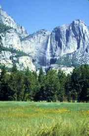
National Park The crown jewel of the Sierra Nevada lies in the center of the 400-mile mountain range with the most distinctive and spectacular glacial valley in California—or anywhere else, by many accounts. Yosemite Valley, 7 miles long and about 1 mile wide, is essentially a stage where people can merely stand and turn their heads to see internationally known landmarks, such as El Capitan, Yosemite Falls, Half Dome, and Bridalveil Fall. The view from Wawona Tunnel entering the valley from Highway 41 causes most people to immediately pull into the nearest parking lot, take out a camera, and begin snapping photographs.
The view is both the blessing and curse of Yosemite. Of the estimated 4 million people who visit Yosemite annually, 3 million of them come to the valley, which has not been considered a wilderness area in many decades. The only time visitors can get an experience uncluttered by streams of other people is in the winter when the cold weather and snow keep the crowds down.
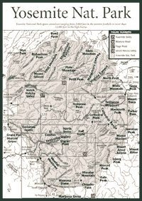
Yosemite National Park is more than 750,000 acres, much of it in the high Sierra above 8,000 feet. It spans elevations ranging from about 2,000 feet in the western foothills to more than 13,000 feet at the crest. The different elevations create microclimates that have a wide diversity of plant and animal life.
But the geology and diminutive Yosemite Valley are the starting points for most visitors. Once people tear their attention from the cliffs and waterfalls in the valley, there is much they can learn here that will help explain the rest of the park, particularly in the geology.
The granite plutons that form the valley's bedrock are between 80 and 120 million years old. They are part of the vast Merced River drainage, which begins in Yosemite's high country about 12 miles to the east at the Sierra crest and races through a deep, rugged canyon. The river's course emerged about 80 million years ago when widespread volcanic activity came to a halt.
At one point about 33 million years ago, the Sierra weather was largely tropical with a lot of rainfall in summer. Some geologists believe the Sierra batholith uplifted more than 30 million years ago and erosion from the rainfall of millions of years cut the V-shaped gorges that were later widened into U-shaped valleys by glaciers.
Other geologists believe the granite of Yosemite Valley uplifted during a period between 25 million and 15 million years ago. They believe that as the uplift occurred, the Merced and Tuolumne rivers cut deep channels in the bedrock. In the past 2 million years, extensive glaciation and erosion opened the deep channels into wide valleys.
Either way, Yosemite was left with two distinctive valleys. Yosemite Valley is the southern feature on the Merced River, and the Hetch Hetchy Valley is to the north on the Tuolumne River. Yosemite Valley became known far and wide as explorers discovered what the glaciers had left behind. They found waterfalls suspended thousands of feet in the air, sheer granite faces mounting 3,000 feet and higher above the valley floor, and a sediment-filled lake in the valley that supported native grasses, flowers, shrubs, and trees.
Half Dome, Yosemite's emblematic feature on the east end of the valley, is a massive dome with granite that probably first formed about 80 million years ago. An Ice Age glacier knocked out the footing below the dome. Other glaciers quarried away fractured slabs of granite until a flattened rock face was fashioned. It is really more of an 80-percent dome, since about 20 percent of the dome was lost.
Yosemite's landscape dates back to about 400 million years ago when it was still beneath the Pacific Ocean. Like the rest of the Sierra, the rocks below the ocean were subject to compressing forces during the movement of the earth's tectonic plates. Over about 175 million years the Sierra slowly pushed up. The rocks metamorphosed or changed slowly from limestone, shale, and sandstone to hornfels and schists, geologists' terms for metamorphic rocks.
Granitic plutons began invading the Sierra rock about 160 million years ago, coming in at least three distinct phases lasting more than 15 million years apiece. It took about 130 million years for the pulses to finish their intrusion. Dramatic volcanics and the Sierra's uplift took place over another 25 million years. The Ice Age glaciers appeared in the last 2 million years, finally subsiding about 10,000 years ago.
But glaciers—or actually glacierets—still exist in the Yosemite high country. They are not remnants of the Ice Age that passed 10,000 years ago. They rest in the large cirques or bowl-shaped depressions cut into mountains during the Ice Age, but these glaciers are a product of the Little Ice Age, a worldwide cooling period from 1700 to 1750. They have melted down to modest ice patches in comparison to the size of Ice Age glaciers. Scientists are not certain, but many believe the ice patches seen today are not remnants of the Ice Age.
In the Yosemite high country, many glaciers can be seen at Mount Lyell, Kuna Crest, Sawtooth Ridge, Mount Conness, and Mount Dana. Most are well above 10,000 feet. The highest is at Mount Lyell at 12,800 feet.
Evidence of glaciers is everywhere in Yosemite. The most common sight is an erratic, a large rock that is definitely out of place in a meadow or perched on a ledge. Erratics were carried on glaciers and dropped in distant places when the ice melted. They can be found in such places as Glacier Point, overlooking Yosemite Valley.
Such glacial evidence is also apparent at Hetch Hetchy Valley, but it might be best viewed by wearing a wet suit and a snorkel. It is underwater beneath Hetch Hetchy Reservoir, which provides water for San Francisco.
The pure mountain water in a national park allows San Francisco the distinction of being one of the largest cities in the country without the need of surface water treatment. Early in the twentieth century, the building of O'Shaughnessy Dam, which stops the Tuolumne River, was a heart-breaking experience for John Muir, the revered naturalist-author who fought a losing battle to stop the dam.
O'Shaughnessy was built less than a century after the first European laid eyes on Yosemite. The first sighting supposedly came in the 1830s by explorer Joseph Walker. He didn't actually camp in Yosemite Valley. Historians believe his party moved through Hetch Hetchy Valley and the Tuolumne River canyon. He probably followed the old Mono Indian Trail, generally along present-day Highway 120 or Tioga Road. The trail took him from the Eastern Sierra to the western slope.
But thousands of years before Walker, the peaceful Miwok Indians lived in Yosemite Valley. They were called the Ahwaneechee (Ah-wah-nee-chee). At one point, the tribe suffered a fatal sickness that led to the evacuation of the valley. Scientists do not know what the illness was.
Many years later in the early 1800s, Tenaya, who claimed to be descended from an Ahwaneechee chief, left the Monos on the Eastern Sierra. He returned to the valley and claimed it as the birth right of his people.
During the gold rush of the late 1840s and 1850s, fighting began between Indian tribes and the Europeans who were searching for gold. Major James D. Savage was sent to quell the Mariposa Indian War. Savage found the mysterious valley—Yosemite Valley—where the tribe lived. Savage's forces were the first Europeans to actually camp in the valley. The date was March 27, 1851.
The tribe was captured and moved to a reservation near Fresno. A homesick Chief Tenaya was allowed to move back into the valley with his immediate family. He died soon after when his group was attacked by eastern Monos. In 1855, all the Indians on the reservation were allowed to return to their original homes.
Yosemite has been the object of study and passion from the 1860s through the present day. People such as Muir wrote about its wonders, setting the stage for a crush of public visitation that only grew with each passing decade in the twentieth century.
The Stoneman House, an elaborate 3.5-story structure, was built for $40,000 in 1886 near the site of the current Curry Village garage. It was one of the early hotels built in Yosemite Valley, and, like many others that followed, it burned down in 1896.
Congress set aside land for Yosemite National Park in October 1890. Muir and his powerful associates had a hand in establishing the park.
The park originally contained 1,512 square miles, excluding Yosemite Valley and the Mariposa Big Trees, which remained under state control as part of the original Yosemite Land Grant created by President Lincoln. The valley would later be turned over to federal jurisdiction. The park size was trimmed back to its present size, a little less than 1,200 square miles, in the next few decades.
Cavalry units were detailed to patrol and take charge of Yosemite. Between 1891 and 1914, military officers and various cavalry units guarded Yosemite's forests.
Camp Curry, operated by the Curry family beginning in 1898, became a center for visitor gatherings. David and Jennie Curry made the hospitality industry a priority in Yosemite.
Those were the days when people simply enjoyed the natural setting without completely understanding how the ecosystem worked. For instance, feeding the bears became a tradition. The black bear (Ursus americanus) became an object of delight. Chairs would be set up for people to toss food into the garbage hills where the bears would feed.
Inevitably, some bears would become bolder and begin approaching people for food. Some bears would learn they could "bluff charge" visitors and the visitors would drop their food and flee. These bears had to be killed.
Today, bears have become a major headache for wildlife managers. Though an aggressive publicity campaign about protecting food has brought down the number of human-bear encounters, black bears cause up to $500,000 of damage annually to visitors' cars and belongings. The bears can be relocated if they become chronic pests, but they must be destroyed when they become aggressive in pursuit of food.
In Little Yosemite Valley, which is along the hike to Half Dome, the bears visit the backpacker campground nightly, raiding campsites. Squirrels, raccoons, and coyotes are also known to wait outside motel doors in the Yosemite Valley for people to feed them.
The natural sources of food are abundant in Yosemite, since it has been a protected environment for more than a century. The vegetation, particularly the trees, offers protection and nourishment for animals of all kinds.
Of the 27 varieties of trees in the park, four are easiest to identify, due to their impressive size and distinctive characteristics. They include the California black oak (Quercus kelloggii), which is abundant in Yosemite Valley. These large deciduous trees, with yellow-green leaves and dark trunks, produce acorns, which many forest creatures, such as squirrels, eat. The other three easily identifiable trees include the ponderosa pine (Pinus ponderosa), with its bark made up of irregularly shaped plates; the incense cedar (Calocedrus decurrens), with a feathery reddish bark; and the giant sequoia (Sequoiadendron giganteum), the largest tree on earth.
Three groves of giant sequoias are in the park. They include the Mariposa Grove near the southern entrance at Highway 41; the Tuolumne Grove, near Crane Flat on the Tioga Road or Highway 120; and the Merced Grove, off the Big Oak Flat Road (another section of Highway 120), between Crane Flat and the Big Oak Flat Entrance.
Yosemite is home to some rare species in the Sierra, such as the peregrine falcon (Falco peregrinus), which has been nesting in such places as the Hetch Hetchy Valley. Other rare species include the red-legged frog (Rana aurora, draytonii) and the mountain yellow-legged frog (Rana muscosa).
Along the many streams in Yosemite Valley and at some higher elevations, visitors will find some rare lichen species as well. They include Dermatocarpon moulinsii, Dimelaena oreina, Hydrothyria venosa, and Umbilicaria torrefacta. Scientists use the lichen in air monitoring because the lichens are so sensitive to air pollution, which already has wiped out some species of lichen in other California mountain ranges, particularly in Southern California.
For travelers who wish to orient themselves quickly in Yosemite, the major roads generally lead to Yosemite Valley. Organizing visits to the areas of interests, such as Tuolumne Meadows in the high country or Glacier Point above the valley, should always provide time for stopping in the valley, which can be crowded in warmer months and even the so-called shoulder seasons in April and October.
Read and add comments about this page