 Monarch
Wilderness/Jennie Lakes Wilderness
Monarch
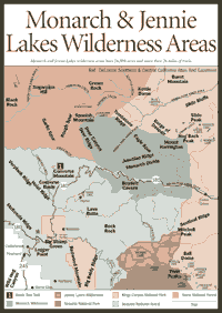
Wilderness/Jennie Lakes Wilderness [Fig. 52, Fig. 53, Fig. 54] The majority of the giant sequoia groves in the Sierra can be found in the Sequoia National Forest, but this forest is much more than a place to see the big trees. The 1.2 million-acre Sequoia forest, established in 1908, contains about 25 percent of the flora species found in California. More than 100 species of plants have been found at Bald Mountain, including the Bald Mountain potentilla (Horkelia tularensis), which cannot be found anywhere else in the world.
People come to the Sequoia primarily for the hiking, backpacking, horseback riding, river rafting, and fishing. At the southern end of the Sierra Nevada, spring comes earlier in the year, so the snowmelt starts earlier than in northern parts of the range. Hikers find they can get into the backcountry in the Southern Sierra weeks ahead of hikers in the Central and Northern Sierra.
The reason the Southern Sierra is relatively dry is that Pacific Ocean storms typically approach from the northwest. The storms usually lose much of their precipitation in the Northern and Central Sierra before they reach the Southern Sierra. However, storm patterns can shift and come from the southwest, packing a lot of precipitation. As always in the Sierra, it is best to be prepared for storms at any time in Sequoia National Forest.
The most primitive and pristine sights in the Sequoia can be found in vast wildernesses along the range's crest, including the Monarch, Dome Land, Jennie Lakes, and parts of the South Sierra and Golden Trout wildernesses. The South Sierra and Golden Trout wildernesses are shared with the Inyo National Forest in the Eastern Sierra.
The glacial canyons are deep and the rivers are wild in this part of the Southern Sierra. Photographers love the landscape here. Throughout Sequoia forest, visitors will see remnants of previous times when logging, grazing, and mining were more widespread than they are today. Indeed, the Sequoia has slowly become more of a recreational forest as logging and grazing have been scaled back.
Logging will be drastically reduced by 2003 when the full restrictions of the Giant Sequoia National Monument apply. The monument, designated in 2000 by President William Clinton under the 1906 Antiquities Act, covers 328,000 acres of the forest, providing huge protection buffer zones for 19,000 acres of giant sequoias. Some logging will be allowed until 2003 so that surrounding timber mills have a short transition period.
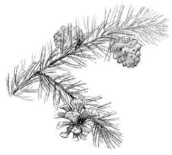
The Sequoia is divided into four sections, with the Hume Lake Ranger District 15 miles north of the main forest and two other sections southeast of the main forest. The Hume Lake district, which has more than a dozen giant sequoia groves, is next to Sequoia-Kings Canyon National Parks. The district includes the Boole Tree, the largest tree in any national forest in the United States. It is 269 feet tall and 112 feet in circumference.
The two other forest sections—each less than 100,000 acres—are south and east of Isabella Lake, an artificial lake created when the Kern River was dammed. The section farthest east contains the 88,000-acre Kiavah Wilderness, which encompasses the Scodie Mountains within the Sierra range. The Kiavah, established in 1994, is an interesting transition zone from the Mojave Desert on the east to the Sierra. Visitors will see many desert community plants, such as burro bush (Hymenoclea monogyra), creosote bush (Larrea tridentata), and Joshua tree (Yucca brevifolia). The Sierra vegetation in this area includes the canyon oak (Quercus wislizenii), pinion pine (Pinus monophylla), and Sierra juniper (Juniperus occidentalis).
In the main body of the forest, people will find the dangerous Kern River, which regularly claims the lives of unsuspecting swimmers. Because of the warmer, drier weather in this part of California—Bakersfield annually receives less than 6 inches of rain—people are lulled into thinking the placid-looking pools on the Kern are shallow and calm. But powerful subsurface currents can drag even the best swimmers down into cold, turbulent water. The message from the Forest Service is clear: Don't swim here.
There can be dangers in other large streams of the Sequoia as well. Experienced boaters and professional guides are probably the safest bet on the Kings River and the South Fork Kings River, both of which are designated for federal protection as Wild and Scenic Rivers.
But there are streams and bodies of water that are not dangerous in the Sequoia. There are some very pleasant hot springs on the Greenhorn Ranger District, which extends far south in the Sequoia. Isabella Lake provides trout fishing for the area. One quirky note for those using a map to find Isabella Lake: The name of the town next to the body of water is Lake Isabella.
Monarch
Wilderness/Jennie Lakes Wilderness [Fig. 55] Though the 45,000 acres of the Monarch Wilderness are almost evenly divided between the Sierra National Forest and Sequoia National Forest, visitors probably will be more interested in the Sequoia side. The Sequoia side is the easiest to get into because the Kings Canyon Highway—outside of Kings Canyon National Park—runs right through the southern part of the wilderness. The highway has been designated as a scenic byway.
To the south, if visitors entering from the west turn right on the Generals Highway, they can easily reach the Jennie Lakes Wilderness, which is almost 11,000 acres of meadows, forests, lakes, and streams. The wilderness has 26 miles of trails, including walking access to both Sequoia and Kings Canyon national parks. The Big Meadows area is a popular cross-country skiing spot. Jennie and Weaver lakes are big attractions for fishing.
The beautiful Monarch Wilderness starts at about the 2,000-foot elevation along the Wild and Scenic South Fork Kings River. As the wilderness rises in elevation, there are lush mountain meadows, spectacular geological formations, and interesting groupings of vegetation that include the whitebark pine (Pinus albicaulis). The Monarch is the only place in Sequoia where the whitebark can be found.
As with many wildernesses, there are no facilities, but visitors can find a picnic ground off of Kings Canyon Highway at Grizzly Falls, which is only a short distance from the highway on a well-marked route. Visitors often stop for a picnic lunch on their way to Cedar Grove in Kings Canyon National Park.
Just a few miles after entering the wilderness area on the highway, visitors may notice the Boyden Cave sign. The cave is just inside the wilderness beneath steep walls of marble. The whole family can tour the lighted trail through the cave between May and October.
[Fig. 55] Converse Basin evokes a range of reactions from many people. Visitors make the long drive from the San Joaquin Valley heat and find a cool, green meadow with soaring granite mountains in the background. People love that first moment. But soon they begin looking around the meadow at the massive stumps of 2,000-year-old giant sequoia. Their hearts sink when they realize they have entered a graveyard of big trees.
Perhaps the most famous of the remains is the Chicago Stump, standing 20 feet high. It and others were left after loggers cleared the giants in the late 1800s and early 1900s. Hundreds of giants were cleared from the area before the U.S. Forest Service acquired about 20,000 acres in the vicinity of Hume Lake in 1935.
For hundreds of years before the loggers arrived in this area, Native Americans gathered here during the summer to gather food and hunt. The groups included the Choinimne, Yokuts, and Michahai. A fair amount of trading went on between tribes of the Eastern Sierra and the western slope. Both digger pine (Pinus sabiniana) and sugar pine provided pine nuts for the tribes.
 These
days, the acorn woodpecker (Melanerpes formicivorus) is among the
creatures most interested in harvesting the local trees. For bird watchers,
Converse Basin can be a delight. Look for the mountain chickadee (Parus
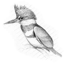
gambeli), belted kingfisher (Megaceryle alcyon), and brown creeper
(Certhia familiaris).
These
days, the acorn woodpecker (Melanerpes formicivorus) is among the
creatures most interested in harvesting the local trees. For bird watchers,
Converse Basin can be a delight. Look for the mountain chickadee (Parus
gambeli), belted kingfisher (Megaceryle alcyon), and brown creeper
(Certhia familiaris).
[Fig. 55(1)] The Boole Tree stands almost alone, the largest giant sequoia saved from the loggers who came through the grove in the late 1800s. It is named after Frank Boole, the manager of the Sanger Lumber Company, which logged the area. No one is sure why the tree was named after Boole, but the tree is 269 feet tall and 112 feet in circumference, making it the largest tree in any of America's national forests. The General Sherman Tree in Sequoia National Park is larger, however.
The Boole Tree Trail traverses the area where the General Noble Tree was cut down in 1895. The tree was carved into 14-foot sections and shipped to Chicago for the Columbian World Exposition.
For loggers, the wood from the giant sequoia was not particularly useful because it was so brittle. It was used mostly to make fence posts and roofing.
 Domeland
Wilderness/Cannell Meadow
Domeland
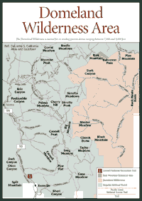
Wilderness/Cannell Meadow [Fig. 56] The Domeland Wilderness is aptly named. Here, hikers, backpackers, and horseback riders can see rugged, eroding granite spires and domes between 7,000 and 9,000 feet in one of the more arid sections of the Sierra Nevada. Visitors will not see much of the wilderness area from a car. Though it can be reached from north, south, east or west, passenger cars cannot get close enough for the good views. You have to walk or ride an animal to really see the Domeland.
Sequoia forest visitors are more likely to start their explorations of this upper Kern River Canyon area in Cannell Meadow, which borders the wilderness on the east. Cannell Meadow can be approached from the southwest on Sierra Way, which connects with a small, east-west route that passes just north of the Domeland Wilderness.
The Cannell Meadow and surrounding areas provide a few campgrounds and several pastures for those who bring their own horses. For those who would like to take a professionally guided whitewater rafting trip down the Kern River, there are several outfitters. They include Chuck Richards Whitewater, PO Box WW, Lake Isabella, CA 93240, phone (760) 379-4444; Kern River Tours, PO Box 3444, Lake Isabella, CA 93240, phone (760) 379-4616; Whitewater Voyages, 5225 San Pablo Dam Road, El Sobrante, CA 94803-3309, phone (510) 222-5994; and Sequoia Outdoor Center, PO Box S, Kernville, CA 93238, phone (760) 376-3776.
Campers, hikers, fishing enthusiasts, and backpackers need to know about plants in this part of the forest that cause skin irritation. Look for stinging nettle (Urtica dioica) and poison oak.
[Fig. 56(1)] The most direct route to Cannell Meadow is a hiking trail over the rugged, roadless area from just north of Kernville. For some folks, it may actually be quicker to walk there than to drive for hours on a circuitous route that runs north along the Kern River canyon. But, for average hikers, this is a lot of walking and almost 1 mile in elevation gain. That's a lot of work, but the views of the Kern River valley are stunning.
If you try this one in the summer, make sure you bring a lot of water—maybe 64 ounces. The trail does not provide a lot of shade. In spring and summer, watch for the western rattlesnake, which has poisonous venom. The rattler generally is a shy snake that remains hidden. Just keep your eyes on the trail as you walk through rocky areas.
[Fig. 56] This is an easy hike to see some wonderful views of the Southern Sierra and also experience Bald Mountain Botanical Area, a 440-acre site on the northern tip of the Domeland Wilderness. More than 100 species of plants have been recorded among the sedimentary rocks that date back more than 135 million years, which is a bit unusual in an area dominated by granite.
The biggest plant attraction is the Bald Mountain potentilla (Horkelia tularensis), which occurs nowhere else in the world. Once you have seen this plant, however, check out the view from the 40-foot-high fire lookout on the mountain. It spans a breathtaking several hundred square miles of the Domeland and South Sierra wildernesses.
 Miracle
Hot Springs
Miracle
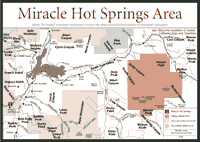
Hot Springs [Fig. 57(1)] Miracle Hot Springs run between 104 and 109 degrees Fahrenheit. Most people find it a soothing, comfortable temperature, especially in the fall or spring when the air is cool at the 2,200-foot elevation of the hot springs. Hot springs are scattered all along the Kern River, venting water that has been heated by the earth's magmatic core. The water absorbs minerals during its underground course through the heated geological formations along the Kern. The minerals found in the hot springs around the Kern are sulfur, magnesium, iron, and borax.
A hobo camp with bathhouses developed at Miracle when the Borel Power Plant was being built in 1901. It was called Hobo Hot Springs in those days. Now, Hobo Campground is about 0.12 mile from the hot springs. The name was changed from Hobo to Miracle in the 1940s when it became known as a place to miraculously relax people.
[Fig. 58] The Golden Trout and the South Sierra wildernesses combine to cover more than 365,000 acres along the Sierra crest, but almost two-thirds of those acres are on the Eastern Sierra. Individual descriptions of both wildernesses can be found in the Eastern Sierra chapter.
Visitors will find 150 miles of trails for hikers and horseback riders in the 111,146 acres of Golden Trout Wilderness in the Sequoia forest. In the smaller South Sierra wilderness, southeast of the Golden Trout, there are about 30 miles of trails in about 24,650 acres. On the Sequoia forest, the Golden Trout Wilderness ranges from about 4,800 feet in elevation to mountain peaks more than 12,000 feet high. The South Sierra Wilderness terrain is a bit less dramatic on the Sequoia forest. But peaks still reach higher than 9,000 feet.
Visitors will find campgrounds on the way to the Golden Trout Wilderness on the Sequoia forest. The South Sierra Wilderness, however, is farther east in less developed areas and has only a few neighboring campgrounds.
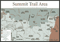 Summit
Trail
Summit
Trail [Fig. 58(1)] The Summit Trail offers hikers many views on the way to scenic Maggie Lakes in the Golden Trout Wilderness. It starts above 8,000 feet where moist meadows often light up with greater elephant's head (Pedicularis groenlandica), which has rose-colored blooms that emerge in July at this elevation.
Up higher near Maggie Lakes, the scenery includes alpine buttercup (Ranunculus eschscholtzii) and Anderson's alpine aster (Alpigenus var. andersonii). In the meadows above 9,000 feet, visitors also can see dwarf huckleberry (Vaccinium nivictum) and red mountain heather (Phyllodoce breweri). Two streams—Mountaineer Creek and Pecks Canyon Creek—should be crossed with care, particularly early in the season when small creeks often swell with snowmelt in the afternoons. Later in the summer, they are not difficult to cross.
[Fig. 58] From Jackass Peak, a fairly quick hike that should not be too challenging, there are interesting views into the South Sierra Wilderness. Albanita Meadow spreads below to the southeast, flanked by 9,145-foot Finger Rock and 9,455-foot Crag Peak. To the southwest, just outside the wilderness, is 9,515-foot Smith Mountain, and 9,050-foot Granite Knob is to the northwest. Though Jackass Peak is above 9,000 feet, hikers can still see vegetation that can be found at lower and drier places in the Central Sierra foothills. That's because it is drier and warmer in this part of the mountain range. Look for the mountain whitethorn (Ceanothus cordulatus) and tobacco brush (Ceanothus velutinus). Also, visitors may see the popcorn flower (Plagiobothrys torreyi).
[Fig. 57] The Kiava Wilderness is not a typical, lush mountain place, but visitors still like to take a lot of photographs around it. The Kiava is 88,290 acres of transition lands filled with characteristics of the Mojave Desert to the east and the Sierra to the northwest. People hike, camp, and take photographs of the eroding landscape and the interesting vegetation. Carry water when you hike this area, and hike it during the spring and fall. Water sources are scarce.
The Kiava, which was established in 1994, is basically the Scodie Mountains, a collection of hills and canyons on the southern extreme of the Sierra. Like the Tehachapi and Piute mountains in this part of California, it is subject to five different wind patterns—the subtropical, Pacific, polar, continental and Gulf wind patterns. It does not receive much more than 10 to 15 inches of rain annually. The climate creates "bajadas" or foot slopes of desert mountains where eroded soil and rocks have accumulated. Groupings of plants might include a digger pine and a Joshua tree. A cactus might grow within 100 yards of a canyon oak. It's not a common sight in the Sierra.
Migratory birds in Kiava are diverse as well. Visitors might see an interesting combination of a rough-legged hawk (Buteo lagopus), yellow-headed blackbird (Xanthocephalus xanthocephalus), gray-crowned rosy finch (Leucosticte tephrocotis), and sage sparrow (Amphispiza belli), depending on the time of the year.
The Kiava is part of the Bureau of Land Management's Jawbone-Butterbredt Area of Critical Environmental Concern. The area was designated to protect the wildlife and Native American sites.
For more information: Cannell Meadow Ranger District, PO Box 9, 105 Whitney Road, Kernville CA 93238. Phone (760) 376-3781. Bureau of Land Management Ridgecrest Field Office, 300 South Richmond Road, Ridgecrest, CA 93555. Phone (760) 384-5400.
Read and add comments about this page