[Fig. 62] The walk up to the top of Mount Whitney could be done as a day hike, so it might seem a little out of place in a chapter about long trails. But anyone who has done Whitney in a day will attest that this is no ordinary day hike. If you're acclimated to high elevation and you're in good shape, it's a challenging 12-hour hike.
If you're not in shape, don't bother trying a one-day roundtrip on this 14,497-foot monster. Adjusting to the elevation alone is worth spending two or three days on Whitney. From Whitney Portal on the Eastern Sierra, the trail starts at 8,360 feet and climbs 2,000 feet in less than 4 miles. That would be a brutal start to any hike, but it's just the warm-up. Hikers still have to climb another 4,000-plus feet over the next 7 miles. As you climb higher, the air gets thinner and your body loses efficiency.
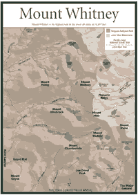
There are other reasons why Whitney should be singled out for special consideration as a long trail in the Sierra. It is the highest peak in the lower 48 states, yet people of all ages and abilities can conquer it. So tens of thousands of people do it every year. At any given time from July to September, the 11-mile trail resembles a freeway of hikers and backpackers. Some have derisively dubbed it "Disneyland with a nosebleed." Sometimes, hikers find groups of 50 or 60 people at the summit.
Many backpackers also come from the western slope of the Sierra. Whitney's flanks easily stretch to the western slope where the mountain is partially in Sequoia National Park. Trans-Sierra backpackers come from many trails. Cedar Grove in Kings Canyon National Park is a popular takeoff point to challenge Whitney. Some prefer to walk from places in Sequoia. From almost any part of Sequoia-Kings Canyon National Parks or Sequoia National Forest, the trip will take several days, sometimes more than a week.
The crowds on the eastern side of the mountain have contaminated the high-elevation
lakes, such as Consultation Lake. Hikers should purify water by boiling,
chemical treatment, or water filter. The U.S. Forest Service has installed
solar
restrooms at 10,640-foot-elevation Outpost Camp and 12,039-foot Trail Camp,
and hikers are encouraged to use them.
For those who camp on the way up, Outpost Camp has some high-elevation pine trees, which many consider more attractive than the barren camping places above the timberline. However, bears occasionally stray up to the area in search of food from backpacks. Trail Camp, on the other hand, is well above the timberline. You won't find much vegetation, but you probably won't encounter large mammals. The yellow-bellied marmot (Marmota flaviventris) can be a formidable and clever pest, however. An average adult marmot might weigh 7 pounds, but the Trail Camp marmots grow several pounds larger as they fatten up on inattentive backpackers' food.
The weather is another consideration on Whitney. Even in August, backpackers may have to cross snow fields. Visitors also will notice some lakes still have ice on them in the summer. It might be 100 degrees Fahrenheit on the floor of Owens Valley to the east, yet the temperature might be in the 50s with 30-mile-per-hour winds at the summit. On summer nights, the wind sometimes gusts up to 40 or 50 miles per hour, and temperatures drop into the 20s. Snow storms have battered the mountain well after the Fourth of July.
Probably the biggest concern for those planning a Whitney trek is a wilderness permit. The U.S. Forest Service limits the number of day hikers and overnight visitors between May and October. Visitors must request a permit in writing between March 1 and May 31. There are so many requests that the trail quota quickly fills in March. Fees are charged for overnight camping. Be advised, rangers patrol the trail and ask to see permits. The rangers will issue citations, and most people caught without a permit are fined.
Entry from the western side of the Sierra is easier. Sequoia-Kings Canyon National Parks issue free overnight permits. Some are available on a first-come, first-served basis.
The crowding problems on Whitney are a recent phenomenon, dating back to the 1970s when 10,000 visitors ascended Whitney in one summer. Now, 20,000 or more visit the summit each year. People have been ascending the peak since it was discovered in 1864 by the California Geological Survey. William H. Brewer led the team. Clarence King and Richard Cotter, who were part of Brewer's team, attempted to climb the highest mountain in the area. When they reached the top of the 14,000-foot peak later named Mount Tyndall, they realized they did not climb Whitney. The Brewer party named the tallest mount after Josiah Dwight Whitney, who founded the California Geological Survey.
King attempted to climb Whitney again seven years later but wound up on the wrong mountain again. In August 1873, three Owens Valley men—Charley Begole, Al Johnson, and Johnny Lucas—climbed to the summit of Whitney. Many other climbs were made, but the first trail from the east side was not constructed until 1904. Residents of Lone Pine built it. A shelter was built on the summit for federal scientists who studied the weather in the early part of the twentieth century.
Today, a shelter remains atop Whitney. There is also a registry where people sign and make comments when they reach the top. The views include eight peaks that are 14,000 feet or higher. The highest grouping is to the north where visitors can see five peaks higher than 14,000 feet.
The rocks on top of Whitney are granite that formed more than 60 million years ago below the earth's surface. Throughout the Whitney area, visitors will find granite with mineral content of mica, quartz, and biotite. The steep eastern escarpment of the Sierra is basically igneous, but the formations that can be seen from the summit just west of Whitney are made up of older metamorphic rocks. Of course, the views to the west also take in the vast San Joaquin Valley, the lower portion of California's Central Valley that stretches 400 miles.
Read and add comments about this page