 Sugar
Pine Point State Park
Sugar
Pine Point State Park The West Shore runs from Tahoe City south along Highway 89 about 10 miles past three major state parks—Sugar Pine Point State Park, D.L. Bliss State Park, and Emerald Bay State Park. The three parks, along with Rubicon Bay and McKinney Bay, give visitors a lot to see and do.
People come here for fishing, hiking, backpacking, camping, and boating of all sorts. The sight-seeing includes the spectacular Vikingsholm Castle, which is modeled after Scandinavian-style architecture. It was built in 1929.
The Desolation Wilderness, one of the busiest wildernesses in the country, is just west of the Lake Tahoe Basin. Permits are required just to hike for the day. For overnight visitors, there are fees required by the Eldorado National Forest where the wilderness is located.
Sugar Pine Point State Park carries the name of a pine tree, the sugar pine (Pinus lambertiana), known for its long pinecone. It was a useful tree in the life of the Native American tribes, which took the hardened fluid from within the tree bark for something schoolchildren could appreciate: They chewed the sugar sweet white nodules like gum.
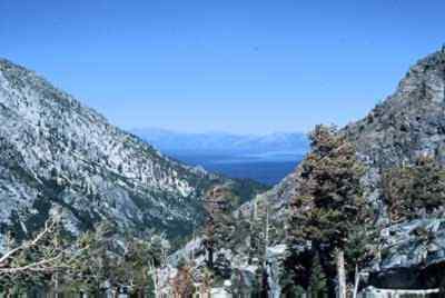
On such routes as the Rubicon Trail, hikers will see volcanic pinnacles as well as evidence of glaciation, which took place sporadically over the last 2 million years in this area. Various hikes will pass granite spires and offer views of Lake Tahoe where glaciers receded only 10,000 years ago. At various elevations, there are bogs and wet meadows teaming with various kinds of wildlife.
Glacier impacts from about 1 million years ago are particularly interesting in Emerald Bay, where visitors can see the scouring effects that canyons of ice inflicted on rock formations around the bay. Yet, amid the evidence of such power, people find the natural elegance of lilies, such as the Indian pond lily (Nymphaea polysepala) at Emerald Bay.
Sugar
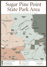
Pine Point State Park [Fig. 30] A deep cultural history brings people to Sugar Pine Point State Park where the Washoe Indians spent warm summers fishing along the peaceful banks of Lake Tahoe in the previous century. Bedrock mortars and grinding stones still can be seen at Sugar Point.
The park has 2 miles of lake frontage, filled with pine, aspen, and juniper. The park is named after a point of land where sugar pine stands congregate.
But the more impressive tree in this area may be the aspen (Populus tremaloides), a slender tree with smooth, greenish-white bark. The oval leaves on this deciduous tree seem to tremble or quake in almost any breeze. Along the lake in Sugar Pine Point State Park, the trees light up the water's edge with golden yellow leaves in autumn.
Out in the water near Sugar Pine Point, brown trout (Salmo trutta) and lake or Mackinaw trout (Salvelinus namaycush) hide under ledges that can be 300 feet deep. People who fish for these trout need long lines and lots of patience. The General Creek provides the clearest water of any stream emptying into Lake Tahoe.
From the turn of the century to 1965, when it became a state park, the 2,000-acre area was owned by the Hellman family of San Francisco. I.W. Hellman, a financier, built a large summer home here in 1903. His daughter, Florence Hellman Ehrman, inherited the estate and entertained guests here until the family sold the Ehrman Mansion and the 2,000 acres to the state parks system. The three-story home, with 12 bedrooms and nine bathrooms, is now maintained and operated as a museum. It is another example of the early-century opulence at Lake Tahoe.
[Fig. 30(1)] The trail to Crag Lake will take hikers from the Lake Tahoe shore into the Desolation Wilderness to the west, so a day-use wilderness permit is required. The trail can be steep and warm. Take plenty of rest stops and drink a lot of water.
Look for wildflowers on the way to Crag Lake. The uncommon Shelton's violet (Viola sheltonii), which occurs only in deep, gravelly soils or in forests up to 8,000 feet, can be seen on this trail. The yellow flower may never have thrived in abundance around Tahoe, and it is a treasured find for any wildflower enthusiast. The more common variety, mountain violet (Viola purpurea ssp. integrifolia) is also found here. Recognize it from the dark green leaves and purple petals.
The Desolation Wilderness along this trail features granite spires and outcroppings along with an open forest of Jeffrey pine. Lake Genevieve is an inviting spot to rest, but keep going for about another 0.5 mile to find scenic Crag Lake.
The family might enjoy this outing. But make sure everyone is prepared for a full day of hiking, picnicking, swimming, and sunbathing.
[Fig. 29(3)] Families can enjoy short or long rides on the West Shore Bike Path because there are so many stopping places to picnic, see the sights, or simply stop to rest along Highway 89. The trail goes for about 10 miles to Sugar Pine Point State Park, but many people do not ride that far.
For instance, a nice brunch ride would take visitors about 4 miles to Sunnyside, a place with picnic tables and views of the lake with no fees. About 1 mile away Kaspian Recreation Area also offers picnic areas with no fees, along with beach access near campgrounds operated by the U.S. Forest Service.
About 5 miles farther is Sugar Pine Point State Park, where fees are charged for entry. For some people, this would be a morning ride, a picnic lunch, and an easy ride back in the early afternoon. For others who like to take it a little slower, it would be an all-day affair.
[Fig. 30(2)] The trail is a gentle 4-mile round trip into the Blackwood Canyon to the west on Forest Road 3. It is a good beginner and intermediate cross-country skiing area.
The canyon, formed over the last 15,000 years by Blackwood Creek, becomes a challenging course beyond the road where more experienced skiers can ascend to Barker Pass at about 8,000 feet. Forest Service officials warn the area beyond the paved road is prone to avalanches.
 D.L.
Bliss State Park
D.L.
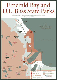
Bliss State Park[Fig. 31] Emerald Bay and D.L. Bliss state parks, two nearly adjoining parts of the state parks system, encompass 1,830 acres, and the core area of Bliss is about 750 acres. Many activities are common to both—fishing, swimming, boating, and hiking. But Bliss has a natural feature that distinguishes it from Emerald Bay: the Balancing Rock.
The 130 tons of granite in the northwestern part of the park are balanced on the slender base of two stone pedestals, which are eroding and cracking. Eventually, the supporting rock will crumble, and the large rock on top will come crashing down. The rock can be seen and photographed on a 0.5 mile, self-guided tour.
The thin granitic soil away from the shoreline allows only hardy trees with root systems that can spread for some distance along the ground to find nutrients. Often the trees, such as ponderosa pine, Jeffrey pine, and white fir, are gnarled and stunted.
Closer to the water, along stream banks and Tahoe's bank, the vegetation becomes lusher as the soils become deeper. Look for mountain alder (Alunus tenuifolia), aspen (Populus tremaloides), and creek dogwood (Cornus californica). The reddish-stemmed dogwood will blossom in white, round-topped clusters in April around Bliss park.
D.L. Bliss State Park is named for a pioneering lumberman, railroad owner, and banker of the region. His family donated 744 acres to the state parks system in 1929.
 Rubicon
Trail
Rubicon
Trail [Fig. 31(1)] The Rubicon Trail allows visitors to hike along the shore of Lake Tahoe between D.L. Bliss State Park and Emerald Bay State Park. On clear, calm days, people can see features 50 to 70 feet deep in the water—a bit different from 100-foot-plus depths people could see 30 years ago in the lake. As development continues around the lake, wastes contribute to large algae blooms and cloudy water.
The trail takes hikers past the Old Lighthouse. Unused today, the lighthouse is surrounded by conifers that partially block a once magnificent view of the lake.
Hikers will notice the aroma of the tobacco brush (Ceanothus velutinus) along the Rubicon. This shrub combines with other vegetation, such as alpine prickly currant (Ribes montgenum) and pinemat manzanita (Arctostaphylos nevadensis), to fill out the understory beneath pines in the area.
In spring and summer, hikers will see the osprey (Pandion haliaetus), an efficient fishing bird, nesting in nearby trees. The osprey is considered a species at risk in the Sierra. Development of wildlands and diminishing habitat are among the osprey's biggest problems.
[Fig. 31] Boating, wildlife viewing, and scuba diving are all popular activities at Emerald Bay State Park. Vikingsholm Castle is a favorite for touring. The castle was built on the shore, and a smaller stone structure, called the "Tea House," is built on Fannette Island, the only island in Lake Tahoe.
Geologists believe Fannette survived a siege of glaciers over the last 1 million years. The granite island simply resisted the forces of glacial erosion and now rises about 150 feet above the water. It is sparsely populated with timber, mostly sugar pine.
Look for various migrating birds and shorebirds in this area, particularly the Wilson's warbler (Wilsonia pusilla). The warbler's sharp, staccato call can be heard from the plant cover. The bird snatches flying insects near the water's edge. In this area, warblers and other birds feed on the stoneflies (order Plecoptera), Thirps (order Thysanoptera), and water striders (family Gerridae).
On the West Shore, biologists say wolverines (Gulo luscus) were once a big part of the ecosystem. Wolverines are considered quite rare in the Sierra Nevada now, victims of poaching and the encroachment of civilization. They were once abundant from Tahoe south to Giant Forest in Sequoia National Park.
Like the grizzly bear (Ursus arctos), which disappeared completely from the Sierra in the 1920s, wolverines created a balance in the ecosystem by staking out territory that mountain lions (Felis concolor) and coyotes (Canis latrans) would routinely avoid. Grizzlies and wolverines had a habit of taking kills from the lions and coyotes.
With lions and coyotes avoiding certain territories, there were reasonably safe places for many creatures such as the mountain or bighorn sheep (Ovis canadensis). Without the protection of the larger predators, the sheep population has dwindled to 100 on the East Side of the Sierra, and it is listed under the federal Endangered Species Act. Other smaller creatures, such as the southern grasshopper mouse (Onychomys torridus) and the panamint chipmunk (Tamias panamintinus), are slowly disappearing, and many believe it is because of the ecosystem imbalance.
The human species has had no such trouble in Emerald Bay. In the 1920s, Lora Josephine Knight purchased Fannette Island and some land on shore. She commissioned the construction of Vikingsholm and the "Tea House." Only the stone shell of the Tea House remains today, but decades ago Mrs. Knight would entertain guests for tea in the 16-by-16-foot room.
On shore, touring the castle is like stepping back into medieval times. It has a sod roof over two sections, and several other parts of the structure have no nails or spikes. The castle also has six fireplaces. The second floor furnishings were constructed in detail to replicate Scandinavian design.
In 1994, Emerald Bay was also designated an underwater state park because of the artifacts that can be found on the bottom of the lake in this area. Scuba divers will find artifacts near the old Emerald Bay Resort on the north shore of Emerald Bay. One diver saw a Model A Ford. Other items from the past include telephone batteries, sinks, toilets, and an old pier. Divers are reminded not to remove or disturb artifacts.
[Fig. 31(2)] This short walk up to Eagle Falls is surrounded with lush vegetation. Look for aquatic perennials such as the buckbean (Menyanthes trifoliata), which roots from submerged rhizomes, as well as the yellow pond lily (Nuphar lutea ssp. polysepala) in calm pools of water, away from the falls.
The falls usually slow down in late summer as the snowmelt subsides in the high Sierra. For a good look at roaring falls, make this hike in May or June.
Read and add comments about this page