 Mammoth
Lakes Mammoth
Lakes
Mammoth
Lakes Mammoth
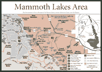
Lakes [Fig. 42] In many ways, Mammoth Lakes epitomizes the Eastern Sierra—in climate, recreation opportunities, geologic features, and vegetation. Visitors can see a place where scientists found a 500 million-year-old rock. They can swim or boat in glacial tarns tucked below the Sierra crest on the Eastern Sierra. They can ski or snowshoe in winter. They can find the full range of Eastern Sierra vegetation on the different elevations.
And visitors can feel the earth move under their feet. Swarms of earthquakes—literally thousands—hit Mammoth Lakes. Federal officials have an alert system that is triggered anytime the Mammoth Lakes area has an earthquake registering 6.0 or higher on the Richter scale.
There is active magma below the Sierra in this region. Mammoth Mountain, though it has not been active in thousands of years, could still erupt some day, according to the U.S. Geological Survey. Located just 3 miles west of the town of Mammoth Lakes, it is venting huge plumes of carbon dioxide. The gas has been so concentrated that it has killed more than 20 acres of conifers near Horseshoe Lake.
Scientists say there is no danger at the moment because the carbon dioxide is cool. Mount St. Helens in the Pacific Northwest belched hot carbon dioxide before it blew 20 years ago. But people get nervous about Mammoth Mountain anyway. The mountain is one of a series of volcanoes on the shoulder of a massive and ancient blast that left a valley 19 miles long and 10 miles wide. The blast that created Long Valley Caldera, as it is now called, occurred 730,000 years ago.
Mammoth Mountain began building on the edge of the caldera about 180,000 years ago as lava filled with feldspar and mica poured out of it. Mammoth is the oldest in the series of volcanoes that stretch about 30 miles north to Mono Craters. The younger volcanoes began building about 40,000 years ago, and many have been active in the last 500 years.
The cold climate above ground plays a big role in the lives of people, wildlife, and plant life around Mammoth Lakes. Snowfall at Mammoth Mountain averages about 30 feet a year. Winter is long and cold around the scenic lakes, including Twin, Horseshoe, McLeod, and TJ lakes as well as Lake Mary, Lake George, and Lake Mamie. The tree communities include hardy conifers such as the lodgepole pine (Pinus murrayana), red fir (Abies magnifica), whitebark pine (Pinus albicaulis), and mountain hemlock (Tsuga mertensiana).
Only 15 miles or so to the east, the plant communities are dramatically different. Plants here adapt to the lack of moisture; only 10 inches of rain falls in the desert east of the Sierra. Inyo bush lupine (Lupinus excubitus), bee plant (Cleome lutea), and hopsage (Grayia spinosa) are flowering varieties of the plants visitors can expect to see.
For fishing enthusiasts, there are five kinds of trout in the lakes and streams around Mammoth Lakes. The rainbow trout is planted throughout the area and is widely fished. Other fish include the golden trout (Oncorhynchus aguabonita), Lahontan cutthroat trout (Oncorhynchus clarki henshawi), Eastern brook trout (Salvelinus fontinalis), and brown trout (Salmo trutta).
Visitors to the higher elevations will no doubt hear the shrill call of the chickaree (Tamiasciurus douglasii). The small squirrel usually remains high in trees, watching for intruders and searching for food. Its biggest enemy is the pine marten (Martes americana).
The first humans to live in this part of the Eastern Sierra were the Paiutes. They traded with the nearby Kuzedika, who lived around Mono Lake. The Kuzedika were known as fly eaters, because they collected the fly larvae of the alkali fly around Mono Lake, dried it, and ate it. They also traded it to Paiutes.
These Native American groups generally lived in peace. They survived the extreme temperatures on the Eastern Sierra by fashioning shelters from bent poles and covering them with grass and sagebrush bark. They ground pine nuts from the Jeffrey pine into a kind of meal. The pine nuts gathered in warmer months had to last through the long winters.
[Fig. 42] Some people come here because it's an easy walk for the family. Others like the view of 12,275-foot Mount Morrison. Fishing enthusiasts find a lot of rainbow trout (Oncorhynchus mykiss). But if you like looking at the geology around a lake, this is a special place.
Tiny fossils found at the base of Mount Morrison have been determined to be 500 million years old. Fifteen thousand-year-old glacial moraines are apparent at the mouth of Convict Canyon. And the metamorphic rock layers and formations in the hillsides next to the lake are among the oldest in the Sierra, dating back some 350 million to 400 million years.
The white boulders scattered along the hillside near the lake are 135 million-year-old granodiorite that rode out of the backcountry on glaciers. Look for sandstone, marble, phyllite, and chert.
Convict Lake has a fair amount of human history, some of which is not pleasant. The lake's name came from an 1870s incident involving a prison break by 29 inmates at the Nevada State Penitentiary in Carson City. Six of the 29 went south toward Mammoth Lakes and apparently killed a mail rider who looked like one of the prison guards.
A posse tracked the six outlaws to Convict Canyon where a shootout occurred. Robert Morrison, posse leader, died in the gun battle. Mount Morrison is named after him. The six inmates escaped the area but were recaptured near Bishop a few days later.
Another more recent tragedy involved the deaths of seven people at Convict Lake in 1990. Three teenagers began playing on the lake's ice on a February day. The ice broke and the three teens died. Four adults also died trying to save them from the icy water.
[Fig. 42(2)] The lake is in a beautiful setting just beneath the Mammoth Crest. It is about as far west as you can go to find a glacial lake in this area. People catch and release fish, but swimming is not allowed in this lake because federal officials want to preserve its cold, pristine water and ecosystem. Picnics on the sandy beaches are popular here.
Depending on the time of year, visitors may have a lot of company on the short, steep trail to the lake. Try hiking this trail on a weekday.
The rugged mountains around the lake are dotted with red fir (Abies magnifica) and whitebark pines (Pinus albicaulis) with an occasional mountain hemlock (Tsuga mertensiana). On the trail up to the lake, note the water birch (Betula occidentalis), considered common along streams on the Eastern Sierra but rare on the western slope.
The wildlife at the lake includes the mountain yellow-legged frog (Rana muscosa), which is found between 7,000 feet and 11,500 feet in the Sierra around lakes. The tadpoles of these frogs spend the winter in ice-covered lakes and emerge as frogs the following year.
[Fig. 42(3)] The trail to Valentine Lake is almost the length of a 10-kilometer race, but very few people race up this course. You will spend most of your morning walking this trail. And the views at Valentine Lake will not disappoint you after all the effort.
This lake at almost 10,000 feet is filled with outdoor delights. To the east, hikers will see 11,800-foot Laurel Mountain. To the west, the Mammoth Crest juts out at more than 10,000 feet.
In meadows nearby the lake, see wildflowers in August. Look for Sierra primrose (Primula suffrutescens), alpine saxifrage (Saxifraga tolmei), and shaggy hawkweed (Hieracium horridum).
[Fig. 42(4)] The hike starts at 9,265 feet, so visitors should be ready for high-elevation walking. They should also be ready for some of the best views on the Eastern Sierra. That's the reason people come up to walk on this Sierra rooftop. Bring the camera and film as well as plenty of water and a windbreaker for the windy mountaintops.
The trail traces the Sierra divide, meaning the precipitation that falls to your left goes out streams to the Pacific Ocean and the precipitation on the right goes down to the lakes on the Owens Valley floor. The color of the soil in many places is white with pumice fragments launched by volcanic eruptions about 20,000 years ago.
[Fig. 42(5)] Mammoth Mountain is considered one of the most exciting downhill runs in California. The longest run is about 3 miles with a vertical drop of 3,100 feet. But skiers of all experience levels can experience Mammoth Mountain.
About 30 percent of the resort's slopes are devoted to novices, and another 40 percent are for intermediate skiers. The remaining 30 percent are for advanced skiers.
Mammoth provides more than 3,500 acres of skiing that include wide-open bowls, steep chutes, and tree-lined runs. There are 150 trails with names like Hangman's Hollow and Sesame Street. Twenty-eight lifts move people between the lodges at the resort, called Main Lodge, Canyon Lodge, and Juniper Springs, and the tops of the ski runs.
Though the season runs from November to June, people have skied on Mammoth on the Fourth of July. This area near the Sierra crest sometimes gets more than 50 feet of snow in a winter. But, in the California drought from 1987 to 1992, the area suffered just like the rest of the state, and skiing could sometimes end before Memorial Day.
Read and add comments about this page