 Marshall
Gold Discovery State Park
Marshall
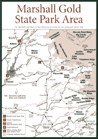
Gold Discovery State Park [Fig. 19, Fig. 20, Fig. 21] The 1.2-million-acre Eldorado National Forest was created in 1905 for the Forest Service to manage the timber and grazing resources. The forest has the Desolation Wilderness, about 63,500 acres to the northeast, and the 105,000-acre Mokelumne Wilderness to the southeast. Both have hiking trails, wildflowers, and wildlife viewing.
The foothills in the forest and just west of the El Dorado are filled with recreation opportunities, natural history, and cultural richness. James Marshall's discovery of gold occurred just west of the forest. Some of the finest whitewater runs in California can be found on the American River, within and just outside forest boundaries. And foothill wineries just outside the western boundary of the forest are slowly making a name for themselves along Highway 50, which was once the route of the Pony Express.
The El Dorado also was known as a trans-Sierra corridor for pioneers in the nineteenth century. After Marshall's gold discovery, wagon trains came through regularly between 1850 and 1870.
One of the more interesting attractions is Robbs Hut, a rebuilt fire lookout. People can rent it and spend days in an area where the Forest Service once searched the horizon for any hint of smoke. For high Sierra sights, the El Dorado has the 10,380-foot Round Top, a granite spire that lives up to its name: It is quite round and barren on top.
Marshall
Gold Discovery State Park [Fig. 19(1)] A good piece of California history resides at Marshall Gold Discovery State Park, which commemorates the area where James Marshall found gold and started the gold rush in 1848. Museums and exhibits tell Marshall's story. Visitors can even pan for gold here.
Gold-bearing quartz veins often came in groupings, which were dubbed "lodes." The Northern Sierra foothills contain a metamorphic belt that produced about three-quarters of a billion dollars worth of gold in less than 20 years. It is still known as the "Mother Lode." Marshall Gold Discovery State Park today marks the birthplace of the Mother Lode in Coloma, just northeast of Sacramento and just west of present-day El Dorado National Forest.
Researchers are trying to piece together the mining history of Coloma. In the 1990s, scholars in search of gold rush-era building foundations found a late-1800s mining operation. Sometime in the 1890s, long after the 49ers had given up on their dreams of instant riches and returned home, a group of hopeful miners worked over the abandoned land in anticipation of finding a previously undiscovered vein of gold.
They tore down the decaying buildings and dug up the land beneath them. Teams of men forced the dirt through long sluices tossing large cobbles behind them as they worked. Fifty years after the discovery of gold, Coloma still remained a popular spot for eager gold seekers.
 Archaeologists
also recovered a lot of relatively undisturbed Chinese artifacts, which
may indicate the ethnicity of the miners and the location of their temporary
living site. Researchers also uncovered several postholes in this lot that
indicate the existence of a post-mining era structure. In recent years,
the archaeologists have set up tables at the Marshall park and invited the
public to observe the activities of the excavators and talk to crew members.
Archaeologists
also recovered a lot of relatively undisturbed Chinese artifacts, which
may indicate the ethnicity of the miners and the location of their temporary
living site. Researchers also uncovered several postholes in this lot that
indicate the existence of a post-mining era structure. In recent years,
the archaeologists have set up tables at the Marshall park and invited the
public to observe the activities of the excavators and talk to crew members.
The history of Marshall's discovery is well known. On January 24, 1848, Marshall found what erosion and the elements had been slowly revealing over the past 20 million years: gold. Marshall and his work crew were camped on the South Fork American River at Coloma. The crew was building a sawmill for John Sutter.
A few tiny gold nuggets, heavier than most other rocks, washed down and Marshall found them on that chilly January morning. Thus began the migration of half a million people from around the globe in search of gold and riches.
Gold began forming in these foothills a long time before Marshall, Sutter, and all the miners came. Between 80 million and 200 million years ago, 100 massive plutons (named after Pluto, the Roman god of the underworld) intruded into metamorphic marine layers beneath the Pacific Ocean.
Over many millions of years, magma, from which the pluton rocks were formed, continued to heat, cool, and crystallize into pyroxene, amphibole, biotite, and olivine. Later in the process, plagioclase feldspars and quartz formed. These minerals sealed veins in the sheets of granite and other rock, forming concentrations of asbestos, chromite, iron, silver, gold, and others.
Less than 50,000 years ago, the surrounding foothill areas began to fill with the many grasses of Central California. Though native grasses can be found, California's foothills and grasslands are now dominated by alien grass species. Many of them are native to the Mediterranean region and were transported to California by Spaniards and Mexicans. The seeds were meant to feed livestock. Others were probably carried in on the coats of animals.
 By
the mid-1800s, the alien varieties had a stranglehold on the grasslands.
Some of the native bunchgrasses still exist. They include the foothill bluegrass
(Poa scabrella) and the purple needlegrass (Stipa pulchra).
By
the mid-1800s, the alien varieties had a stranglehold on the grasslands.
Some of the native bunchgrasses still exist. They include the foothill bluegrass
(Poa scabrella) and the purple needlegrass (Stipa pulchra).
[Fig. 19(2)] Get a tour of the old powerhouse and a dose of history at the Folsom Powerhouse. Visitors can also see such natural sights as meadowfoam (Limnanthes alba), a white flower with white hairs on the stems. It is found in low areas where moisture accumulates. Wildflower lovers should also look for Fremont's tidytips (Layia fremontii), a stunning yellow flower that blooms in May in the Folsom area.
Gold mining created the town of Folsom and contributed the momentum to build the historic Folsom Powerhouse on the American River east of Sacramento. The sons of Horatio Livermore embraced the idea of hydroelectric power in the early 1890s, when experiments had been successfully completed on a limited basis in Germany and New York. Nothing had been attempted that was on the scale of the Livermore project.
They built a canal 9,500 feet long, which provided water to power four large electrical generators that had been built up the stone dam across the American River. The water also powered the bulkhead and headgates for the canal. The canal itself was finished in 1893. Folsom State Prison was the first to benefit from the dam when it put its own hydroelectric powerhouse into operation, also in 1893.
By 1895, the main powerhouse complex was completed and was ready to transmit power to Sacramento. It consisted of four 750-kilowatt electrical generators (also called "dynamos"), each more than 8 feet high, weighing more than 57,000 pounds. The General Electric Company manufactured them. The concept was simple: Turbines were driven by water surging through four 8-foot diameter penstocks. The generators have been altered a little over the years. The basic equipment is still where it was when the plant shut down in 1952. The plant closed because other sources of power became available, and owners decided not to continue this comparatively small project.
The state Department of Parks and Recreation acquired the Folsom Powerhouse project area, along with about 0.5 mile of the canal, as a donation from Pacific Gas & Electric Company in 1958. In the late 1960s or early 1970s, interpretive panels and displays depicting the history of the Folsom Powerhouse were installed in the garage at the north end of the office/shop building.
The Folsom Powerhouse is listed on the National Register of Historic Places (1981) as being significant in the areas of engineering and industry. It has been said that it represented a momentous advance in the science of generating and transmitting electricity. It is also a National Historic Civil Engineering Landmark (1975) and a National Historic Mechanical Engineering Landmark (1976), and it is designated as a California Registered Historical Landmark.
[Fig. 19(3)] The 35,000-acre Auburn State Recreation Area stretches along 40 miles of the North and Middle Forks of the American River where thousands of gold miners swarmed in the 1850s. Now, it is a recreation area for more than 500,000 visitors annually.
More than 100 miles of hiking and horse trails wind through the steep American River canyons and along the American River. The most famous trail is the Western States Trail, which runs 100 miles from Lake Tahoe to Auburn, with over 20 miles in the recreation area. A map showing the trails is available from the recreation area office.
Mountain bicycling is a popular activity as well. The maximum speed on all trails is 15 miles per hour. The maximum speed is 5 miles per hour when passing pedestrians and equestrians and when approaching blind curves.
The historic Stagecoach Trail from Russell Road in Auburn to the Old Foresthill Road Bridge on the North Fork of the American River connects with the fire road to the West End of the big Foresthill Bridge.
The recreation area offers a 9.5-mile run on the North Fork American from the Iowa Hill Bridge to Ponderosa Bridge. Several difficult rapids are encountered, most notably these: Chamberlin Falls, Staircase Rapids, and Bogus Thunder. Trips down this river are typically made in one day.
Boating the North Fork requires a sound background in technical whitewater skills. The most desirable flow range is between 1,500 and 3,000 cubic feet per second (3,000 to 6,000 acre-foot flows per day).
In the recreation area, one-, two-, or three-day trips are available on the challenging Middle Fork American River. The 15-mile run from Oxbow put-in to Greenwood take-out features several very fast rapids, as well as numerous slower rapids. Most notable are the Tunnel Chute and Kanaka Gulch.
Where the water does not run so fast, the riparian woodland has a variety of vegetation worth seeing. White alder (Alnus rhombifolia) and the bigleaf maple (Acer macrophyllum) are among the most common sights in the recreation area.
Riparian or riverside vegetation is reduced to a thin ribbon around the river in steeper, rocky terrain. But as the river reaches more gentle inclines farther down the mountain, nearer to the Central Valley, the soils become looser, more saturated with nutrients, and able to support more plant life.
Shrubs include California pipe vine (Aristolochia californica), osoberry (Osmaronia cerasiformis), and California wild grape (Vitis californica). All are fairly uncommon shrubs in the Sierra foothills, except alongside streams such as the American River.
Sometimes, natural history is easiest to find just a few feet from an interstate highway. On the way to Auburn State Recreation Area, the edges of an eroded granite pluton perhaps 50 million years old are apparent along Interstate 80. It was a single bubble of granite that somehow separated from the main plutons many miles away.
Black Mariposa slate can be seen just beyond the pluton to the east. A small ridge farther east is actually a former rolling hill that was part of the Sierra more than 50 million years go, long before the range's uplift tilted the ridge. To the west, visitors can find younger sediments from Sierra erosion over the past 20 million years.
[Fig. 19(4)] When people think of California wineries, they're usually thinking about the ones in Napa. But the Central Sierra foothills are slowly becoming known for the fruit of the grape. People make a brief tour of the wineries along Highway 50, west of Lake Tahoe, and enjoy tasting wines in an area that actually has a bit of history in wine-making.
In the nineteenth century, when Napa was known for prunes, Sierra Nevada foothill communities had several dozen wineries. The wineries sprang up in El Dorado County after the 1849 Gold Rush. Miners needed to diversify their work as the mining craze died out.
But population in the gold mining areas began to dwindle. By the beginning of the twentieth century, there were fewer wineries. Then Prohibition snuffed out whatever was left of the winery business. Soon, El Dorado County became more known for timber.
The 1970s brought new interest when a member of a Napa wine family invested in a Placerville pear orchard and replanted it with wine grapes. The buyer, Greg Boeger, a descendent of the Nichelini family of Napa, realized the climate in the foothills was very close to the Napa climate—warm summers, dry autumns, and cool, wet winters.
Others saw Boeger's success and began moving into El Dorado County. Now almost two dozen wineries are flourishing in this area. The highest is at 3,000 feet in elevation. Some of the more popular types of wines include chardonnay, cabernet sauvignon, and zinfandel. The Boeger spread, about 50 acres, grows 25 different kinds of wine grapes.
Wine tasting and touring is slowly becoming a tradition in the Central Sierra foothills. The wineries are generally located along Highway 50 about an hour west of Lake Tahoe just east of Placerville. Most open on weekends for tasting and some are open daily. Picnic areas are available for those who wish to bring a basket and purchase a bottle of wine.
The wineries also benefit from the multitude of apple orchards in the area. Each autumn, people take the turnoff near Placerville—Schnells School Road from the west or Carson Road from the east—to visit the apple orchards to sample the fruit. People usually like to pick their own. And, right next door to the largest orchards, they find wineries.
Other wineries are scattered throughout the foothills all the way down to Mariposa County near Yosemite. According to many wine experts, the foothill wineries are gaining on the prestigious the Napa-area wineries.
People are beginning to mark their calendars for April because the El Dorado wineries get together to present Passport Weekend. On the first and second weekends of April, people can buy a two-day pass to 18 wineries to eat gourmet food and cheeses as they sample wines. About 2,500 people attended in 1999.
[Fig. 20(3)] A stay at Robbs Hut is a chance to get away from it all for several days and sample the rustic, simple living of fire lookouts. The views are magnificent if you don't mind a little hiking to get to Robbs Hut. This slice of outdoor life was made possible by the U.S. Forest Service's change in thinking about fires.
The U.S. Forest Service began spotting Sierra fires and snuffing them quickly in the early part of the twentieth century, building many lookouts such as Robbs Hut in the El Dorado National Forest. The mountain hut, constructed in 1934 and decommissioned from active status in 1978, is a midelevation Sierra vantage point at 6,686-foot Robbs Peak, and it is a delight for outdoor enthusiasts who can now rent it for overnight use.
Just as the Forest Service's use for Robbs Hut has changed, its practice of extinguishing forest fires on sight has been altered. One person would reside in lookouts such as Robbs Hut from late June until early September, watching for fires all day and, in very dry conditions, seven days a week.
The practice of suppressing the fires led to overgrown brush at many elevations in the Sierra. Biologists, ecologists, and the Forest Service had no idea that thick brush would set up the ecosystem for huge wildfires that would climb to canopies of even the highest trees. Such a fire burned hundreds of thousands of Sierra woodland acres in 1978.
Finally, officials began to understand why the Miwok and other tribes many centuries ago regularly burned understories of brush. The Native Americans knew the forest ecosystem relied on fire to thin out areas and create places where natural competition would allow a diverse biotic community.
Fire promoted the basic forest health that Native Americans needed. It also opened clear areas through which tribes could see surprise attacks and defend themselves.
Now, the Forest Service and the National Park Service allow some areas to burn naturally when lightning sets off fires. It is still important to spot the fires, but now government agencies are using fire as a forest management tool to protect resources.
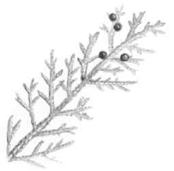
The resources being protected around Robbs Hut are typical of the 3,000- to 7,000-foot elevation on the Central Sierra's west slope. In some tree stands around Robbs Hutt there are five different conifers. The white fir (Abies concolor) is at somewhat higher elevations. The yellow or ponderosa pine (Pinus ponderosa) is more acclimated to the lower end, more easily adapting to drier conditions. Other trees include the sugar pine (Pinus lambertiana), incense cedar (Calocedrus decurrens), and the black oak (Quercus kelloggii).
Robbs Hut is not for the inexperienced hiker or outdoors person. Access to the Robbs Peak Lookout during winter and early spring is by foot, skis, or snowmobile, depending on snow conditions. At the bottom of the road to the hut there is a gate, which is always locked in the winter. The Forest Service will provide combinations to the locks for anyone who rents the cabin.
The road into the area is passable in a regular automobile during summer, but it is not plowed in the winter. At times, a four-wheel drive vehicle is required to get up the road.
The elevation gain from the parking area to the bunkhouse is more than 1,000 feet. The trip from the car to the hut can take from two to six hours to complete.
 Desolation
Wilderness
Desolation
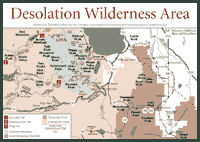
Wilderness [Fig. 20] Visitors can see what the retreating glacial age left behind 10,000 years ago in the 63,500-acre Desolation Wilderness—150 alpine and subalpine lakes in the ancient, high-elevation granite. Unfortunately, there are sometimes so many people hiking here that it feels less desolate and less like wilderness than almost any other Sierra wildlands.
The lakes, the glacial remnants, and the sights make it one of the most popular wildernesses in California. It is also popular because it is so conveniently located on the busy corridor between Lake Tahoe to the east and San Francisco and Sacramento to the west.
In Glen Alpine Valley, the signs of a glacier's passing are apparent on the roche moutonnée found there. The granite feature was fashioned by a glacier that wore away a massive boulder in a gradual plane on one side and in a sharper, more jagged way on the other. About 20,000 years ago, a glacier created these landmarks in Glen Alpine Valley as well as in Desolation Valley to the southwest.
The name "roche moutonnée" came from Horace Benedict de Saussure. When he saw the features at Tuolumne Meadows in present-day Yosemite National Park, he called them roche moutonnée, meaning they looked like a flock of "rock sheep" at a distance.
Driving up Highway 50 to the Desolation Wilderness, the road cuts reveal a deep history of the Sierra in the Eldorado National Forest. At one point, before reaching Echo Summit, visitors will see a low spot between Pollock Pines and Riverton at the South Fork of the American River. Through erosion of the volcanic ash, perhaps 5 to 10 million years old, the oldest sedimentary rocks on the western slope of the Sierra are exposed. The sedimentary rocks date back to 200 to 300 million years ago before the sea floor began descending.
Within the wilderness, the granite batholith peeks out from beneath the volcanic rock as well. Elevations range from 6,500 feet to more than 10,000.
The elevations create interesting habitats that attract an array of wildlife. The lower elevations of the Desolation Wilderness provide cedar and fir trees that seed-eating creatures prefer. California ground squirrel (Citellus beecheyi), deer mouse (Peromyscus maniculatus), bushy-tailed wood rat (Neotoma cinerea), and Steller's jay (Cyanocitta stelleri) are good examples.
Visitors also may encounter the California mountain king snake (Lampropeltis zonata), a 20- to 40-inch snake with red, white, and black bands circling its body. This is a very secretive snake, but it is also extremely common, so visitors might see one in the moist forest near rocks or along a stream with fallen timber nearby. Don't distressed. This snake is completely harmless.
In the subalpine meadows of the wilderness, the volcanic soils are loose and filled with nutrients to grow such plants as the subalpine shooting star (Dodecatheon subalpinum), which requires moisture and soils that allow its root system to easily develop. When soils become soggy—especially in meadows where the snowmelt is considerable in June and July—the greater elephant's head (Pedicularis groenlandica) is found, growing a beautiful pink to deep rose-colored flower.
The Desolation Wilderness also has numerous migratory birds that visit the upper-elevation forest, known as the red fir (Abies magnifica) and lodgepole pine (Pinus murrayana) belts. The common merganser (Mergus merganser), olive-sided flycatcher (Nuttallornis borealis), Brewer's blackbird (Euphagus cyanocephalus), chipping sparrow (Spizella passerina), and the pine siskin (Spinus pinus) are among the seasonal visitors that nest and nurture their young in the wilderness.
The crowds gather at Wrights, Echo, Fallen Leaf, and Eagle Falls trailheads. Lighter use occurs in northwest portions of the wilderness. Open wood fires are not allowed, but portable stoves are.
This wilderness has a 700-person limit for overnight use between June 15 and Labor Day. Group size limit is always 15, and smaller groups are recommended for some heavily used trails. As with other wildernesses, travelers may hike or ride on horses or llamas. In Desolation Wilderness there are no buildings or roads. The wilderness can be entered by 15 trailheads; a detailed map is available from the U.S. Forest Service.
[Fig. 20(1)] People who want to stay out in the Desolation Wilderness for two or three days will probably camp out along this trail and go all the way to Blakely Trail. Most day hikers will start at Pleasant Campground, hike in 6 or 8 miles to Rockhound Lake or Rubicon Reservoir and turn around.
The sights include the South Fork Rubicon River and Loon Lake, where campsites can be found at Loon Lake Campground. Brown Mountain, to the southeast, may have been a basaltic volcano at some point.
Loon, Rockhound, and Rubicon lakes are all part of a system that feeds water to Sacramento. If they begin to look a little puny in late summer, it's because the water is being siphoned to the Central Valley.
An amphibian of interest in this area is the ensatina (Ensatina eschscholtzi), about 2 inches in length with orange spots. This creature is not found at the higher elevations of this trail, so look for it early in the hike. It lives around rotting wood near streams, and it is more common below 6,000 feet. But the ensatina, active between April and September, has been seen in places along this trail. If startled, it will arch its back and swing its tail.
[Fig. 20(2)] Glaciers receding about 17,000 years ago left their calling cards not far from Beauty Lake on the Rockhound Pass Trail to Pearl Lake. There are some huge boulders or erratics remaining. The hiking is easy, but the trail is also a place four-wheel-drive vehicles are known to frequent in the summer months.
By the time hikers reach Pearl Lake, they have crossed glacial sediments and moraines that have deep, rich histories in the last Ice Age. Campsites are easily found, but it's always best to take a hard look at any cliff or overhang first. Exfoliation and rockfall continues in much of the Sierra. This place is no different.
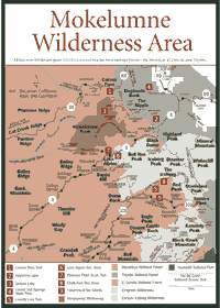 Mokelumne
Wilderness
Mokelumne
Wilderness [Fig. 21] The 9,334-foot Mokelumne Peak stands high above the steep walls of the Mokelumne River canyon. The peak is probably 50 million to 65 million years old, meaning dinosaurs once treaded upon its eroded granite features.
It is not generally a destination for day hikers or the casual visitor in the Mokelumne Wilderness, which spans 105,165 acres and spreads across the Sierra crest to touch three national forests, the Stanislaus, El Dorado, and Toiyabe. But it is characteristic of the steep and primitive landscape that can be seen in this area when hiking the more than 100 miles of trails.
As with many areas in the Central Sierra, the Mokelumne was covered with volcanic eruptions in the past 20 million years and glaciated in the last 2 million years. Glacial moraines dammed lakes in the Bear River-Tanglefoot Canyon area.
On the southern border of the wilderness, just inside the Stanislaus National Forest, is 8,600-foot Mount Reba, the site where a rare fossil was found. This floral fossil dates back about 7 million years and was preserved in the volcanic flows that occurred during a time of faulting and uplifting in the Sierra. Scientists believe the flora in the fossil could only have survived in temperatures colder than tropical weather, which had dominated the Sierra about 33 million years ago. The fossil helps establish that Sierra weather was cooling down from the tropical patterns and slowly approaching the Ice Age that began 2 million years ago.
In the nineteenth century, the Mokelumne Wilderness was used for early emigrant routes of travel from Lake Tahoe to Calaveras Big Trees and for mining and grazing. Other routes slowly became more heavily used in the twentieth century; the area came to be protected as part of the National Wilderness Preservation System in 1964. Boundaries were expanded in 1984.
Besides the Sierra's white fir (Abies concolor) and lodgepole pine (Pinus murrayana) as well as other familiar trees, the Mokelumne has spectacular wildflowers. The selection includes Lemmon's wild ginger (Assarum lemmoni) and the alpine aster (Aster alpigenus). The aster is particularly noticeable with its pink to purple flower head peeking out of mountain meadows in the Mokelumne.
Varieties come and go as the warmer weather begins at lower elevations and moves to the higher elevations in late June, July, and August. In that way, spring seems to be blooming somewhere all through the summer. Such signature western slope flowers as the Sierra lupine (Lupinus grayi) are also characteristic of the dry wooded areas when summer warms up the Central Sierra.
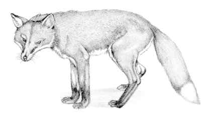
In August around the Mokelumne, such mammals at the gray fox (Urocyon cinereoargenteus) are feeding on manzanita (Arctostaphylos) or coffeeberries (Rhamnus rubra). The fox are active day and night. They are more plentiful and easier to spot than the red fox (Vulpes fulva), which live in the higher elevations, occasionally straying down to about 6,000 feet.
Mokelumne is not known for its lakes as much as it is for its rocks. But Frog Lake, Winnemucca Lake, Round Top Lake, Fourth of July Lake, and Emigrant Lake are considered interesting attractions. The wilderness can be entered from 29 trailheads.
[Fig. 21(1)] Though the wilderness has no roads and motorized travel is prohibited, visitors can see panoramics from several short hikes. All are accessible from Highway 88, which runs east and west just north of the wilderness. On the western side, Highway 88 goes through the El Dorado National Forest; on the east, it passes through Toiyabe National Forest.
 Once
visitors travel beyond the Sierra crest at Carson Pass, vegetation and soils
will change visibly. The east side is drier because of prevailing weather
patterns and the influence of the Sierra itself (see page 203 for
further explanation of Eastern Sierra weather). The soils are more porous.
There are fewer lakes, and plants become sparser, with Great Basin sagebrush
(Artemesia tridentata) dominating the ecosystem.
Once
visitors travel beyond the Sierra crest at Carson Pass, vegetation and soils
will change visibly. The east side is drier because of prevailing weather
patterns and the influence of the Sierra itself (see page 203 for
further explanation of Eastern Sierra weather). The soils are more porous.
There are fewer lakes, and plants become sparser, with Great Basin sagebrush
(Artemesia tridentata) dominating the ecosystem.
On the western side, there are several lakes with glacial histories. Many are easy to reach and provide opportunities to photograph wildflowers, alpine and subalpine plant species. The hikes include Woods Lake trailhead to Winnemucca Lake, Woods Lake trailhead to Round Top Lake near the Lost Cabin Mine Trail, and the Caples trailhead to Emigrant Lake.
An easy-to-find trail, which passes through an area representative of the landscape in the Mokelumne, is the Carson Pass Trail to Winnemucca Lake. As with many trails in California, it is a well-worn route, established without blazes. Along the way, according to U.S. Geological Survey maps, the trail passes directly over a large fault that runs east toward Hope Valley.
Perhaps the first people to use this trail were the various Native Americans who inhabited the area for 10,000 years. The most recent inhabitants, the Miwok from the west slope and the Washoe of the Great Basin, spent the warmer months hunting in the high country and trading with each other.
Explorers such as Jedediah Smith (1826) and John C. Fremont and Kit Carson (1844) were the first Euro-Americans to visit the Mokelumne Wilderness. In 1848, the Mormon Battalion successfully pioneered a trail just south of present day Carson Pass in a trek from Sutter's Fort to Salt Lake City, and later, thousands of emigrants followed this route on the way to the gold fields of California. Shepherds later grazed stock in the spring and summer.
[Fig. 21(2)] Take two or three days to enjoy a hike along the Pacific Crest Trail to Raymond Lake, passing volcanic pillars, domes, and all kinds of streams. But be careful. This trail crosses Highway 4 near Ebbetts Pass. That's probably about as much danger as most hikers will see.
The trail passes Upper Kinney Lake, Pennsylvania Creek and Reynolds Peak before reaching Raymond Canyon. The up-and-down hike at this elevation—mostly over 8,000 feet—will make most backpackers sleep at night. Small campsites are available at Raymond Lake.
[Fig. 21(3)] For those who do not want to put in an eight-hour day to complete this hike, there are campgrounds all along this trail. Whether you camp or day hike, the trip to this tarn is an eventful route filled with meadows and subalpine vegetation.
After crossing three basins and ascending a rocky ridge, the views of the Mokelumne Wilderness are stunning. The ridge tops out at more than 9,000 feet, but the reward is a swift descent to the lake and campsites at 8,400 feet where the Sierra air is a little thin but definitely clear.
[Fig. 19(5)] In the foothills west of the El Dorado National Forest, there are 1,185 grinding holes in outcroppings of marbleized limestone made by Native Americans who lived here for many centuries and still live here today. It is the largest collection of bedrock mortar holes found anywhere on a single stone in North America.
The Miwok Indians pounded acorns from the abundant valley oak (Quercus lobata), the stately California oak that grows to 9 feet in trunk diameter and has wide, drooping branchlets. The tree, which is found on the Sierra's western slope below 4,000 feet, provides acorns to the California woodpecker (Melanerpes formicivorous). The flora include a number of flowering plants, such as the monkey-flower (Mimlus torrey), white mariposa lily (Calochortus venustus), and Sierra iris (Iris hartwegii).
In the surrounding woodland near this valley, visitors can hear the calling of a hermit thrush (Catharus guttata) nesting in the nearby foothills. The thrush, like many birds of the wooded foothills, prefers living near the ground under a canopy of leaves. The 135-acre park has many bird species, much as it did when the Miwok first inhabited it.
To the Miwok, the place is known as Chaw'se, the pounding stone. The Miwok would slowly pound seeds and acorns into meal, leaving the distinctive cup-shaped impressions that survive today. The Miwok's daily activities here included weaving baskets, making flour from acorns, and processing other plants for food, fiber, and medicines. Along with all those mortar holes, there are many decorative carvings in the rock—spokes, human tracks, wavy lines. These petroglyphs are thought to be 2,000 to 3,000 years old. This is the only place where such mortar holes and petroglyphs occur together.
The marbleized limestone rock is quite fragile and susceptible to breaking and fracturing with time and weathering. Many petroglyphs are fading, and visitors in future generations will not be able to see this historic artwork.
Read and add comments about this page