 Lee
Ranger District Lee
Ranger District
Lee
Ranger District Lee
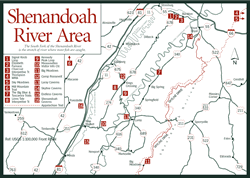
Ranger District [Fig. 25] The Lee Ranger District, the northernmost district of the George Washington National Forest, is divided into two tracts with the Shenandoah Valley and the towns of New Market and Woodstock between them. Remnants from the colonial era, the Civil War, and the CCC construction following the Great Depression open windows to the area's rich history. Several recreation areas offer base camps for learning the history and exploring nearly 300 miles of trails that lead into 189,082 acres of national forest. Residents of Washington, D.C., who are just a couple of hours away from the district, are frequent visitors.
A large, scenic portion of the western tract is in West Virginia, extending almost to WV 259. The western part of Shenandoah County, including North Mountain, Little Sluice Mountain, Little North Mountain, and Paddy Mountain, comprises most of the Virginia part of the western Lee District.
Tucked into the beautiful mountains and streams of Hardy County, West Virginia, is newly renovated Trout Pond Recreation Area, with opportunities for camping, fishing, boating, swimming, and hiking. The area has 17-acre, 45-foot-deep Rockcliff Lake with stocked trout, a swimming beach, and space for canoes and small boats. Trout Pond, the 2-acre, 35-foot-deep natural lake that gives the recreation area its name, is an interesting phenomenon in a landscape riddled with sinkholes and depressions.
The popular eastern tract of the Lee District occupies the slopes of 50-mile-long Massanutten Mountain which rises from the northern Shenandoah Valley north of Harrisonburg and east of Interstate 81. VA 211 runs east-west across the mountain, connecting the towns of New Market on I-81 and Luray on US 340. Elevations on the mountain range from 800 feet to 3,300 feet. Predominate rock formations consist of easily eroded Martinsburg shale and limestone often capped with more resilient Massanutten sandstone. The Massanutten Visitor Information Center [Fig. 30(10)] is on VA 211 where the road crosses Massanutten Mountain.
The serpentine North Fork and the South Fork of the Shenandoah River border Massanutten Mountain on the west and the east, respectively, adding excellent smallmouth bass fishing and peaceful canoe float trips to the district's attractions. Also, in the heart of Massanutten Mountain, north of the visitor center, is a bowl of private land called Fort Valley. VA 678 runs north-south through this quiet valley of farms and forests where mountains keep modern civilization at bay. Look for signs along Passage Creek denoting stocked trout waters.
Elizabeth Furnace and Camp Roosevelt offer mountain recreation in the eastern Lee District, while High Cliff Canoe Camp provides a pleasant stopover for boaters on the South Fork of the Shenandoah River. Backcountry camping is permitted anywhere on national forest lands, except where posted. Both the western and eastern tracts of the Lee District have a nearby resort. To the west is Bryce Resort, offering snow skiing, grass skiing, golf, tennis, horseback riding, and swimming. It's located at Bayse on the eastern slope of Great North Mountain west of Mount Jackson. To the east is Massanutten, on the southern end of Massanutten Mountain, offering day and night skiing and snowboarding. Guided horseback trips and cabin rentals are available from Fort Valley Stable.
Two ATV (all-terrain vehicle) trails—Peters Mill Run and Taskers Gap—are located southeast of Edinburg, near the ranger district office. All trails except interpretive trails are open to mountain bikers and equestrians, though rocky terrain and steep inclines make some trails too difficult.
The mountains yield a wealth of wildflowers. Common plants to look for in the woods, at the edge of the woods, and along streams include bloodroot (Sanguinaria canadensis), large-flowered trillium (Trillium grandiflorum), spotted touch-me-not (Impatiens capensis), common blue violet (Viola papilionacea), spiderwort (Tradescantia virginiana), wild columbine (Aquilegia canadensis), and wood vetch (Vicia caroliniana), one of our few native vetches. Along the roads and fields are sprinklings of blues, yellows, and mauves—blues from chicory (Chicorium intybus) and bachelor's button (Centaurea cyanus); yellows from black-eyed susan (Rudbeckia hirta), common mullein (Verbascum blattaria), and tickseed sunflower (Bidens aristosa); and mauves from spotted joe-pye-weed (Eupatorium maculatum) and wild bergamot (Monarda fistulosa).
Wildlife of the Lee Ranger District includes the black bear, white-tailed deer, red and gray fox, bobcat, gray squirrel, ruffed grouse, and wild turkey. Several species of owls, including screech, barred, barn, and great horned, will add their mysterious hoots to a quiet summer night. The tiny saw-whet owl—no taller than a pencil—is an occasional winter visitor. Though rarely spotted during the daytime, this nocturnal owl is easy to approach. Birds typical of Appalachian woodlands, such as vireos, thrushes, tanagers, warblers, nuthatches, flycatchers, and sparrows make birdwatching rewarding. In September and October, birds of prey can be spotted soaring along the ridgelines.
[Fig. 30(10)] Located at the southern end of Massanutten Mountain on US 211, the center is a good place to begin exploring the eastern Lee District. From mid-April through mid-November, staff is available to answer questions and provide information on forest activities and recreation opportunities. The center stocks a complete line of environmental education books, field guides, fishing and hiking publications, and numerous maps of the district and the entire George Washington and Jefferson National Forests.
Trailheads for two interpretive trails—Discovery Way Trail and Wildflower Trail—are at the visitor center. The self-guided Discovery Way Trail begins just south of the parking lot. This .2-mile paved path is handicapped accessible. Discoveries the hiker makes include a rock with living skin, an Indian toothbrush, and tea trees.
The .5-mile Wildflower Trail begins on the east side of the parking lot and connects the visitor center with the New Market Gap picnic area and with the 24.5-mile Massanutten Mountain Trail. The path retraces Confederate General Stonewall Jackson's footsteps during his famous Shenandoah Valley campaign of the Civil War.
From mid- to late May, pink lady slippers put on a showy display under the tree canopy along the trail and at the picnic area. Even botanists are often stumped in figuring the complex factors that allow a plant to thrive in one place and not another. John Coleman, district ranger, speculates that something as simple as a subtle increase in light when deadwood was cleared resulted in perfect conditions for the lady slippers. Visitors are asked to leave these endangered flowers for others to enjoy.
North of the visitor center on FR 274 are two more interpretive trails—the paved .3-mile Massanutten Storybook Trail (handicapped accessible) and the Lion's Tale Trail (soon to be handicapped accessible). The Storybook Trail is 1.5 miles north of the visitor center and the Lion's Tale Trail is 8 miles north, just south of Camp Roosevelt.
[Fig. 30(12)] "The Army With Shovels," as the Civilian Conservation Corps (CCC) came to be known, began its work by establishing Camp Roosevelt in 1933. President Franklin D. Roosevelt, who mobilized this vast supply of willing manpower in March of 1933 during the Great Depression, was on hand for the dedication of this first of 1,500 camps across the United States.
Located on VA 675, 9 miles north of the Massanutten Visitor Information Center, the site that once served as a base of operations for the first CCC men now provides campers, picnickers, and hikers a base for exploring Massanutten Mountain and Fort Valley. Some of the original construction remains. The CCC worked to control floods and erosion, planted trees, fought forest fires, and built roads, trails, bridges, and recreation areas. The Lion's Tale National Recreation Trail [Fig. 30(8)] is about 1 mile south of the recreation area on FR 274.
[Fig. 30(2)] At the northern end of Massanutten Mountain is Elizabeth Furnace, where iron ore was melted down more than 150 years ago. A 30-unit family campground and 54-site picnic area with two shelters are located here. Several trails, including the Pig Iron Interpretive Trail, radiate from the area. This easy .25-mile loop passes the remains of Elizabeth Furnace and describes the pig iron industry of the nineteenth century. Passage Creek, which flows through the area, is stocked with trout by the Virginia Department of Game and Inland Fisheries.
[Fig. 30] With 75 blazed trails covering nearly 300 miles, the Lee Ranger District is a natural for hikers, bikers, cross-country skiers, and equestrians. The hikes range from short, easy interpretive trails to long treks over rough terrain more suitable for backpackers. The western portion of the district gets lighter use than the eastern portion.
Lion's Tale Interpretive Trail. [Fig. 30(8)] This .5-mile rope-guided loop has a surface of crushed limestone. This trail is handicapped accessible.
Charcoal Interpretive Trail. [Fig. 30(3)] Beginning at the Elizabeth Furnace Picnic Area, this easy, .5-mile trail describes the charcoal industry, an outgrowth of the pig iron industry. The Pig Iron Trail adjoins Charcoal Interpretive Trail at .25 mile.
Signal Knob Loop. [Fig. 30(1)] This strenuous 10.2-mile hike combines four trails to make a loop, leading to an important Union and Confederate outpost during the Civil War. Overlooks into both the Shenandoah Valley and Fort Valley demonstrate the importance of Fort Valley as a place to protect and hide troops during the Civil War. Hikers can enjoy the pinks and whites of azalea, mountain laurel, and dogwood in spring. Blueberries ripen along the footpath in late summer. The four trails are Signal Knob (yellow blaze), Massanutten Mountain West (orange blaze), Bear Wallow (blue blaze), and Bear Wallow Spur (white). The trailhead is at the Bear Wallow/Signal Knob parking lot on VA 678 about 1 mile north of the Elizabeth Furnace picnic area.
Kennedy Peak Loop. [Fig. 30(9)] This moderately strenuous 5.4-mile loop climbs to an observation tower with beautiful views of Page Valley to the east of Massanutten Mountain. Begin the hike at Edith Gap, heading north on the Massanutten Mountain East Trail (orange blaze). At 2.4 miles, take the white-blazed spur .3 mile to the observation tower.
Mill Mountain Trail to Big Schloss. [Fig. 30(6)] Wolf Gap, a primitive campground with 10 heavily wooded sites, can be used as a base for this popular hike in the western portion of the Lee Ranger District. The reward for the moderate 2-mile (one-way) climb along the ridge of Mill Mountain is Big Schloss, a picturesque area of huge rocks with panoramic views into Trout Run Valley in West Virginia and views of Little Schloss Mountain and Great North Mountain in Virginia. The free campground at Wolf Gap is open all year and used only lightly. Tables, pit toilets, and a hand water pump are provided.
Read and add comments about this page