 River
Valleys: New River River
Valleys: New River
River
Valleys: New River River
Valleys: New River [Fig. 50, Fig. 46(50)] At 350 million years old, the New River is hardly "new" at all. In fact, many geologists believe the New is second only to the Nile as the oldest river in the world. In prehistoric times, the river flowed north to the St. Lawrence River on the United States border with Canada.
During the Ice Age, glaciers carved up the New River, diverting it into the Ohio and eventually the Mississippi. The New River is also one of the few major rivers in the world to flow north. All other major waterways in this section of Virginia flow either south, east, or west, and thus take a more direct path to the Chesapeake Bay or the Gulf of Mexico. The New River is on of the few rivers in North America to flow south to north, and the only river to cut through the entire width of the Appalachian Mountains.
Because of the outstanding mountain and pastoral backdrops and the uncommonly clear waters that support a healthy ecosystem, the New River is ideal for boating, fishing, swimming, and snorkeling. Besides several varieties of fishes, the river teems with freshwater mussels and sponges, crayfish, salamanders, and snails. Raccoons leave little piles of shells where they've eaten mussels at water's edge. Ducks nest in roots and tree hollows along the banks and up in grassy creeks and marshes. Red-winged blackbirds make nests where there are cattails and reeds.
The North and South forks of the river converge on the Ashe and Alleghany county line in North Carolina, just south of Grayson County, Virginia. The river flows into Virginia near a tiny community called Mouth of Wilson, a southern gateway to some of Virginia's most spectacular mountain scenery in Mount Rogers National Recreation Area and Grayson Highlands State Park. The ancient New then begins its extraordinary 160-mile journey through Virginia and into West Virginia.
As it flows north, the river alternates between wild forests and languid farmlands. In keeping with the habit of rivers, the New follows a scenic path seldom seen by travelers on highways and byways. In passing through the Blue Ridge Mountains, it picks up New River Trail State Park, which follows it from Fries at the Grayson-Carroll county line north to the backwaters of Claytor Lake.
Claytor Dam, south of Interstate 81 and Radford, temporarily holds back the river while the Appalachian Power Company harnesses its energy. Then the New meanders north on the second half of its passage through Virginia, slips under Interstate 81, and forges through several mountain ranges of the Valley and Ridge province.
The river adds its beauty to the George Washington and Jefferson National Forests, squeezing between Walker and Sinking Creek mountains at the corner of Giles, Pulaski, and Montgomery counties. The New cools the feet of hikers on the Appalachian Trail west of Pearisburg, passes through a gap called the Narrows, and hails Peters Mountain Wilderness to the northeast as it leaves the state in the western tip of Giles County.
Native American tools and artifacts found in the New River Valley suggest that hunting forays took the Indians throughout much of this naturally rich country as far back as 10,000 years ago, though evidence of permanent Indian settlements in the area is inconclusive.
European settlers, however, came, liked what they saw, and made themselves at home. In the last half of the 1700s, immigrants from Scotland, Ireland, England, and Germany walked or rode wagons and ox carts down the Great Valley. They came upon the mountains and streams and rich farmland and foggy mornings, and decided this area resembled the Old Country, so the settlers began spreading out, establishing homesteads and then forts to run to for safety.
Shawnee and Cherokee raiding parties regularly attacked the Europeans and tried to drive them out. Such dangers on the frontier reduced European immigration to a trickle during the French and Indian War and the American Revolution, but once peace could be assured, the wagons, horses, livestock, and people began a steady stream into the New River Valley. There was much to do and see.
Abundant food and fresh water were available. The New River and hundreds of nearby tributaries offered an additional source of food and a cheap and dependable supply of water-related energy for floating cut timber, grinding grains, making charcoal, tanning hides, and mining lead and iron. Mining and milling would all but disappear in the New River Valley in the early and mid-1900s, but manufacturing and service industries—and especially tourism—would fill the vacuum created when the rustic tanning of hides and the mining of saltpeter were no longer in demand.
The largest whitewater river in Virginia, the New offers challenges for all skill levels. However, until it enters West Virginia, it is mostly suited to those who enjoy a leisurely float through mountain passages and pastoral countryside. With many put-in sites, the river is ideal for those who like to leave a second car at a take-out point downriver and float the river in sections, perhaps camping along the way. Portages are required at Mouth of Wilson, Fries, Byllesby, and Buck dams.
There are numerous riffles and Class II and III rapids that will make an angler put down his rod and pick up a paddle in the upper section. In the lower river, north of Claytor Lake, some stretches are flat and require considerable paddling. Except during periods of high water, though, the river is best suited for novices and intermediate paddlers until it enters West Virginia, where its whitewater is renowned. There, the river changes character as it tumbles through the canyons of New River Gorge, creating serious rapids of Class III to Class V.
Outfitters in Virginia and West Virginia are ready to take visitors fishing, canoeing, tubing, or whitewater rafting. Some are listed here, or travelers can call local chambers of commerce for more information. For visitors who have their own craft, a state gazetteer will help locate the many boat landings spread along the river. Visitors should be prepared for sudden rises in water level when dam releases occur.
For more information: New River Trail State Park (canoe and inner tube rentals), Route 2, Box 126 F, Foster Falls, VA 24360. Phone (540) 699-6778 or (540) 236-8889. New River Adventures (based at Foster Falls), 1007 North Fourth Street, Wytheville, VA 24382. Phone (540) 228-8311. Allisonia Trading Post, HCO2 Box 15 B, Allisonia, VA 24347. Phone (540) 980-2051. Cliffview Trading Post, Route 4, Box 163, Galax, VA 24333. Phone (540) 238-1530. New River Canoe Livery, Pembroke, VA. Phone (540) 626-7189.
The largest smallmouth bass, walleye, and muskellunge ever caught in Virginia came from the New River. The bass weighed 7 pounds, 7 ounces; the walleye was 14 pounds, 2 ounces; and the muskie weighed 45 pounds. The New has a deserved reputation for producing citation (trophy) smallmouth, especially in the spring. In early 1997, a four-year-old (with Granddad's help) reeled in a 7-pound, 2-ounce smallmouth from the Giles County portion of the river.
In 1995, more trophy muskie—including one 36-pounder—came from the New than from any other body of water in the state. The fish are stocked from the North Carolina line to Fries Dam (southern trailheads for New River Trail State Park) and from Claytor Dam to the West Virginia line. Most are caught below Claytor Dam and downstream. Walleye run up the river out of Claytor Lake as early as January, as do white bass in April and May. Below Claytor Dam, look for walleye, stripers, white bass, catfish, largemouth bass, and rock bass.
Other varieties of fish that may hit your bait include redbreast sunfish, spotted bass, log perch, common carp, whitetail shiner, and channel catfish. Anglers or boaters below Claytor Dam must watch for water releases from the dam when electricity is being generated. The river level can rise dramatically and trap those riding in boats, fishing from rocks, or wading.
For more information: Virginia Department of Game and Inland Fisheries, 4010 West Broad Street, Richmond, VA 23230-1104. Phone (804) 367-1000.
[Fig. 17(2), Fig. 50(7)] Almost 200 years old, this fortresslike stone tower provided a complex but effective way to make lead shot for frontier hunters and adventurers and for the Confederacy during America's Civil War. The problem was how to make the shot perfectly round. Designers figured they could drop bits of hot lead from a height and it would cool into round balls as it fell. But two problems arose. One, wind currents could make the balls spin and cool unevenly. And two, the cooling lead would flatten when it hit bottom.
Thus the Shot Tower, which stands 75 feet high, with stone walls that are 2.5 feet thick. Beneath the floor of the tower, another 75-foot shaft was dug straight down by hand. The lower vertical shaft stopped just above river level, with a horizontal tunnel that led to the river.
In the top of the tower, 150 feet above the river level, molten lead was poured through porous sieves that shaped the projectiles. Tiny globs of hot lead in a 150-foot free-fall cooled uniformly, and were cushioned by a kettle of water at the bottom. Few of these old shot towers have survived wars, floods, and the ravages of time. Following renovation in 1968, the New River Shot Tower was designated a National Historic Mechanical Engineering Landmark by the American Society of Mechanical Engineers.
[Fig. 50, Fig. 32(50)] From the beginning, rivers have fascinated people. They settle beside them and plant crops, yet harbor a yearning to check out a river's receding twists and turns and to find out what might lie beyond the next canyon.
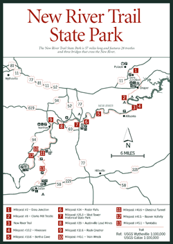
Few places offer as much opportunity to hike, bike, or ride horseback alongside a major river as does the stretch of abandoned railroad bed that is now New River Trail State Park. Keeping perfect contact with the sinuous journey of the ancient New River and Chestnut Creek and the upper end of Claytor Lake, New River Trail State Park is 57 miles long, but only 80 feet wide. The path itself is 10 to 12 feet wide.
Several descriptive names are used to describe these long, skinny parks, including "linear park," "greenway," and "rails-to-trails park." The New River Trail is another example of the rails-to-trails plan to convert abandoned railroad to trail systems (see Rails-to-Trails Program). This one, created in 1987, features 28 former railroad trestles (now resurfaced to accommodate trail users) across tributary streams, three bridges that span the New River, and two 200-foot-long tunnels. With the unusual geologic features and history along the trail, not to mention the many opportunities for recreation, wildlife watching, and good fishing, the 55 miles of trail now open attract an increasing number of visitors each year.
Resident waterfowl along the park include mallards, wood ducks, American coots, Canada geese, great egrets, great blue herons, and little green herons. White-tailed deer drink from the river and its tributaries. Wild turkeys scratch in leaves along the banks. Beaver cuttings can be seen along the trail. Gray squirrels that live in trees along the river are not as wild—or wary—as those less accustomed to people.
Rivers are habitat for various reptiles and amphibians. A water snake may swim out from the edge as hikers pass, and head for the opposite bank. An occasional prehistoric-looking snapping turtle will watch with beady eyes from a safe distance.
Where tall weeds grow in a sunny field by the river, American goldfinches pick seeds from dried thistle stalks. The bright yellow males with black cap and wings are easy to spot. As evening settles on the riverbank, listen for the quiet call of robins in tall sycamores.
The east end of the expansive Mount Rogers National Recreation Area (NRA) borders the river on its west bank between Buck and Byllesby dams. Camping is available at New River Campground and Picnic Area here. This part of Mount Rogers NRA is not well known and therefore offers a better chance for solitude. A 2-mile stretch of the New River Trail between Lone Ash and Barren Springs in Wythe County is closed indefinitely.
The New River Trail also offers public access points for canoeing, kayaking, and fishing. Check park headquarters at Foster Falls for a free map listing access points and features along the riverside trail. The park rents canoes, bicycles, and inner tubes.
Theoretically, following the New River north in the direction of its flow means walking downhill. For all practical purposes, however, the walk is level where it follows the river. At the northern end (milepost 8), the trail leaves the river and follows the old railroad bed, which heads on a more uphill course for Pulaski.
Starting from the two separate southern trailheads—the first at Galax on the Chestnut Creek tributary and the other at Fries on the river—here are a few highlights and the mileage as it relates to the old railroad mileposts (many still in place):
Mile 45.1: (at Chestnut Yard entrance). [Fig. 50(13)] Turntable. Look for the remains of the old platform turntable half buried in the clearing. Turntables were used to switch an engine from one direction to another.
Mile 41.5: (north of Fries entrance). [Fig. 50(12)] Beaver sign. Look along the river bank for trees felled by beavers. The cone-shaped stumps have the telltale grooves of the rodent's strong teeth. Large denning holes may also be found among the sycamore roots along the bank.
Mile 40.6: (north of Gambetta entrance) Chestnut Tunnel. [Fig. 50(11)] This 195-foot tunnel carved from rock is one of two on the trail.
Mile 40.1: (north of Fries entrance and just south of connection with Galax Trail). [Fig. 50(10)] Train wreck. In 1928, a passenger train and freight train collided at this spot, killing 3 and injuring 7 of 11 people aboard.
Mile 31.6: Rock crusher. [Fig. 50(9)] The 1901, 40,000-pound Allis-Chalmers rock crusher here once ground large slabs of limestone into smaller pieces for a local quarry.
Mile 29: Austinville Lead Mines. [Fig. 50(8)] Once lead was discovered here in 1756, the mining of minerals began in earnest. Most of the lead for the Revolutionary War and later for the Civil War came from the Austinville Lead Mines. Later the mine produced zinc, then limestone. When the mines closed in 1981, after operating continuously for over 200 years, they were among the oldest in the nation.
Mile 25.3: Shot Tower Historical State Park. [Fig. 50(7)] Built about 1807, the shot tower provided a method of dropping lead mined from the Austinville mines a distance great enough to cool it as it formed a round shape.
Mile 24: Foster Falls (Park Headquarters). [Fig. 50(6)] Foster Falls is being developed as the park headquarters and central recreation area for the park. The historic Foster Falls village includes a depot, hotel, sawmill/gristmill, and iron furnace. The Foster Falls Depot next to the trail and the abandoned Foster Falls Hotel off the trail are visible reminders of the now-defunct community and Hematite Iron Company that once depended on the railroad. Hematite is an important iron ore. In fact, the small mountain across the river from the trail is named Hematite Mountain and is an extension of the Iron Mountains to the west. The mountain to the east on the trail side of the river is Foster Falls Mountain, named for the impressive rapids here and for early landholder William Foster.
Mile 19.6: Bertha Cave. [Fig. 50(5)] Resist the temptation to disturb this 100-foot-deep cave, where a colony of bats depends on isolation from humans. Water percolating through porous limestone rock formed this and thousands of other Valley and Ridge caves.
Mile 10.2: Hiwassee. On the east side of the river near the Hiwassee Bridge is the town of Hiwassee, once a busy mining town. Hoover Mining Company, started in 1920, is the only remaining mining company in Pulaski County. The company still mines three natural iron oxide ores—ochre, umber, and sienna, used to make 300 different pigments.
Mile 8: Clarks Mill Trestle. [Fig. 50(2)] Underneath the trestle—and under the water backed up by the Claytor Lake Dam—are the remains of an old mill. The railroad bed leaves the New River at this point and heads for Pulaski.
Mile 2: Dora Junction. [Fig. 50(1)] Named for nearby remains of Dora Furnace, this junction is the northern trailhead for New River Trail State Park.
The trail is accessible at Hiwassee, Allisonia, Austinville, and Lone Ash, where there are no developed parking areas. Listed below are access points with parking areas:
Fries trailhead and boat launch (eastern Grayson County near Carroll County line): In Galax, from US 58 bridge over Chestnut Creek, go east approximately .5 mile and turn left (north) on VA 887. Go about .5 mile and turn left on Cliffview Road (VA 721). Go 5.8 miles to Fries. Parking is available near the town park and caboose.
Galax trailhead (on Carroll and Grayson county line): Park where US 58 crosses Chestnut Creek, just south of junction with VA 97.
Cliffview: In Galax, from US 58 bridge over Chestnut Creek, go east approximately .5 mile and turn left (north) on VA 887. Go about .5 mile and turn left on Cliffview Road (VA 721). Parking area is on left, across from Cliffview Mansion and Cliffview Trading Post.
Gambetta and Chestnut Yard: Follow directions to Cliffview and continue along VA 721. Turn right on VA 607 and go about 3 miles to Chestnut Yard. Or, after right turn on VA 607, go 1.5 miles and turn left on VA 743, continuing about 2 miles to Gambetta.
Byllesby Dam: From VA 94 in western corner of Carroll County, take VA 602 east about 3 miles to river.
Buck Dam: Follow above directions to Byllesby. Take VA 737 north to Buck Dam.
Ivanhoe: At Ivanhoe, in Wythe County, next to western corner of Carroll County, from VA 94, take VA 639 1 block east to river.
Shot Tower Historical State Park: From I-77 in southeastern Wythe County, take Exit 24 and go east .2 mile on VA 69 to VA 52. Go left and travel 1.5 miles on VA 52 to Shot Tower entrance, on left.
Foster Falls (Park Headquarters): Follow directions to Shot Tower, above. From VA 52, turn right on VA 608 and follow signs 2 miles to park.
Draper: From I-81, take Exit 92 and follow VA 658 east through Draper. Park across from Bryson's Store, less than 1 mile from interstate.
Pulaski/Xaloy trailhead: From I-81, take Exit 94B and go north 1.9 miles on VA 99 to Xaloy Drive. Turn right and go 100 yards to trailhead.
 Claytor
Lake and Claytor Lake State Park
Claytor
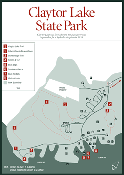
Lake and Claytor Lake State Park Claytor Lake. [Fig. 51)] If the bottom of clear, cold, deep, 21-mile-long Claytor Lake was visible, visitors would get a glimpse of one link on the chain of history connecting white settlement along the frontier area known as southwest Virginia. The 4,475-acre impoundment of the New River lies south of Radford and east of Pulaski in Pulaski County, an easy jump from Interstate 81.
The nearby interstate and US 11 follow closely the old Wilderness Road, a footpath and wagon trail for settlers traveling south down the Shenandoah and Roanoke valleys from Pennsylvania. Thousands of years before European pioneers started streaming down the valley in the mid-1700s, the road was a well-traveled hunting and raiding route used by southern Cherokee and Catawba tribes, as well as members of the northern Iroquois Confederacy of Five Nations. A mystic German sect called the Ephrata Brethren—later to be known as Dunkards—decided the land now covered by Claytor Lake was the place they wanted to stop. When the New River was dammed to form Claytor Lake for the generating of electric power in 1939, the community known as Dunkard's Bottom was swallowed by the rising waters.
Fishing at Claytor Lake. Fishing is good but challenging in the narrow, winding waters of the lake. Claytor's steep shorelines make excellent habitat for smallmouth and spotted bass. In 1993, a 3-pound, 10-ounce spotted bass caught in the lake took the state record.
Good-sized largemouth bass come from Peak Creek, which branches off the upper river due east of Pulaski. Schools of striped bass in the 8- to 14-pound range occasionally produce a fish exceeding 20 pounds. Muskie, walleye, crappie, white bass, and catfish also bend anglers' rods at Claytor. Because there's so much water to cover, electronic fish-finding equipment can be a welcome aid.
Claytor Lake State Park. With 472 acres of mostly hardwoods and pines, Claytor Lake State Park is now the centerpiece of 21-mile-long Claytor Lake. The park is a magnet to some 300,000 people a year whose primary recreational interests are waterbased.
Actually, the park and lake can get quite crowded on summer weekends. Much of the park property, however, is woodland, so getting away from the whine of bass boats and jet skies is no difficult matter.
As sought-after as this park is on a hot summer day, winter visitors have it mostly to themselves. An occasional hiker or runner and maybe a couple reminiscing about last summer's family reunion at the park will be there to give them a smile and a nod.
The park's visitor center [Fig. 51(8)]—a handsome, old, brick home located beside Claytor Lake—is historic. Haven Howe, a prominent Pulaski County citizen and Civil War cavalryman, built the home in 1879 using logs cut and dragged from the surrounding forests and bricks kiln-dried on the site. Howe was also a master craftsman. Visitors today still admire the freestanding staircase Howe built inside the house, the hardwood moulding he designed, and the wide pine floor he laid more than 100 years ago. Howe was also an environmentalist before the word was coined. He spent a great deal of time trying to reduce or halt tailings dumped in his beloved New River by iron-ore smelting plants in the region. The hard existence of early settlers is one topic of the visitor center exhibits. New exhibits focus on the lake's fish and water quality, and the park's animal life.
In summer, a full-service marina sells bait and tackle and manages a boat launch, motorboat and rowboat rental, and boat mooring at a floating dock. Evening programs draw guests to the lakeside amphitheater, The Gazebo.
Accommodations include four campground loops varying from densely wooded to sparsely shaded, to more open sites. There are also 12 lakefront rental cabins. Reservations, especially for peak season, should be made well in advance. A family fishing tournament and lake cleanup is held in June. On Labor Day weekend, patrons of the Claytor Lake Arts and Crafts Festival stroll among canopied booths shopping for baskets, pottery, handcrafted musical instruments, and oil paintings.
Before making a trip solely to take a luncheon or dinner cruise on the Pioneer Maid, travelers should call the office. The cruise is no longer available, but the state is investigating alternatives for this once-popular attraction. The double-deck, 600-foot boat sank, and protecting the clear lake waters from its diesel fuel became an expensive undertaking for the owners.
 Hiking
Trails at Claytor Lake State Park
Hiking
Trails at Claytor Lake State Park Three trails totaling 4 miles wind through the oak-hickory forest and conifer stands of the park. The former horse trail was regraded and is now a hiking trail.
Shady Ridge Nature Trail. [Fig. 51(3)] Beginning at the picnic area with a brief steep climb, the red-blazed trail then levels off for an easy .6-mile guided loop. Tall pines and cedars alternate with shrubby fields. A stand of large Carolina hemlocks is a highlight. Where old trees lie decaying on the ground, life replenishes itself. Bacteria, insects, and woodpeckers help the process along, until finally the tree is fully decomposed. Mushrooms, mosses, and new sprouts thrive in soil enriched by the decay.
Claytor Lake Trail. [Fig. 51(1)] Tulip poplar, hickory, red and white oak, black locust, and sycamore shade this blue-blazed, 1.6-mile trek through Claytor Lake's hardwood forest. The trail includes several lake views and is accessible across the road from the marina parking lot, from campground loops C and D, and across the road from the cabins.
Read and add comments about this page