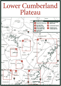
The lower Cumberland Plateau section is bracketed on the north by I-40, on the west by the plateau's irregular western escarpment, on the east by I-75, and on the south by the Alabama and Georgia state lines. The one exception is the part of Lookout Mountain that extends into Georgia. The Lower Cumberland Plateau includes all or parts of Putnam, White, Cumberland, Van Buren, Bledsoe, Grundy, Franklin, Marion, Sequatchie, Hamilton, Rhea, Meigs, Roane, McMinn, Loudon, and Bradley counties.
The Savage Gulf in the southwestern part of the Cumberland Plateau has the only large virgin tract of typical mixed mesophytic forest in Tennessee. It more closely resembles forests of the northern Cumberland Mountains. This virgin tract of between 1,500 and 2,000 acres was not harvested because of some right-of-way disputes. This is one of the largest virgin tracts in the southeastern United States. In this area are the endangered white fringed orchid (Platanthera integrilabia) and Wood's false-hellbore (Veratrum woodii).
The most significant feature in the lower portion of the plateau is the Sequatchie Valley, the ruler-straight cleft that bisects the region in Tennessee and extends on into Alabama. The valley is special from a geologic standpoint because it may be the longest and straightest in the world, but it is also important because it subdivides the southern part of the plateau. All of the area west of the valley is referred to as the Cumberland Plateau, but the area to the east is known as Walden Ridge, named after Elijah Walden, one of the longhunters of the Boone era.
The Sequatchie Valley was created during the mountain-building period about 270 million years ago by an overthrust system that pushed rock from the southeast over rock to the northwest. The overriding rock was folded into a gigantic anticline, or arch, the northern part of which is still intact and visible as the Crab Orchard Mountains. The rest of the rocks located southwest of the arch, however, were so fractured that they were easy prey to erosion. The Sequatchie River was able to scoop out the 5-mile-wide Sequatchie Valley.
Unlike most of the land on the plateau, the Sequatchie Valley contains very rich soil, yet the economic boom that began in 1870 and ended with the economic depression of 1893 resulted mainly from the exploitation of the coal, lumber, and iron in the area rather than agricultural products. Several towns sprung up in response to this activity: Pikeville, Dunlap, Whitwell, Kimbal, Victoria, and South Pittsburg. The latter town became the site of a cement factory and a foundry, which helped the area experience some economic recovery during the early part of the century.