 Cataloochee
Valley Cataloochee
Valley
Cataloochee
Valley Cataloochee
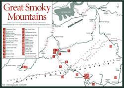
Valley [Fig. 43(14)] The Cataloochee Valley is one of the most remote, and therefore least visited, parts of the Great Smoky Mountains National Park. The area is of a rural rather than wilderness nature, having once supported a close-knit family community of 1,200 residents, some of whom lived in the valley as recently as the 1960s. The valley's pastoral roots are evident in several old buildings, including a school, a church, and a number of former homes and barns. The name Cataloochee is derived from the Cherokee phrase god-a-lu-chee, which generally translates into English as "wave upon wave of mountains" and refers to the distant views of the region as seen from the higher mountain peaks.
The Cataloochee drainage basin is defined by the Balsam Mountain Range which extends along the western border north to Tricorner Knob at the Smokies Crest. The Mount Sterling Ridge, north of the valley, and the Cataloochee Divide on the southeast, both extend from the Balsam Range to form additional boundaries.
The area provides access to a number of hiking and horse trails and the Cataloochee Primitive Campground, which includes 27 campsites. There is also a ranger station, located in what was formerly a home, built in 1916 from chestnut beams and paneling. An old church graveyard lies on a hill on the right just past the Palmer Chapel and puts on a showy display of pink lady slipper (Cypripendium acaule) in the spring.
Thirty-seven miles of trails course through Cataloochee Valley, including the popular Boogerman Loop, Rough Fork Trail, and Cataloochee Divide Trail. Cataloochee Creek, Caldwell Creek, and Palmer Creek offer excellent fishing opportunities, subject to park regulations.
[Fig. 43(11)] As Big Creek drops more than 1,200 feet on its way toward its confluence with the Pigeon River, it creates one of the most beautiful watersheds in the Great Smoky Mountains National Park. The creek is noted for its effervescent cascades, whitewater falls, and excellent fishing opportunities. Brown trout (Salmo trutta) and rainbow trout (Oncorhynchus mykiss) are visible in its clear, cold waters. The native brook trout (Salvelinus fontinalis) lives here as well, but it is illegal to fish the native species.
Like so many areas of these mountains, logging operations made camp in Big Creek early this century. From 1908 to 1918, the Crestmont Lumber Company established homes, a school, and a mill here before depleting the mighty timber. (Trees once grew to diameters as large as 10 to 12 feet.) In the 1930s, the CCC made camp here, improving roads and trails in the area. Big Creek Trail is the main trail in the area, connecting with several other side trails. The 5.8-mile trek (one-way) starts at Big Creek Campground on the former Crestmont site just past the ranger station (1,700 feet elevation) and climbs steadily yet gently to Walnut Bottom (3,080 feet). Along the way, the trail follows Big Creek on old logging railroad beds to beautiful stops such as Midnight Hole, an 80-foot-wide, deep and dark pool of water fed by two small falls cascading over huge boulders. A little farther, Mouse Creek Falls pours between the boulders in a picturesque hourglass shape. The trail continues through rhododendron (Rhododendron catawbiense and R. maximum) and dog-hobble (Viburnum alnifolium) thickets on its way to Brakeshoe Spring, so named for the fountainlike effect created by a brakeshoe placed in a depression in the rock. The story goes that sometime before 1918, an engineer of a logging train placed the brakeshoe to create a fountain when the water rushed through, making his twice- daily stops for drinking water a little easier. The brakeshoe disappeared in the mid-1970s, but the name remains intact. The clear water harbors trout, salamanders, crawfish, and other aquatic life that thrives in the park. Like much of the park, this is also bear and snake country, and appropriate arrangements should be made for food storage.
The trail continues through hardwood forests with wildflowers along the creekbed before reaching Walnut Bottom, where backcountry campsites under stands of yellow buckeye (Aesculus octandra) and Eastern hemlock (Tsuga canadensis) are popular with hikers.
[Fig. 32(4)] To some, the Deep Creek Area offers a peaceful walk and tubing down the creek. To the more hardy, it offers a 12-mile trek with an elevation gain of 2,820 feet—or an even longer hike, as numerous trails interconnect with Deep Creek Trail. One of the first trails constructed in the newly legislated park in 1932, Deep Creek Trail is also the historic site of Kituhwa, one of the Cherokee settlements William Bartram visited in the early nineteenth century (see Naturalists). Like many of the popularly named mountains, ridges, and streams, Deep Creek is not necessarily the deepest creek in the region—it just seemed that way to the local folks who named it. The easier hike, Deep Creek–Indian Creek Loop, is a 3.9-mile river walk following the creek before ascending Sunkota Ridge and looping back to the parking area along Indian Creek Trail.
From the trailhead at the parking lot, an old roadbed courses through the gentle river valley and soon passes Tom Branch Falls on the right. The lacy waters glisten as they cascade 80 feet down a series of six rocky tiers on the way to join Deep Creek. The trail continues along the creek, at times adjacent to and at other times overlooking the rushing waters. Wildflowers are abundant along the pathway, including a variety of trilliums, blooming at different times, and the airy spikes of foamflower (Tiarella cordifolia) punctuating the ground cover of galax (Galax aphylla), crested dwarf iris (Iris cristata), beard tongue (Penstemon canescens), cinquefoil (Potentilla canadensis), bloodroot (Sanguinaria canadensis), bluet (Houstonia caerulea), and blue-eyed grass (Sisyrinchium augustifolium). Jack-in-the-pulpit (Arisaema triphyllum) is abundant yet hard to spot among the wild geranium (Ceranium maculatum), clinton's lily (Clintonia borealis), and large houstonia (Houstonia purpurea). Jacks or Indian turnips, as they are commonly called, vary considerably in appearance, ranging from slender, short varieties to thick-stemmed, 3-foot-high plants. These interesting-looking plants also have a unique sexual life—they can reproduce asexually and can change their sex from season to season. They can be male, female, neuter, or both male and female. Their ability to alter their sex allows them to adapt to a changing environment and offers the female, who gave her all bearing fruit last season, a chance to regain her strength.
Dog-hobble, solomon's seal (Polygonatum biflorum), and false solomon's seal (Smilacina racemosa) are prevalent near the creek bed, but as the trail rises in elevation along Sunkota Ridge and Indian Creek Trail, the canopy of hemlocks, oaks, and maples dominates an understory of rhododendron, mountain laurel (Kalmia latifolia), flame azalea (Rhododendron calendulaceum), and many of the same wildflowers as found along the riverbed.
As the loop approaches its end, Indian Creek Falls, near the confluence of Deep Creek and Indian Creek, flows frothy and white. Trout live in these waters, though they are primarily the imported brown trout, the native brook trout having retreated to more remote, colder streams because of siltation and warmer waters resulting from logging activities.