 Hot
Springs Hot
Springs
Hot
Springs Hot
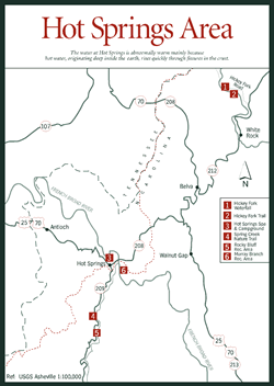
Springs [Fig. 21(3), Fig. 20] Located on the French Broad River, the friendly town of Hot Springs has a history revolving around water, especially the geothermal waters that give the town its name. Geothermal hot springs have been used by humans for centuries. The Romans, for example, used hot springs and mineral baths for medicinal, bathing, and recreational purposes. The waters at Hot Springs are abnormally warm primarily because the hot water deep within the earth finds an easy conduit here, probably in the form of fractures within the earth, that allows it to rise to the surface more quickly. When the hot water escapes at ground surface, it forms a hot spring.
During the late 1800s, Hot Springs became famous as a health resort town. Doctors, patients, and vacationers from all over the world flocked to the town, believing the curative powers of the hot mineral waters would heal all of their ills. Over the years, many testimonials have been filed by visitors who claim that the mineral waters of Hot Springs brought them relief from stomach, liver, and gall-bladder ailments, rheumatism, and arthritis.
People still enjoy these geothermal springs today at Hot Springs Spa and Campground [Fig. 20(3)]. The water, which maintains a natural temperature of 100 degrees Fahrenheit year-round, bubbles up into modern Jacuzzi tubs in secluded outdoor settings along the French Broad River and Spring Creek. In addition to leisurely soaks in the tubs, the spa also offers massage therapy and riverside camping.
Nestled among the loftiest peaks of the southern Appalachians, Hot Springs is a favorite with hikers on the Appalachian Trail (AT), which runs through town, providing hikers easy access to stores and supplies. Lovers Leap Rock, one of the most popular AT side hikes in the area, offers a grand view of the French Broad River 500 feet below. Lovers Leap Rock gets its name from a Cherokee Indian legend that tells of a maiden who threw herself from the steep cliff after learning her lover had been killed by a jealous beau. While this hike is only 2.6 miles round-trip, it is a strenuous hike, gaining 1,000 feet in elevation. From town, take Main Street north following the white blazes painted on the sidewalk. After the trail crosses the French Broad River Bridge, it curves under the bridge on Lovers Leap Road for .3 mile to Silver Mine Creek parking area. Continue through the U.S. Forest Service gate and follow the orange blazes which mark the trail to Lovers Leap Rock.
Rocky Bluff Recreation Area [Fig. 20(5)] offers camping, picnicking, hiking, nature study, and fishing in Spring Creek, as well as flush toilets, lavatories, and water fountains. The site was formerly residential farmland and, at one time, a school. The recreation area is open from mid-April to mid-November, and can be reached by driving south from Hot Springs on NC 209 for 3.3 miles.
The 1.6-mile Spring Creek Nature Trail [Fig. 20(4)] is located at Rocky Bluff Recreation Area and is an easy-to-moderate, yellow-blazed trail. At .5 mile, there is a nice vista of Spring Creek. Then the trail continues around the mountain, following along the side of the cascading stream. Keep a lookout for Eastern hemlock (Tsuga canadensis), basswood (Tilia americana), oaks, and an abundance of wildflowers including varieties of trillium.
Only 1.1 miles in length, the trail to Hickey Fork Waterfall [Fig. 20(1)] is strenuous. The falls are rich with growing mosses. The small grottos that can be spotted behind its mist provide a habitat for the spray-cliff natural community. From Hot Springs, head north on NC 208 until it intersects with NC 212, and take a right. Continue for 6.8 miles to NC 1310, which is known as Hickey Fork Road. Turn left and drive until you see the parking area on the right. The trailhead begins about 200 feet up the road, on the left. Hike in about 1 mile. At this point, a smaller yet beautiful cascade occurs on the right. To reach the main waterfall, continue another .1 mile. Some bushwhacking is necessary to reach the base of the waterfall. Hemlock, white pine (Pinus strobus), yellow-poplar (Liriodendron tulipifera), rhododendron (Rhododendron catawbiense and maximum), mountain laurel (Kalmia latifolia), dog-hobble (Viburnum alnifolium), and ferns are all common.
The Murray Branch Recreation Area [Fig. 20(6)] is located 6 miles down the French Broad River from Hot Springs. The area offers recreational opportunities for picnicking, fishing, and canoe access to the river. Facilities at Murray Branch, under the shade of pines, include picnic tables, grills, restrooms, water, and two picnic shelters for large groups. An easy, 1-mile loop trail is adjacent to the area, providing a bird's-eye view of the French Broad River and the surrounding valley.
The location of the town along the French Broad River also provides easy access for whitewater rafting, canoeing, and kayaking. A variety of outfitters have been established in the area to provide guided trips and rentals (see Appendix C).
Rocky Bluff Campground, part of the Rocky Bluff Recreation Area, is located on State Highway 209. This campground offers 30 campsites on a first come, first served basis. Two of the campsites can accommodate trailers up to 18 feet long. There is a charge for camping. Open May–Oct.
[Fig. 21(25)] According to local legend, Harmon Den was named for a man, Harmon, who lived by himself under a large rock outcropping on what is now Harmon Den Mountain. Like other areas of the region, Harmon Den was heavily logged earlier this century. Timber companies cut all the forest in the Cold Springs Creek drainage and built logging roads, narrow-gauge railroads, and amenities for the logging crews and their families. Relief from this destruction came in 1936 when the USDA Forest Service purchased Harmon Den and operated a Civilian Conservation Corps camp in the area during the 1940s; corpsmen planted many of the white pines still evident today.
Although I-40 runs through much of Harmon Den Area, the lack of paved roads and developed communities keeps this remote area pristine and uncrowded. Twenty-one miles of the Appalachian Trail and 17 miles of trails such as the Buckeye Ridge Trail afford spectacular views of the surrounding Great Smoky, Snowbird, and Black mountains. The trail network features five horse trails and two additional hiking trails that serve mountain bikers as well. Following the old roadbeds through hardwood-hemlock forests and along streambeds, these trails open opportunities to experience the abundance of wildlife flourishing in this quiet area. The renowned Max Patch Trail (see Max Patch) is also part of the Harmon Den Area.
 Max
Patch
Max
Patch [Fig. 21(4)] Whether black clouds ominously color the surrounding mountains or a clear blue sky affords breathtakingly panoramic views of the Black, Bald, Balsam, and Great Smoky mountains, Max Patch is a favorite trail with hikers of all degrees of endurance. It is a gentle climb across the southernmost bald on the Appalachian Trail to its grassy summit at 4,629 feet. During the warmer seasons, the trail abounds with wildflowers. This relatively short hike can be extended by continuing either north or south on the Appalachian Trail.
The northern segment travels 20 miles to the town of Hot Springs. The first 7 miles along this segment are easy, gaining less than 1,000 feet in elevation, but the path soon climbs steadily toward the wooded summit of Walnut Mountain (elevation 4,280 feet). After a short stretch on an old roadbed, the trail reaches Catpen Gap and ascends Bluff Mountain (elevation 4,686 feet). From here the trail drops steadily, losing more than 3,000 feet along its 10-mile descent into Hot Springs. After a two-day hike, the Hot Springs Spa offers a luxurious change of pace (see Hot Springs).
Privately owned until 1982, the land covered by the trail had been used for grazing sheep and cattle. An offer to sell to a ski development was fortunately countered by the U.S. Forest Service, which bought the 392 acres for the Appalachian Trail.
[Fig. 21(13)] The trail to Rattlesnake Lodge begins its gentle ascent up the Bull Gap range a short distance off the Blue Ridge Parkway on Ox Creek Road. Numerous switchbacks along a former carriage trail are as handy for today's walker as they were at the turn of the century for the family of Dr. Chase P. Ambler. A prominent pulmonary physician and noted conservationist, Ambler created a rough-hewn mountain estate for his family from the virgin land thick with oak, hickory, birch, black walnut (Juglans nigra), and American chestnut (Castanea dentata). The estate eventually included a two-story lodge, workshop, springhouse, log barn, corncrib, tenant's house, swimming pool, and tennis court, but it burned to the ground in 1925. All that stands today are the still-impressive stone foundations of the house, the walls of the springhouse, and a few apple trees from the orchards. The trail, which is part of the Mountains-to-Sea Trail system, features almost continuous mountain vistas and acres of pencil-straight hardwoods sheltering the trail. An impressive array of wildflowers, especially jewelweed (Impatiens pallida and I. capensis) and houstonia (Houstonia purpurea), hug the pathway, and each spring daffodils overtake the hollow where the estate stood. The National Park Service purchased 233 acres from Dr. Ambler's estate in the mid-1970s.
Dr. Ambler is recognized for his contributions to forestry conservation and wilderness preservation in the region. A 6,100-foot peak in the Great Smoky Mountains National Park is named in honor of his tireless efforts to establish the park, and the sign at the entrance to Curtis Creek Area (see Curtis Creek, page 93) recognizes his dedication to the preservation of national forest lands.
The Bull Gap area offers excellent opportunities for watching the spring songbird migration and is considered one of the best places in North Carolina's mountains for spotting cerulean warblers (Dendroica cerulea). The area harbors other late-spring and summer birds such as the pileated woodpecker (Dryocopus pileatus), downy woodpecker (Dendrocopos pubsecens), Carolina wren (Thryothorus ludovicianus), wood thrush (Hylocichla mustelina), indigo bunting (Passerina cyanea), and a variety of warblers.