 New
River State Park New
River State Park
New
River State Park New
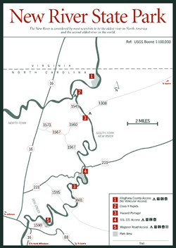
River State Park [Fig. 7, Fig. 3(7)] Although it is not apparent from its name, the New River is considered by most scientists to be the oldest river in North America and the second oldest river in the world. Even before the Appalachian Mountains were formed, the New River ran almost the same path across the Blue Ridge Plateau it runs today. Since 1976, 26.5 miles of the New River have been protected as a National Wild and Scenic River System, which prohibits the construction of dams and reservoirs. This section of the New River (22 miles of the South Fork downstream to its confluence with the North Fork, and 4.5 miles of the main stem of the New River north to the North Carolina and Virginia line) and three designated parkland areas along its course make up the 1,460-acre New River State Park.
The New River's meandering course through the park has exposed rocks belonging to two major geologic units—biotite granitic gneiss of the Elk Park Plutonic Group, and gneiss and schist of the 800-million-year-old Ashe Metamorphic Suite. More than 1 billion years old, the Elk Park Plutonic Group formations represent some of the oldest rocks in the Appalachians.
While the New River's calm waters offer easy canoeing perfect for beginners, families, and groups, experienced paddlers also enjoy the unparalleled scenery and tranquillity. Along the way, river travelers experience such geological features as rapids, potholes, and floodplains. Paddlers along the South Fork of the New River can observe downfoldings of rocks, called the Ararat River Synclinorium, that formed a trough during the formation of the Appalachian Mountains. Also of note is a granite wall at the Alleghany County access area called The Bluffs. Rising 200 feet above river level, the ancient granitic wall is more than 1 billion years old.
Archeological investigations indicate the presence of humans in the New River area as early as 10,000 years ago. Precolonial Canawhay, Shawnee, Creek, and Cherokee Indians used the New River and the surrounding areas for migration, trade, and hunting. Later, European settlers used the land for farming, mining, and timber.
Despite its status as one of the most undeveloped Appalachian rivers, the New River area has suffered from major clearing and cutting. Most of the virgin forest is gone, and the woodlands are now composed of second- and third-growth trees. Where the soil is dry and shallow, oaks and hickories grow in abundance with maples, elms, Eastern redcedars (Juniperus virginiana), and pines. Along the banks of the New River's feeder streams, moist soil provides an ideal environment for American beech (Fagus grandifolia), blackgum (Nyssa sylvatica), yellow-poplar, black locust, and yellow birch trees. Beneath the forest canopy, dogwood, sourwood (Oxydendrum arboreum), sassafras, alder, huckleberry (Gaylussacia baccata), and hydrangea (Hydrangea arborescens) flourish. At least 14 species of rare, threatened, or endangered plants grow in the New River valley, including rattlesnake root, Carolina saxifrage, Carey's saxifrage, spreading avens, and purple sedge.
 Beavers
(Castor canadensis) have recently been reintroduced to the New River
area, and sightings of white-tailed deer, black bears, mink (Mustela vison),
muskrats (Ondatra zibethicus), otters (Lutra canadensis), and
raccoons are likely. A variety of lizards, turtles, salamanders, and nonpoisonous
water snakes are common to the wetlands and river's edge, while smallmouth bass
(Micropterus dolomieui) and rainbow trout (Salmo gairdneri) populate
the river and its tributaries. In fact, locals claim that the New River offers
some of the best bass fishing in the state. Most fishing is done by wading the
shallow waters, as banks are either limited or privately owned.
Beavers
(Castor canadensis) have recently been reintroduced to the New River
area, and sightings of white-tailed deer, black bears, mink (Mustela vison),
muskrats (Ondatra zibethicus), otters (Lutra canadensis), and
raccoons are likely. A variety of lizards, turtles, salamanders, and nonpoisonous
water snakes are common to the wetlands and river's edge, while smallmouth bass
(Micropterus dolomieui) and rainbow trout (Salmo gairdneri) populate
the river and its tributaries. In fact, locals claim that the New River offers
some of the best bass fishing in the state. Most fishing is done by wading the
shallow waters, as banks are either limited or privately owned.
For hikers, an easy, 1-mile, self-guiding nature trail at the Wagoner Road Access area [Fig. 7(5)] features 19 interpretive stations offering information about creek habitat, lichens, flowers, and trees. A new 1.5-mile hiking trail connects with the nature trail and courses through surrounding woodlands with a segment paralleling the river. Both trails are accessible from the Wagoner Road Access parking lot, picnic area, and campground.