 Lake
James State Park Lake
James State Park
Lake
James State Park Lake
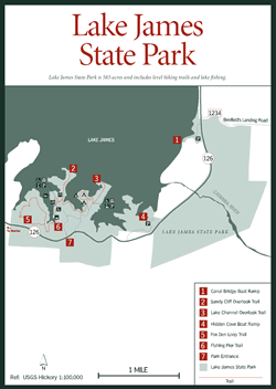
James State Park [Fig. 16] With long stretches of blue water surrounded by lush green foliage and a backdrop of dramatic mountain terrain, there are advantages to the lowlands, especially at Lake James State Park, where 585 acres include level hiking trails and lake fishing in the shadow of breathtaking mountain peaks.
Opened in June 1989, Lake James State Park lies on the south shore of a 6,510-acre impoundment on the Catawba River and its two tributaries, Paddy Creek and the Linville River. Formed between 1916 and 1923 as one of nine man-made lakes by Duke Power Company, Lake James is named for James B. Duke, founder of Duke Power Company.
The lake's 150 miles of wooded shoreline extends into coves and peninsulas that provide easy access to an assortment of water sports and fishing. The lakeshore behind the multipurpose park building, which houses the park office, concession stand, restrooms, and rinse-off showers, has been developed as a protected beach for swimming. In addition, skiing and all types of boating are permitted. Two boat ramps, Hidden Cove [Fig. 16(4)] and Canal Bridge [Fig. 16(1)], are within the park, and numerous privately operated launch sites and marinas circle the lake, some offering boats and motors for rent. Because of Lake James's numerous coves, canoeing here can be peaceful and private.
Submerged islands, rocky points, and plentiful coves make Lake James the site of annual fishing tournaments and friendly competitions. Record-breaking catches have been reported and verified as more than just another fishing story. Fish populations include three types of bass: largemouth (Micropterus salmoides), smallmouth (Micropterus dolomieui), and white (Morone chrysops). Walleye (Stizostedion vitreum) and bluegill (Lepomis macrochirus) are also popular catches at Lake James. While most choose boat fishing, casting sites include a small pier near the park office and one along the shore. During a quiet morning of fishing, a pair of Canada geese and flocks of wood ducks and other waterfowl can be seen only a few feet from the Lake Channel Overlook.
 While
some may call the hiking trails within the park easy, none would contest their
spectacular views. Two gentle footpaths, the Lake Channel Overlook Trail [Fig.
16(3)] and Sandy Cliff Trail [Fig.
16(2)], wander in and out of the shoreline
on their way toward wooded overlooks with benches. Along the way they provide
spectacular vistas of the mountains in general and of the granite-faced Table
Rock in particular, as well as the upper elevations of Linville Gorge. It can
be windy along the lakeshore, something to keep in mind when planning a winter
hiking trip. That wind, coupled with the water erosion, is responsible for the
loss of as much as 1 foot of land per year on the lake's north side.
While
some may call the hiking trails within the park easy, none would contest their
spectacular views. Two gentle footpaths, the Lake Channel Overlook Trail [Fig.
16(3)] and Sandy Cliff Trail [Fig.
16(2)], wander in and out of the shoreline
on their way toward wooded overlooks with benches. Along the way they provide
spectacular vistas of the mountains in general and of the granite-faced Table
Rock in particular, as well as the upper elevations of Linville Gorge. It can
be windy along the lakeshore, something to keep in mind when planning a winter
hiking trip. That wind, coupled with the water erosion, is responsible for the
loss of as much as 1 foot of land per year on the lake's north side.
Both trails wind through the park's young pine-hardwood forests that support huge specimens of oak, hickory, poplar, pine, and some cedar. Dogwood trees are particularly evident during late April and early May when their white bracts are in full bloom. In this rugged section of the country these trails afford a pleasant opportunity to hikers who cannot walk great distances.
Wildflowers thrive in the moist, wooded conditions of the park. A full array of specimens bloom from early spring through fall, among them pink lady slipper (Cypripendium acaule), jack-in-the-pulpit, bloodroot, and a variety of violets. Blackberries (Rubus argutus) and dewberries (Rubus fagellaris) are also here for the picking in July.
Park rangers present nature programs twice a month including guided hikes, tree identification sessions, canoe trips, and wildflower walks.