 Shining
Rock Wilderness Area Shining
Rock Wilderness Area
Shining
Rock Wilderness Area Shining
Rock Wilderness Area [Fig. 22(27), Fig. 27] Few words fire man's imagination more than the term "wilderness." Once defined as wild areas unexplored by humans, wilderness today generally refers to areas that have been left relatively undisturbed or those which have recovered from man's activities.
For the average person, though, wilderness has several meanings: It is a place to escape the pressures of civilization, to study a wondrous variety of plants and animals, to experience nature by "taking only photographs and leaving only footprints," or to physically challenge oneself with survival on nature's own occasionally harsh terms.
Acknowledging these contemporary views of wilderness, Congress in 1964 passed the Wilderness Act which elevated the concept of wilderness to a level of special significance. The act provided for the protection of areas according to Congress's own legal definition of wilderness. According the Wilderness Act of 1964, a wilderness area is defined as undeveloped federal land, at least 5,000 acres in size, which retains its primeval character and influence without permanent improvements or human habitation. With this act, the groundwork was laid for the establishment of one of the nation's first wilderness areas, Shining Rock Wilderness. This area was later joined by the adjacent Middle Prong Wilderness Area. The 18,500-acre Shining Rock and the 7,900-acre Middle Prong wilderness areas make up the northwestern corner of Pisgah National Forest.
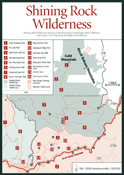
The rugged terrain of the Shining Rock Wilderness includes five mountain peaks rising higher than 6,000 feet, with Cold Mountain at 6,030 feet as the highest. The 10-mile range known as Shining Rock Ledge offers spectacular vistas and diverse habitats, including what was once one of the most impressive stands of spruce-fir forest in the South. Around 1900, spruce trees towered above the forest floor, some as high as 100 feet with 4-foot diameters. But that all changed a little later in the century due to unrestricted logging.
In 1906, the Champion Fibre Company began buying huge tracts of land for a paper pulp and tannin processing operation at Canton. They established a company town named Sunburst as a base of operations at the junction of the Right Hand Prong and Middle Prong of the Pigeon River's West Fork.
The quality and quantity of pulpwood proved inadequate, and in 1911 the land was sold to Champion Lumber Company. The Sunburst community moved downstream to what is now Lake Logan, where a band sawmill was set up to process timber for the construction market. The original mill location is currently the site of the Sunburst Campground and Picnic Area.
The logging era of the area not only depleted the spruce but also many of the hardwoods, hemlocks, and Fraser firs. The forest ecology was further disrupted when, in 1925, a major forest fire covered the region. Eventually the area became associated with other southern Appalachian tracts collectively referred to as "the land that nobody wanted." Finally, in 1935, at the height of the Great Depression, the area was purchased by the federal government for inclusion in the Pisgah National Forest. But a final insult to the land came in 1942 when the worst series of fires in recent history swept Western North Carolina, permanently altering the Shining Rock and Middle Prong vegetation.
The forest fires at Shining Rock destroyed the former lush forest, creating open patches of shrub communities that have persisted for many decades. Many of its slopes support masses of blueberry bushes which attract black bears and hungry hikers alike. For many years, the low vegetation allowed white quartz outcrops to reflect colorful light from sunsets, but maturing trees have now hidden most of this "shining rock." Of the eight hiking trails traveling more than 35 miles through the wilderness, several trails lead to these outcrops on Shining Rock Ledge, the centerpiece of the area, and vistas that make long hikes worthwhile. Part of the Art Loeb Trail [Fig. 27(2)] also traverses Shining Rock Wilderness, and all trails within the wilderness either connect with or have access to the Art Loeb Trail. For those seeking solitude, the Little East Fork [Fig. 27(3)], Fork Mountain [Fig. 27(5)], Old Butt Knob [Fig. 27(4)], and Cold Mountain [Fig. 27(1)] trails are reported to be the least used within the wilderness.
The easier the access, the more popular the trails. Such is the case with the four trails leading off the Black Balsam parking area: Art Loeb [Fig. 27(2)], Ivestor Gap, Flat Laurel Creek, and Sam's Knob [Fig. 27(12)] trails. The Black Balsam parking area is located where FR 816 ends, approximately 1.2 miles from the Blue Ridge Parkway milepost 420.2.
Highlights of the trails within the wilderness include cascades and pools of the Pigeon River along the Little East Fork Trail [Fig. 27(3)]; a profusion of rhododendron and laurel along Fork Mountain Trail; and wildflowers and mighty basswood and locust trees on Fire Scald Ridge Trail. Big East Fork Trail offers numerous camping areas near the rapids and clear pools of the East Fork of the Pigeon River, where excellent fishing is reported. Shining Creek Trail [Fig. 27(6)] courses along the banks of Shining Creek where wildflowers thrive under the canopy of hickory, birch, rhododendron, and spruce. Equestrian use is limited to two trails: Ivestor Gap (to the wilderness boundary) and Little East Fort trails.
The establishment of a wilderness in the region is an excellent example of man's ability to correct past mistakes. Half a century of natural growth and forest management have helped to heal the southern Appalachian forests. In addition, the 1984 North Carolina Wilderness Act increased Shining Rock acreage from 13,600 to 18,500 acres and created the Middle Prong Wilderness, reflecting the increasing importance that the American public places on its special wilderness areas.