Our north Georgia mountains are masses of ancient rock on which life has but a tenuous foothold. A short history of the area's geology helps us appreciate nature's management of such finite entities as water, air, and soil in such remarkably beautiful surroundings. Moreover, greater knowledge of the function of ecological systems like the southern Appalachian bioregion is essential for the survival of man as a part of—not apart from—the natural world. This understanding, transcending economic and political considerations, now becomes the major bridge uniting peoples of the earth. Compared with the youthful Rockies or Himalayas, Georgia's mountains are hoary with age. Some of the basement rocks, or roots, of the early Blue Ridge formed over a billion years ago. The bulk of our mountains, however, was derived from ancient marine sediments between 200 and 450 million years ago. These sediments, such as sands and silts, were transformed or metamorphosed into the hard rock that forms the backbone of the Blue Ridge. This was accomplished by uplift, heat, and pressure resulting from enormous forces generated by the collision of North America with other drifting continents.
Look at any rock face exposed in highway cuts such as at Hog Pen Gap on the Richard Russell Scenic Highway or at Woodall Shoals on the Chattooga River. Here it can be seen how heat and pressure deep within the earth caused near-molten rock to flow and fold into visible contortions. In the western part of the Blue Ridge, the rocks were less metamorphosed by these processes.
Least changed of all were the thick beds of sediments in northwest Georgia. Here, sands hardened into sandstone, and mud or silt into shale, while the shells of minute marine life became limestone. These rocks show little of the folding and distortion that you see east of the great fault line between Chatsworth and Cartersville which divides the Valley and Ridge from the Western Blue Ridge.
Regardless of bedrock type, however, most forest communities form soils that are remarkably similar. Normally, about 22 minerals occur in most rock types; two or three others are supplied by atmospheric fallout. These minerals are carefully concentrated and recycled by the forest. Occasionally, where carbonate rocks, such as limestone, outcrop near the surface, unique plants grow and require lots of calcium, as at Pigeon Mountain or Panther Creek. Sometimes, when rocks are low in some essential minerals, as at Buck Creek, a peculiar pine barren community develops.
Stripped of their forest cover, our Blue Ridge Mountains would resemble Stone Mountain. The thin skin of soil that hides their nakedness is made possible only by plant life, aided by abundant rainfall. Unless one has seen the bare rock where the entire side of a mountain has slid off, or gazed into Toxaway Gorge, it is hard to understand how important the vegetation cover is and how powerful the force of water is.
While collisions with other continents slowly raised the Appalachians, rains kept eroding them almost as fast as they were uplifted. Incredibly, geologists claim that a thickness of from 5 to 10 miles of Appalachian mountain rock has disintegrated and washed downhill in the last 300 million years. These sediments formed south Georgia, the coastal landforms and much of the continental shelf. Rains from the sun-powered water cycle are still trying to wash our mountains away, but nature has developed a remarkably tough and protective forest cover that slows down this process.
Ironically, the mountain forest cannot exist without this 5 to 8 feet of water that pours down in a single year. The mountain forests are expert in conserving and managing this precious substance through many millennia of trial and error. The forest operates as a soil-building and water-holding device, powered by solar energy. The excess water not used by the system runs off as streams and rivers which we can, with wisdom, use ourselves. While there are mountain "products" other than water, we must never lose sight of the primary value of the mountains—the cost-free (to us) management of rock, soil, water, air, life, and sun energy. Anything that man does there must be prefaced with the question, "Are we compromising or damaging these vital life-support functions?"
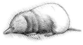
Our mountains have been forested for at least 2 million years. Unglaciated during this time, they have stood as temperate-zone refuges for a diverse assemblage of terrestrial plants and animals, perhaps unequalled outside of the tropical rainforest. Biologically speaking, a trip up a 6,000-foot mountain is equivalent to driving 1,000 miles north. Because of this, many species of plants and animals can live in our mountains, especially in north-facing coves where it is always moist and cool. Once, boreal spruce-fir forests, such as now clothe much of Canada, covered our Georgia mountains, with alpine tundra on the highest peaks. When the climate warmed, these cold-adapted environments disappeared. Along the highest elevations of the Georgia Blue Ridge, they left behind some ice-age animal life—relicts such as the red-back vole and perhaps the red squirrel.
From the top of our highest peaks, as far as the eye can see, mountain slopes appear to be clothed in a uniform sea of green. Actually, this vista is not at all uniform, for what one sees is a remarkable mosaic of various combinations of rock, soil, plants, and animals organized into specific environments. Some of these combinations are considered by ecologists as communities, associations, or forest types. Each is adapted to certain slopes, temperatures, soil depths, compass exposures, and rainfall.
Described below are the major natural environments that occur in the Georgia mountains and are often encountered in the text.
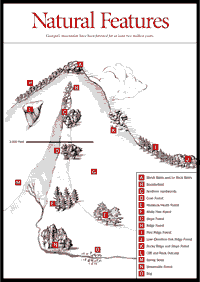 Shrub
Balds and/or Rock Balds. [Fig.
2(A)] Examples are Brasstown Bald [Fig.
30(6)], parts of Standing Indian [Fig.
34(15)], Pickens Nose [Fig.
39(11)], Tray Mountain [Fig.
29], and Blood Mountain [Fig.
24]. At the highest elevations, which were once alpine tundra, we now find
Catawba rhododendron, mountain ash, and dwarf willow as plants characteristic
of the shrub bald. Some mountains are called "balds" but have forested
tops. Hightower Bald and Dick's Knob have, for example, dwarfed oak forests
covering their summits. There may be a thick understory of beaked hazelnut or
another shrub.
Shrub
Balds and/or Rock Balds. [Fig.
2(A)] Examples are Brasstown Bald [Fig.
30(6)], parts of Standing Indian [Fig.
34(15)], Pickens Nose [Fig.
39(11)], Tray Mountain [Fig.
29], and Blood Mountain [Fig.
24]. At the highest elevations, which were once alpine tundra, we now find
Catawba rhododendron, mountain ash, and dwarf willow as plants characteristic
of the shrub bald. Some mountains are called "balds" but have forested
tops. Hightower Bald and Dick's Knob have, for example, dwarfed oak forests
covering their summits. There may be a thick understory of beaked hazelnut or
another shrub.
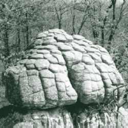
Boulderfields. [Fig. 2(B)] Lying just down slope from the summit of most of our peaks are boulderfields, which fill the top part of north- and northwest-facing coves, particularly if there is seeping or running water. The jumbled mass of boulders has resulted from ice-wedging during the Pleistocene period, perhaps 20,000 years ago. Boulderfields seldom extend below 3,200 feet. Although the moss-covered boulders are difficult to walk across, they are a photographer's delight and are most photogenic after leaf fall. In spite of the rocky nature of this environment, spring wildflowers are abundant. Trees such as yellow birch and basswood may occur. Perhaps the "best" boulderfield is on the north face of Tray Mountain [Fig. 29] between the summit and Corbin Creek Road. The one most accessible by car lies just above the parking area at Sosebee Cove [Fig. 24(5)] where, with diligent search, a few rare yellowwood trees may be found.
Northern Hardwoods. [Fig. 2(C)] This forest type usually lies between the boulderfields and the cove hardwoods (below), generally above 3,000 feet. Buckeye, basswood, and yellow birch are diagnostic. Sometimes beech and sugar maple may be present. This environment has exceptional wildflower displays. The dense, often knee-deep herb layer helps create a deep, black, loamy soil. Expect to find the mountain garlic or ramp (Allium tricoccum), spring beauty, ginseng, squirrel corn, Dutchman's breeches, waterleaf, and umbrella leaf. The giant hellebore (Veratrum viride) may be present. Three wood ferns are characteristic: Goldie's, marginal, and intermediate. The higher the elevation, the rarer the herbaceous plants.
To see the upper limit of the hardwood forest and a boulderfield, hike the old Wagon Train Trail [Fig. 30(1)] at Brasstown Bald. Around on the north face just below the tower are giant yellow birch festooned with "old man's beard" lichen and dripping with moisture from cloud condensation. This environment is Georgia's only cloud forest. This relict community is extremely vulnerable to fire or logging.
Cove Forests. [Fig. 2(D)] Below the northern hardwoods is the more extensive cove hardwood forest. There is a greater diversity of trees here, including various oaks, tulip poplar, ash, silverbell, and magnolia. Before the chestnut blight of the 1930s, many cove forests were full of chestnut trees. Since tulip poplars are present in most cove forests and have wind-borne seeds, they were able to seed in on the death of the chestnut.
Poplar also follows overintensive logging, as below the parking area in Sosebee's Cove. The whitish stumps of dead chestnut can still be seen in many coves. Old mountain pastures often reverted to almost pure stands of poplar. Near-original old growth cove forest can be seen in the northeast sector of the Cooper Creek Scenic Area [Fig. 22]. There, the dead chestnut logs were removed and sawed up on the spot. Some of the old poplars, some 18 feet in circumference, still remain, standing among huge white and red oaks. While shrubs are limited in cove forests, a variety of herbs is present, depending on soil depth and moisture.
Hemlock/Heath Forests. [Fig. 2(E)] Below the cove hardwood forest and often extending up the streams through it, grows the moisture-loving Canadian hemlock, with its delicate, evergreen foliage. It generally always has an understory of the common, evergreen rosebay rhododendron, which is a member of the heath family. Rhododendron may create nearly impenetrable thickets. This is one of the challenges facing trout fishermen where there are no trails. Few herbs are present. This environment may be seen along the lower reaches of Mulky Creek [Fig. 22(l)] near the Cooper Creek Scenic Area. A few large hemlocks remain on Soapstone Creek along the drive to Jack's Gap [Fig. 30(9)].
White Pine Forests. [Fig. 2(F)] There is some question as to the existence of stands of white pine prior to human clearing, logging, and fire prevention (white pine is very sensitive to fire). Some very beautiful open stands of white pine occur along the Chattooga River, especially above Burrell's Ford Bridge [Fig. 48(11)] and along the Reed Creek bottoms [Fig. 43(22), Fig. 44(26)] north of the Russell Bridge. Much white pine can also be seen from the Richard Russell Scenic Highway and near the Cooper Creek Scenic Area. It is believed that originally the white pine grew as scattered trees in fire-protected areas in places like the extensive bluffs along the Chattooga River. White pines are less prone to beetle attack than are the successional stands of Virginia pine which follow environmental disturbance at low elevations throughout much of the Blue Ridge.
Slope Forests. [Fig. 2(G)] These are mostly oak-hickory-chestnut forests and cover the most terrain of any environment. The chestnut—unfortunately for the wildlife which fattened for the winter on its nuts—is gone, except as sprouts and small trees at high elevations. Slope forests vary tremendously in species composition that, in turn, depends on soil depth, percent slope, compass exposure, and so on. Given sufficient soil moisture, white oak will dominate. Sourwood and black gum thrive on drier sites. Hickories are adaptable and widespread. While the herbaceous plants are not as rare and interesting as those in mountain coves, they are numerous. As distinguished from the cove forests, the slope forests have an abundance of shrubs. Blueberries are widespread under more open canopies here, as well as on ridges. Sweetshrub and buffalo nut (a favorite deer food) are common, as are azaleas. On drier sites horsesugar is outstanding.
Ridge Forests. [Fig. 2(H)] Among the types of ridge forests, the high elevation oak ridge forest is outstanding. This forest covers the higher ridges of the Blue Ridge, such as those traversed by the Appalachian Trail. This forest, mostly virgin red oak, has trees that are dwarfed and limby. A 12-inch-diameter tree may be 100 years old. These old growth ridge forests were rarely logged, since the trunks were too short. Sometimes, as in the Cohuttas, white oaks may dominate. High-altitude ridge forests have a variety of attractive understory plants. From Standing Indian [Fig 34(15)], one descends through tunnels of Catawba or purple rhododendron. Elsewhere, flame azalea dominates, or ferns (New York, hayscented), beautiful little wiry sedges, or grasses may carpet the ridgeline. In summer, dense herb growth may encroach, particularly white snakeroot (Eupatorium rugosum), one of the plants suspected of causing the "milk sick" that killed numerous settlers who grazed cattle in the mountains.
A variety of blueberries occupies mountain ridges, which are more open than cove forests. The highbush blueberry (Vaccinium constablei) is associated with high-elevation red oak forests. On rocky, white oak ridge forests, both deerberry (V. stamineum) and buckberry (Gaylussacia ursina) occur, while on lower, drier ridges the low blueberry (V. vacillans) forms thick ground cover. Grouse and bear feast on blueberries in summer and fall.
Another type of ridge forest is a pine ridge forest. At higher elevations, the pines are chiefly table mountain pine, which seems to prefer rocks and cliff edges. It is common on ridges off the south face of Rabun Bald [Fig. 41(10)] and along the edge of the Cedar Cliffs along Big Creek [Fig. 44(3)] and occurs along the rim of Tallulah Gorge. At lower elevations, pitch pine is dominant, as on the scenic road across Patterson Gap [Fig. 38(25)], where the rare sweetfern grows in the herb layer. The soils of these pine communities appear drier and more acid. Various acid-loving heaths occur in the understory. There is a low-elevation hardwood ridge forest, a "dry" forest, which is widespread. Three oaks tend to predominate: scarlet, post, and southern red.
Rocky Ridges and Slope Forests. [Fig. 2(K)] Chestnut oaks tend to dominate on rocky ridges in the Blue Ridge and on slopes where the soil is thin and rocky. The upper, west-facing slopes of Lookout Mountain are often largely chestnut oak. On the western flank of Pigeon Mountain near The Pocket, in what can be called a limestone terrace environment, is a curious forest of chinquapin oak, red cedar, and the rather rare smoketree.
 Cliffs
and Rock Outcrops. [Fig.
2(L)] Our Blue Ridge is really solid rock with only a thin veneer of soil
held by plant roots. When it is too steep for plants to stabilize, a naked cliff
emerges. If the rock is perennially wet, very rare northern or tropical ferns
and mosses may occur (Cullasaja Gorge [Fig.
49(2)], Escarpment Gorges [Fig.
51(1,2,3)]). Around drier cliffs (Tallulah Gorge [Fig.
38(2)], Satulah Mountain [Fig.
49], Cedar Cliffs [Fig.
44(4)]), you may see two rare conifers, Carolina hemlock and table mountain
pine. Around and above cliffs on the north side of high ridges, rosebay rhododendron
prevails; on the drier south side, mountain laurel. The highest rocky tops almost
always bear the gorgeous purple rhododendron. In some moist, rocky areas at
lower elevations (Tallulah Falls), Carolina rhododendron predominates. Big dense
patches of evergreen heaths are known by the mountaineers as "slicks"
or "hells." Mountaineers also call rhododendron "laurel"
and mountain laurel "ivy." One of the most remarkable environments
on an outcrop is called a cedar glade. In Georgia, it is found in the Chickamauga
and Chattanooga National Military Park. It occurs on shallow-soiled, limestone
slopes and low ridges. It is a shrub-free area thick with red cedars, along
with old, dwarfed chinquapin oaks and with rare grasses and herbs allied to
those of midwestern prairies. This is the only Georgia outlier of vast glades
that cover central Tennessee. Red cedars are also common along the rocky bluffs
in the Valley and Ridge and sometimes occur on rock outcrops in the Blue Ridge,
as on top of Chimney Mountain [Fig.
29(58)].
Cliffs
and Rock Outcrops. [Fig.
2(L)] Our Blue Ridge is really solid rock with only a thin veneer of soil
held by plant roots. When it is too steep for plants to stabilize, a naked cliff
emerges. If the rock is perennially wet, very rare northern or tropical ferns
and mosses may occur (Cullasaja Gorge [Fig.
49(2)], Escarpment Gorges [Fig.
51(1,2,3)]). Around drier cliffs (Tallulah Gorge [Fig.
38(2)], Satulah Mountain [Fig.
49], Cedar Cliffs [Fig.
44(4)]), you may see two rare conifers, Carolina hemlock and table mountain
pine. Around and above cliffs on the north side of high ridges, rosebay rhododendron
prevails; on the drier south side, mountain laurel. The highest rocky tops almost
always bear the gorgeous purple rhododendron. In some moist, rocky areas at
lower elevations (Tallulah Falls), Carolina rhododendron predominates. Big dense
patches of evergreen heaths are known by the mountaineers as "slicks"
or "hells." Mountaineers also call rhododendron "laurel"
and mountain laurel "ivy." One of the most remarkable environments
on an outcrop is called a cedar glade. In Georgia, it is found in the Chickamauga
and Chattanooga National Military Park. It occurs on shallow-soiled, limestone
slopes and low ridges. It is a shrub-free area thick with red cedars, along
with old, dwarfed chinquapin oaks and with rare grasses and herbs allied to
those of midwestern prairies. This is the only Georgia outlier of vast glades
that cover central Tennessee. Red cedars are also common along the rocky bluffs
in the Valley and Ridge and sometimes occur on rock outcrops in the Blue Ridge,
as on top of Chimney Mountain [Fig.
29(58)].
Streamside Forests. [Fig. 2(N)] Along most of our rivers and larger streams, a streamside forest grows. This is distinguished by colorful and often rare trees and shrubs. Hemlocks and rosebay rhododendron are generally present. The rocky, more open bluffs support small trees such as the rare mountain camellia (Stewartia), serviceberry, and witch hazel. If moist enough, the environment supports mountain pepperbush, viburnums, and alders, either as shrubs or as small trees. Dense evergreen thickets of dog hobble, also known as leucothoe, are common. Characteristic herbs, such as yellowroot, may be present.
Bogs and Spring Seeps. [Fig. 2(O, M)] Bogs and spring seeps are wetlands. Bogs were formerly widespread on floodplains and on colluvial, or unflooded, flats. As in the "flats" near Rabun Bald [Fig. 41(1)] and in Horse Cove near Highlands, NC, landowners have unwittingly or intentionally destroyed their irreplaceable bogs. Bogs are often replete with rare boreal or arctic plant species and are the only known haunts of rare northern turtles. They are a habitat for several orchids and lilies such as the swamp pink (Helonias). The second largest bog complex south of the Pink Beds near Brevard, NC, is that along the Nantahala River south of White Oak Bottoms campground [Fig. 34]. These areas are under strict protection because man has eliminated most of them. They must not be disturbed.
Sagponds and Limesinks. Sagponds are northwest Georgia's equivalent of south Georgia's limesinks. Several sagponds occur on top of Pigeon Mountain. Scientists consider them valuable. They have drilled down through deep peat layers, which accumulate in sagponds, and identified ancient pollen that helped determine the vegetation of the area during the Ice Age. A large sagpond on the Chickamauga and Chattanooga National Military Park [Fig. 5] has a stand of large (36-inch diameter), buttressed willow oaks growing on it. A more famous sagpond on the park is called Bloody Pond, named after a Civil War battle.
Giant dry sinks found near Pigeon Mountain [Fig. 8] may have interesting plants, such as the glade fern, growing in them. Since there is no standing water, they contain a moist oak-hickory forest rather than the swamp black gum and marsh vegetation of wet sagponds. They are so large that going down inside one is like descending the slope of a mountain.
Read and add comments about this page