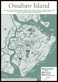
[Fig. 12] Ossabaw, the northernmost member of the historically defined Golden Isles, has a fascinating natural and human history to share. Humans have lived on Ossabaw Island for more than 4,000 years, enjoying and putting to use its rich salt marshes, freshwater ponds, ancient maritime forest, wind-swept dunes, and deserted white beaches. Shaped like a wishbone with marsh filling the middle, the island consists of 25,000 acres, of which 11,800 are upland and almost 10 miles are beach, making it roughly twice the size of Bermuda and counting total acreage the second largest barrier island on the Georgia coast. The island was the first acquisition of the Heritage Trust Act of 1975, which protects the island from overuse and development, but makes public access difficult and rare.
By state law, all of Georgia's barrier island beaches are open to the public, and Ossabaw is no exception. During daylight hours, the public is allowed to use the beach for hiking, picnicking, or shelling. However, the interior of the island is off limits to the public without permission. The management of the island is the responsibility of the Georgia Department of Natural Resources. As a heritage preserve, the island is open to individuals or groups for "natural, scientific, and cultural purposes based on environmentally sound practices."
Geologically, Ossabaw's two pieces of the wishbone consist of the Pleistocene western part fronting the interior marsh and the Holocene, eastern part facing the sea. The western piece is around 35,000 to 40,000 years old and the eastern piece is roughly 5,000 years old. The older the island, the more time it has had to develop richer soils to support a greater diversity of flora species, and the more likely it is to have developed new species.
 Atlantic
barrier islands tend to migrate westward toward the mainland. Rivers carry sediment
to the ocean. When the river currents meet the tides and the south-moving longshore
current, the sediment is pushed to the south, growing islands on their northern
ends, giving them a turkey-leg shape.
Atlantic
barrier islands tend to migrate westward toward the mainland. Rivers carry sediment
to the ocean. When the river currents meet the tides and the south-moving longshore
current, the sediment is pushed to the south, growing islands on their northern
ends, giving them a turkey-leg shape.
Geologists believe the two parts of Ossabaw are fused at the southern end, as opposed to the northern end, because of copious outflows of sediment from the Ogeechee River, which has slowed the northern end's westward migration. This effect from rivers is also seen among the islands north of Ossabaw and the St. Simons Island group.
Located 20 miles south of Savannah, the island fronts the salt marshes of Bryan and Liberty counties, but surprisingly is in Chatham County due to a wayward county line. Its northern, wide end looks over Ossabaw Sound (the largest sound on the Georgia coast, which is created by the Ogeechee River) to Wassaw Island, and Ossabaw's narrow, southern end looks over the St. Catherines Sound (created by the Jerico and Medway rivers) to St. Catherines Island. The island's relationship to the Ogeechee River is obvious in the fact that Ossabaw's first European name was Ogeche. Today's name of Ossabaw is considered one of the oldest place names in Georgia. The island's name is the anglicized spelling of the Guale village of Asapo found on the southern end of the island, believed to mean "yaupon holly bushes place."
Yaupon (Ilex vomitoria) is a common shrublike plant with red berries found on Ossabaw and all the other Georgia barrier islands. For ceremonies, Indians used yaupon berries to make a "black drink" that caused vomiting and visions. (CAUTION: Don't experiment with this plant. The leaves and berries are poisonous to humans and should not be eaten.) The island can't claim to be in the pristine natural condition of its neighbor to the north of Wassaw. Ossabaw's development history is typical of most Georgia coastal islands. Over its history of human occupation and use, virgin forests of live oak, water oak, laurel oak, and pine were cleared for timber and for growing sea island cotton, rice, and indigo and raising free-range livestock such as cattle, horses, hogs, and donkeys.
The island's natural communities have been allowed to recover from its 1700s–1800s plantation era under management by the Georgia Department of Natural Resources and the Ossabaw Island Foundation. Today, whatever barrier island natural communities you are looking for, they are represented on the island in abundance. Productive salt marshes and tidal creeks dominate the western side of the island, providing nursery grounds for a wide variety of fish and shellfish, such as trout, bass, oysters, crabs, and shrimp. Egrets and herons are frequently seen wading in the marsh, and vultures glide in their familiar circles overhead. Queen Bess Island, a marsh hammock, supports many nesting bird species, including the endangered bald eagle. Low-lying areas support red bay, American holly, and southern magnolia. The maritime forest consists mainly of live, water, and laurel oaks, and slash and loblolly pines. Eastern red cedar and cabbage palm are found in the upper marsh border and transition zone between marsh and maritime forest. The understory is dominated with abundant saw palmetto and wax myrtle, along with less frequent wild azalea, sparkleberry, beautyberry, sassafras, and yaupon. Catbrier, pepper-vine, and muscadine vines climb on branches of woody vegetation, bearing their fruit that provides important food energy to migrating songbirds.
Interior freshwater marshes, with cattails (Typha sp.) and bulltongue (Sagittaria sp.), are home to alligators, frogs, and small fish. Wading birds are common, and migrating waterfowl are also seen using the habitat. The island has noisy bird rookeries, where herons roost and raise their young. Freshwater ponds provide refuge to migrating waterfowl using the Atlantic flyway.
The sandy, dense interdune communities support a healthy population of lizards and snakes, including the Eastern diamondback rattlesnake, which grows to its maximum size due to the protected status of Ossabaw. Wax myrtle (Myrica cerifera) is common vegetation. Yucca earns its common name of Spanish bayonet with its succulent leaves with very sharp points. Other prickly plants worth avoiding are the spurge-nettle (Cnidoscolus stimulosus), and devil-joint (Opuntia pusilla), a small pricky pear cactus with barbed spines.
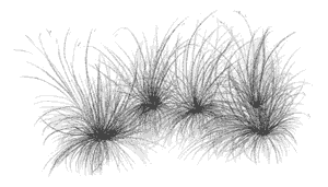
 Primary
dunes support flora communities consisting of beach panic grass (Panicum
amarum), salt meadow cordgrass (Spartina patens), beach elder (Iva
imbricata), sandspur (Cenchrus tribuloides), and the dune pioneering
sea oats (Uniola paniculata), Russian thistle (Salsola kali),
and morning glory (Ipomoea sp.).
Primary
dunes support flora communities consisting of beach panic grass (Panicum
amarum), salt meadow cordgrass (Spartina patens), beach elder (Iva
imbricata), sandspur (Cenchrus tribuloides), and the dune pioneering
sea oats (Uniola paniculata), Russian thistle (Salsola kali),
and morning glory (Ipomoea sp.).
Each summer Ossabaw's dunes attract approximately 160 nesting loggerhead turtles, which are drawn by primordial urges to its dark, sandy shoreline. The threatened piping plover winters on the shores of Ossabaw.
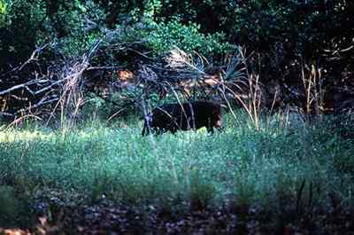
If you don't see deer or wild hogs as you travel the island, you aren't on Ossabaw. The island is home to an overpopulation of both, and they are frequently sighted crossing roads. One official estimates that 2,000 hogs and 1,000 deer roam the island. The hogs eat turtle eggs, which is a problem for the threatened loggerhead sea turtle. The first written record of deer hunting on the island was made in 1687, and hunting continues today. So popular is hunting on Ossabaw Island, the Georgia Department of Natural Resources is forced to hold a lottery each year, with lucky applicants receiving the right to shoot a prescribed limit of deer or hogs as well as spend the night on the island.
Ossabaw has a rich human history, with tales of Indian hunting parties, Spanish missionaries, rich plantations, African slaves, millionaire owners, and artist communes.
 The
first property transfer in the new colony of Georgia involved Ossabaw. Gen.
James Edward Oglethorpe made a land deal with Tomochichi, the mico of the Yamacraws,
receiving the tidewater region between Savannah and the Altamaha in exchange
for granting Ossabaw, St. Catherines, and Sapelo islands to the Indians in perpetuity.
The Indians made a subsequent deal, granting the hunting islands to Mary Musgrove,
an interpreter of mixed Indian and European parentage, who was considered princess
of the tribe. Musgrove, and her second husband Thomas Bosomworth, were granted
the Indian hunting islands "as long as the sun shall shine or the waters
run in the rivers, forever." Not much happened with the islands until Georgia
lifted its ban in 1749 on slavery, which was necessary to operate profitable
plantations in the south. Musgrove moved to establish plantations on her three
islands, but the Royal Trustees
protested the legality of her title to the islands. Despite the dispute, the
Bosomworths built a home and planted fields on St. Catherines, and raised cattle
on Ossabaw. After 11 years, the case was settled by granting them St. Catherines,
and Sapelo and Ossabaw were put up for public auction with the proceeds going
to the Bosomworths.
The
first property transfer in the new colony of Georgia involved Ossabaw. Gen.
James Edward Oglethorpe made a land deal with Tomochichi, the mico of the Yamacraws,
receiving the tidewater region between Savannah and the Altamaha in exchange
for granting Ossabaw, St. Catherines, and Sapelo islands to the Indians in perpetuity.
The Indians made a subsequent deal, granting the hunting islands to Mary Musgrove,
an interpreter of mixed Indian and European parentage, who was considered princess
of the tribe. Musgrove, and her second husband Thomas Bosomworth, were granted
the Indian hunting islands "as long as the sun shall shine or the waters
run in the rivers, forever." Not much happened with the islands until Georgia
lifted its ban in 1749 on slavery, which was necessary to operate profitable
plantations in the south. Musgrove moved to establish plantations on her three
islands, but the Royal Trustees
protested the legality of her title to the islands. Despite the dispute, the
Bosomworths built a home and planted fields on St. Catherines, and raised cattle
on Ossabaw. After 11 years, the case was settled by granting them St. Catherines,
and Sapelo and Ossabaw were put up for public auction with the proceeds going
to the Bosomworths.
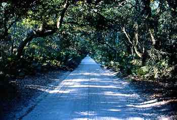
The island passed through several hands until John Morel, who became the first owner to clear and cultivate the property, bought it in the 1760s. Morel was from a successful family of South Carolina planters. He built a home on the north end and planted an avenue of Live Oaks that remains today and is considered to be the longest, oldest dirt road still in use in America. The Morels planted indigo, cotton, and rice on the island. Indigo production was especially labor intensive, requiring hundreds of slaves to settle on the island. Morel divided the island into three parts for management purposes. When John Morel died, his three sons each received a different part: Bryan Morel inherited North End Place, Peter Henry received Middle Place, and John II was deeded the South End. The names of the three parts are still used today.
After the War of 1812, sea island cotton was the dominant crop and led to great prosperity among plantation owners. The island was abandoned by the Morels during the Civil War, and the Union blockaded the sound, built batteries on the north end of the island, and stationed a small number of troops here. After the Civil War, the property transferred hands until it was almost entirely owned by the Wanamakers of Philadelphia, who used the island as a hunting club.
In the early twentieth century, Ossabaw passed through different owners until Dr. H.N. Torrey of Grosse Point, Michigan, purchased it in 1923 for a winter residence. It took two years to build the family's vacation home at the North End, which became a massive, two-story stucco residence in a Spanish style, with Bermuda pink walls and a Castilian tile roof, harkening back to the days of the Spanish empire on the Georgia coast. In the two-story, chapel-like wood beam living room is a large, centrally located fireplace built of ballast stone. Near the mansion, several other support buildings were constructed, and beautiful gardens were maintained on the grounds. The island again saw its share of parties and famous visitors. Henry Ford is the first signature in the mansion's guest book.
Ownership of the island eventually passed down to Dr. H.N. Torrey's daughter, Eleanor Torrey (Sandy) West and some nieces and nephews. In 1961, Sandy West created The Ossabaw Foundation, which launched many unique programs on the island, such as the Ossabaw Island Project. This interdisciplinary program supported recommended individuals "of creative thought and purpose in the arts, sciences, industry, education, and religion" to come to the island to share their ideas with other creatives and pursue their work without interruption. West herself is a creative artist who has produced children's books, exhibited watercolors, and made documentary films.
Renowned creatives from architect Robert Venturi to writer Annie Dillard stayed at the mansion during the program's run from 1961–1982. Another program launched in 1970, called the Genesis Project, was a rustic experiment in cooperative living at Middle Place, replete with a tree house with a marsh view and solar-powered sauna, among other buildings. Here around 10 students from colleges around the country shared community tasks such as gardening, milking their cow, and maintaining the buildings while they studied the island's environment and history and pursued personal artistic projects, such as making pottery from the island clay.
In the late 1970s, West and her relatives sold the island to the state to keep it from developers. The Nature Conservancy of Georgia purchased an option in 1977, and transferred it to the state in 1978. Valued at $15 million, the island sold for $8 million, with the remaining amount being a charitable gift from West and her family. The State of Georgia provided $4 million, and the remaining half of the purchase price was a donation from The Coca-Cola Company President Robert W. Woodruff, which was the largest private grant for conservation at that time. The island became the first heritage preserve in Georgia [Fig. 12(2)] that allows the conservation of land for specifically stated purposes, and in this case it is to be used in an ecologically sound way for scientific and cultural purposes. West retains a life estate, including the Torrey mansion and 24 acres.
The island has more than 100 miles of dirt roads and trails. At or near the North End of the island is a dock, the Torrey mansion, tabby slave quarters, the island manager's quarters, and one of the first pre-fabricated houses ever built. Brought from Philadelphia where it was exhibited at the Philadelphia Exposition of 1898, the state plans to rehabilitate the historic two-story wooden structure with grants through the Georgia Heritage 2000 program. Feral horses and Sicilian donkeys roam the area. Cotton was grown at the North End.
Tabby ruins of indigo plantations are found at Middle Place, along with several buildings from the Genesis Project period of the island. A huge, ancient live oak, perhaps 600 years old, is found near here. The South End is home to Department of Natural Resources hunting quarters and a dock for arriving sportsmen. A causeway leads across the interior marshes to the Holocene dune ridges of the eastern half of the island. The beach is wild and deserted, and features some of the best shelling found off the Georgia coast. Like the rest of the island, the beach continues to change and be shaped by natural forces. In the 1970s, island officials could drive the entire length of the beach, but today, a tidal creek has divided the beach at Bradley Slough.
Read and add comments about this page