 St.
Catherines Island St.
Catherines Island
St.
Catherines Island St.
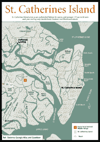
Catherines Island [Fig. 15] While the interior of St. Catherines Island is not open to the general public, this important island needs to be described due to its ecological and historical significance. By state law, all of Georgia's barrier island beaches to the high tide line are open to the public, including St. Catherines. During daylight hours, the public is allowed to use the beach for hiking, picnicking, or shelling to the high-tide line. However, the interior of the island is off-limits to the public without permission.
The island is 10 miles long and ranges from 1 to 3 miles wide, with more than half of the island's 14,640 acres composed of tidal marsh and wetland meadows and ponds. The 6,780 acres of upland are densely forested, with pine and live oak being the predominant species. More than 11 miles of beautiful, white sandy beaches wrap around the eastern side of the island. Like most of the other islands on Georgia's coast, St. Catherines has Pleistocene and Holocene segments, with the older, landward part possessing richer soils that support lush subtropical vegetation and the younger, beach section fronting the sea. Where the two epochs meet at the northern end, a dramatic 25-foot bluff is formed, which was used by Guale Indians as an observation point and may be the most unusual geologic feature on any of the Georgia barrier islands. The island serves as an undisturbed habitat for osprey, and averages 119 sea turtle nests each year, trailing only Cumberland, Ossabaw, and Blackbeard islands in popularity with the endangered reptiles.
Owned by the St. Catherines Island Foundation, the island's interior is operated for charitable, scientific, literary, and educational purposes. The foundation aims to promote conservation of natural resources, the survival of endangered species, and the preservation of historic sites, and to expand human knowledge in the fields of ecology, botany, zoology, natural history, archaeology, and other scientific and educational disciplines.
 In
this capacity, the island serves as a refuge of last resort for endangered species
from around the world. It also has been the scene of innovative archeological
work that has revealed much information about the mysterious Spanish mission
period on the Georgia coast. The island also hosts environmental research projects
on a wide variety of subjects such as beach erosion, mating and flocking habits
of certain birds, and behavior and population densities of native mammals, lizards,
and insects.
In
this capacity, the island serves as a refuge of last resort for endangered species
from around the world. It also has been the scene of innovative archeological
work that has revealed much information about the mysterious Spanish mission
period on the Georgia coast. The island also hosts environmental research projects
on a wide variety of subjects such as beach erosion, mating and flocking habits
of certain birds, and behavior and population densities of native mammals, lizards,
and insects.
The island has a variety of subtropical ecosystems that are naturally adapted to the management of endangered species from similar climates around the world, which has led to the establishment of the St. Catherines Island Wildlife Survival Center. Begun in 1974 by the New York Zoological Society with a pilot project of 10 gemsboks in a 5-acre pasture, the program has captively bred many exotic species of birds, mammals, and reptiles. The island serves as a type of Noah's Ark, where breeding colonies can be established to build up numbers of the rare animals, which are then returned to zoos or the wild. Some of the animals that have been raised and protected on the island include Grevy's zebras, ring-tailed lemurs, dama gazelles, St. Vincent parrots, rhinoceros hornbills, Aldabra tortoises (a very rare tortoise related to the Galapagos tortoise), Florida sandhill cranes, and Jackson's hartebeests. More than 14 zoos participate in the program.
Today the island is dedicated to scientific research, but in earlier times it was the busy center of political activity on the Georgia coast. Registered as a National Historic Landmark in 1970, St. Catherines was a favorite hunting ground of Indians, and a settlement called Guale in the center of the island served as headquarters for their chief, also named Guale. The Guale were the last in a long line of Indians stretching back 4,000 years that appreciated the island's natural resources. Here, the Spanish established a mission and garrison called Santa Catalina de Guale, from which the island takes its name. Button Gwinnett, a signer of the Declaration of Independence, established a plantation on the island. After the Civil War, the capital of a black separatist sea island kingdom was established here.
Most history books about Georgia begin the story with English Gen. James Edward Oglethorpe sailing up the Savannah River in 1733. This neglects the influence of the Spanish, who built missions on the Georgia coast 207 years before Oglethorpe ever sighted the barrier islands of Georgia. The first mission was established by Lúcas Vásquez de Ayllón in 1526, preceding St. Augustine by 39 years, Sir Walter Raleigh's "lost colony" by 60 years, the English at Jamestown, Virginia by 81 years, and the Pilgrims' landing on Plymouth Rock by 94 years. The Ayllón mission failed within a year, and its exact location remains a mystery, but historians studying maps believe the location of the site was somewhere near St. Catherines and Sapelo islands. Despite Ayllón's failure, the Spanish under Pedro Menendez tried again in 1565 from their base at St. Augustine and succeeded in establishing missions across the Southeast and Florida, and at one time they had approximately 70 Franciscan missionaries serving 25,000 Indians at 38 missions in the Southeast.
In 1566, Menendez explored the Georgia coast and met with an Indian chief named Guale on St. Catherines. ***View an author's note about the pronunciation of "Guale." During early European colonization, the Guale chiefdom extended from the mouth of the Ogeechee to the mouth of the Altamaha River and included the islands of Ossabaw, St. Catherines, and Sapelo. The Guale spoke Muskogean. A different chiefdom, the Timucuan-speaking Mocama, extended south of the Altamaha to the St. Johns River and inhabited St. Simons, Jekyll, and Cumberland islands. For many years, writers have erroneously asserted that the Georgia coast was called Guale. In truth, the coast was divided by two Indian chiefdoms and there was no original Indian name for the Georgia coast.
On St. Catherines, the Spanish established a mission, Santa Catalina de Guale, which in 1587 was the northernmost outpost of the Spanish Empire in America. In the struggle for the New World, the English pushed south from Virginia and the Spanish pushed north from Florida, which made Georgia the frontline of the battle. The area between Charleston, South Carolina and St. Augustine, Florida, was called "the debatable land" for the territorial dispute. Georgia was not completely in English hands until Oglethorpe defeated Spanish troops on St. Simons Island at the Battle of Bloody Marsh in 1742 and a peace treaty was subsequently signed.
In 1597, a Guale Indian named Juanillo led an uprising against the Spanish, killing five Franciscan friars and destroying missions along the Georgia coast. On St. Catherines, two missionaries were killed and the settlement burned. Juanillo was captured and killed, and eventually the Spanish rebuilt. The next 80 years were known as the Golden Age of Spanish Missions, with at least 15 established in Georgia, some located farther inland. Spanish hegemony remained relatively unchallenged in the Southeast until 1670, when the British established Charles Town in South Carolina. This sparked almost a century of heated conflict over "the debatable land." In 1680, the English with Indian allies attacked the mission on St. Catherines. The Guale were successful in repelling their attackers, but abandoned the mission, which was left to the ravages of time and disappeared under shifting sands and dense vegetation. This marked the end of Spanish settlement on the Georgia coast as well as the end of the Guale Indians, who were to vanish without much known about them.
Despite the long period of Spanish habitation on the Georgia coast, previous to successful efforts on St. Catherines, not a single mission site in Georgia had been identified archeologically. Many believed that tabby ruins found on various islands belonged to the early Spanish missionaries, but it was later discovered that they all belonged to the plantation period. The Spanish missions were built of wattle and daub: Timbers were set vertically, and cane was woven horizontally between them. Then the wattlework was plastered (daubed) with a mixture of sand, mud, and plant fibers. The roofs were covered with palmetto leaves. This made the structures entirely biodegradable. When left to the elements, the structure would wash away, making archeology very difficult if not impossible. But luckily for archeologists searching for the St. Catherines mission, it was burned, which effectively hardens the wattlework the way a clay pot is baked in a kiln, leaving solid evidence. But how to find it under a foot of dirt and dense vegetation over an area equivalent to 30 football fields?
American Museum of Natural History archeologist Dr. David Hurst Thomas, exploring the island on a foundation project since the mid-1970s, used remote sensing equipment to find the lost mission. When subjected to intense heat, iron particles will orient north. The settlement's marsh mud walls contained some microscopic iron particles that were thus altered when the mission burned. Using a sensitive magnetometer, Thomas was able to identify the mission site. There he found more than 400 graves of Christianized Indians, many artifacts, and other clues that have yielded much fresh information on the Guale Indians and the Spanish mission period.
St. Catherines, along with Ossabaw and Sapelo, was involved in the first property transfer in the new colony of Georgia. Gen. James Edward Oglethorpe granted Ossabaw, St. Catherines, and Sapelo islands to the Indians in perpetuity for property rights to the tidewater region between Savannah and the Altamaha River. The Indians made a subsequent deal, granting the hunting islands to Mary Musgrove, an interpreter of mixed Indian and European parentage who was niece of the Indian chiefs and considered princess of the tribe. When Georgia lifted its ban in 1749 on slavery, Musgrove and her second husband Thomas Bosomworth established plantations on her three islands. The legal status of her ownership of the islands was protested by the Royal Trustees, and remained in dispute for 11 years. Nonetheless, the Bosomworths built a home and planted fields on St. Catherines, and raised cattle on Ossabaw. In 1760, the case was settled by granting them St. Catherines, and Sapelo and Ossabaw were put up for public auction with the proceeds going to the Bosomworths.
Mary Musgrove died soon after the decision, and Thomas Bosomworth remarried and sold the island to Button Gwinnett in 1765. Gwinnett, a failed businessman who fled creditors in England for the New World, purchased the island entirely on credit. In Georgia, he earned the reputation as a hotheaded character who had trouble staying out of debt. As the colonists debated the push for independence, Gwinnett supported popular suffrage, unlike the power elite of Savannah, the Christ Church Whigs, who believed only the landed aristocracy should be allowed to vote. His opposition to Christ Church endeared him to the Puritans of St. Johns Parish who wanted to break their northern neighbor's hold on power in the colony. (Savannah's Christ Church was so important to the town that the parish was named Christ Church Parish.) He showed aptitude for politics, and served as speaker of the Commons House of Assembly, president of the Council of Safety, representative to the Second Continental Congress, and commander-in-chief of the armies of Georgia. He helped draw up Georgia's first constitution, redrawing the state's parishes into counties. A rivalry developed between Gwinnett and Gen. Lachlan McIntosh of the Georgia Army, who was a coastal planter and a member of Christ Church. Gwinnett said McIntosh's brother aided Loyalists and relieved McIntosh of his command. At a hearing to decide if Gwinnett's action was justified, McIntosh called Gwinnett a "scoundrel and lying rascal." Gwinnett challenged McIntosh to a duel, which was held on the outskirts of Savannah on May 16, 1777. Both were shot, but Gwinnett died of his wounds on May 19. McIntosh was reassigned to Valley Forge where he served with distinction under George Washington. Both Gwinnett and McIntosh eventually had counties named for them or their families. Gwinnett remains a mystery man, with no known reliable portrait of him in existence, and his rare signature fetches more than $100,000 from collectors. Gwinnett left a wife and child in debt, and the island was put on the auction block. Ownership returned to Thomas Bosomworth, who moved back to the island and lived there until he died and was buried on the island.
A house on the north end of the island, called the Old House, is believed to have belonged to Button Gwinnett. The house and tabby slave cabins from 1800 are used by the foundation.
After the Civil War, General Sherman created an independent state for freed slaves consisting of the sea islands from Charleston, South Carolina, to northern Florida. In 1865, establishing himself as virtual king of this state was Tunis Campbell, who reigned over a government with a legislature, a court, and a 275-man army from his capital at St. Catherines Island. Whites called Campbell "the most feared man in Georgia." Congress repealed Sherman's directive and Federal troops forced Campbell off the island in 1867 to McIntosh County, where he continued his "rule." (Today, he is remembered with a June festival in Darien every year. See Appendix D.)
The island changed hands over the years, with various families growing cotton and using the island as a private hunting preserve. Howard Coffin, who owned Sapelo Island and developed Sea Island, once owned St. Catherines and restored and enlarged Gwinnett's Old House.
Edward John Noble of New York purchased the island in 1943 and used it to raise purebred Angus cattle. He died in 1958, and in 1968 the island was transferred to the Edward J. Noble Foundation, which later conveyed the island to the St. Catherines Island Foundation.
The North and South Newport and Medway rivers that define Liberty County's boundaries and coastline are productive and popular fisheries. Common inshore catches include southern kingfish (also called whiting), spotted seatrout, sheepshead, striped bass, black and red drum, southern flounder, skate, and Atlantic croaker. Tarpon and shark are caught in St. Catherines Sound, where the large fish patrol the deep waters looking for prey.
Liberty County has two major marinas near the coast and both are located on Colonel's Island: Yellow Bluff Fishing Camp and Colonels Isle Marina. Yellow Bluff Fishing Camp provides access to the Medway River and St. Catherines Sound via Ashley Creek. It offers gas, hoist, bait and tackle, refreshments, and dry storage. (912) 884-5448. Colonels Isle Marina provides access to the North and South Newport Rivers, or downstream to St. Catherines Island and Sound. It offers gas and diesel, hoist, bait and tackle, camping, lodging, and dry and wet storage. A public boat ramp is found in Sunbury. (912) 884-5819.
Most restaurant options are located in Hinesville, but closer to the coast and I-95 is Holton's Seafood Restaurant, I-95 and US 84, which is known for its fried shrimp and other local delicacies. Open for lunch and dinner, 7 days a week. Moderate. (912) 884-9151.
Read and add comments about this page