 Caribou
Wilderness
Caribou
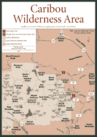
Wilderness [Fig. 8, Fig. 9, Fig. 10, Fig. 11, Fig. 12] The 1.2 million-acre forest, established in 1905, is a kind of California crossroads where the Sierra Nevada's northern boundary meets the Cascade Range from the Pacific Northwest and the Great Basin from the East. The southern part of Lassen is in the Sierra, and the central and northern portions are in the Cascades. The eastern Lassen forest areas are in the Great Basin, which is on the more arid eastern side of the Sierra.
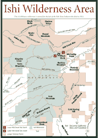
Visitors have the opportunity to learn the story of the last survivor of the Yahi Yana Native American tribe in the Ishi Wilderness, which contains about 41,000 acres. The forest in the wilderness has high granite countryside as well as lava-covered geologic ridges and meadows. The granite supports some lakes, but the volcanic soil is porous and cannot hold enough water for lakes.
Lassen National Forest surrounds 106,000-acre Lassen Volcanic National Park. In the park, 10,457-foot Lassen Peak erupted in the early part of the century with a spectacular blast seen for miles around.
Just east of the park, the Caribou Wilderness stretches for 40,000 acres and includes high-country lakes, wildlife, and wildflowers in midsummer.
Caribou
Wilderness [Fig. 8] Just east of the national park, the Caribou Wilderness is a gentle, rolling plateau with crater peaks, cinder cones, and large depressions that have evolved to timber-lined lakes. The headwaters of the Susan River begin in the Caribou, percolating up through the porous volcanic aquifer.
The volcanic peaks include Swain Mountain, Bogard Buttes, Prospect Peak, Ash Butte, Red Cinder Cone, and Mount Harkness. Red Cinder is the highest point at 8,370 feet.
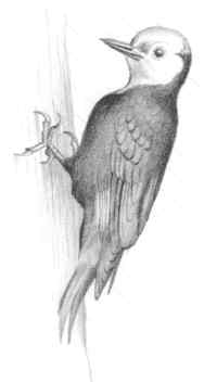
The obvious large natural features—volcanic ridges, conifer tree groupings, and streams—sometimes overshadow the smaller parts of the ecosystem in Caribou and other California wildernesses. One of the more interesting microcommunities is on the forest floor where fungi grow.
As the sanitary agents of the forest that consume dead organic matter, fungi spread on the floor of a conifer area. The cup fungus (Sacrosphaera coronaria), for instance, can be found in the Caribou, along with man's hair (Boletus edulis) and narrow-headed morel (Morella angusticeps). Fungal spores blow in on the winds and take up residence at the foot of trees.
Along some trails in the Caribou, hikers will see a timber-destroying pore fungi called the red-belt fomes (Fomes pinicola). Look for the white and yellow fungi on the bark of such trees as the white fir (Abies concolor).
 Though
susceptible to fungal infection, white firs have developed an ability to
exist in shaded, crowded conditions. Look for them in dense stands where
they grow slowly until larger trees fall aside and allow the sunshine to
peek through. Scientists believe the shade adaptation occurred over thousands
of years as the tree competed for sunlight with other conifers.
Though
susceptible to fungal infection, white firs have developed an ability to
exist in shaded, crowded conditions. Look for them in dense stands where
they grow slowly until larger trees fall aside and allow the sunshine to
peek through. Scientists believe the shade adaptation occurred over thousands
of years as the tree competed for sunlight with other conifers.
Snow stays late in spring in this wilderness. Often, the Caribou, which is about 40,000 acres, does not open until July, and the area is still marshy after the snowmelts, meaning mosquitoes are out in the morning and evening.
[Fig. 8(1)] Emerald, Rim, and Cypress lakes may be the most beautiful attractions in the Caribou. Campsites are not developed at Rim Lake and in much of this area, but Cypress Lake does have many places where people can camp. This hike to all three lakes can easily be done in half a day, so camping may not be necessary.
Vistas of Lassen Volcanic National Park and other parts of the surrounding mountains can be enjoyed from nearby North Caribou Peak, which is less than 1 mile from Cypress Lake. Swimming, camping, and nature walks are popular activities in this area.
[Fig. 8(2)] This trail has a high immediate-gratification factor. It is not long before hikers reach Triangle Lake and the cool water that can be so refreshing on a warm day in the Cascades.
The first lake, Triangle, is only about 2 miles from the trailhead. The loop trail around the lake is a little more than 1 mile and well worth the extra time. The pine and fir belt in the area makes it an eye-catcher.
The smaller Twin Lakes are less than 1 mile away, beyond a lush meadow. Turnaround Lake is about another mile. With modest ridges in the backdrop, the lake offers many places where campers can stay and another trail to circle the lake.
 Ishi
Wilderness
Ishi
Wilderness [Fig. 9] The 41,000-acre Ishi Wilderness is in the Cascade foothills, just north of the Sierra batholith. Basaltic outcroppings and pillar lava formations are common here. It is about 8 miles southwest of Lassen Volcanic National Park, and it is another mostly volcanic feature that will interest geologists and other visitors alike.
East-west ridges abound with river canyons slicing through the countryside. Dense islands of ponderosa pine (Pinus ponderosa) grow on terraces left after rivers cut the canyons. The ponderosa also is known as the yellow pine, referring to the pale color of bark on the mature tree. Black oak (Quercus kelloggii), sugar pine (Pinus lambertiana), and white fir (Abies concolor) also are found with the ponderosa.
Below the terraces and ridgelines this is foothill territory with chaparral communities—dense groupings of plants with deep root systems that can survive where moisture is limited.
The chaparral communities of the Ishi have some manzanita (Arctostaphylos) and spice bush (Calycanthus occidentalis). They are not as common here as they are south of Yosemite National Park because these plants adapt to drier conditions. Northern Sierra forests are generally wetter than the southern forests.
There are two types of manzanita found on dry, south-facing slopes in Ishi. They are the white-leaf manzanita (A. viscida), which has white branches and sticky, rose-colored flowers, and the Indian manzanita (A. mewukka), which has a deep red bark and smooth gray-green leaves. The porous volcanic soils are conducive to growth, allowing the root systems of these and other foothill plants to develop extensively.
More common shrubs in Ishi include bitter gooseberry (Ribes amarum), silver lupine (Lupinus albifrons), and coyote brush (Baccharis pilularis). The more common wildflowers, seen in spring and summer, are Carolina geranium (Geranium caroliniana), tower mustard (Arabis glabra), and miner's lettuce (Montia perfoliata).
 Ishi
is named for a Yahi Yana Indian who was the last survivor of a tribe that
flourished in the area more than 3,000 years ago. European settlers killed
most of the Yahi after 1850. Ishi, which means "man" to
the Yahi, hid for many years in this wild and desolate place with only a
few people as company.
Ishi
is named for a Yahi Yana Indian who was the last survivor of a tribe that
flourished in the area more than 3,000 years ago. European settlers killed
most of the Yahi after 1850. Ishi, which means "man" to
the Yahi, hid for many years in this wild and desolate place with only a
few people as company.
After becoming separated from his companions, Ishi walked out of the woods into civilization in 1911. No one spoke his language. A University of California at Berkeley professor heard about Ishi and knew enough of the language to communicate with him. The professor moved Ishi to Berkeley. Ishi died four years later of tuberculosis after living in a basement in a Berkeley museum where he was a janitor.
The Tehama deer herd, the largest mule deer (Odocoileus hemionus) herd in California, spends winters in this foothill area. The herd is estimated to number between 40,000 and 60,000 deer. The deer spend winters in the area to forage for food; vegetation usually is not available in higher elevations. Such winter migrations are common for deer and many other animals in the Sierra.
The mountain lion (Felis concolor), coyote (Canis latrans), and black bear (Ursus americanus) are also inhabitants. Rock cliffs are nesting sites for raptors such as hawks, eagles, falcons, and owls.
[Fig. 9(1)] The foothill wildflowers and the lava-rock canyon are the main attractions. This walk will take visitors through areas that have burned in the last decade, showing how fire is essential to California forests by helping to clear excess brush and regenerate.
When the brush is burned back from fire beneath the understory of trees, more room is made for flowers and low-growing vegetation. This pattern is familiar throughout the Sierra and is discussed in detail on page 14.
Wildflowers along the trail include California milkmaids (Dentaria californica), fan violet (Viola sheltonii), and Chinese caps (Euphorbia crenulata). The Chinese caps are particularly interesting because they have no petals. They were named Chinese Caps because they have glands that resembling devil heads or ancient Chinese caps. They can be found in partial shade.
Mill Creek is a year-round stream with meadows and cool water. The rock in the area is basaltic, probably part of lava flows that occurred about 20 million years ago.
[Fig. 9(2)] The steep Mill Creek Canyon is a sight-seeing delight, but poison oak (Toxicodendron diversiloba) can ruin a visit quickly. This hike is simply the south side of the canyon mentioned in the Lower Mill Creek Trail, north.
In the foothill areas, there is always the problem of poison oak, which can cause skin irritations for many people. It is pervasive in the Sierra from 100 feet to 5,000 feet in elevation, but it can be literally everywhere at elevations around 2,000 feet, which is about the elevation of this hike. The main lesson is to learn what it looks like and stay on the trail when approaching big thickets of underbrush. Wear long pants.
 Lake
Almanor National Recreation Trail
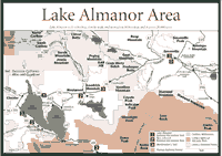
Lake
Almanor National Recreation Trail [Fig. 10(1)] Some of the best wildlife viewing in the Lake Almanor basin can be found along the Lake Almanor National Recreation Trail, which runs 9.5 miles along Lake Almanor. The trail is 10 feet wide and paved, so it is not a typical forest trail. It is on the west side of the lake, and begins at Humbug and Humboldt roads, running south to the Lake Almanor Campground. Expect to find people riding bikes or roller blading along the trail. The slopes are gentle and the hiking is easy.
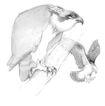
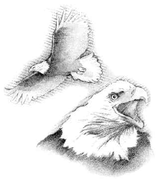
Look for osprey (Pandion haliaetus), the fish hawk that lives around water and hunts by plunging feet-first into the water for fish. Bald eagles (Haliaetus leucocephalus), the white-headed emblem of the United States, occasionally can be seen from the western shore. Eagles are known to steal meals from osprey or other wildlife.
On the shore and in low, marshy meadows around the lake, the English sundew (Drosera anglica), northern bugleweed (Lycopus uniflorus), buckbean (Menyanthes trifoliata), and tofieldia (Tofieldia occidentalis ssp. occidentalis) can be found. Among these herbs, the English sundew is relatively rare in California because it requires more rainfall and cooler weather than the Sierra normally receives in many parts of the range.
The geology around the lake is fascinating as well, because the lake is actually over the northern boundary of the Sierra Nevada. Without close geological examination of the rocks, it would be difficult to see that the Sierra's northern boundary cuts through this trail and right into Lake Almanor. The Sierra block submerges below the younger Cascade volcanics.
The boundary, well-known to geologists but not easy for visitors to spot, runs just north of Oroville and continues through Almanor—the only hint being the change from ancient sedimentary rocks to younger volcanic rocks.
The lake, on the other hand, is easy to distinguish from natural lakes. It forms behind a concrete dam. The dam was built after the turn of the century when a power company built this hydroelectric facility.
It is a bit of an understatement to call Lake Almanor just another hydroelectric facility. The lake was made in 1914 by the Great Western Power Company at a time when hydro was the futuristic power source. It was named by combining the names of the three daughters of the company's vice president, Guy C. Earl. His daughter's names were Alice, Martha, and Elinore. The first two letters of Alice and Martha were joined with three letters of Elinore.
But this lake is something more than a hydro facility named after three daughters of a power company executive. It is a recreation area filled with swimming beaches, fishing spots, and wildlife viewing.
The lake is 13 miles long, 6 miles wide, and about 90 feet deep at its deepest, covering about 28,000 acres. By California standards, it is a larger-than-average reservoir with 1.3 million acre-feet of water. (An acre-foot of water is about 326,000 gallons.) To qualify as large in California, a reservoir should hold between 2 and 3 million acre-feet of water.
 The
Bizz Johnson National Recreation Trail
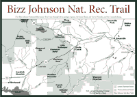
The
Bizz Johnson National Recreation Trail [Fig. 10(2)] People use the Bizz Johnson National Recreation Trail for bicycling, hiking, horseback riding, and cross-country skiing. It is the outdoor recreation corridor between Susanville and Westwood, giving people the chance to go more than 25 miles or take smaller trips.
As it winds through the rugged Susan River Canyon, the trail crosses the river 12 times on bridges and trestles and passes through two tunnels. The trail runs through three geologic regions, the Great Basin, the Sierra Nevada, and the Cascade Range. Along the way it passes through a semi-arid canyon to a dense forest of pine and cedar.
The flora changes as you move through the three geologic areas. The dense pine and cedar are part of the Sierra Nevada and the Cascade Range, which receive more rainfall on their western slopes. The precipitation is caused as storms traveling west to east gain altitude to clear the mountains.
The coniferous trees include the grey pine (Pinus sabiniana), the aromatic incense cedar (Libocedrus decurrens), and the Jeffrey pine (Pinus jefreyi). Watch for the pygmy owl (Glaucidium gnoma), the smallest Sierra owl. Unlike many other owl species, this owl calls and moves around by day. After a meal, it will perch in the open and groom itself.
 Things
change dramatically on the eastern side of the Sierra crest. This is the
Great Basin. More arid conditions result from less rain because storms have
dropped much of their moisture on the western side of the mountains. In
the Great Basin area, the flora includes the huckleberry oak (Quercus
vaccinifolia) and bush chinquapin (Castanopsis sempervirens),
which adapt to the drier conditions and high elevation. The dusky flycatcher
(Empidonax oberholseri) and the green-tailed towhee (Chlorua chlorua)
can be seen among the sagebrush and bitterbrush on the eastern side
of the Sierra, too.
Things
change dramatically on the eastern side of the Sierra crest. This is the
Great Basin. More arid conditions result from less rain because storms have
dropped much of their moisture on the western side of the mountains. In
the Great Basin area, the flora includes the huckleberry oak (Quercus
vaccinifolia) and bush chinquapin (Castanopsis sempervirens),
which adapt to the drier conditions and high elevation. The dusky flycatcher
(Empidonax oberholseri) and the green-tailed towhee (Chlorua chlorua)
can be seen among the sagebrush and bitterbrush on the eastern side
of the Sierra, too.
Along the Bizz Johnson, the human-made sights are interesting as well. One of them is the 25-foot carved redwood statue of Paul Bunyan near the Westwood side of the trail, which follows an old Southern Pacific Company rail line.
The statue is a monument to the 1930s' boomtown business called the Red River Lumber Company of Westwood, the largest pine mill in the world. At Westwood trailhead's railroad station kiosk, interpretive displays of the Westwood museum bring back an era when the woods and the town of Westwood bustled with the sounds and activities of logging and railroading.
As for the trail following the historic rail line, it runs from Susanville to Mason Station. For the first dozen miles, the trail follows the Susan River.
The old rail line was built in 1914 to serve the newly developed logging community of Westwood. The Fernley and Lassen Railroad was heavily used to haul logs and transport passengers for more than four decades.
The western half of the Fernley and Lassen Branch line was alive with logging camps, spur lines, and switching stations. The features can now be seen along the trail marked by replicas of station signs and explained in interpretive signs.
The rail line was first operated by Central Pacific, and later by Southern Pacific. It provided a much-needed connection from the Westwood mill in Lassen County to the railroad's main line in Fernley, Nevada. From Fernley, the milled lumber products were shipped to markets throughout the country and around the world.
The Westwood Mill gradually declined and the railroad died. The last trains ran on the Fernley and Lassen branch line in 1956. For 20 years the railroad lay unused.
In 1978, Southern Pacific obtained legal permission to abandon the line. The Bureau of Land Management, with the support of the U.S. Forest Service and many community groups, then started the rails to trails conversion. The name Bizz Johnson was attached to the trail to honor Congressman Harold "Bizz" Johnson, who worked on this and other public projects during his 22-year tenure in Congress.
There are places to cross-country ski—especially on the Bizz Johnson Trail. In other sections of this Northern Sierra forest, snowmobiling is very popular. There are at least six areas where the brisk breeze and the fresh snow are sampled most often by people on snowmobiles.
The six places to snowmobile include Fredonyer and Bogard snowmobile areas in the Eagle Lake Ranger District in the northeast part of forest; Morgan Summit, Jonesville, and Swain Mountain snowmobile areas in the Almanor Ranger District in the central part of the forest; and Ashpan Snowmobile Area in Hat Creek Ranger District to the north of Lassen Volcanic National Park.
Each area has its own groomed and ungroomed areas. The Bogard area, for instance, has 80 miles of trails, and the groomed trails are considered easy to follow because they follow forest roads. There is one 38-mile trip that ends near Eagle Lake where bald eagles (Haliaetus leucocephalus) are sometimes sighted. Some routes are shared with cross-country skiers.
For cross-country skiing, the best areas along the Bizz Johnson Trail are on the upper 18.5-mile segment, west of Highway 36, and on the Devils Corral area. Elevations from 4,760 feet to 5,500 feet, northern exposures, and shading provide the most reliable snow conditions.
A segment of the Bizz Johnson Trail recommended for cross-country combines snowed-in road skiing from Highway 44 to Goumaz (3 miles) with trail skiing from Goumaz to Highway 36. This 9-mile segment affords a gentle downhill slope with good views of the Susan River and Diamond Mountain.
The lower 7 miles of trail from Highway 36 east to Susanville can be skied after major storms; the lower elevations and southern exposures cause the snow conditions to decline quickly in this section. The section also has two tunnels (800 and 450 feet), which require walking.
[Fig. 10(3)] On an afternoon of driving, people can follow more than 67 miles of an ancient trail started by the Mountain Maidu Indians centuries ago. The trail runs from Quincy to Susanville through the Lassen National Forest, just at the northern edge of the Sierra Nevada.
As the Maidu legend goes, the mountain lands were created after a great flood. Following the flood, the "Worldmaker" started on a journey to look at the land. He followed the trail that would become the major artery for Maidu people.
The Worldmaker encountered rugged terrain and the mythical "coyote," a literary figure that put obstacles in the way of the Worldmaker. The Worldmaker had to overcome monsters and smooth the rugged mountain landscape for the Maidu people.
The driving tour takes visitors to places where it is obvious nature has conspired to bring this tale to life. The ridges, ravines, rugged countryside, and streams would have offered obstacles to the progress of the Worldmaker. The landscape, aided by the coyote's mischief, made a formidable challenge. There are 15 scenic locations with views of streams, waterfalls, rock features, and other sights. Most of them have convenient turnouts and places to park.
If driven without many stops, the tour could be completed in two hours, but there are several walks that are worth taking. Only 0.8 mile from Quincy, the Gansner Park-American Valley offers a walk through marshes and streams, giving visitors an idea of the swamps that once covered the area. The swamps were deep with native grasses and filled with insect life. Streams carrying sediment have filled many areas to the point that only shallow marshes now exist instead of swamps.
About 1.5 miles from Quincy, Indian and Spanish creeks meet the Feather River at a traditional Maidu campsite. The Maidu would collect salmon, crayfish, and eel each spring.
A short hike over fairly steep terrain is required to see Thundering Falls about 0.8 mile north of Soda Rock. A picnic table is available at the overlook. The turnout for this walk is north of Indian Falls, and parking is available on the east side of Highway 89.
Fifteen miles and several stops later, Wolf Creek and Whitegrass Mountain can be found near Highway 89. The area provides the rare habitat for bear grass plant or whitegrass (Xerophylum tenax), which the Maidu used to make white patterns in baskets. Bear grass still is gathered by Maidu people for their well-known basket weaving.
About 3.3 miles later on Highway 89 at Highway 147, turn north and drive 0.5 mile to the scenic overlook at Big Meadow in the Lake Almanor area. Prior to building this hydroelectric lake, Big Meadow was an open, grassy valley. The Worldmaker, as legend goes, encountered a giant frog monster and little devils, which were turned into boulders. Lassen Peak, in the neighboring Lassen National Park, is visible from here.
Drive another 11 miles on Highway 147, turn east on Highway 36 for 20 miles, make a few other stops on the way. Cross the Susan River Bridge, turn at the trailhead for the Bizz Johnson National Recreation Trail, and walk along an easy footpath to the Susan River Canyon rim. The Worldmaker found devilish imps here and called on mud or cliff swallows (Petrochelidon pyrrhonota) to seal all the cracks and crevices and trap the little devils.
Five miles later, Susanville is in sight. Stop at the Honey Lake Valley Overview where the mountain forests meet an arid sagebrush desert. The vegetation changes as the route goes from the Sierra into the Great Basin, where storms drop much less precipitation. The weather patterns are part of the typical circulation of Pacific Ocean storms that drop most of their moisture on the western slopes of the Sierra Nevada as the clouds climb higher in the atmosphere to clear the mountain range.
The desert lands in this area of the Great Basin were given away by the Maidu to the Northern Paiute and Washoe Indians. The Worldmaker reportedly passed through Susanville, the easternmost winter village settlement of the Maidu, and was last seen traveling north over Antelope Grade, the location of present-day Highway 139.
Read and add comments about this page