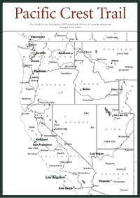
[Fig. 60] The 2,650-mile Pacific Crest Trail covers more ground than any other route on the West Coast. The Pacific Crest stretches over 24 national forests and 33 wildernesses from the Canadian border to the Mexican border. In California alone, the trail is 1,723 miles long. It covers more than 500 miles in the Sierra Nevada.
There are people who walk for four to six months and complete an end-to-end trip. Richard Watson is reportedly the first person ever to hike the whole trail. He did it in 1972. But many folks hike the Pacific Crest in segments. In fact, some people hike segments of the segments because even smaller chunks of the Pacific Crest can be pretty long.
The longest Pacific Crest stretch in California is 177 miles of high-elevation trail that coincides with a large part of the John Muir Trail from the Southern Sierra to Yosemite National Park. That stretch takes most experienced and fit hikers three weeks to a month.
There are many strategies for walking the Pacific Crest Trail, but the common thread among them is packing and traveling light. Two decades ago, people commonly carried a 50-, 60-, or even 70-pound pack. Now, with ultralight backpacking techniques, people carry 20- to 25-pound packs and travel much farther in a single day. Other people use llamas to pack their provisions. Llamas, which are native to high-elevation areas, adapt well to carrying loads in the high Sierra.
The history of the Pacific Crest Trail can be traced to the 1920s when the first serious discussions about it began. The trail was the product of many minds. Clinton C. Clarke, a Southern California resident and chairman of the Mountain League of Los Angeles, organized the Pacific Crest Trail System Conference in 1932. But the idea had been considered since the mid-1920s among several groups on the West Coast.
It took several decades of exploration, trail work, and lobbying before the federal government included the Pacific Crest in a 1968 law called the National Trails System Act. The act established the existing Appalachian Trail and the Pacific Crest as the first two National Scenic Trails. A general trail route was federally approved for the Pacific Crest in the early 1970s.
The Pacific Crest National Scenic Trail Advisory Council was named to develop the detailed route and management plan for the trail. The council held its first meeting in 1970. There were representatives of all three states involved—Washington, Oregon, and California—as well as cattle ranchers, timber and mineral interests, youth organizations, and Native Americans.
 In
1977, the Pacific Crest Trail Association was incorporated as construction
of the trail progressed. The association acted as an advocacy group for
the trail and assisted the government with volunteer work crews to maintain
and protect the trail. Today the group continues its advocacy and trail
work and provides information on everything from trail ethics to food supply
points along the route.
In
1977, the Pacific Crest Trail Association was incorporated as construction
of the trail progressed. The association acted as an advocacy group for
the trail and assisted the government with volunteer work crews to maintain
and protect the trail. Today the group continues its advocacy and trail
work and provides information on everything from trail ethics to food supply
points along the route.
The association worked with the U.S. Forest Service, the National Park Service, the Bureau of Land Management, and a dizzying array of local governments and private landowners to establish and maintain the trail. In 1993, after years of land acquisition, trail cutting, and work on mapping, the trail was officially dedicated as a National Scenic Trail, a quarter of a century after it had been established as a National Scenic Trail.
The Pacific Crest has five sections, each several hundred miles long. The Southern California section is 648 miles; Central California is 505 miles; Northern California is 567 miles; Oregon is 430 miles; and Washington is 500 miles. Much of the trail is under snow throughout the winter, especially in the Sierra Nevada. The optimum travel months in the Sierra are July, August, and September.
The trail is marked with signs, not blazes. Even so, do not attempt any lengthy section of the Pacific Crest without a good topographic map, compass, and path-finding skills. Plan the trip many months in advance to make sure you get the proper permits, which can be obtained from U.S. Forest Service in each of the forests through which the trail passes. In many parts of the Sierra, exit routes may mean a halfday or more of hiking. The Pacific Crest has a remarkable amount of foot traffic, so you probably will not be alone. But be prepared to handle problems on your own.
For more information: Pacific Crest Trail Association, 5325 Elkhorn Boulevard, Suite 256, Sacramento, CA 95842-2526. Phone (916) 349-2109.
Read and add comments about this page